| | Thumbnail | | Creator | Date | Title / Author / Date / Location | Price | | | Description |
| 1001 | 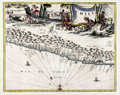 | Details | Montanus, Arnoldus | 1671 |
| Chile (Chile) South America |
|
Montanus, Arnoldus |
|
| 1671 |
| LOC:0 |
| $0.00 | Montanus--Arnoldus | Chile-(Chile)-South-America | SOLD<br></br>
Attractive map of coastal Chile ("Chili") in South America by Arnoldus Montanus, after Ogilby. From Montanus' "De Nieuwe en Onbekende Weereld: of Beschryving van America." Shows the major portion of Chile between 25 and 45 degrees south latitude. The Andes ("Sierra nevado de los Andes") are shown in profile, and most of the major bays and islands are identified by name. Key features include Arauco, Concepcion, la Mocha island, Santiago (St. Jago de la Nueva Estres madura), Rio Mapocho, la Serena, and Rio Copiapo.
<br></br>
Very decorative map with a large scene of industrious natives and cherubs. The ocean is filled with two Spanish galleons and a compass rose. |
| 1091 | 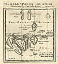 | Details | Moll, Herman | 1699 |
| First printed map to focus on the Galapagos Islands |
|
Moll, Herman |
|
| 1699 |
| LOC:0 |
| $0.00 | Moll--Herman | First-printed-map-to-focus-on-the-Galapagos-Islands | SOLD<br></br>
Very scarce map of the Galapagos Islands and the earliest printed map of the Galapagos. |
| 442 |  | Details | Duché de Vancy, Gaspard | 1797 |
| Insulaires et monumens de l'lle de Paque |
|
Duché de Vancy, Gaspard |
|
| 1797 |
| LOC:0 |
| $0.00 | Duché-de-Vancy--Gaspard | Insulaires-et-monumens-de-l-lle-de-Paque | SOLD<BR> </BR>
View of inhabitants and monuments on Easter Island, in the Pacific Ocean, now a possession of Chile. Two of the famous stone heads are shown along with crew members and islanders.<BR> </BR>
Drawn by Gaspard Duchè de Vancy, a French artist of the 18th century. From the "Atlas du Voyage de La Perouse" published by Jean-Francois La Perouse. La Perouse led a scientific exploration to the Pacific from 1785, accompanied by Duchè de Vancy, and sent the drawing on which this engraving is based to France in 1788 with the intention of returning home by 1789. Departing Botany Bay, Australia in March, 1788 neither La Perouse, his ships the Boussole or Astrolabe, nor his men were ever seen again. Number 11.<BR> </BR>
Believe the engraving is an early 20th century re-strike from the original copper plate produced by the French Chalcographie du Louvre. La Chalcographie du Louvre is a repository of more that 13,000 original plates from the Louvre's archives, housed upstairs above the Louvre's Paris galleries . Upon request visitors can have a engraving produced on museum-quality paper from the original plate by a master printer. V.15 <BR> </BR> |
| 5480 | 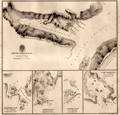 | Details | King, Peter Parker | 1840 |
| Rare charts of Smyth and Fury Harbor Magellan Strait Chile |
|
King, Peter Parker |
|
| 1840 |
| LOC:89 |
| $0.00 | King--Peter-Parker | Rare-charts-of-Smyth-and-Fury-Harbor-Magellan-Strait-Chile | SOLD<br><br>Very rare engraved chart of Smyth Harbor, Fury Harbor and three other harbors of refuge, all along the Barbara Channel, one of three channels that connects the <strong>Strait of Magellan</strong> to the Pacific Ocean [1]. By Captain Phillip Parker King R.N. and printed just ten years after King surveyed the area aboard the Adventure, a stout ship of 330 tons.
Chart # 1306. London. 1840.
<br></br>
King named Smyth Harbor after Captain (later Admiral) William Henry Smyth who had commanded the Adventure before King and who was an early member of a number of learned societies, well known for his hydrographic charts, for his astronomical work, and for a wide range of publications in varied fields.
<div class="indenttextblocksingle">
"On the south side of Mount Maxwell is Smyth Inlet, which contains anchorage on the north shore, particularly one in Earle Cove; but in the centre the water is deep, and on that account, it is not an inviting place for a ship. [2]"</div>
<br>
Scale below graduated in "Nautic Miles". Rhumb lines subtly visible only near margins. Admiralty, December 24, 1840. R.B. Bate Agent for Admiralty Charts 21 Poultry.
<br></br>
[1] The other two channels connecting Magellan Strait to the Pacific are Abra Channel and Magdalena Channel. </br>
[2] King, P. P. Narrative of the surveying voyages of His Majesty's Ships Adventure and Beagle between the years 1826 and 1836, describing their examination of the southern shores of South America, and the Beagle's circumnavigation of the globe. Proceedings of the first expedition, 1826-30, under the command of Captain P. Parker King, R.N., F.R.S. London: Henry Colburn. 1839. [Online]. |
| 982 |  | Details | Depot de la Marine | 1867 |
| Plan of the Entrance to Valdivia Bay |
|
Depot de la Marine |
|
| 1867 |
| LOC:51 |
| $550.00 | Depot-de-la-Marine | Plan-of-the-Entrance-to-Valdivia-Bay | Antique French sea chart of the entrance to <b>Corral Bay</b> and the Valdivia estuary, situated to the southwest of the city of <b>Valdivia, Chile</b>. Clearly shows Mancera Island ("Ile Mansera") , Fort Niebla, Fort St. Carlos, Fort d"Amargos, and St Jean Bay. Two attractive elevation views of the coastline at the entrance to Valdivia River.
<br></br>
This edition of the old nautical chart was published in 1867 and contains changes made by French Naval officers Lartigue and Flury to an earlier survey by Ange René Armand, Baron de Mackau, Captain of the French 58-gun Frigate, the Clorinde (1822). The <b>Baron de Mackau</b> had been given command of the Clorinde which he sailed to the Pacific in order to conduct negotiations with the nascent states of Chile and Peru, in South America.
<br></br>
Inset plan of Corral Bay at bottom right: "Plan Particulier de l'Anse du Corral" with a small walled encampment, the "Chateau du Corral".
<br></br>
With an oval-shaped black ink overstamp from the seller in Harve, France. |
| 345 |  | Details | Depot de la Marine | 1872 |
| Carte Particuliere de la Cote Sud-Ouest d'Amerique |
|
Depot de la Marine |
|
| 1872 |
| LOC:67 |
| $355.00 | Depot-de-la-Marine | Carte-Particuliere-de-la-Cote-Sud-Ouest-d-Amerique | Large mid-nineteenth century antique nautical chart from the French Depot de la Marine. This antique chart is made more interesting by the display of extensive topographical relief details of the coastal margins. Detailed coverage of the Southwest coast of Patagonia (Chile) from the Western approach to the Strait of Magellan (near the Evangelistas group of islands) north to the Gulf of Penas. An inside route is shown that would have permitted 19th century navigators to bypass at least some of the lower Pacific. Features include Mont Burney, insets of Hevre de l"isle and Anse Colombine; numerous islands, archipelagos, and straits. <BR> </BR>
Corrected version from 1872 of a chart first published in 1851. No. 1307. With circular stamp of Depot General de la Marine. |
| 647 | 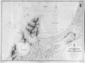 | Details | British Admiralty Hydrographical Office | 1879 |
| Coquimbo Bay and Port Herradura, Chile |
|
British Admiralty Hydrographical Office |
|
| 1879 |
| LOC:67 |
| $175.00 | British-Admiralty-Hydrographical-Office | Coquimbo-Bay-and-Port-Herradura--Chile | British Admiralty chart of the Coquimbo Peninsula in north-central Chile, just south of the tourist destination of La Serena. Detailed topography and hydrography with numerous soundings about the town and bay of Coquimbo, Chile and the adjacent Port Herradura. Based on the survey by Captain Richard C. Mayne, R.N. and the officers of H.M.S. Nassau, 1868.
<br></br>
Features include Whale Rock, the town of Herradura (in ruins), Cuyacan, the English cemetery, a Chilean cemetery, Signal Hill, Tortuga Point with lighthouse, and four smelting works. Railroad lines are located both to Serena and to Panucillo.
<br></br>
Originally published at the Admiralty, London on May 1, 1869 and corrected in August 1873. Sold by J.D. Potter. 31 Poultry and 11 King Street, Tower Hill. |
| 5090 | 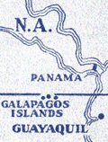 | Details | Diamond Match Company | 1942 |
| Galapagos Islands survey by U.S.S. Bowditch match book cover |
|
Diamond Match Company |
|
| 1942 |
| LOC:13 |
| $40.00 | Diamond-Match-Company | Galapagos-Islands-survey-by-U-S-S--Bowditch-match-book-cover | Scarce matchbook cover for the 386-foot U.S. Navy survey vessel U.S.S. Bowditch with an index map for their cruises of 1942-1943 to the Galapagos Islands, a part of Chile. Manufactured by the Diamond Match Company N.Y.C.
<br></br>
The USS Bowditch (AG 30) was first launched in 1929 at Copenhagen, Denmark, as the passenger ship Santa Inez. The Bowditch was outfitted as a surveying vessel and commissioned on 1 July 1940, with Commander E. E. Duval in command.
<br></br>
Departing Norfolk on 9 January 1942, the U.S.S. Bowditch steamed south to conduct surveys of the waters between Panama and Colombia, off the Galápagos Islands, and off the Cocos Islands in Costa Rica.
<br></br>
The following U.S. Navy charts were based on surveys conducted by the U.S.S. Bowditch in 1942 and 1943:
<div class="indenttextblocksingle">
<ul style="list-style-type: circle;">
<li># 5936 Approaches to Bahia Bartago, Archipielago de Colon (Galapagos Islands). 1942.</li>
<li># 5921 Eastern Approaches to Canal de San Salvador, Archipielago Colon (Galapagos Islands). 1943.</li>
<li># 5931 Western approaches to Canal Bolivar, Archipielago de Colon (Galapagos Island). 1942.</li>
<li># 5920 Isle Baltra, Archipielago de Colon (Galapagos Islands). 1942.</li>
<li># 5959: Golfo de Guyaquil. 1943.</li>
</ul>
</div>
The USS Bowditch was decommissioned in January, 1947 |