| | Thumbnail | | Creator | Date | Title / Author / Date / Location | Price | | | Description |
| 978 | 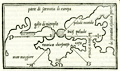 | Details | Bordone, Benedetto | 1534 |
| 16th century wood-cut map of Crimea and the Sea of Azov |
|
Bordone, Benedetto |
|
| 1534 |
| LOC:7 |
| $750.00 | Bordone--Benedetto | 16th-century-wood-cut-map-of-Crimea-and-the-Sea-of-Azov | Very scarce antique map of the <b>Crimean Peninsula</b> by Paduan cartographer Benedetto Bordone in 1534. Includes southern Ukraine labeled "parte di sarmatia di europa". With the Sea of Azov as "palude meotide" (<b>the Maeotis Swamp</b>) or "bicis palude". These names were applied in antiquity dating to Greek and Roman times.
<br></br>
The Strait of Kerch is labeled "bosphoro crinerico" and on the west side of Crimea "golfo di nigropila" is applied to Karkinitski or Karkinitsky Bay. An unnamed city is shown in the location held today by <b>Yalta</b>. The body of water we today call the Black Sea is labeled "mar maggiore" by Bordone.
<br></br>
This scarce antique map was published from Venice in 1534, just 42 years after Christopher Columbus first landed in the New World. From the second edition of Benedetto di Bordone's "Isolario" which provided nautical-chart inspired maps of islands alongside information for travellers on their culture, myths, climate, and history.
<br></br>
Bordone (1460-1531) was an illustrator of manuscripts, best known for his 'Isolario' or book of islands. Bordone's work was only the second isolario ever printed, the first being that of Bartolommeo Dalli Sonneti published in 1485. Text on verso in Italian. |
| 4832 | 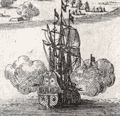 | Details | Limiers, Henri Philipp de | 1721 |
| Fine etched view of Kronstadt and St. Petersburg, Russia |
|
Limiers, Henri Philipp de |
|
| 1721 |
| LOC:13 |
| $265.00 | Limiers--Henri-Philipp-de | Fine-etched-view-of-Kronstadt-and-St--Petersburg--Russia | Early original engraved view of fortifications of Kronstadt (Cronstadt), Russia which Peter the Great founded on Kotlin (Retusari) Island in winter 1704 during the Great Northern War. Kotlin Island separates Neva Bay from the rest of the Gulf of Finland.
<br></br>
Despite the frigid conditions Imperial Russian forces quickly erected fortifications on the island:
<div class="indenttextblocksingle">
Under the command of Governor-general … Menshikov, workers used thousands of frames made of oak logs filled with stones which were carried by horses across the frozen sea, and placed in cuttings made in the ice. Thus, several new small islands were created, and forts were erected on them, virtually closing access to Saint-Petersburg by sea. Only two narrow navigable channels remained, with forts guarding them. (Online: https://en.wikipedia.org/wiki/Kronstadt).
</div>
<br/>
A few of the major features on this antique view of St. Petersburg may be identified by letter:
<div class="indenttextblocksingle">
<ul style="list-style-type: circle;">
<li>A- St. Petersburg, Russia</li>
<li>C - Kotlin Island (Retusari)</li>
<li>D- Kronstadt Fortifications</li>
</ul>
</div>
From "Histoire de Suede sous le Regne de Charles XII" by Limiers. Published from Amsterdam by Jansons & Waesberge. Tome 4. Page 188.
<br></br>
This view predates Bodenher's later, derivative print "Prospect von S. Petersgurg und der Insul Retusari" by 14 years. |
| 2498 |  | Details | Olearius, Adam | 1727 |
| Map and elevation view of Arkhangelsk, Russia |
|
Olearius, Adam |
|
| 1727 |
| LOC:7 |
| $120.00 | Olearius--Adam | Map-and-elevation-view-of-Arkhangelsk--Russia | Antique map and view of Arkhangelsk, Russia (Archangel; Archangelsk), the administrative center of Arkhangelsk Oblast, in the north of European Russia. Arkhangelsk is today situated on both banks of the northern Dvina River near its exit into the White Sea.
<br></br>
From "Voyages très-curieux & très renommez faits en Moscovie, Tartarie, et Perse...." by Adam Olearius (1603-1671). |
| 4839 |  | Details | Tardieu, Pierre Antoine | 1783 |
| Antique Chart of the Sea of Azov Azof and Crimean Peninsula |
|
Tardieu, Pierre Antoine |
|
| 1783 |
| LOC:88 |
| $675.00 | Tardieu--Pierre-Antoine | Antique-Chart-of-the-Sea-of-Azov-Azof-and-Crimean-Peninsula | Fine original antique map of the Sea of Azov ( Azof ) and environs, based on Jan-Hendrik Van Kinsbergen's 1774 manuscript map of Crimea (formerly Ukraine; annexed by Russia in March 2014.) Detailed inset chart of the Kerch Strait (Detroit de Zabache) linking the Sea of Azov to the Black Sea. |
| 4794 | 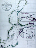 | Details | Faden, William | 1803 |
| Antique Chart of the Baltic Sea, Gulf of Bothnia and Gulf of Finland |
|
Faden, William |
|
| 1803 |
| LOC:57 |
| $350.00 | Faden--William | Antique-Chart-of-the-Baltic-Sea--Gulf-of-Bothnia-and-Gulf-of-Finland | Fine antique British nautical chart of the Baltic Sea by William Faden. Inset port and harbor chart of Cronstadt (Kronstadt) on Kotlin Island and Saint Petersburg, Russia. Separate inset harbor chart for Revel (Tallinn, Estonia) on the shore of the Gulf of Finland. Coverage on the chart extends from Copenhagen at bottom right, to Stockholm and far into the Gulf of Bothnia.
<br></br>
Published by W. Faden, Geographer to the King, and to H.R.H. the Prince of Wales, Charing Cross, June 4, 1803. Engraved by S.I. Neele, Strand. |
| 4949 | 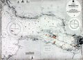 | Details | British Admiralty Hydrographical Office | 1919 |
| St. Petersburg Russia Petrograd Bay (Neva Bay) |
|
British Admiralty Hydrographical Office |
|
| 1919 |
| LOC:62 |
| $675.00 | British-Admiralty-Hydrographical-Office | St--Petersburg-Russia-Petrograd-Bay-(Neva-Bay) | Antique nautical chart of PETROGRAD BAY (Neva Bay) and St. Petersburg, Russia copied from Russian Surveys made between 1831-1894. Manuscript corrections in red ink dated to 1919. Lighthouses and other navigational aids are marked in orange.
<br></br>
First published at the Admiralty March 19, 1855 under the superintendence of Captain Washington. Sold by J.D. Potter. This issue with final minor corrections up to 1919. Chart number 2279.
<br></br>
Four inset sketches of important local aids to navigation including:
<br></br>
<div class="indenttextblocksingle">
<ul style="list-style-type: circle;">
<li>Krasnaya Gorka Signal Station</li>
<li>Pitka Point Tower</li>
<li>Stirs Point Lighthouse</li>
<li>Tolbenkin Lighthouse</li>
</ul>
</div> |
| 5393 | 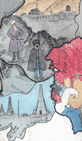 | Details | Anonymous | 1930 |
| Fragments of a manuscript illustrated map of the Caucasus early oil industry |
|
Anonymous |
|
| 1930 |
| LOC:2 |
| $190.00 | Anonymous | Fragments-of-a-manuscript-illustrated-map-of-the-Caucasus-early-oil-industry | Fragments of a larger manuscript pictorial map ca. 1930 of the Soviet Caucasus with early oil industry views. The fragments feature inhabitants of the republics in traditional outfits, some views of the oil derricks and traditional "bazaar" (marketplaces). Illustration of oil derricks show them enclosed in a fabric-covered frame to protect the drilling equipment against the very harsh cold.
<br></br>
The first fragment features Tajik, Turkmen & Uzbek ASSR. The second fragment features Dagestan ASSR, Kabardino-Balkar ASSR, Transcaucasian SFSR and other autonomous republics.
<br></br>
Attributed to a GIZ / IZOGIZ State design bureau worker. Izogiz was the fine arts section of Ogiz publishing. Ink, pencil, gouache on paper. |