| | Thumbnail | | Creator | Date | Title / Author / Date / Location | Price | | | Description |
| 361 | 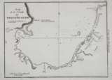 | Details | Direccion Hidrografia | 1809 |
| Plano de la Bahia del Pequeno Guave |
|
Direccion Hidrografia |
|
| 1809 |
| LOC:5 |
| $500.00 | Direccion-Hidrografia | Plano-de-la-Bahia-del-Pequeno-Guave | Rare antique nautical / harbor chart of Pequeno Guave (Petit-Goâve) Haiti, one of the oldest cities in the country. Coverage includes from punta Agujereada to punta de Piedras.<BR> </BR>
Published in 1809, this large-scale port/harbor chart is one of 22 charts (on 16 plates) of ports in Haiti, Dominican Republic and Jamaica published by the Spanish Admiralty, the Direccion Hidrografia, in Part IV of the atlas "Portolano de la America Setentrional Construido en la Direccion Detrabajos Hidrograficos". Because of Spain's secrecy about its New World territories these charts represent some of the earliest detailed charts of these areas. These antique charts do not often appear on the market. Plate Number 11. Scale in cables.<BR> </BR>
Reference: Materiales para una Cartografia Mexicana. Manuel Orozco y Berra. 1871. p. 216. |
| 364 | 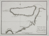 | Details | Direccion Hidrografia | 1809 |
| Puerto del Mole de San Nicolas |
|
Direccion Hidrografia |
|
| 1809 |
| LOC:5 |
| $400.00 | Direccion-Hidrografia | Puerto-del-Mole-de-San-Nicolas | On the northwest section of Haiti, Mole San Nicolas is located just 50 miles from Baracoa, Cuba. This rare chart of the bay and harbor chart of Mole San Nicolas shows the city firmly established at the time of the survey with these features: Almacen de Polvora (gunpowder magazine), quarteles, and la Ciudad protected by a defensive wall.<BR> </BR>
Published in 1809, this large-scale port/harbor chart is one of 22 charts (on 16 plates) of ports in Haiti, Dominican Republic and Jamaica published by the Spanish Admiralty, the Direccion Hidrografia, in Part IV of the atlas "Portolano de la America Setentrional Construido en la Direccion Detrabajos Hidrograficos". Because of Spain's secrecy about its New World territories these charts represent some of the earliest detailed charts of these areas. These small charts do not often appear on the market. Plate Number 9. Scale in cables.<BR> </BR>
Reference: Materiales para una Cartografia Mexicana. Manuel Orozco y Berra. 1871. p. 216. |
| 374 | 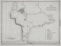 | Details | Direccion Hidrografia | 1809 |
| Plano de Puerto de Delfin (Santo Domingo) |
|
Direccion Hidrografia |
|
| 1809 |
| LOC:5 |
| $500.00 | Direccion-Hidrografia | Plano-de-Puerto-de-Delfin-(Santo-Domingo) | Interesting chart of what is today the Bay of Fort Liberte, Haiti. The city of Fort Liberte has changed hands several times and with each occupation the French, Spanish, and British renamed the city: from Bayaha, to Fort-Dauphin (Delfin in Spanish for dolphin), to Fort St. Joseph and finally in 1820 to Fort Liberte. The chart shows a sizeable settlement and a legend to the right explains several of the key features including two cannon batteries and four forts: Fuerte Ardubin, Fuerte Federico, Fuerte de la Boca, and Fuerte Delfin. Plate Number 3. Scale in cables.<BR> </BR>
Published in 1809, this large-scale port/harbor chart is one of 22 charts of ports in Haiti, Dominican Republic and Jamaica (on 16 plates) published by the Spanish Admiralty, the Direccion Hidrografia, in Part IV of the atlas "Portolano de la America Septentrional Construido en la Direccion Detrabajos Hidrograficos". Because of Spain's secrecy about its New World territories these charts represent some of the earliest detailed charts of these areas. <BR> </BR> |
| 24 | 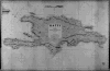 | Details | James Imray and Son | 1885 |
| Haiti (Blueback) |
|
James Imray and Son |
|
| 1885 |
| LOC:0 |
| $0.00 | James-Imray-and-Son | Haiti-(Blueback) | NOT AVAILABLE
<BR> </BR>
Large, handsome, original blueback nautical chart of Haiti / San Domingo (now the Dominican Republic) from James Imray and Son with the eastern-most tip of Cuba visible. Strong graphic composition. Profile view at top of "Port Paix or Valpariso, distant 3 miles". <BR> </BR>
The original, antique nautical chart is surrounded with six compass roses and is marked with the Imray globe / laurel wreath emblem . Four lighthouses are highlighted in yellow, while the title cartouche inset contains the following warning: "The lights are of inferior brilliancy and badly attended: some of them may not be shown." <br/><br/>
Verso contains complete yellow Imray publishers label: "Chart No. 119 Haiti or San Domingo".
<BR> </BR>
For more information on the evolution of blueback charts we recommend this book by Susanna Fisher:
<a target="_blank" href="http://www.regattapress.com/The_Makers_of_the_Blueback_Chart.html">The Makers of Blueback Charts.</a> |