| | Thumbnail | | Creator | Date | Title / Author / Date / Location | Price | | | Description |
| 688 | 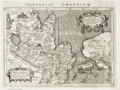 | Details | Magini, Giovanni Antonio | 1598 |
| Asia and U.S. West Coast- Tartariae Imperium |
|
Magini, Giovanni Antonio |
|
| 1598 |
| LOC:6 |
| $450.00 | Magini--Giovanni-Antonio | Asia-and-U-S--West-Coast--Tartariae-Imperium | Very old antique map of China, Japan, Russia, and the West Coast of the United States : "Americae vel Novi Orbis Pars" by G.A. Magini ca. 1598. California is identified by name and is shown attached to the continent. Alaska and Canada are truncated with the coast of North America shown trending to the North rather than to the West. Above North America the Scythian Ocean "Oceanus Scythicus" extends to the Arctic Circle. There is a hint of the Mississippi River drainage but it is greatly misplaced to the West and empties into the "Mar Vermeio" or Vermillion Sea. Also mis-identified is the "Stretto di Anian", part of the much sought after but elusive Northwest Passage. North of Japan, in the vicinity of the Bering Sea, not discovered at that time, the author identifies "Mare Cin".
<br></br>
This old map of Asia is characterized by careful, neat engraving and lettering with the continents set apart from the sea by a finely stippled background.
<br></br>
Coverage includes Cazones, Y. de Cedri (Cedros Island) off the coast of Baja California, "Y delle Perle" or Pearl Islands off the coast of Panama. Cartouches contain Latin inscriptions while the surrounding text is in Italian. After an earlier map by Abraham Ortelius ca. 1570. Page 167. Plate XXVIII (28). |
| 5237 | 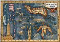 | Details | Bertius, Petrus | 1609 |
| Antique map of the East Indies or Moluccas |
|
Bertius, Petrus |
|
| 1609 |
| LOC:6 |
| $190.00 | Bertius--Petrus | Antique-map-of-the-East-Indies-or-Moluccas | Interesting original miniature antique map of the Maluku Archipelago or Moluccas near the Banda Sea ca. 1609 by Petrus Bertius. Includes Sulawesi, Timor, Seram and numerous other islands in the Malaku province of Indonesia. |
| 1381 | 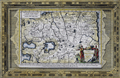 | Details | Aa, Pieter van der | 1713 |
| Fine antique framed map of Tartary or north central Asia |
|
Aa, Pieter van der |
|
| 1713 |
| LOC:0 |
| $240.00 | Aa--Pieter-van-der | Fine-antique-framed-map-of-Tartary-or-north-central-Asia | Matted and framed…
<br></br>
Attractive, framed copper-engraved antique map of Tartary by Pieter van der Aa. The name "Tartary" was used until the twentieth century to designate the great tract of northern and central Asia stretching from the Caspian Sea and the Ural Mountains to the Pacific Ocean. Tartary consisted of the high plateau of central Asia and its north-western slopes, which formed part of the Tartar empire in the Middle Ages.
<br></br>
Includes the Black Sea ("Pontus Euxinus"), Caspian Sea ("Mare Caspium") and western Mediterranean Sea ("Mare Mediterraneum"). Covers parts or all of modern-day Turkey, Iran, Georgia, Azerbaijan, Syria, Iraq, China, Nepal, and Afghanistan.
<br></br>
Matted and framed measures 17" x 13". Map itself, ca. 1713 within an elaborate and decorative printed border.
<br></br>
Pieter van der Aa (1659 - 1733) was a Dutch publisher working in Leiden during the early eighteenth century. He is best known for publishing maps and atlases, though he also printed pirated editions of foreign bestsellers and illustrated volumes. Van de AA's use of stock mock-frame borders is a characteristic for which he is well known. The map shows evidence of two plate marks, one for the mock-frame and the second interior platemark for the smaller map which was printed inside the mock-frame. From "Le nouveau theatre du monde. ou La geographie royale, composée de nouvelles cartes tres-exactes", published from Leiden in 1713. |
| 1357 | 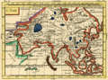 | Details | Duchesne, J.B.P. | 1729 |
| Fine antique hand colored map of Asia |
|
Duchesne, J.B.P. |
|
| 1729 |
| LOC:41 |
| $99.00 | Duchesne--J-B-P- | Fine-antique-hand-colored-map-of-Asia | Interesting small antique map of Asia by the Jesuit J.B.P. Duchesne published in "La Science de La Jeune Noblesse", a two volume manual written by Duchesne and published in Paris in 1729 with a set of world maps. The maps in that volume were part of a manual intended for young noblemen which also included heraldry and genealogical tables. |
| 685 | 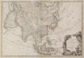 | Details | Janvier, Robert (Jean) | 1762 |
| l'Asie Divisee en Ses Principaux Etats |
|
Janvier, Robert (Jean) |
|
| 1762 |
| LOC:9 |
| $350.00 | Janvier--Robert-(Jean) | l-Asie-Divisee-en-Ses-Principaux-Etats | An attractive, hand-colored antique map depicting the Asian continent from the Red Sea in the West to Java and the Moluccas in the South as far East as the Bering Strait. This old map covers Saudi Arabia, India, Iraq, Iran, the Caspian Sea, Black Sea, Japan, Sumatra, Borneo, Java, Malaku Islands ( Isles Moluques ), Phillipine Islands, Korea ( Coree ), Japan and Kamchatka. In South East Asia, New Guinea ( Nouvelle Guinee ) is elongated with an indistinct outline of its coasts stretching off the map, hinting at a connection with Australia.
<br></br>
Janvier further identifies the mythical 'Detroit du Nord ou d'Anian' off the easternmost point of the Asian Continent. Anian is generally considered to be an undiscovered land or strait in the extreme northwestern part of America. The earliest known reference to Anian is in the narratives of Marco Polo, who describes it as 'East of India'. In many early maps Anian appears as an imaginary proto-Bering Strait, the Strait of Anian, separating Asia from America as part of the Northwest Passage, which was hoped would shorten the passage to the riches of the orient. The concept of the Strait of Anian lingered on maps after the Bering Strait was explored by Vitus Bering in 1728, until the northwest coast of North America had been well mapped.
<br></br>
Title cartouche at right suggests the rich and exotic destinations on the map through a depiction of rugs and other riches along with incense burning in a large censer topped with a crescent signifying Islamic origin.
<br></br>
Published by Lattre as plate 24 in "Atlas moderne ou collection de cartes sur toutes les parties du globe terrestre ar plusieurs auteurs." Paris, 1762 with Royal Privilege. |
| 1406 | 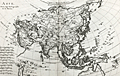 | Details | Bonne, Rigobert | 1780 |
| Nice antique map of Asia with Australia |
|
Bonne, Rigobert |
|
| 1780 |
| LOC:9 |
| $160.00 | Bonne--Rigobert | Nice-antique-map-of-Asia-with-Australia | Antique map of Asia by French hydrographer Rigobert Bonne. Coverage on this copper-plate engraved map includes Saudi Arabia, India, China, New Guinea, northern Australia ("Nouvelle Hollande"), New Zealand., Japan, Korea, and much more. Coverage extends far to the east to include Alaska with the Bering Strait and the Alaska Peninsula. No. 28.
<br></br>
Rigobert Bonne (1727-1794) was the successor to Jacques Nicolas Bellin as Royal Cartographer to France in the office of the Hydrographer at the Depôt de la Marine. Bonne first came to prominence when he published a number of charts in the Atlas Maritime in 1762. He is better known for later publications, including the Atlas Encyclopedique, which he collaborated on with Nicholas Desmarest, as well as the maps he produced for Raynal's Atlas de Toutes Les Parties Connues du Globe Terrestre, which was published in 1780. This map is from Raynal's atlas. |
| 3632 | 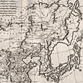 | Details | Bonne, Rigobert | 1787 |
| Fine antique map of China, Korea and Japan |
|
Bonne, Rigobert |
|
| 1787 |
| LOC:9 |
| $265.00 | Bonne--Rigobert | Fine-antique-map-of-China--Korea-and-Japan | Map of China, Korea and Japan includes only northern China, extending south as far as Nanjing. Numerous cities are shown spread throughout China, however fewer are shown in Korea and Japan reflecting the lack of knowledge of these regions in the late 18th century. The Great Wall of China is also depicted.
<br></br>
Rigobert Bonne (1727-1794) was the successor to Jacques Nicolas Bellin as Royal Cartographer to France in the office of the Hydrographer at the Depôt de la Marine. Bonne first came to prominence when he published a number of charts in the Atlas Maritime in 1762. He is better known for later publications, including the Atlas Encyclopedique, which he collaborated on with Nicholas Desmarest, as well as the maps he produced for Raynal's Atlas de Toutes Les Parties Connues du Globe Terrestre, which was published in 1780. |
| 1382 |  | Details | Mentelle and Chanlaire | 1798 |
| Fine antique 18th-century map with Europe and Asia |
|
Mentelle and Chanlaire |
|
| 1798 |
| LOC:9 |
| $220.00 | Mentelle-and-Chanlaire | Fine-antique-18th-century-map-with-Europe-and-Asia | Beautifully engraved and hand-colored map centered on the Arabian Peninsula with much of that area designated "Arabia Deserta". Includes Scandinavia, north Africa, India, China, Sri Lanka ("Taprobana"), and much more. The title indicates that the coverage includes those portions of the world's surface that were known to exist in antiquity. Engraved by Tardieu.
<br></br>
The curved map projection and the fine coloring work act synergistically to emphasize the curvature of the earth's surface.
<br></br>
Published from Paris by French cartographers E. Mentelle and Pierre-Giles Chanlaire. Edme Mentelle (1730 - 1816) was a French geographer and historian in Paris who studied under the historian Jean-Baptiste Louis Crevier at the College of Beauvais. After accepting a position as professor of Geology and History at the Ecole Militaire he tutored students including the young Napoleon Bonaparte. Mentelle published a number of important geographical works including the 1778 Geographie Comparee, the 1779 Atlas Universel, and the 1801 Cours Complet de Cosmographie, de Chronologie, de Geographie et d'Histoire. Plate 3. |
| 6771 |  | Details | Touanne, Edmund Bigot de la | 1837 |
| Bougainville elevation views Port Jackson Rio de Janiero Da Nang Hainan Macao |
|
Touanne, Edmund Bigot de la |
|
| 1837 |
| LOC:130 |
| $800.00 | Touanne--Edmund-Bigot-de-la | Bougainville-elevation-views-Port-Jackson-Rio-de-Janiero-Da-Nang-Hainan-Macao | Sheet of coastal elevation views after drawings by Edmund Bigot de la Touanne (1796-1863) and engraved by Ambroise Tardieu (1) for "Journal de la navigation autour du globe de la Fregate la Thetis et de la corvette l 'Esperance." That journal documents the circumnavigation of Bougainville (2) during 1824 through 1826 aboard the Thetis and Esperance.
<br><br>
Plate 54. 1837.
<br><br>
The coasts depicted include the Philippine Island of Luzon; Guangzhou (Canton) China; Macao, China; Hainan, China; Da Nang, Vietnam; Lombok, Indonesia; Surabaya, Indonesia; Sydney, Australia; and Rio de Janeiro, Brazil. Descriptions of the views are translated here from the original text in French:
<div class="indenttextblocksingle">
<ul style="list-style-type: decimal;">
<li>Vue d'une partie de la cote Nord-Ouest de I'lle Lucon (Philippines) prise le 20 Decembre 1824</li>
<li>Vues de Piedra Branca a l'atterage du Golfe de Canton (Chine) prises le 24 December 1824</li>
<li>Vue du passage de Lantao a l'entree du Golfe de Canton (Chine) prises le 24 December 1824</li>
<li>Vue de la Ville de Macao (Chine) prises en Janvier 1825</li>
<li>Vue d'une partie de la cote est de I'lle d'Hainan (Chine) prises le 10 Janvier 1825</li>
<li>Vue de l'Entree de la Baie de Tourane (Cochinchine) prise le a Janvier 1825</li>
<li>Vue du Mouillage de Tourane (Cochinchine) prise en Fevrier 1825</li>
<li>Vue de I'lle Lombock (Archipel de al Sonde) prise le 10 Mai 1825</li>
<li>Vue de la Rade de Sourabaya a l'est de Java (Archipel de la Sonde) prise en Avril 1825</li>
<li>Vu de la Ville de Sidney au Port Jackson (Nouvelle Galles Meridionale) prise en Aout 1825</li>
<li>Vue de l'Entrée de la Baie de Rio Janeiro(Bresil) prise le Avril 1828.</li>
</ul>
</div> |
| 4957 | 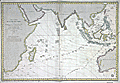 | Details | Depot de la Marine | 1862 |
| Fine French chart of the East Indies |
|
Depot de la Marine |
|
| 1862 |
| LOC:59 |
| $1,075.00 | Depot-de-la-Marine | Fine-French-chart-of-the-East-Indies | 1862 edition of a French nautical chart of the Indian Ocean and East Indies first published by the French Depot General de la Marine in 1837. French nautical charts of the Indian Ocean are scarce. No record of a sale of this chart is found in the AMPR.
<br></br>
This chart of the Indian Ocean to western Australia is based on exploration led by Daussy (Chief Hydrographer) and Wissocq. Engraved by Chassant. With contemporary manuscript ink annotations of a ship's daily course plotted east bound past the Cape of Good Hope and again west bound on the home trip. The positions extend far to the east, past the Philippine islands, another 4 days cruise past the neatline, and terminate at "Pelew" or the island of Palau.
<br></br>
Coverage includes a wide swath of ocean extending from Africa and Madagascar to Australia, Borneo, and Eastern China.
<br></br>
Published by order of the King. Seller's paste-on label at bottom right: "SAUVAT Libraire Rue Saint-Remy 3, a Bordeaux." |
| 5378 | 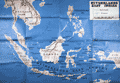 | Details | Army Orientation Branch | 1943 |
| WWII Training Map of Southeast Asia |
|
Army Orientation Branch |
|
| 1943 |
| LOC:300 |
| $0.00 | Army-Orientation-Branch | WWII-Training-Map-of-Southeast-Asia | SOLD
<br></br>
Large original WWII era U.S. Army orientation training map of east Asia (East Indies) ca. 1943.
<br></br>
Includes Vietnam ("French Indo-China"), Thailand, Myanmar ("Burma"), Philippine Islands, Singapore, New Guinea, Sumatra, and Australia. Major cities include Saigon, Bangkok, Batavia, Manila, and Darwin. |