| | Thumbnail | | Creator | Date | Title / Author / Date / Location | Price | | | Description |
| 2507 | 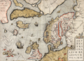 | Details | Ortelius, Abraham | 1570 |
| Scarce map of the Arctic and Scandinavia |
|
Ortelius, Abraham |
|
| 1570 |
| LOC:10 |
| $2,200.00 | Ortelius--Abraham | Scarce-map-of-the-Arctic-and-Scandinavia | Ortelius' map of the Arctic, including Scandinavia, Iceland, Greenland and part of the North American continent, includes the legendary islands of Drogeo, Frisland and Icaria. This fine map, with original color, is adorned with a variety of very inventive creatures including a half-man, half-sea creature with bird feet playing a lute. Second state with a triangular dot added at the end of the title. |
| 439 |  | Details | Anonymous | 1744 |
| A Whale Female and the Windlass |
|
Anonymous |
|
| 1744 |
| LOC:0 |
| $0.00 | Anonymous | A-Whale-Female-and-the-Windlass | SOLD<br></br>
Copper-plate engraving of a dead whale lying on the Greenland shore prior to butchering. A worker has marked a grid on the whale and is about to begin work removing the blubber with a large flensing tool. Shows windlasses and a sled used to haul the carcass ashore. Originally published in 1619, this state is from Churchill's Collection of Voyages & Travel (1744) vol. I. Page 444. |
| 1156 | 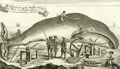 | Details | Anonymous | 1744 |
| A Whale Female and the Windlass whereby the Whales are brought on shore |
|
Anonymous |
|
| 1744 |
| LOC:1 |
| $275.00 | Anonymous | A-Whale-Female-and-the-Windlass-whereby-the-Whales-are-brought-on-shore | Fine antique copper-plate engraving of a dead whale lying on the Greenland shore prior to flensing. A worker has marked a grid on the whale and is about to begin work removing the blubber with a large flensing tool. Shore-based flensing or cutting of the whales flesh was the method used by Nantucketer's during their early shore fishery . As the fishery moved offshore flensing was conducted by bringing the whale alongside the whaling ship. Illustrates Monck's "Account of a Most Dangerous Voyage to Greenland".
<br></br>
Shows windlasses, a sled, anchor, and flensing tools used to haul the carcass ashore and remove the whale's blubber.
<br></br>
Originally published in 1619, this state is from Churchill's Collection of Voyages & Travel (1744) vol. I. Page 444. |
| 1157 | 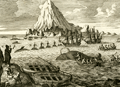 | Details | Anonymous | 1744 |
| Antique Greenland offshore whaling engraving |
|
Anonymous |
|
| 1744 |
| LOC:0 |
| $0.00 | Anonymous | Antique-Greenland-offshore-whaling-engraving | SOLD
<br></br>
Fine antique copper-plate engraving of the ships and boats engaged in the whaling process ca 1620. Illustrates John Monck's "Account of a Most Dangerous Voyage to Greenland" based on his voyage in 1619 and 1620.
<br></br>
Monck described the scene:
<div class="indenttextblock">
"The manner of catching and killing of the whales is performed thus: As soon as they spy a whale either from the shore or ship they put out three chalops manned with six men each, among whom is one being called the Harpuner, is the person who is first to wound the whale with his harpun." [Note: A chalop or shallop is a light sailing boat mainly used as a fishing tender].
</div>
</br>
Originally published in 1619, this state is from Churchill's Collection of Voyages & Travel (1744) vol. I. Page 442. |
| 1192 | 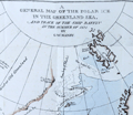 | Details | Manby, George William | 1823 |
| Journal of a Voyage to Greenland, in the year 1821 |
|
Manby, George William |
|
| 1823 |
| LOC:0 |
| $1,800.00 | Manby--George-William | Journal-of-a-Voyage-to-Greenland--in-the-year-1821 | An arctic whaling classic. Scarce second edition (1823) of this illustrated account of the whaling ship Baffin’s voyage with Captain Scoresby. The main purpose of the voyage was to test a new harpoon design by Scoresby. The voyage took them first to Spitzbergen, along the coast of Greenland, to Iceland and then home.
<br></br>
George Manby accompanied Captain Scoresby on the voyage into the northern Greenland Sea aboard the whaling ship Baffin. Manby creates a vivid picture of Arctic whaling as it was practiced during the early part of the 19th Century. Scoresby invented a harpoon gun and is also remembered for his life-saving apparatus. Numerous woodcuts in the text of whales, narwhal, and other arctic creatures.
<br></br>
With a fine hand-colored folding map "A General Map of the Polar Ice in the Greenland Sea and Track of the Ship Baffin in the Summer of 1821 by G.W. Manby (14" x 10"). Contains 20 uncolored lithographic plates illustrating the voyage. Five plates "Drawn on stone by J.D. Harding" are larger and folded:
<div class="indenttextblock">
<ul style="list-style-type: circle;">
<li>Striking a Whale with Third Harpoon</li>
<li>A Whale Upsetting a Boat</li>
<li>Lancing a Whale</li>
<li>A Bear Attacking A Boat</li>
<li>A Boat Going on the Tail of a Fish</li>
</ul>
</div>
In 1819 William Scoresby moved to Liverpool from Whitby where he built (1820) and commanded the whaling ship "Baffin". In 1822 Scoresby mapped the East coast of Greenland. The "Baffin" finally sank in 1830 when 19 out of 90 ships in the whaling fleet were lost in bad weather in the Davis Strait. Scoresby's plans, together with this scale model of his ship are in the Whitby Museum, Yorkshire, England.<a href="http://www.whitbymuseum.org.uk/hpmimages/index1.htm " target="_blank"> (Internet. 2016.)</a>
<br></br>
Printed for G. and W.B. Whittaker, Ave Maria Lane, London. 225 pages including an appendix illustrated with woodcuts of harpoons and lance heads. |