| | Thumbnail | | Creator | Date | Title / Author / Date / Location | Price | | | Description |
| 963 | 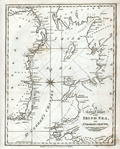 | Details | Malham, John | 1797 |
| A Correct Chart of the Coasts of the Irish Sea and St. Georges Channel |
|
Malham, John |
|
| 1797 |
| LOC:0 |
| $0.00 | Malham--John | A-Correct-Chart-of-the-Coasts-of-the-Irish-Sea-and-St--Georges-Channel | SOLD
<br><br/>
Antique engraved nautical chart of the Irish Sea with the coasts of Scotland, Wales, and Ireland. From the rare first American edition of <b>Malham's Naval Gazetteer</b>, published by Spotswood and Nancrede in Boston in 1797. Probably the earliest small-scale map of the coasts along the Irish Sea to be printed in the United States (1797). Chart coverage extends from Rathlin Island in the North, with the Isle of Man and Angelsey, Solway Firth, Cardigan Bay, and St. Georges Channel terminating past Milford Haven. Key cities include Belfast and Dublin, Ireland; Liverpool, Lancaster; and Carmarthen, Wales.
<BR> </BR>
Adorned with decorative compass rose and three sets of rhumb lines. Unlike several other charts in Malham's volume this example contains no depth soundings or descriptions of the sea-floor composition.
<BR> </BR>
This chart comes from an early nautical gazetteer or geographical dictionary produced first in England and after 1796 in the United States by John Malham. Rev. John Malham was a prolific Yorkshire-born author who produced other diverse works that include "Navigation Made Easy and Familiar", "Twenty-Two Sermons on Doctrinal and Practical Subjects" and "The Scarcity of Wheat considered". Malham died near London in 1807. (Gentleman's Magazine, Vol 102, 1807, p. 568).
<BR> </BR>
Colophon at end of Volume 1 states that the work is "From the prefs of Samuel Etheridge, No. 9 Newbury Street, Boston, 1797"). |