| | Thumbnail | | Creator | Date | Title / Author / Date / Location | Price | | | Description |
| 925 | 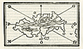 | Details | Bordone, Benedetto | 1534 |
| First printed map of the Caribbean island of Hispaniola |
|
Bordone, Benedetto |
|
| 1534 |
| LOC:5 |
| $900.00 | Bordone--Benedetto | First-printed-map-of-the-Caribbean-island-of-Hispaniola | The first printed large-scale map of the Caribbean island of <b>Hispaniola</b> which is shared by two nations: the Dominican Republic and Haiti. Also the first printed map to show the earliest settlement in the New World (other than a Viking settlement)- <b>La Isabela</b> ("Isabella"). During his second voyage in 1493 Christopher Columbus founded La Isabela on the central north coast of Hispaniola, in what is today the Dominican Republic. Map is inset onto a full page of Italian text.
<br></br>
This scarce antique map was published from Venice in 1534, just 42 years after Christopher Columbus first landed in the New World. From the second edition of Benedetto di Bordone's "Isolario di Benedetto Bordone Nel qual si ragiona di tutte l'Isole del mondo, con li lor nomi antichi & moderni, historie, favole, & modi del loro vivere, & in qual parte del mare stanno, & in qual parallelo & clima giaciono. Con la gionta del Monte del Oro novamente ritrovato". The Isolario provided nautical-chart inspired maps of islands alongside information for travellers on their culture, myths, climate, and history. Bordonne depicts the interior of the island as mountainous with numerous rivers flowing to the sea.
<br></br>
Bordone (1460-1531) was a Paduan cartographer, and an illustrator of manuscripts, best known for his 'Isolario' or book of islands. Bordone's work was only the second isolario ever printed, the first being that of Bartolommeo Dalli Sonneti published in 1485. Text on verso in Italian. |
| 809 | 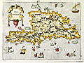 | Details | Porcacchi, Tomasso | 1686 |
| Antique map of Spagnola, or Hispaniola |
|
Porcacchi, Tomasso |
|
| 1686 |
| LOC:0 |
| | Porcacchi--Tomasso | Antique-map-of-Spagnola--or-Hispaniola | SOLD<br></br>
17th century, antique copperplate-engraved map of the Caribbean island of Hispaniola, shared by the nations of Haiti and nearby Dominican Republic. In this decorative map numerous mythical sea serpents, and sailing vessels fill empty space in the Caribbean Sea.
</br></br>
Noted points of interest include numerous capes and headlands: Cabo de los Lobos; Cabo de San Rafael; Cabo Arecifes; and the intriguing Punta del Plata e dell Argento. The village of S. Domingo is shown but no habitation is noted in the area of Port Au Prince, Haiti.
<br></br>
This small, colorful map was printed in 1686 in one of the last editions of Tomasso Porcacchi's "Isolario" or island book " L'Isol Piu Famose Del Mondo" which was first published in Venice ca. 1572. This 1686 edition is differentiated from earlier versions of Porcacchi's atlas in that 1) it is the only edition where the maps are not set within printed text, and 2) the chart was re-engraved for this edition and the compass rose is less elaborate.
<br></br>
On the compass rose Porcacchi identifies eight points that correspond to the classical eight-point naming convention for Mediterranean winds that dates back at least 2000 years. Porcacchi's compass rose symbols "T", "G", "+" , "S", "O", "L", "P", "M", correspond to the Italian names for the principal Mediterranean winds: Tramontana ( North ), Greco, Levante ( with a cross denoting East ), Sirocco, Ostro ( South ), Libeccio. Ponente ( West ), and Maestro. ( Taylor, E.G.R., "The Haven Finding Art: A History of Navigation from Odysseus to Captain Cook". New York. 1957 (pp. 6-8)
<br></br>
Ample margins and attractive hand-coloring make this antique map of Hispaniola a fine candidate for framing. |
| 3674 |  | Details | Price, Charles | 1743 |
| Chart of the Island of Hispaniola and Windward Passage |
|
Price, Charles |
|
| 1743 |
| LOC:0 |
| $0.00 | Price--Charles | Chart-of-the-Island-of-Hispaniola-and-Windward-Passage | SOLD <br></br>
Fine British chart of Hispaniola (Haiti/Dominican Republic) with eastern Cuba and the southern Bahamas. Contains two compass half roses. By Charles Price, a publisher, globe and instrument maker, and engraver.
<br></br>
Although printed in 1743, the chart has cartographic inspiration back to "Chart if the Iland of Hispaniola with the Windward Passage from Jamaica…" by William Fisher (1689), John Thornton (1698), several Mounts and Pages."
<br></br>
Charles Price apprenticed to John Seller and he planned to published a maritime atlas covering the whole world, but the venture was not a success and was never completed. Price was a debtor in Fleet Street Prison at the end of 1731. After Price's death (ca. 1733) his plates passed to Mount & Page, who added their names lower left. Sold by William Mount and Thomas Page, Tower Hill, London.
<br></br>
This map is from the English Pilot. The Fourth Book "Describing the West-India Navigation, from Hudson’s Bay to the River Amazones. Particularly Delineating The Coasts, Capes, Headlands, Rivers, Bays, Roads, Havens, Harbours, Streights, Rocks, Sands, Shoals, Banks, Depths of Water, and Anchorage, with all the Islands therein; as Jamaica, Cuba, Hispaniola, Barbadoes, Antigua, Bermudas, Porto Rico, and the Rest of the Caribee and Bahama Islands." The first edition of the English Pilot in 1689 was the first English atlas up to that time to include charts solely of American waters. |
| 175 |  | Details | Chedel | 1754 |
| Ville de St. Domingo |
|
Chedel |
|
| 1754 |
| LOC:0 |
| $0.00 | Chedel | Ville-de-St--Domingo | SOLD
<br></br>
Colorful antique engraving shows a birds-eye view of the Port of Santo Domingo with a small fort off to the right guarding the entrance channel. |
| 1396 | 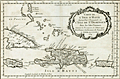 | Details | Bellin, Jacques Nicolas | 1754 |
| Caribbean Antique Map with Hispaniola (Hayti), Porto Rico, Jamaica |
|
Bellin, Jacques Nicolas |
|
| 1754 |
| LOC:0 |
| $285.00 | Bellin--Jacques-Nicolas | Caribbean-Antique-Map-with-Hispaniola-(Hayti)--Porto-Rico--Jamaica | Matted and framed.
<br></br>
Original mid 18th-century French map of Caribbean islands centered on the island of Hispaniola with Haiti and Santo Domingo by Nicolas Bellin. The island of Hayti ( Haiti ) is shown divided into the five pre-Columbian cacicazgos, or Taino kingdoms. Puerto Rico is named I. Boriquen or S. Jean Baptiste. Nearly all of Jamaica is shown, as well as the eastern half of Cuba, the Turks and Caicos islands, and the Bahamas as far north as Cat Island.
<br></br>
Size with frame 18" x 15".
<br></br>
Published in a French edition of L'Abbe Prevost's "Histoire Générale des Voyages". Tome 12, No. 1. |
| 1084 | 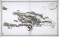 | Details | Depot de la Marine | 1803 |
| Antique French Chart of the Dominican Republic and Haiti |
|
Depot de la Marine |
|
| 1803 |
| LOC:51 |
| $750.00 | Depot-de-la-Marine | Antique-French-Chart-of-the-Dominican-Republic-and-Haiti | Old French map of Saint Dominque- the island of Hispaniola not yet divided into political entities of Haiti and the Dominican Republic. Topography is shown in relief with extensive shading and hachuring. There is extensive depiction of the roads, rivers, and towns that populate the interior of the island. While the map does provide the user with visual geographic details, the is no information either of elevation of the terrain, nor are there any depth soundings.
<br</br>
The map was published by the Depot de la Marine in "An XI" - the 11th year after the French Revolution of 1803. Two changes on the map from an earlier edition of the same map published before the revolution are that the Depot de la Marine logo incorporates the letters "R.F." (Republique francaise) and the town previously denoted as "Port au Prince" is called "Port Republicain" in the post-revolutionary edition. |
| 359 | 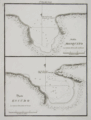 | Details | Direccion Hidrografia | 1809 |
| Bahia Mosquito, Puerto Escudo |
|
Direccion Hidrografia |
|
| 1809 |
| LOC:5 |
| $400.00 | Direccion-Hidrografia | Bahia-Mosquito--Puerto-Escudo | Rare nautical / harbor charts of Bahia Mosquito and Puerto Escudo, Santo Domingo (Dominican Republic).
<BR> </BR>
Published in 1809, these antique large-scale port/harbor charts are two of 22 charts of ports in Haiti, Dominican Republic and Jamaica (on 16 plates) published by the Spanish Admiralty, the Direccion Hidrografia, in Part IV of the atlas "Portolano de la America Setentrional Construido en la Direccion Detrabajos Hidrograficos". Because of Spain's secrecy about its New World territories these charts represent some of the earliest detailed charts of these areas. These antique nautical charts do not often appear on the market. Plate Number 7. Scale in cables.<BR> </BR>
Reference: Materiales para una Cartografia Mexicana. Manuel Orozco y Berra. 1871. p. 216. |
| 360 | 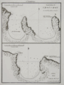 | Details | Direccion Hidrografia | 1809 |
| Fondeadero de Chouchou, Bahia de la Granja |
|
Direccion Hidrografia |
|
| 1809 |
| LOC:5 |
| $400.00 | Direccion-Hidrografia | Fondeadero-de-Chouchou--Bahia-de-la-Granja | Antique nautical / harbor charts of Fondeadero de Chouchou (N. coast of Haiti) and Bahia de la Granja, Haiti.<BR> </BR>
Published in 1809, these two large-scale port/harbor charts are two of 22 charts (on 16 plates) of ports in Haiti, Dominican Republic and Jamaica published by the Spanish Admiralty, the Direccion Hidrografia, in Part IV of the atlas "Portolano de la America Setentrional Construido en la Direccion Detrabajos Hidrograficos". Because of Spain's secrecy about its New World territories these antique harbor charts represent some of the earliest detailed charts of these areas. These small charts do not often appear on the market. Plate Number 5. Scale in cables.<BR> </BR>
Reference: Materiales para una Cartografia Mexicana. Manuel Orozco y Berra. 1871. p. 216. |
| 362 | 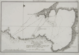 | Details | Direccion Hidrografia | 1809 |
| Plano de la Bahia de S. Lorenzo |
|
Direccion Hidrografia |
|
| 1809 |
| LOC:5 |
| $400.00 | Direccion-Hidrografia | Plano-de-la-Bahia-de-S--Lorenzo | l scarce harbor chart of San Lorenzo Bay, near Sabana de La Mar, in Hato Mayor, Santo Domingo (now the Dominican Republic). Coverage includes several sandbanks and Rio San Lorenzo.<BR> </BR>
Published in 1809, this large-scale antique port/harbor chart is one of 22 charts (on 16 plates) of ports in Haiti, Dominican Republic and Jamaica published by the Spanish Admiralty, the Direccion Hidrografia, in Part IV of the atlas "Portolano de la America Setentrional Construido en la Direccion Detrabajos Hidrograficos". Because of Spain's secrecy about its New World territories these charts represent some of the earliest detailed charts of these areas. These antique nautical charts do not often appear on the market. Plate Number 16. Scale in nautical miles ("milla maritima").<BR> </BR>
Reference: Materiales para una Cartografia Mexicana. Manuel Orozco y Berra. 1871. p. 216. |
| 363 | 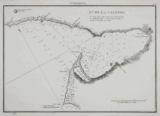 | Details | Direccion Hidrografia | 1809 |
| Punta de la Caldera |
|
Direccion Hidrografia |
|
| 1809 |
| LOC:5 |
| $400.00 | Direccion-Hidrografia | Punta-de-la-Caldera | Scare antique nautical harbor chart of Punta de la Caldera (Calderas), Santo Domingo (now the Dominican Republic), on the south coast of that island. Coverage includes from punta de Burros to punta de Salinas. At the location where the Base Naval de las Calderas is now located there is depicted a single small shack. Other features include: punta Intermedia, Punta de Mata-Sola, Caleton, punta Morrillos, casimba de agua dulce (Translated: 'bucket of sweet water'), punta de las Garzas, and punta Rancheros. Numerous soundings, anchorages, and rocks are noted.<BR> </BR>
Published in 1809, this large-scale port/harbor chart is one of 22 charts (on 16 plates) of ports in Haiti, Dominican Republic and Jamaica published by the Spanish Admiralty, the Direccion Hidrografia, in Part IV of the atlas "Portolano de la America Setentrional Construido en la Direccion Detrabajos Hidrograficos". Because of Spain's secrecy about its New World territories these charts represent some of the earliest detailed charts of these areas. These small antique charts do not often appear on the market. Plate Number 13. Scale in cables.<BR> </BR>
Reference: Materiales para una Cartografia Mexicana. Manuel Orozco y Berra. 1871. p. 216. |
| 375 | 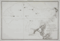 | Details | Direccion Hidrografia | 1809 |
| Plano de las Ensenadas de Monte-Cristi y Manzanillo |
|
Direccion Hidrografia |
|
| 1809 |
| LOC:200 |
| $450.00 | Direccion-Hidrografia | Plano-de-las-Ensenadas-de-Monte-Cristi-y-Manzanillo | Early chart by the Direccion Hidrografia of the northwest coast of the Dominican Republic including the Bay of Montecristi and the Bay of Manzanillo and the town of Montecristi. Much of this area now comprises the Parque Nacional Montecristi. The chart's coverage includes the offshore islands in that area, doubtless the source of the name "los siete hermanos" (the seven brothers) including Cayo de Arenas, Cayo Rataas, Cayo Tercero, Cayo de Muertos, and Cayo Totoru . Somewhat larger that the other charts from the Portolano. Plate Number 2. Scale in cables.<BR> </BR>
Published in 1809, this large-scale port/harbor chart is one of 22 charts of ports in Haiti, Dominican Republic and Jamaica (on 16 plates) published by the Spanish Admiralty, the Direccion Hidrografia, in Part IV of the atlas "Portolano de la America Septentrional Construido en la Direccion Detrabajos Hidrograficos". Because of Spain's secrecy about its New World territories these charts represent some of the earliest detailed charts of these areas. <BR> </BR> |