| | Thumbnail | | Creator | Date | Title / Author / Date / Location | Price | | | Description |
| 5162 | 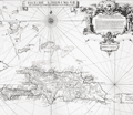 | Details | Frezier, Amedee | 1725 |
| Isle de S. Domingue |
|
Frezier, Amedee |
|
| 1725 |
| LOC:51 |
| $300.00 | Frezier--Amedee | Isle-de-S--Domingue | Map of the island of Hispaniola by Amedee Francois Frezier (1682-1773). Includes portions of the Bahamas, Cuba, Jamaica, and Puerto Rico. Decorative dedicatory cartouche.
<br><?br>
Includes an inset plan "Plan de la Ville Espagnole de S. Domingue". Condition issues at right margin but should mat and frame nicely. |
| 3657 | 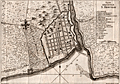 | Details | Masi, Tommaso Gio. | 1763 |
| Plan of the walled city of Santo Domingo. |
|
Masi, Tommaso Gio. |
|
| 1763 |
| LOC:77 |
| $350.00 | Masi--Tommaso-Gio- | Plan-of-the-walled-city-of-Santo-Domingo- | Scarce engraved antique nautical plan (after Thomas Jefferys) of the walled town of Santo Domingo on the island of Hispaniola. With a legend explaining numerous important locations on the plan including Fort San Girolamo, the Cathedral, and the Palace of Christopher Columbus (Cristoforo Colombo). Includes the bar across the entrance to the Ozama River as well as suggested anchorages within the river. Details on roads surpasses what is typical for nautical plans of this era. Italian text.
<br></br>
Originally published in the Gazzetiere Americano, from Livorno, Italy. Contains a few depth soundings and notations of the composition of the sea bottom, important to navigators who had to rely heavily on lead-line measurements for safe passage. Engraved by Giuseppe Pazzi and drawn by Viol. Vanni. |