| | Thumbnail | | Creator | Date | Title / Author / Date / Location | Price | | | Description |
| 7887 | 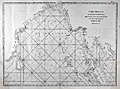 | Details | Mannevillette, d'Apres | 1775 |
| Malacca Strait Bay of Bengal, from the Isle of Ceylon Gulf of Siam |
|
Mannevillette, d'Apres |
|
| 1775 |
| LOC:141 |
| $495.00 | Mannevillette--d-Apres | Malacca-Strait-Bay-of-Bengal--from-the-Isle-of-Ceylon-Gulf-of-Siam | A fine 18th-century nautical chart of the Bay of Bengal ."Carte Reduite du Golfe de Bengale, depuis L'Isle De Ceylan jusqu'au Golfe De Siam, avec la partie Septentrionale du Detroit De Malac". Produced by Jean-Baptiste Nicolas Denis d'Après de Mannevillette (1707-1780).
<br><br>
It depicts the Bay of Bengal region, extending from Ceylon (present-day Sri Lanka) to the Gulf of Siam (now known as the Gulf of Thailand), and include the northern part of the Strait of Malacca.
<br><br>
<div style="text-align: center;font-size:105%;">
<i>Professional hand coloring for this chart is available at a very modest fee.</i>
</div> |
| 5135 | 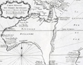 | Details | Prevost, Antoine-Francois | 1753 |
| Histoire générale des voyages tome onzième v 11 |
|
Prevost, Antoine-Francois |
|
| 1753 |
| LOC:2001 |
| $1,750.00 | Prevost--Antoine-Francois | Histoire-générale-des-voyages-tome-onzième-v-11 | Volume 11 of Prevost's history of voyages to the south sea. Contains accounts of the explorations of Narborough, Wood, Anson, Dampier, Carieri and others. Plates of unusual animals and six plates of botannicals with copper-engraved maps as below. <b>Includes two very desirable, foundational maps of Australia</b> with the continent shown attached to Tasmania:
<div class="indenttextblocksingle">
<ul style="list-style-type: circle;">
<li>"Carte reduite des Terres Australes pour servir …" by Nicolas Bellin. 1753. (11" x 8"). Very good.</li>
<li>"Carte reduite de la Mer du Sud pour servir ..." by Nicolas Bellin. 1753. (14" x 8"). Good. </li>
</ul>
</div>
French text. Volume 11- tome onzième. Second Partie. "Histoire Generale des voyages, ou nouvelle collection de toutes les relations de voyages par mer et par Terre, qui ont ete publiees jusqu'a present dans les differentes langues de toutes les nations connue …". Published by Didot from Paris in 1753.
<br></br>
Contents include but are not limited to these plates:
<div class="indenttextblocksingle">
<ul style="list-style-type: circle;">
<li>Carte reduite de la partie la plus meridionale de l'Amerique No. 1</li>
<li>Carte reduite du Detroit de Magellan No. 2</li>
<li>Carte de l'Isle de Caienne No. 3</li>
<li>La Ville de Cayenne No. 4</li>
<li>Carte du Detroit de le Maire No. 5</li>
<li>Carte particuliere de l'Isle de Juan Fernandez No. 6</li>
<li>Coste du Nord Est de l'Isle de Juan Fernandez No. 7</li>
<li><b>Carte reduite des Terres Australes No. 8</b></li>
<li><b>Carte reduite de la Mer du Sud No. 9</b></li>
<li><b>Representation du cours ordinaires des vents … Mer du Sud</b> No. 10</li>
<li>Vue de la Place de Juan Fernandez No. 13</li>
<li>Batiment leger des Isles de Larrons No. 14</li>
</ul>
</div> |
| 5094 |  | Details | U.S. Congress | 1891 |
| Map supplement showing boundaries of congressional districts in 1891 |
|
U.S. Congress |
|
| 1891 |
| LOC:2001 |
| $300.00 | U-S--Congress | Map-supplement-showing-boundaries-of-congressional-districts-in-1891 | Scarce volume of maps and population statistics for 1880 and 1890 published as a supplement to the congressional directory. Maps show counties/parishes and boundaries of congressional districts.
<br></br>
With exceptions noted below, 43 maps show all the states admitted to the Union as of 1890. The following states are not mapped as they had not been admitted to the Union: Arizona, New Mexico, Utah, Oklahoma, District of Columbia, Alaska, Hawaii.
<br></br>
By W.H. Michael, Clerk of Printing Records. Washington. Government Printing Office. 1891. 123 pages. |
| 5088 | 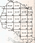 | Details | Rockford Map Publishers | 1975 |
| Atlas and Plat Book Suwannee County Florida 1975 |
|
Rockford Map Publishers |
|
| 1975 |
| LOC:2001 |
| $200.00 | Rockford-Map-Publishers | Atlas-and-Plat-Book-Suwannee-County-Florida-1975 | Atlas and Plat Book Suwannee County Florida 1975, published by Rockford Map Publishers, Inc. Rockford, Illinois. Sponsored by Daniel Crapps, Realtor, Live Oak, Florida.
<br></br>
Contents contain an index map for Suwannee County; an alphabetized business directory; important facts about land descriptions; detailed maps for each of 23 townships in the index map; a map of the capital city of Suwannee County- Live Oak; a map of the city of Branford; and a reduced general highway map of Suwannee County, Florida. |
| 1387 |  | Details | Michel fils | 1834 |
| Atlas Universal a small French pocket Atlas. |
|
Michel fils |
|
| 1834 |
| LOC:0 |
| $250.00 | Michel-fils | Atlas-Universal-a-small-French-pocket-Atlas- | Atlas Universel with 30 small steel-engraved maps. Followed by a 24-page section of definitions and explanations of geographic locations in French. With original paper covers.
<br></br>
Published by Michel fils aine [the elder brothers] , Paris, Rue de la Hachette, No. 24 |
| 1007 |  | Details | U.S. Coast and Geodetic Survey | 1851 |
| Coast Survey Atlas (Sketches for the 1851 Annual Report) |
|
U.S. Coast and Geodetic Survey |
|
| 1851 |
| LOC:0 |
| $400.00 | U-S--Coast-and-Geodetic-Survey | Coast-Survey-Atlas-(Sketches-for-the-1851-Annual-Report) | About 57 nautical charts (many folded) in a single volume showing the hydrographic sketches and preliminary surveys of the U.S. East and West Coast. Bookplate: "With the compliments of A.D. Bache", Alexander Dallas Bache (1806-1867), then the superintendent of the United States Coast Survey.
<br></br>
Inserted, loose list of "Coast Survey Charts Published" dated within at March 15, 1853. Lists charts, sketches and preliminary charts, free sketches, and the names and residences for agents selling Coast Survey charts. Size: 9" x 22". On better paper. |
| 262 | 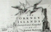 | Details | Mackenzie, Murdoch (Senior) | 1750 |
| Survey of the Orkney and Lewis Islands. (Atlas of 8 folio plates) |
|
Mackenzie, Murdoch (Senior) |
|
| 1750 |
| LOC:0 |
| $5,655.00 | Mackenzie--Murdoch-(Senior) | Survey-of-the-Orkney-and-Lewis-Islands--(Atlas-of-8-folio-plates) | This important, intact, and scarce folio-sized antique atlas of 8 plates is a landmark in cartography by Orkney native Murdoch Mackenzie Senior (1712 - 1797). This antique nautical atlas of the Orkney Islands, published in 1750 is Mackenzie's first published work and is considered to be the most accurate survey in Britain up to the mid 18th century. </br> </br>
<strong><a style="color:#9BAFCB" href= "/MackenzieAtlasViewer.aspx">[ Browse the entire atlas ]</a></strong> </br> </br>
In 1962 A.G.W. Robinson wrote about the unique characteristics of Mackenzie's first charts: "Some of the conventions he adopted, for example showing bottom deposits by a letter under the relevant sounding, are still in use on present day charts."
<br></br>
Contents include Title Page, Subscriber list, A 14 page History of the Orkneys, 8 charts of the Orkneys, Pomona, and the Lewis.
<br></br>
Reference: Robinson, A.H.W. 'Marine Cartography in Britain'. Leicester University Press. 1962. pp. 60-70. |
| 230 |  | Details | Michelot and Bremond | 1730 |
| Recueil de plusieurs plans des ports et rades de la mer mediterranee. (Atlas of 37 plates) |
|
Michelot and Bremond |
|
| 1730 |
| LOC:0 |
| $6,500.00 | Michelot-and-Bremond | Recueil-de-plusieurs-plans-des-ports-et-rades-de-la-mer-mediterranee---(Atlas-of-37-plates) | Scarce and complete atlas of 37 large-scale 10" x 7" antique engraved Mediterranean port and harbor plans by French hydrographers and galley (galère, Fr.) pilot Henry Michelot and Laurens Bremond. </br> </br>
<strong><a href= "/MBPlansViewer.aspx">[ Browse all 37 charts here ]</a></strong>
</br></br> This 12" x 8" atlas, published ca. 1730 was the culmination of Henry Michelot's career; the result of at least 40 years experience as pilot of the Reale, premier vessel in the galley service of Louis XIV and XV. These charts are influenced by and bear similarities to a set of manuscript charts published by Michelot from Marseille around 1689 but are updated to reflect his cumulative experience over the intervening 40 years. With an elaborately engraved title page. Some charts engraved by Peter Starck-man. <BR> </BR>
This 290-year old sea atlas contains port plans from France, Italy, and Spain including Barcelona, Antibe, Mayorca, Bay of Naples, Bay of Gibraltar, and Cadiz. Several of these charts (e.g. Cadiz, Gibraltar) were considered to be the most authoritative works of that era and were copied by others including Thomas Kitchin well into the mid 18th century.<BR> </BR>
For more information on the life and works of Henry Michelot and his business partner Bremond see our <a rel="nofollow" href= "/MichelotBremondBackground.aspx">brief illustrated biography.</a> |