| | Thumbnail | | Creator | Date | Title / Author / Date / Location | Price | | | Description |
| 719 | 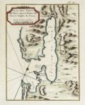 | Details | Bellin, Jacques Nicolas | 1771 |
| Plan of Buccari ( Bakar ) and Porto-Re ( Kraljevica), Croatia |
|
Bellin, Jacques Nicolas |
|
| 1771 |
| LOC:7 |
| $200.00 | Bellin--Jacques-Nicolas | Plan-of-Buccari-(-Bakar-)-and-Porto-Re-(-Kraljevica)--Croatia | Beautifully colored 18th century French antique map / plan of the Bay of Bakar including Buccari, Croatia with Buccariza and Porto-Re, now Kraljevica. A few soundings and anchorages noted and two chateau, but much emphasis on the fortifications and batteries, containing in total 41 cannon. By J.N. Bellin, cartographer for the French Depot de la Marine.
<br></br>Published in Paris (1771) by Didot in "Description géographique du Golfe de Venise et de la Morée : avec des remarques pour la navigation et des cartes et plans des côtes, villes, ports et mouillages". Plate 14. |
| 1438 | 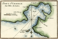 | Details | Roux, Joseph | 1780 |
| Roux antique plan of Vis (Lucca) harbor in Croatia |
|
Roux, Joseph |
|
| 1780 |
| LOC:2 |
| $125.00 | Roux--Joseph | Roux-antique-plan-of-Vis-(Lucca)-harbor-in-Croatia | Attractive, antique nautical chart / port plan of the town and harbor on the island of Vis, Croatia, ("Lissa") off the Dalmatian Coast, in the Adriatic Sea. Vis is furthest island in the Adriatic from the Croatian coast and lies southwest of the islands of Hvar, Brac and Solta.
<BR> </BR>
The port of Vis is identified by Roux as "Lucca". Other key features on this port plan include "Cut", "St. Spilice", "Calle St. George", "Calle Stance", and "Pointe Argentine". On the small and high offshore island of Otočić Host, Roux notes a "Reconnaissance pour le Mouillage" or a place to view the anchorage at Vis.
<BR> </BR>
For many years Vis was the military and naval headquarters of Tito’s partisan army and was closed to the public until 1989. This meant that it largely escaped commercial development and has been able to retain its natural beauty. Plate 85.
<BR> </BR>
Joseph Roux Sr. (1725-1793) was a French cartographer and hydrographer who lived in Marseille. The Roux family, with Roux's son Jospeh Jr. and grandson Antoine Roux, was involved in marine cartography and marine painting from Marseille into the mid-19th century. |