| | Thumbnail | | Creator | Date | Title / Author / Date / Location | Price | | | Description |
| 6705 | 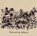 | Details | John Player and Sons | 1938 |
| Unrecorded thematic pictorial tobacco advertising map |
|
John Player and Sons |
|
| 1938 |
| LOC:40 |
| $1,000.00 | John-Player-and-Sons | Unrecorded-thematic-pictorial-tobacco-advertising-map | Fine unrecorded advertising world map "Tobacco" published by John Player and Sons (1) circa 1938 (2). The map shows graphically the sources where tobacco was grown as well as shipping routes for tobacco cargos to England. Inset tables for: the four methods of curing tobacco; and the United Kingdom's principal sources of supply of different types of tobacco. Sketches at top and bottom of the map show the various steps in the growth, shipment, and preparation of Player's various tobacco products including cigarettes.
<br><br>
Not found in WorldCat. No example or record of a sale of the Tobacco map is found online.
<br><br> |
| 6602 | 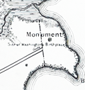 | Details | Lindenkohl, A. | 1897 |
| Map of Washington's Birthplace by Coast and Geodetic Survey |
|
Lindenkohl, A. |
|
| 1897 |
| LOC:1404 |
| $300.00 | Lindenkohl--A- | Map-of-Washington-s-Birthplace-by-Coast-and-Geodetic-Survey | Fine map of Washington's birthplace published by the U.S. Coast and Geodetic Survey based on a survey by Adolph Lindenkohl in 1879, but 1897. Photo-lithograph by Andrew B. Graham. Scarce, <b>only one copy of the survey map was located in WorldCat and no copies in the AMPR.</b>
<br><br>
George Washington was born in 1732 on Pope's Creek Plantation in Westmoreland County, Virginia.
<br><br>
Price when issued was 20 cents (upper left) but that price is crossed out and replaced in manuscript with "30". Note at bottom right: "Location of Monument and other data added in 1897."
<br><br>
Map # 3081. Scale 1/10,000 |
| 5339 | 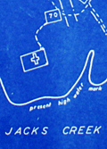 | Details | Somberg, Seymour I. | 1950 |
| Blueprint plat map of Cedar Grove Plantation St. Paul South Carolina |
|
Somberg, Seymour I. |
|
| 1950 |
| LOC:1401 |
| $900.00 | Somberg--Seymour-I- | Blueprint-plat-map-of-Cedar-Grove-Plantation-St--Paul-South-Carolina | Unrecorded blueprint or cyanotype plat map of <b>Cedar Grove Plantation</b> or Smythe Plantation, <b>St. Paul / Summerton, South Carolina</b> in Clarendon County with Robert Adger Smythe (1871-1962) , Manager. The blueprint was created ca. 1950 and signed by Seymour. I. Samberg L.S. (Land Surveyor) with property lines taken from an earlier plat by Bushner and Rutledge dated May 30, 1914. North oriented to lower left.
<br></br>
Robert Adger Smythe was born in Charleston, S.C. in 1871 and graduated from the Citadel in 1890. He founded the Lambda Chapter fraternity at the Citadel. Smythe spent most of his business years in cotton brokerage in Atlanta. Robert Smythe did not live at Cedar Grove, but visited often, conducting his business through manager Joe. H. King.
<br></br>
The earliest record of Cedar Grove Plantation dates to 1796 when Jack Lawson laid out a plantation of 2,160 acres between Jack's Creek and Taw-Caw. In the mid-1800's the plantation had grown to over 5,000 acres.
Nearby features on this plat map include Jack's Creek, Highway 15, Manning Turnpike, Lake Marion, Nelson's Ferry Road, and St. Paul.
<br></br>
Legend at bottom right includes the signature of Seymour Somberg. In 1953 Seymour I. Somberg was listed as President of Forestry Aids (forestry - surveying) in Manning, South Carolina. [1]
<br></br>
[1] Eller, Robert C. ed. Surveying and Mapping. Volume XIII, No. 1 January - March, 1953. p. 252. (Online) |
| 704 | 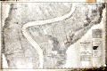 | Details | Mississippi River Commission | 1894 |
| The Mississippi River near St. James, Louisiana |
|
Mississippi River Commission |
|
| 1894 |
| LOC:0 |
| $450.00 | Mississippi-River-Commission | The-Mississippi-River-near-St--James--Louisiana | Large, very scarce, rolled survey chart or map of the Brilliant Point and College Point portions of the Mississippi River from 1894. Coverage on this antique map stretches across St. James Parish and documents numerous plantations, cultivated fields, and individual land holdings, including many with French surnames: Bonnecaze, Dernier, Bourgeois, Braud, Fabre, and Plaisance.
<br></br>
An inset index chart identifies the area as belonging to the Brilliant Point and College Point stretches of the Mississippi River, but may be more familiar as that portion of the river between Baton Rouge and New Orleans that includes the area near St. James, Louisiana and Oak Alley Plantation. No copy of this chart or any from the series are currently known to be available for sale.
<br></br>
On the North bank of the Mississippi are 3 towns: College, Donnelson, Wilton, and Hester; a race track, Jefferson College, and Sacred Heart Convent, Numerous plantations are mapped including St. Belmont Plantation, Homestead Plantation, Oneida Plantation, Uncle Sam Plantation, Wilton Plantation, Helvetia Plantation, St. Rose Plantation, St. Michael Plantation.
<br></br>
On the river's South bank lies St. Emma and a settlement referred to as "Free Town". Identified plantations on the South bank include Oak Alley Plantation, St. James Estate, Felicite Plantation, St Joseph Plantation, Home Place Plantation, Jefferson Plantation, Pikes Peak Plantation, Cabanocey Plantation, Rich Bend Plantation, Bonsecour Plantation, M.B.C. Plantation, St. Cecile Plantation, Sydney Plantation, La Pice Plantation, and St. Claire Plantation.
<br></br>
Photo lithograph produced by Julius Bien and Company. From a two volume set of 78 sheets produced by the Mississippi River Commission ca. 1896 . Detailed soundings from bank to bank at approximately 400 - 500 foot intervals. Railroads and numerous benchmarks are identified. Number 71. |