| | Thumbnail | | Creator | Date | Title / Author / Date / Location | Price | | | Description |
| 650 | 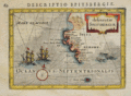 | Details | Bertius, Petrus | 1616 |
| Spitsbergen, Norway |
|
Bertius, Petrus |
|
| 1616 |
| LOC:0 |
| $0.00 | Bertius--Petrus | Spitsbergen--Norway | <br></br>
SOLD
<br></br>
Small decorative antique copperplate map of Spitsbergen, Norway by Petrus Bertius (1565-1629), a professor of mathematics and librarian from Holland. With two sailing vessels underway and penguins cavorting offshore in 'Oceanus Septentrionalis' (Northern Ocean) .
<br></br>
Probably from ''Tabularum geographicarum contractarum...' published by Jodocus Hondius in 1616. Latin text on verso. Page 60. |
| 1292 | 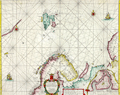 | Details | Doncker, Hendrick | 1664 |
| Antique nautical chart of Norway, Spitsbergen, Greenland, and Russia |
|
Doncker, Hendrick |
|
| 1664 |
| LOC:200 |
| $1,500.00 | Doncker--Hendrick | Antique-nautical-chart-of-Norway--Spitsbergen--Greenland--and-Russia | Scarce copper-engraved sea chart of Spitsbergen, Norway and to the west, the largely unknown shores of Greenland. by cartographer Hedrick Doncker, Amsterdam. Coverage on this very attractive antique sea chart includes "Finnmarken" (Norway), "Lapland", "Nieu Groenlandt", Jan Mayen Island, Svalbard ("Spitsbergen"), "Nova Zemla", and Russia with Arkhangelsk ("Archangel"). Shows a longer coastline for Greenland than later editions of the same map by Doncker. Dated within to 1664.
<br></br>
Hendrick Doncker (1626-1699) was an Amsterdam printer, bookseller, and cartographer residing in the Nieuwe Bruchsteegh in Stuurmans Gereetschap. |
| 367 | 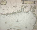 | Details | Goos, Pieter | 1664 |
| Cuften van Noorwegen |
|
Goos, Pieter |
|
| 1664 |
| LOC:0 |
| $0.00 | Goos--Pieter | Cuften-van-Noorwegen | SOLD<br></br>
Beautiful antique engraved chart of the Skagerrak with Swedish and Norwegian coast and fjords centered on Oslo. Produced by Dutch cartographer Pieter Goos in Amsterdam in 1664. <BR> </BR>
Primary coverage includes the south coast of Norway from "Der Neus" east of Kristiansand, past Oslo fjord to Pater Nosterskärgårdens naturreservat on the southwest coast of Sweden. Slight coverage of northwest Jutland includes Skagen. Place names on this antique nautical chart are in Dutch so matching place names to their current equivalent is challenging: Anfloo = Oslo; Tonfberger = Tonsberg; Laerwyck = Larvik; Schagen = Skagen; Trom = Tromoy; Vlecker = Flekkerøy. Most other place names difficult (for me) to identify. Other unknown cities include Coperwyck, Akershuys, De Buy, Hefnes . Plate number 8.<BR> </BR>
Probably derived from the earlier work by Willem Janszoon Blaeu in 1619. |
| 1150 | 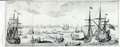 | Details | Narbrough, John | 1694 |
| Early 17th century engraved whaling scene |
|
Narbrough, John |
|
| 1694 |
| LOC:1 |
| $300.00 | Narbrough--John | Early-17th-century-engraved-whaling-scene | Early foldout engraved bookplate (1697) depicting a whaling scene to illustrate Friedrich Martens' observations on northern whaling. Attractive antique print shows multiple whaling ships and ships boats engaged in harpooning, fighting, and flensing whales. A fine gift.
<br></br>
The view lends insight into the methods used to hunt whales in the early 17th century in the whaling grounds of the far northern latitudes like Greenland and the island of Spitsbergen, Norway. For example the ship at far right is shown tied off to an iceberg, a practice noted by Narbrough in the text. <div class="indenttextblock"> "When they sail some Miles into the Ice, where there is pretty large Ice-fields, they joyn their Ships to them with great Ice-hooks, fastned to strong Cables, where they lie at Anchor, several Ships about the same Ice-field, but they rather chose to be alone, because they are an hindrance to one another in Whale catching, and the hunting of them from one to another maketh them shie. (Online: http://darwin-online.org.uk/converted/Ancillary/BeagleLibrary/1694_Narborough_A813.html")</div>
</br>
Originally published in 1694 to accompany "The First Part of the Voyage into Spitsbergen and Greenland.", this record of recent voyages made by Sir John Narborough, Abel Tasman, John Wood and Friderich Martens. Narborough's journal records his voyage to the Straits of Magellan and his interest in the lands and peoples he encountered from 1669 to 1671.
<br></br>
This fine antique print illuminates Friedrich Martens' (1635 - 1699) observations on Spitsbergen and whaling in northern waters in 1671. |
| 574 |  | Details | Homann, Johann | 1720 |
| Regni Norvegiae Accurata Tabula |
|
Homann, Johann |
|
| 1720 |
| LOC:57 |
| $500.00 | Homann--Johann | Regni-Norvegiae-Accurata-Tabula | Decorative copper-plate engraved antique map of Norway by Johann Baptist Homann (1664-1724) . Homann was a profilmic German cartographer and publisher who was appointed cartographer to the Holy Roman Empire from 1715.
<br></br>
After Homann's death his maps were re-published by his heirs. Homann Heirs (also "Homannianis Heredibus" or "Homann Erben" or "Heritiers de Homann") was a company established after the death of Homann to carry on the publishing business of the firm he started in the early 1700's. The designation "Homann Heirs" appears on maps published by that successor firm from about 1730 to 1848. This antique map does not carry that designation but probably dates to ca. 1742 - 1748.
<br></br>
At bottom left of the map is a highly decorative title cartouche containing the Norwegian state coat of arms, a lion bearing an axe. Beneath that emblem are depicted numerous nymphs cavorting in the sea. |
| 2562 | 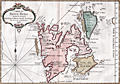 | Details | Bellin, Jacques Nicolas | 1758 |
| Antique French map of Spitsbergen, Norway |
|
Bellin, Jacques Nicolas |
|
| 1758 |
| LOC:88 |
| $270.00 | Bellin--Jacques-Nicolas | Antique-French-map-of-Spitsbergen--Norway | Fine 18th-century antique French map of Spits-berg (Spitsbergen), in today's Svalbard Islands - in northern Norway; the largest Norwegian island. One of the most northern regions to be discovered by Europeans, the place names seen here reflect the nationalities of those early travellers, English, Dutch, Scandinavian and French. Spitsbergen was first used as a whaling base in the 17th and 18th centuries.
<br></br>
The first known sighting of Spitsbergen by a European was by Willem Barentsz, who came across it in 1596 while searching for the Northern Sea Route.
<br></br>
Published in a French edition of L'Abbe Prevost's "Histoire Générale des Voyages", less than twenty years before Captain Cook's famous voyage. Page 192. Book 17. |