| | Thumbnail | | Creator | Date | Title / Author / Date / Location | Price | | | Description |
| 284 | 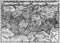 | Details | Magini, Giovanni Antonio | 1598 |
| Descrittione di Tutto'l Mondo, Secondo la prattica de' Marinari |
|
Magini, Giovanni Antonio |
|
| 1598 |
| LOC:6 |
| $850.00 | Magini--Giovanni-Antonio | Descrittione-di-Tutto-l-Mondo--Secondo-la-prattica-de--Marinari | Exquisitely-engraved small antique chart of the entire world by Tolomeo Magini executed in the style one would find in larger sea charts of the late 16th century, with rhumb lines. At the time the copperplate engraving was made the outlines of the continents were becoming more accurate. This chart reflects those cartographic achievements with the glaring exception of a large southern landmass "Terra Australis Nondum Cognita", which stretches from West to East at the chart bottom. Much finely engraved detail and calligraphy by Porro with stippling throughout all the world's oceans and seas.<BR> </BR>
5" x 7" engraving set in a larger sheet of Italian text measuring 8" x 12". <BR> </BR>
Verso contains text descriptions of Caribbean islands with large woodcut capitals. These descriptions include the islands of Jamaica (L' Isola Iamaica, o di S. Iacomo), Cuba (L' Isole Cuba, o Fernandina) and Canibalori (L'Isole de Canibalori, o de Caribi). Overall a very interesting piece. Chapter 35. |
| 102 | 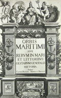 | Details | Morisot, C.B. | 1643 |
| Title Page Orbis Maritimi |
|
Morisot, C.B. |
|
| 1643 |
| LOC:50 |
| $200.00 | Morisot--C-B- | Title-Page-Orbis-Maritimi | Decorative antique title page from the first comprehensive work on maritime history by Charles Barthelemy Morisot (1592-1661) - "Orbis Maritimi siue Rerum".
<br></br>
This rare engraving is adorned with sea shells, anchors, and implements of war. Petrum Palliot, 1643. First and only edition. |
| 6773 |  | Details | Moll, Herman | 1715 |
| Moll's world map of with monsoons and trade winds |
|
Moll, Herman |
|
| 1715 |
| LOC:89 |
| $400.00 | Moll--Herman | Moll-s-world-map-of-with-monsoons-and-trade-winds | Increasingly scarce map of the world by Herman Moll ca. 1715 covering a large area from 50 degrees north to 50 degrees south of the Equator. The map, on Mercator's projection is centered on "the Great South Sea", or Pacific Ocean, and Moll's incomplete outlines for New Zealand, Australia, and Tasmania reflect the uncertain state of geographical knowledge in the early eighteenth century.
<br><br>
Moll's maps touching on compass variation and wind patterns, especially the trade winds, stand out as significant contributions to cartography and navigation. Moll tried to visualize the concept of global atmospheric circulation, making use of the contemporary understanding of trade winds and monsoons. Monsoon winds are seasonal wind patterns that occur over various regions, most notably in South and Southeast Asia, where they cause the well-known monsoon rains. As Moll explains in his note at upper left:
<br><br>
<div class="indenttextblocksingle">
"Note that the Arrows among the Lines shew the Course of these General & Coasting Winds, and the Arrows in the void Spaces shew the Course of the Shifting TRADE-WINDS, and the abbreviations Sept. &c. Shew the Times of the Year when such Winds blow".
</div><br>
<div id="0" align="center">
<a title=""></a>
<img id="6773" src="/ZoomifyImages/SC_6773/SC_6773_detail_1.jpg" alt="Detail of the East Indies from Moll's Map of Monsoon and Trade Winds." width="340"/> <br><br> <font size="-2">Monsoon and Trade Winds in The East Indies. Moll, 1715.</font>
</div><br>
On this map, Moll represented the trade winds – the predictable east-west wind patterns in the tropical latitudes – using arrows. Knowing the direction of the trade winds at specific times of the year, was crucial to understanding how to plan routes for ships involved in trade and exploration. This information was invaluable to the burgeoning Atlantic economies, particularly in the context of the Atlantic triangular trade. |
| 4755 | 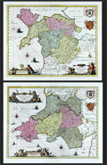 | Details | Jansson, Jan | 1720 |
| Fine pair (2) of antique maps of North Wales and South Wales. |
|
Jansson, Jan |
|
| 1720 |
| LOC:64 |
| $1,100.00 | Jansson--Jan | Fine-pair-(2)-of-antique-maps-of-North-Wales-and-South-Wales- | Pair of beautiful antique maps of North and South Wales in the United Kingdom ca. 1720. Fine condition. Both maps are filled with charming pictorial topography describing forests, cities, and mountains. Published in Amsterdam by Pieter Schenk and Gerard Valk after Joannes Janssonius (Jan Jansson).
<br></br>
Locations within Wales include Glamorgan, Carmarthen, Pembroke, Brecon, Cardigan, Radnor in South Wales and Snowdown Hill (Snowdon) in North Wales, the highest mountain in the country. Both maps are adorned with superb engraved aquatic cartouches adorned with putti, coats of arms and sailing ships. Blank verso. Attribution at bottom to Shenk and Valk, Amsterdam, publishers. |
| 5238 | 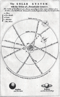 | Details | London Magazine | 1752 |
| Antique engraved plate of the Solar System and comets |
|
London Magazine |
|
| 1752 |
| LOC:0 |
| $150.00 | London-Magazine | Antique-engraved-plate-of-the-Solar-System-and-comets | Original antique copper-plate engraved view titled: "The solar system with the orbits of 5 remarkable comets." The print explains the drawing:
<div class="indenttextblocksingle">
"The orbits of the Planets are drawn according to their mean distance from the Sun; and the Planets themselves in the proportions they bear to each other."
</div></br>
Illustrates the Copernican heliocentric theory of the solar system. Interesting representation of five periodic appearances of comets with their periodicity and generalized orbits.
<br></br>
Published in the February, 1752 issue of London Magazine to illustrate an article: "The Solar System according to Copernicus." |
| 1126 | 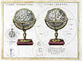 | Details | Le Rouge, George | 1760 |
| Terrestrial and celestial globes |
|
Le Rouge, George |
|
| 1760 |
| LOC:0 |
| $180.00 | Le-Rouge--George | Terrestrial-and-celestial-globes | Antique old French copper-plate engraving ca. 1748 of two globes: a terrestrial globe and a celestial globe. A celestial globe is a spherical representation of the celestial sphere, showing the apparent positions of the stars and constellations in the sky. The engraving includes additional representations: of the points of the compass, a solar eclipse, lunar eclipse, and the relative sizes of the astronomical bodies.
<br></br>
From le Rouge's "Atlas Nouveau Portatif à l'usage des militaires et du voyageur" published from Paris. George Le Rouge was a Paris-based engineer and surveyor originally from Germany who had a shop on the Rue Des Grands Augustins. Le Rouge's tireless work earned him the title "Geographe du Roi". |
| 176 |  | Details | Bellin, Jacques Nicolas | 1765 |
| Carte des Variations de la Boussole |
|
Bellin, Jacques Nicolas |
|
| 1765 |
| LOC:0 |
| $0.00 | Bellin--Jacques-Nicolas | Carte-des-Variations-de-la-Boussole | NOT AVAILABLE <BR> </BR> Spectacularly decorative antique nautical map of the World from the 'Hydrographie francoise' by Jacques Bellin. Displays compass variation and prevailing wind direction across the globe. Australia is shown with only a partial coastline as "Terres Australis" or "Nouvelle Hollande" and the U.S. Pacific Northwest with no coastal detail.<BR> </BR>
Winds are represented as small cherubs with puffed cheeks. Huge rococo cartouche at right is decorated with cornucopia and numerous floral elements; capped with a crowned globe bearing the three fleur-de-lis that have been an emblem on the French coat of arms from the 14th century. This antique map of the world was produced by J.N. Bellin, the first French "Ingenieur de la Marine" towards the end of his career in 1765. The dedicatory cartouche to the Minister of War, the Duke de Choiseul, is as much a tribute to Bellin as to the minister as it lists his several accomplishments: "Ingenieur de la Marine", "Censeur Royal de l'Academie de Marine et de la Societe Royale de Londres". |
| 1124 | 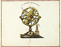 | Details | Anonymous | 1777 |
| Ptolemaic armillary sphere |
|
Anonymous |
|
| 1777 |
| LOC:1 |
| $100.00 | Anonymous | Ptolemaic-armillary-sphere | Finely engraved Ptolemaic armillary sphere. This early engraving served as the source for a later similar image with celestial and terrestrial globes, published by Citoyen (Citizen) Berthelon in Paris ca. 1799, for the "Nouvelle Edition" of the Atlas Modern Portatif.
<br></br>
An armillary sphere is a model of objects in the sky consisting of a spherical framework of rings, centered on the Earth or the Sun, that represent lines of celestial longitude and latitude and other astronomically important features such as the ecliptic. As such, the armillary sphere differs from a celestial globe, which is a smooth sphere whose principal purpose is to map the constellations.
<br></br>
With the Earth at the center, an armillary sphere is known as a Ptolemaic sphere. With the sun at center, it is known as a Copernican sphere. |
| 525 | 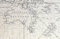 | Details | Depot de la Marine | 1818 |
| Carte Reduite du Grand Ocean comprise L'Asie et L'Amerique |
|
Depot de la Marine |
|
| 1818 |
| LOC:0 |
| $0.00 | Depot-de-la-Marine | Carte-Reduite-du-Grand-Ocean-comprise-L-Asie-et-L-Amerique | SOLD
<br><br/>
Antique rare 'brown-back' navigation chart issued by the French Depot de la Marine in 1818. Coverage extends from Sumatra in the far west to the Antilles and Gulf of Mexico. Includes: Vietnam, Korea, Philippines, Japan, Australia (Nouvelle Hollande), New Zealand, the "Sandwich Islands" [Hawaii (Owhywi) , Mowi, Oahu (Woahua)...], Easter Island (Isle de Paques), Port St Francois (San Francisco), California and most of the Pacific Islands. <br><br/>
With the circular stamp of the Depot General de la Marine at bottom left. Chart is covered with brown linen; probably contemporary to its issue based on the wear pattern. No. 420. Price 2 Francs. |
| 1280 |  | Details | Brue, Adrien Hubert | 1822 |
| Large antique world map of the east and west hemispheres. |
|
Brue, Adrien Hubert |
|
| 1822 |
| LOC:0 |
| $0.00 | Brue--Adrien-Hubert | Large-antique-world-map-of-the-east-and-west-hemispheres- | Sold
<br></br>
Attractive large antique dual-hemisphere map of the world by Adrien Brue. Presented as two joined views of the eastern and of the western hemispheres. Nice and careful hand-coloring. |
| 110 |  | Details | Norie, J.W. | 1840 |
| A Complete Epitome of Practical Navigation |
|
Norie, J.W. |
|
| 1840 |
| LOC:0 |
| $0.00 | Norie--J-W- | A-Complete-Epitome-of-Practical-Navigation | SOLD <BR> </BR>
Twelfth edition of this British nautical standard. |
| 6667 |  | Details | Perry, Heather "Herry" | 1930 |
| Rare Art Deco map puzzle Imperial and International Communications Ltd |
|
Perry, Heather "Herry" |
|
| 1930 |
| LOC: |
| $0.00 | Perry--Heather-"Herry" | Rare-Art-Deco-map-puzzle-Imperial-and-International-Communications-Ltd | <br><br>This item has found a new home with a very serious west-coast collector, but please visit <a href="https://www.rarecharts.com/ShowDetail/Creator/Perry--Heather-%22Herry%22/Title/Rare-Art-Deco-Imperial-and-International-Communications-Ltd-Map-Puzzle/6724" target="_blank">another example of Herry Perry's beautiful puzzle map</a> now in RareCharts' inventory for only the second time in 13 years.
<br><br>
Fine 3-ply wooden promotional map puzzle, created during the Golden Age of pictorial maps for Imperial and International Communications Ltd. (IICL) by the Chad Valley Company. Designed by Herry Perry, London in 1930. Complete with all ~150 pieces. Includes the original cardboard box, which was manufactured in Holland.
<br><br>
<div id="0" align="center">
<a title="TITLE HERE"></a> <img id="3" src="/zoomifyimages/SC_6667/SC_6667_Box.jpg" alt="Herry Perry map puzzle for Imperial and International Communications Ltd, 1930, London." width="300"/> <br><small>Original box for Herry Perry's IICL map puzzle.</small>
</div><br>
This fine Art Deco style map of the IICL network predates McDonald Gill's Cable and Wireless Great Circle map by 15 years (1945). Art Deco style characters represent the Anemoi or mythological Roman wind Gods (Boreas, Zephyrus, Notus, and Eurus)) and the Greek wind gods, or Venti (Aquilo, Favonius, Auster, and Vulturnus). Green lines mark the cables of the I and ICL and the dotted green lines their wireless.
<br><br> |
| 6724 |  | Details | Perry, Heather "Herry" | 1930 |
| Rare Art Deco Imperial and International Communications Ltd Map Puzzle |
|
Perry, Heather "Herry" |
|
| 1930 |
| LOC:500 |
| $3,500.00 | Perry--Heather-"Herry" | Rare-Art-Deco-Imperial-and-International-Communications-Ltd-Map-Puzzle | <br></br>Bring a piece of British telecommunications history to your collection. This exquisite, complete, and rare Art Deco style puzzle map of the Imperial and International Communications (IICL) network ca. 1930 precedes McDonald Gill's Cable and Wireless Great Circle map by 15 years and features elegant characters representing the Anemoi, mythological Roman wind gods, and the Greek wind gods or Venti: Boreas, Zephyrus, Notus, Eurus, Aquilo, Favonius, Auster, and Vulturnus. Green lines indicate the undersea cables of the IICL, while dotted green lines signify IICL wireless transmissions.
<br><br>
<div id="0" align="center">
<a title="Perry's Telecom Map Puzzle"></a> <img id="3" src="/zoomifyimages/SC_6724/SC_6724_Detail.jpg" alt="Art Deco details from Herry Perry map puzzle for Imperial and International Communications Ltd, 1930, London." width="350"/> <br><small>Detail from Herry Perry's Art Deco IICL map puzzle, 1930.</small>
</div><br>
The map was designed by Herry Perry and manufactured as a promotional item for the IICL, by the Chad Valley Company, an eminent English toy manufacturer . The Chad Valley Company was active from 1860 to 1978. Its products ranged from high-quality soft toys, educational puzzles, board games, to construction sets.
<br></br>
In 1929, the Imperial Telegraphs Act paved the way for the formation of two new companies that would merge the various telegraph and wireless services within the British Empire and create a coordinated global communications network. Initially, IICL focused on expanding its services within the British Empire, but it eventually expanded its coverage to other regions like the Middle East, Africa, and Asia. IICL merged with Cable & Wireless Limited in 1934. Includes the intact original puzzle box.
<br><br>
Don't miss out on the opportunity to own a rare and remarkable piece of British telecommunications history - purchase this Art Deco map puzzle of the IICL network today. |
| 6683 |  | Details | Western Union | 1930 |
| Transatlantic Cables Western Union Thematic World Bathymetric Chart Art Deco |
|
Western Union |
|
| 1930 |
| LOC:150 |
| $0.00 | Western-Union | Transatlantic-Cables-Western-Union-Thematic-World-Bathymetric-Chart-Art-Deco | SOLD<br><br>
Scarce thematic map of the world with Western Union's routes for underwater telegraphy cables (1) between Western Europe and the United States during the period between the wars. Dated circa 1930 based on the attention given to the Art-Deco style Western Union Building in N.Y.C. that was built in 1930. Sub-title notes Western Union key communications nodes between France, Holland, Germany, and Great Britain to New York, Boston, Washington, Montreal, and Toronto.
<br><br>
<div id="0" align="center">
<a title="Western Union Communications Network Nodes in 1930"></a>
<img id="3" src="/ZoomifyImages/SC_6683/SC_6683_Detail.jpg" alt="Thematic world map Western Union's underwater telegraphy cable network in 1930." width="320"/> <br><small>Western Union Communications Network Nodes. 1930.</small>
</div>
<br>
The main focus of the work is a 1930 snapshot of Western Union's wireless network (dashed red lines) and the cable network, shown (solid red lines) overlayed on a bathymetric chart with a bird's eye view of the ocean floor (if birds had x-ray vision). The bathymetric chart is surrounded with text and images relating to cable-laying ships including the Great Eastern (2).
<br><br> |
| 6374 |  | Details | British Israel World Federation | 1930 |
| Unusual map depicting British Empire derived from the Lost Tribes of Israel. |
|
British Israel World Federation |
|
| 1930 |
| LOC:4 |
| $250.00 | British-Israel-World-Federation | Unusual-map-depicting-British-Empire-derived-from-the-Lost-Tribes-of-Israel- | Scarce map of the British Empire by the British-Israel-World Federation a United Kingdom-based organization which promotes British Israelism, the belief that the people of the British Isles are descendants of the Ten Lost Tribes of ancient Israel.
<br></br>
Map after "The World on Mercator's Projection Showing the British Empire 1924." With a small card-stock folder and a card containing an image of the Coronation Chair, Westminster Abbey. Folder is titled: "Set of Pamphlets bearing on British-Israel-World Federation. With the compliments of the Salisbury Branch of the British-Israel-World Federation Publishers of The National Message, 2d." |
| 88 |  | Details | Wilson, Elen | 1937 |
| The Story of the Blueback Chart |
|
Wilson, Elen |
|
| 1937 |
| LOC:2001 |
| $65.00 | Wilson--Elen | The-Story-of-the-Blueback-Chart | Booklet contains a brief history and chronology of the old chart publishing firm of Imray as far back as John Seller and John Senex. Self-published complimentary brochure with softcover and string binding. 20 pages plus illustrations. |
| 6705 | 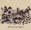 | Details | John Player and Sons | 1938 |
| Unrecorded thematic pictorial tobacco advertising map |
|
John Player and Sons |
|
| 1938 |
| LOC:40 |
| $1,000.00 | John-Player-and-Sons | Unrecorded-thematic-pictorial-tobacco-advertising-map | Fine unrecorded advertising world map "Tobacco" published by John Player and Sons (1) circa 1938 (2). The map shows graphically the sources where tobacco was grown as well as shipping routes for tobacco cargos to England. Inset tables for: the four methods of curing tobacco; and the United Kingdom's principal sources of supply of different types of tobacco. Sketches at top and bottom of the map show the various steps in the growth, shipment, and preparation of Player's various tobacco products including cigarettes.
<br><br>
Not found in WorldCat. No example or record of a sale of the Tobacco map is found online.
<br><br> |
| 4846 | 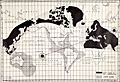 | Details | Zingg, Andrew | 1939 |
| Map of the Future by Andrew Zingg |
|
Zingg, Andrew |
|
| 1939 |
| LOC:0 |
| $0.00 | Zingg--Andrew | Map-of-the-Future-by-Andrew-Zingg | SOLD
<br></br>
A work, not of the display of quantitative information, but of pure imagination. Visually depicts Andrew Zingg's personal, apocalyptic "inspirational vision" for a transformative change of the Earth's surface and magnetic poles. The map was almost certainly self-published, a vanity map.
<br></br>
No other copy of this map is found anywhere on this planet.
<br></br>
By Andrew Zingg (1868-1954) of Wilton Junction, Iowa. 1939. The online Catalog of Copyright Entries shows that a copyright was granted to Andrew Zingg on January 21, 1939 for a "Map of Future Events".
<br></br>
Zingg's vision is documented in an included two-page typed letter titled: "A New Map of the World (There will be a Cycle Change of this Globe in the Near Future.)" The explanation defines the results of Zingg's hypothesis for imminent change in the earth's magnetic field along with climate changes and massive changes in the earth's landmass that might be expected with extreme tectonic forces.
<br></br>
<div class="indenttextblocksingle">
"We are now living in that age in which a physical change of the Globe will soon occur in which this world will roll (in its orb) to a new point of balance which will swing its axis unto new moorings, the North Pole will be shifted into Siberia east of the Ural Mountains and the South Pole in the South Pacific Ocean."
</div>
<br></br>
Contains blue ink hand-stamps referencing Zingg's copyright in 1939. Zingg signed his letter cryptically with "(A - Z - Alpha Omega)". Note: map is much larger that the two typed pages (not to same scale). |
| 5385 | 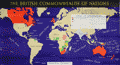 | Details | British Information Services | 1942 |
| Fine pictorial WWII-era map of the British Commonwealth of Nations |
|
British Information Services |
|
| 1942 |
| LOC: |
| $300.00 | British-Information-Services | Fine-pictorial-WWII-era-map-of-the-British-Commonwealth-of-Nations | Fine pictorial world map showing the British Commonwealth of Nations. Issued during WWII by the British Information Services, an agency of the British Government. Mercator projection.
<br></br>
Includes two inset tables:<br>
1) "Forms of Government". This key uses color to signify the form of government administration and management of internal and external affairs. <br>
2) "Principal Products". A tabular representation by geographical area uses pictograms to represent the most valuable products produced in the Commonwealth.
<br></br>
Distributed by the British Information Services, an agency of the British Government, 30 Rockefeller Plaza, New York. Printed in England. |
| 5474 | 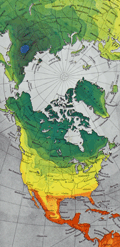 | Details | Fuller, R. Buckminster | 1954 |
| Dymaxion Airocean World Map Raleigh edition signed in manuscript by Fuller. |
|
Fuller, R. Buckminster |
|
| 1954 |
| LOC:150 |
| $0.00 | Fuller--R--Buckminster | Dymaxion-Airocean-World-Map-Raleigh-edition-signed-in-manuscript-by-Fuller- | SOLD <br><br>Scarce original offset-lithographed <strong>Dymaxion Airocean World map by R. Buckminster Fuller </strong> and Shoji Sadao [1]. From the "Raleigh Edition", (1954) of 3,000 copies. Red stamped sheet number "0138". Published by the Student Publications of the School of Design, North Carolina State University, Raleigh, N.C. Verso blank.
<br></br>
R. Buckminster Fuller's Dymaxion map projection is a method of projecting the spherical Earth onto a folded twenty-sided polyhedron known as an icosahedron. Fuller intended the map to be unfolded in different ways to emphasize different aspects of the world. This Dymaxion map displays mean annual low temperature.
<br></br>
An earlier version of Fuller's projection based on a cuboctahedron was featured in the March 1, 1943 edition of Life magazine. Titled “Life Presents R. Buckminster Fuller’s Dymaxion World”, the article included a pull-out section that could be assembled as a three-dimensional model.
<br></br>
Manuscript dedication to Carroll Williams signed "Buckminster Fuller" dated to June 1, 1956. From 1951-1954 Carroll Williams taught graphic arts at Black Mountain College, then in Black Mountain, NC Carroll collaborated with Buckminster Fuller on Geodesics, Inc. in Raleigh, NC during 1956-1957.
<br></br>
At bottom right is a pasted label with the return address for A.H. Fuller at 3013 Hillsboro Street. Here, A.H. Fuller is Fuller's wife Anne Hewlett Fuller d. 1983.
<br></br>
Includes a second large sheet with explanatory diagrams and text explaining the Dymaxion Airocean World Fuller Projective-transformation. U.S. Patent 2,393,676.
<br></br>
[1] Shoji Sadao (1927- 2019) Cartographer for the United States Army during WWII. Met Buckminster Fuller in the early 1950's while studying architecture at Cornell. Collaborated with Fuller in Raleigh, NC to draw the Dymaxion Airocean World map in 1954. |
| 6811 | 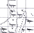 | Details | Maury, Matthew Fontaine | 1956 |
| Matthew Maury's Whale Chart Third Ed |
|
Maury, Matthew Fontaine |
|
| 1956 |
| LOC:68 |
| $1,900.00 | Maury--Matthew-Fontaine | Matthew-Maury-s-Whale-Chart-Third-Ed | Rare world-wide thematic chart of reported whale sightings by Matthew Fontaine Maury. Provides data on whale sightings by season, geographic area, whale species, and relative frequency. First published in 1851 but this 3rd edition re-issued in 1956 by the U. S. Navy Hydrographic Office.
<br><br>
Maury's Whale Chart provided valuable information about the migratory patterns of various whale species based on data collected from whalers and merchant ships and depicted the seasonal movements of different whale species in the Atlantic and Pacific Oceans. It included information about the regions where whales were most commonly found during specific times of the year, helping whalers optimize their efforts and increase their chances of successful hunts.
<br><br>
The last three editions of Maury's Whale Chart may be identified thus:
<div class="indenttextblocksingle">
<ul style="list-style-type: circle;">
<li><b>Third Edition (1956)</b></br>
Upper top left position with logo of eagle clutching items in claws surrounded by text: "Hydrographic Office U.S. Navy". Top right position is blank. Bottom right position reads "Price 20 cents / H.O. Miscel. No. 8514".</li>
<li><b>Fourth edition (1960)</b></br>
Upper top left position with logo of eagle over an anchor surrounded by text: "United States Hydrographical Office". Top right position reads "Catalog: Introduction. Part 1.". Bottom right position reads "Price 50 cents / H.O. Miscel. No. 8514" .
</li>
<li><b>Fifth edition (after 1972)</b></br>
Upper top left with logo containing an eagle perched on a globe with text "Defense Mapping Agency". Top right position reads "Catalog P2V10". Bottom right reads "Lith of Wm. Endicott & Co. N. York | 5018 | DMA Stock Number | W0XZC5018.</li>
</ul>
</div> |
| 2494 | 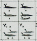 | Details | Maury, Matthew Fontaine | 1956 |
| Maury's Whale Chart 3rd. Ed |
|
Maury, Matthew Fontaine |
|
| 1956 |
| LOC:0 |
| $0.00 | Maury--Matthew-Fontaine | Maury-s-Whale-Chart-3rd--Ed | SOLD
<br></br>
Rare thematic chart of reported whale sightings by geographic area, whale species, and relative number of sightings.
<br></br>
Third issue (of four). Hydrographic Office of the US in the mid 20th century. Upper top left position with logo of eagle clutching items in claws surrounded by text: "Hydrographic Office U.S. Navy". Top right position is blank. Bottom right position reads "Price 20 cents / H.O. Miscel. No. 8514" Mid-20th-century electrotype on wove paper. This instance of Maury's whale chart carries a blue ink over-stamp from the U.S. Naval Supply Depot at Scotia, NY. "Corrected through Notice to Mariners No. 25 June 23, '56" that is- 1956. |
| 4935 | 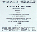 | Details | Maury, Matthew Fontaine | 1960 |
| Maury's Whale Chart 4th Edition |
|
Maury, Matthew Fontaine |
|
| 1960 |
| LOC:0 |
| $0.00 | Maury--Matthew-Fontaine | Maury-s-Whale-Chart-4th-Edition | SOLD
<br></br>
Rare thematic chart of reported whale sightings by geographic area, whale species, and relative number of sightings. An early example of the graphical display of quantitative information for decision making.
<br></br>
Matthew Maury's Whale Chart, was first issued by the United States Bureau of Ordnance & Hydrography in 1851. This is the fourth (4th.) edition, from the United State Hydrographical Office in the 1960s.
<br/></br/>
Upper top left position with logo of eagle over an anchor surrounded by text: "United States Hydrographical Office". Top right position reads "Catalog: Introduction. Part 1.". Bottom right position reads "Price 50 cents / H.O. Miscel. No. 8514" Mid-20th-century electrotype on wove paper. This instance of Maury's whale chart carries two unknown blue ink accession hand stamps in the far bottom right margin: "June 23, 1969." and "Accession no. [in MS] 763."
<br></br>
Shows best whaling areas and migration patterns for sperm whales and right whales, as well as the most densely populated areas and areas of "Straggling" Sperm Whales and Right Whales. |
| 5438 | 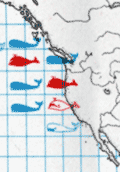 | Details | FAO United Nations | 1970 |
| Map of the world distribution of sperm and baleen whale catches |
|
FAO United Nations |
|
| 1970 |
| LOC:78 |
| $200.00 | FAO-United-Nations | Map-of-the-world-distribution-of-sperm-and-baleen-whale-catches | Scarce map of the number of catches of sperm whales and of baleen whales worldwide. From the "Atlas of the living resources of the seas" a publication of the Department of Fisheries for the <strong>Food and Agricultural Organization of the United Nations [1]</strong>.
<br><br>
Updating Maury one hundred years earlier, the color of whale pictographs are used to represent whale species. Location, and catch quantity also are represented on this chart of the world. Maury's chart reported whale sightings for sperm, baleen, and right whales, while this chart displays data on actual catches only of sperm and baleen whales.
<br></br>
[1] Online. Atlas of the living resources of the ses. United Nations FAO. http://www.fao.org/geonetwork/srv/en/metadata.show?id=9505&currTab=simple
<br></br>
(Atlas des resources biologiques des mers; Atlas de los recursos vivos del mar) |
| 5420 | 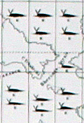 | Details | Maury, Matthew Fontaine | 1972 |
| Maurys Whale Chart 5th Edition |
|
Maury, Matthew Fontaine |
|
| 1972 |
| LOC:0 |
| $1,500.00 | Maury--Matthew-Fontaine | Maurys-Whale-Chart-5th-Edition | Scarce official U.S. thematic chart of reported whale sightings by geographic area, whale species, and relative number of sightings (5th ed. ca. 1972). An early example of the graphical display of quantitative information for decision making. The chart shows the best whaling areas and migration patterns for sperm whales and right whales, as well as the most densely populated areas of "Straggling" Sperm Whales and Right Whales." Chart # 5018.
<br></br>
Matthew Maury's Whale Chart, was first issued by the United States Bureau of Ordnance & Hydrography in 1851. This is the official U.S. fifth (5th.) edition, from the United States Defense Mapping Agency Hydrographic/Topographic Center in the 1970s. The DMA existed from 1972 through 1996. The first edition of Maury's Whale Chart is extremely rare on the market. Only one sale of Maury's chart is recorded in the Antique Map Price Record.
<br/></br/>
The last three editions of Maury's Whale Chart may be identified thus:
<div class="indenttextblocksingle">
<ul style="list-style-type: circle;">
<li><b>Third Edition (1956)</b></br>
Upper top left position with logo of eagle clutching items in claws surrounded by text: "Hydrographic Office U.S. Navy". Top right position is blank. Bottom right position reads "Price 20 cents / H.O. Miscel. No. 8514".</li>
<li><b>Fourth edition (1960)</b></br>
Upper top left position with logo of eagle over an anchor surrounded by text: "United States Hydrographical Office". Top right position reads "Catalog: Introduction. Part 1.". Bottom right position reads "Price 50 cents / H.O. Miscel. No. 8514" .
</li>
<li><b>Fifth edition (after 1972)</b></br>
Upper top left with logo containing an eagle perched on a globe with text "Defense Mapping Agency". Top right position reads "Catalog P2V10". Bottom right reads "Lith of Wm. Endicott & Co. N. York | 5018 | DMA Stock Number | W0XZC5018.</li>
</ul>
</div> |
| 6678 |  | Details | U.S. Coast Guard | 1972 |
| Coast Guard Poster worldwide locations |
|
U.S. Coast Guard |
|
| 1972 |
| LOC:86 |
| $145.00 | U-S--Coast-Guard | Coast-Guard-Poster-worldwide-locations | Decorative old-stock promotional poster ca. 1973 (1) with the locations of the U.S. Coast Guard around the world, or at least the western world. Executed with elements of 70's style reflecting the influence of the counter-culture on the arts during that period. With the Coast Guard motto : Semper Paratus or Always Ready.
The map omits any locations in Asia, where during that time period there was a war raging in Vietnam. Reminding the viewer of that overseas duty station was probably not conducive to the CG recruiting effort in '73.
<br><br>
Legend at bottom lists the activities and programs the U.S. Coast Guard engaged in including:
<div class="indenttextblocksingle">
<ul style="list-style-type: circle;">
<li>Icebreaking</li>
<li>Iceberg Patrol</li>
<li>Fisheries Conservation</li>
<li>Radio Navigation</li>
<li>Port Safety Vessel Traffic System</li>
<li>Search and Rescue</li>
<li>Aids to Navigation</li>
<li>Law Enforcement</li>
</ul>
</div>
(1) We have dated the map with reference to the planned Omega Station shown on the continent of Australia. Planning for that station was underway as early as 1972 when the Australian Department of Shipping and Transport was making a final site selection decision. The Omega Navigation System was a global radio navigation system that operated from 1971 to 1997. It consisted of eight ground-based stations, including three in Alaska, that transmitted signals in the VLF (Very Low Frequency) range to provide accurate navigation information for ships and aircraft. The Omega Navigation System was eventually replaced by more modern and precise satellite-based navigation systems such as GPS (Global Positioning System)
<br><br>
Document ID: G-PMR30 |
| 5472 | 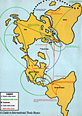 | Details | High Times | 1985 |
| Late 20th C map of International Drug Production |
|
High Times |
|
| 1985 |
| LOC:87 |
| $225.00 | High-Times | Late-20th-C-map-of-International-Drug-Production | Thematic, pictorial, world map focused on the agricultural and manufacturing/refining sites that produced illegal drugs in the mid 1980's. A two-page "Bonus Centerfold" to a 1985 issue of <i>High Times</i> a monthly drug-oriented, counterculture magazine published by Trans-High Corporation of Farmingdale, N.Y. Robert Aronson, publisher. Perfect for collectors, dispensary decoration, or nostalgic old hippies.
<br></br>
This fine, increasingly scarce, original map <strong>"The World According to Dope: A Guide to International Drug Production"</strong> shows locations for growing coca, pot, poppies, and khat as well as of laboratories for production of cocaine, heroin amphetamine, and more all explained in a legend near bottom center using simple easily-understood pictographs to represent each drug. Notations on the map supplement the location information with a few interesting tidbits, (e.g., "Ukrainian ditchweed", "Bahamas and Turks and Caicos Islands: one big money laundry".)
<br></br>
Verso with a single-page map <strong> "Guide to International Trade Routes" </strong>for heroin, marijuana, Quaaludes, Cocaine, and khat. Most destinations are located on the map in the United States or in Europe. Polar projection. |
| 5486 | 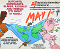 | Details | Revolutionary Worker | 1991 |
| Communist Party protest cover poster cartographic propaganda |
|
Revolutionary Worker |
|
| 1991 |
| LOC:87 |
| $325.00 | Revolutionary-Worker | Communist-Party-protest-cover-poster-cartographic-propaganda | Slogan-oriented cover from Revolutionary Worker, a publication "Voice of the Revolutionary Communist Party, USA." Scarce late 20th-century Communist propaganda (1991) depicting the "Rulers of America" as pigs.
<br></br>
Another propagandistic use of a world map with North America depicted tilted aggressively to the east as Russia tilts west in the direction of the U.S.A., a distortion permitted by the unusual projection of the world enabled by the map's use of map as tablecloth metaphor. Tumbling pigs to right disguise the true intent of this 1991 International Workers Day cover. Handcuffs, cash, missiles, jets, and artillery pieces represent the existing Racists and Rambo-Americans, Rulers of America: <strong>It's all going to fall on you!</strong>"
<br></br>
<div id="Centered", Margin: 30px; /><br>
Downcasts,<br>
Slaves,<br>
Illegals,<br>
And Rebels:<br>
It's right to rebel!<br> |
| 6440 |  | Details | Horowitz, Reemes and Harrison | 1993 |
| Rare Map of Historic Sites of LSD Discovery Research Culture by Horowitz et al |
|
Horowitz, Reemes and Harrison |
|
| 1993 |
| LOC:87 |
| $0.00 | Horowitz--Reemes-and-Harrison | Rare-Map-of-Historic-Sites-of-LSD-Discovery-Research-Culture-by-Horowitz-et-al | SOLD
<br></br>
Very scarce, original thematic world map of LSD historic sites published in 1993 on the 50th anniversary of the first use of the hallucinogenic drug LSD. Contains information relative to the discovery, usage and culture of LSD (and other drugs) for approximately forty locations spread across the world. For example:</br>
<div class="indenttextblocksingle">
<ul style="list-style-type: circle;">
<li><strong>SAN FRANCISCO: </strong>The Hippie-Xanadu (Haight-Asbury 1966-1970), Owsley tabs, windowpane, blotter acid, First Human Be-in (Jan. 1967), Fillmore and Avalon psychedelic dance concerts, poster art, Grateful Dead, Jefferson Airplane, Big Brother, Quicksilver, Blue Cheer, Ludlow Library, 1978-1980 Ecstasy, rave scene, early 1990's.</li>
<li><strong>BERKELEY: </strong>Telegraph Ave., counterculture scene, Psychedelic Venus Church, The Barb, The Tribe, A. Shulgin's research lab. Home mushroom cultivation started.</li>
<li><strong>VANCOUVER: </strong>Captain Al Hubbard manages Hollywood Hospital for LSD therapy, late 1950s-60s.</li>
<li><strong>CUERNAVACA: </strong> Site of Leary's first psychedelic trip.</li>
<li><strong>COPENHAGEN: </strong>Joint lecture of Huxley and Leary, 1961.</li>
<li><strong>SIBERIA: </strong>Ancient shamanic use of Amanita muscaria. Tree/mushroom/reindeer triad.</li>
<li><strong>NORFOLK ISLANDS: </strong>Hallucinogenic fish reported, 1960.</li>
</ul>
</div>
At the bottom of the map is a large canoe populated with human and animal passengers drawn in the style of ancient Mayan art. The map is surrounded by a wild assortment of icons, totems, pure decorative elements and drawings relative to psychedelic drugs and the psychedelic experience. Small scroll at the top center identifies the work as "Psychedelica cartographia." Copyright 1978, 1993 by Horowitz, et al. |
| 5435 |  | Details | Horowitz, Reemes and Harrison | 1993 |
| Rare Map of Historic Sites of LSD Discovery, Research, and Culture |
|
Horowitz, Reemes and Harrison |
|
| 1993 |
| LOC:0 |
| $0.00 | Horowitz--Reemes-and-Harrison | Rare-Map-of-Historic-Sites-of-LSD-Discovery--Research--and-Culture | <br><br>This item is <b>SOLD</b> but we have found another example of this item that is <a href=" https://www.rarecharts.com/ShowDetail/Creator/Horowitz--Reemes-and-Harrison/Title/Rare-Map-of-Historic-Sites-of-LSD-Discovery-Research-Culture-by-Horowitz-et-al/6440" target="_blank">now in our inventory.</a>
<br></br>
Contains information relative to the discovery, usage and culture of LSD (and other drugs) for approximately forty locations spread across the world.</br> |
| 6821 | 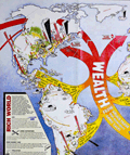 | Details | Fitzgerald, Paul | 1996 |
| Thematic world map Rich World Poor World |
|
Fitzgerald, Paul |
|
| 1996 |
| LOC:400 |
| $0.00 | Fitzgerald--Paul | Thematic-world-map-Rich-World-Poor-World | SOLD<br><br>An early, if not the earliest, large format pictorial map of the two-world model, used to attempt to explain the origins of economic inequities between the Global North (Rich World) and the Global South (Poor World). Map concept, text and artwork by Polyp ca. 1996. The map combines infographics with much textual explanation to explain the economic imbalances between the two conceptual worlds.
<br><br>
The term "Global South" refers to developing countries primarily located in Africa, Asia, and Latin America. These countries tend to be poorer, experience higher income inequality, and have harsh living conditions compared to the wealthier nations of the "Global North," mainly situated in North America, Europe, and Australia. The term "Global South" gained popularity after the collapse of the Soviet Union in 1991, replacing the previous term "Third World," (in a three-world model) which referred to developing nations during the time of colonialism.
<br><br>
Scarce. Six holdings in WorldCat. |