| | Thumbnail | | Creator | Date | Title / Author / Date / Location | Price | | | Description |
| 672 |  | Details | Bellin, Jacques Nicolas | 1760 |
| Antique French Chart of the Caribbean Island of Grenada |
|
Bellin, Jacques Nicolas |
|
| 1760 |
| LOC:51 |
| $675.00 | Bellin--Jacques-Nicolas | Antique-French-Chart-of-the-Caribbean-Island-of-Grenada | Striking, original antique French sea chart of the Island of Grenada in the Caribbean Sea. Possibly the last official French chart of the island as Britain wrested Grenada from France in 1762 during the Seven Years' War. By J.N. Bellin of the French Depot de la Marine.
<br></br>
Coverage includes several of the smaller islands and islets in the Grenadine's chain: Carriacou, Round Island (Isle Rond), l'Islet de la Tante, Islet de Levera, Islet de Mileu, Islet de Haut. The chart is large and colorful and will display nicely.
<br></br>
Noted features of this large navigational chart include Cape David, Cape de la Grenade, Pointe de la Grande Riviere, Pointe du Fort Jendy, Pointe des Salines, Piton (peak) de Levera, Sauteurs, the Bourg du Grand Marquis, Victoria, Gouyave, and the town of St. George ( Fort Royal ). Soundings and anchorages are shown for the vicinity of St. George's.
<br></br>
Inset profile view of the approach to the north end of the island showing le Grison, l'Islet Rond, Islet de la Tante, la Pointe Percee, and Cape David. With the circular logo of the French Depot de la Marine. Attributed to Bellin and dated to 1760 in a decorative title cartouche. Price: trente sols. No. 82. |
| 1024 | 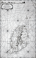 | Details | Bellin, Jacques Nicolas | 1760 |
| 1760 Nautical Chart of Grenada in the Caribbean Sea |
|
Bellin, Jacques Nicolas |
|
| 1760 |
| LOC:68 |
| $975.00 | Bellin--Jacques-Nicolas | 1760-Nautical-Chart-of-Grenada-in-the-Caribbean-Sea | Large antique French sea chart of the island of Grenada in the Carribbean Sea. Dated within the decorative title cartouche to 1760. Coverage includes several of the smaller islands and islets in the Grenadine's chain: Carriacou, Round Island (Isle Rond), l'Islet de la Tante, Islet de Levera, Islet de Mileu, Islet de Haut. By Jacques Bellin of the French Depot de la Marine.
<br></br>
This edition of Bellin's chart of Grenada lacks the circular logo of the Depot de la Marine at bottom right, the "No. 82" at top right, and the price. Contains an attractive inset elevation view of the approach to the north end of the island showing le Grison, l'Islet Rond, Islet de la Tante, la Pointe Percee, and Cape David.
<br></br>
Noted features of this large navigational chart include Cape David, Cape de la Grenade, Poine de la Grande Riviere, Pointe du Fort Jendy, Pointe des Salines, Piton (peak) de Levera, Sauteurs, the Bourg du Grand Marquis, Victoria, Gouyave, and the town of St. George ( Fort Royal ). Soundings and anchorages are shown for the vicinity of St. George's. |