| | Thumbnail | | Creator | Date | Title / Author / Date / Location | Price | | | Description |
| 105 |  | Details | Morisot, C.B. | 1643 |
| Piraticum Malabarum |
|
Morisot, C.B. |
|
| 1643 |
| LOC:0 |
| $0.00 | Morisot--C-B- | Piraticum-Malabarum | <BR> </BR>
SOLD
<BR> </BR>
Single sheet of chain laid paper with two engraved illustrations from the first comprehensive work on maritime history by Charles Barthelemy Morisot- "Orbis Maritimi siue Rerum". Page 719 contains a 5 1/2" x 6 1/2" view of natives from the East Indies piloting small craft. The obverse contains a 5 1/2" x 5" print of a small European-style galley with a single sail and 20 oars. That illustration is titled: "Tabula tertia Piraticum Malabarum describit." |
| 106 |  | Details | Morisot, C.B. | 1643 |
| Coracora a siue Carcola |
|
Morisot, C.B. |
|
| 1643 |
| LOC:0 |
| $0.00 | Morisot--C-B- | Coracora--a-siue-Carcola | <BR> </BR>
SOLD
<BR> </BR>
Single sheet of chain laid paper with two engraved illustrations from this early work by Morisot (1592-1661) on maritime history. Page 721 contains a profile view of three small vessels, one labeled "Ioncos" and another "Paros" (5 1/2" x 6 1/2") . Page 722 contains a outrigger canoe containing many warriors with spears labeled "Coracola a siue Carcola" (5 1/2" x 5"). Both illustrations accompanied with Latin text. |
| 2516 | 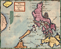 | Details | Morden, Robert | 1688 |
| The Philippine Isles |
|
Morden, Robert |
|
| 1688 |
| LOC:0 |
| $0.00 | Morden--Robert | The-Philippine-Isles | (SOLD) <br></br>Scarce map of the Philippines by Robert Morden (1650 – 1703). Morden was an English bookseller, publisher, and mapmaker. Includes the disputed Paracel Islands, an archipelago in the South China Sea. The Paracel Islands are controlled by the People's Republic of China, and also claimed by Taiwan and Vietnam. |
| 1185 | 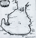 | Details | Aa, Pieter van der | 1719 |
| Bay of Manilla, Philippines Islands |
|
Aa, Pieter van der |
|
| 1719 |
| LOC:0 |
| $0.00 | Aa--Pieter-van-der | Bay-of-Manilla--Philippines-Islands | SOLD<br></br>
Rare Dutch map / chart of the Bay of Manilla, in the Philippine Islands. "De Stadt Manilha" is shown as a cluster of houses and churches. Details provided about depth soundings, and the relative location of rivers, habitations, and churches suggest that this small chart may have had its origin in a working nautical chart.
<br></br>
Pieter van der Aa (1659 - 1733) was a Dutch publisher working in Leiden during the early eighteenth century. He is best known for publishing maps and atlases, though he also printed pirated editions of foreign bestsellers and illustrated volumes. From "Nouvel atlas...contenant les principales cartes géographiques dressées suivant les nouvelles observations de Mr. de l'Académie royale des sciences" published in 1714 from Leiden by Van der Aa. Plate number 27 (in manuscript).
<br></br>
Printed on a large sheet measuring 19" W x 15" H. |
| 403 |  | Details | Bellin, Jacques Nicolas | 1752 |
| Philippines |
|
Bellin, Jacques Nicolas |
|
| 1752 |
| LOC:0 |
| $0.00 | Bellin--Jacques-Nicolas | Philippines | SOLD<br></br>Early map of the Philippines Islands by Bellin after Velarde . Dated 1752 in cartouche |
| 441 | 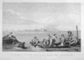 | Details | Duché de Vancy, Gaspard | 1797 |
| Vue de Cavite dans la Baie de Manille |
|
Duché de Vancy, Gaspard |
|
| 1797 |
| LOC:55 |
| $250.00 | Duché-de-Vancy--Gaspard | Vue-de-Cavite-dans-la-Baie-de-Manille | Engraved view of two boats and passengers with Cavite Philippines in the background as it was seen from Manilla Bay in January 1787.<BR> </BR>
Drawn by Gaspard Duchè de Vancy, a French artist of the 18th century. From the "Atlas du Voyage de La Perouse" published by Jean-Francois La Perouse. La Perouse led a scientific exploration to the Pacific from 1785, accompanied by Duchè de Vancy, and sent the drawing on which this engraving is based to France in 1788 with the intention of returning home by 1789. Departing Botany Bay, Australia in March, 1788 neither La Perouse, his ships the Boussole or Astrolabe, nor his men were ever seen again. Number 41.<BR> </BR>
Believe the engraving is an early 20th century re-strike from the original copper plate produced by the French Chalcographie du Louvre. La Chalcographie du Louvre is a repository of more that 13,000 original plates from the Louvre's archives, housed upstairs above the Louvre's Paris galleries . Upon request visitors can have a engraving produced on museum-quality paper from the original plate by a master printer. V.27 <BR> </BR> |
| 712 | 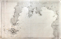 | Details | Direccion Hidrografia | 1875 |
| Isla de Mindanao |
|
Direccion Hidrografia |
|
| 1875 |
| LOC:0 |
| $0.00 | Direccion-Hidrografia | Isla-de-Mindanao | SOLD<br></br>Antique copper-plate engraved nautical chart of the southwest portion of the Philippine island of Mindanao and all of Sacol, Basilan, Olutanga, and Bongo islands. Key features include Zamboanga City, Bahia de Illana ( Illana Bay ) and Seno de Sibuguey ( Sibugay Bay ) and the Moro Gulf. The Zamboanga Peninsula is labeled "Reino de Sibuguey". Limited interior detail includes the Mindanao River, Panguil Bay, Mt. Tres Reyes, Mt. Kaladis, and Mount Silingan. On the tip of the peninsula is located a 'fuerza' or fort- the Real Fuerza de Nuestra Señora del Pilar de Zaragoza constructed by Spain beginning in 1635. With track lines shown for the course of steamship "Reina de Castilla" In 1862.
<br></br>
Published by Spain's Direccion Hidrografica from Madrid first in 1864, this issue is corrected to 1875. Plate 16 of a series of charts documenting the "Archipielago Filipino". Price when issued was 6 pesetas. Chart number 518. |