| | Thumbnail | | Creator | Date | Title / Author / Date / Location | Price | | | Description |
| 1012 | 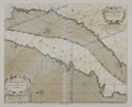 | Details | Mount and Page | 1715 |
| Antique chart of Africa from Agadir, Morocco to Nouadhibou, Mauritania |
|
Mount and Page |
|
| 1715 |
| LOC:0 |
| $285.00 | Mount-and-Page | Antique-chart-of-Africa-from-Agadir--Morocco-to-Nouadhibou--Mauritania | Two old charts on one sheet: West African coastline of Morocco, Western Sahara, and Mauritania from "Cape Geer" (north of Agadir near Tamri) south to "Cape Bajadore" (near Boujdour) and then south to the "Gulf of St. Ann" (Ras Nouadhibou). Nouadhibou has the unfortunate distiction of being the location of the world's largest ship graveyards, with over 300 rusting hulks abandoned by their owners .
<br></br>
Attribution on this old nautical chart has been partially erased but the lower cartouche one can see the faint remainder of the engraved names of John Seller and Charles Price. This edition of the antique chart is attributed to Mount and Page of London, 1715. |