| | Thumbnail | | Creator | Date | Title / Author / Date / Location | Price | | | Description |
| 4848 | 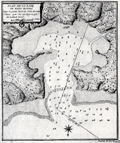 | Details | Laval, Antoine | 1728 |
| Scarce antique chart of Bahia Honda, Cuba |
|
Laval, Antoine |
|
| 1728 |
| LOC:13 |
| $250.00 | Laval--Antoine | Scarce-antique-chart-of-Bahia-Honda--Cuba | Antique copperplate engraved harbor chart shows Bahia Honda, Cuba as it existed in 1720. Bahia Honda, is located about 50 miles west of Havana in Artemisa province on the north-western coast of Cuba. Laval's chart predates Thomas Jeffery's "Plan of Bahia Honda" by more than 35 years and is the earliest known detailed harbor chart of Bahia Honda. It does not appear, however that Laval's map is based on any observations made by him as the ship he was on seems to have bypassed the Bay entirely on its way to Havana.
<br></br>
From the report of French astronomer and Jesuit Priest, Antoine Laval (1664-1728): "Voyage de la Louisiane", an account of the 1720 expedition to the Florida and Louisiana coasts led by French officer Valette de Laudun. Laval is recorded as mathematician or astronomer on that voyage. Laval was a professor of hydrography and mathematics based in the city of Toulon, France. Page 137.
<br></br>
Vallette de Laudun led the French expedition to Dauphin Island in the Gulf of Mexico between March and November, 1720. The 262-member crew embarked from Toulon, France, on the ship Toulouse , encountering Madeira, Martinique, Saint-Domingue, and Cuba before entering the Gulf of Mexico. Following a month at Dauphin Island, the expedition returned to France. |
| 1050 | 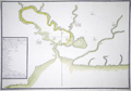 | Details | Real Escuela de Navegacion | 1735 |
| Early Manuscript plan of Cienfuegos Bay (Puerto de Jagua) |
|
Real Escuela de Navegacion |
|
| 1735 |
| LOC:0 |
| $3,100.00 | Real-Escuela-de-Navegacion | Early-Manuscript-plan-of-Cienfuegos-Bay-(Puerto-de-Jagua) | Pen and ink manuscript port plan of the Bahia de Cienfuegos, Cuba dating to the first half of the 18th century: "Puerto de Jagua". This is the earliest available manuscript plan of that important bay on the south coast of Cuba and is a near perfect copy of a map held in the Library of Congress (https://www.loc.gov/item/91680835/). The existence of multiple manuscript copies of the same chart is explained by the fact that the chart was produced by the Real Escuela de Navegación in Cadiz, whose role was to ensure the accuracy and consistency of maps produced for naval and commercial shipping and to house the growing record of maps and charts related to Spain's vast empire. Copyists at the school would have reproduced numerous identical copies by hand for distribution to military and commerical maritime users. During this time period few maps of Spain's New World possessions were reproduced by printing press, presumeably in order to limit their distribution. Spain's jealous secrecy over their colonial possessions is well documented.
<br></br>
The title and key are located within a frame at lower left; the chart shows coastline, coastal features, soundings, navigational hazards, an anchorage, a few buildings, roads, and streams.
<br></br>
Dating the map depends chiefly on its depiction of the location marked "B"- "lomas estrecho de la entrada" (Translated: Hilly narrow entrance). This site would later become the site of a fort or Castillo (Nuestra Señora de los Ángeles de Jagua) founded in 1745. On this chart, the fact that no mention is made of any structure suggests the map dates to before 1733 when construction on the fort began. On a later manuscript version for example that spot is defined as "es donde esta el Castillo, que es donde estaba la Bateria de ?[Fagina] (Translated: Where the castle is, which is where the Battery of ?? was.")
<br></br>
Note: "jagua" may be translated from Spanish as "Fruit of the custard-apple." |
| 1442 | 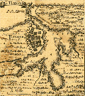 | Details | Popple, Henry | 1742 |
| Antique coastal chart of Havana And Santiago, Cuba |
|
Popple, Henry |
|
| 1742 |
| LOC:0 |
| $0.00 | Popple--Henry | Antique-coastal-chart-of-Havana-And-Santiago--Cuba | SOLD
<br></br>
Interesting and uncommon chart fragment with both Havana, Cuba and Santiago de Cuba, the first-largest and second-largest cities on that island.
<br></br>
This antique map was originally published by Covens and Mortier in 1742 in "Les Principales Forteresses Ports etc. de L'Amerique Septentrionale" a sheet containing harbor and island maps and plans of the Americas. This map is a fragment trimmed from the larger sheet.
<br></br>
That sheet of 18 maps and plans of islands and harbors was published by Covens and Mortier to replace Popple's original large map of 20 sheets with a more manageable six-sheet version. Popple's original map was titled: "A Map of the British Empire in America with the French, Spanish and the Dutch Settlements adjacent thereto". |
| 1455 | 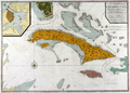 | Details | Mount and Page | 1746 |
| A New and Correct Chart of Cuba, Streights of Bahama Windward Passage Florida |
|
Mount and Page |
|
| 1746 |
| LOC:0 |
| $0.00 | Mount-and-Page | A-New-and-Correct-Chart-of-Cuba--Streights-of-Bahama-Windward-Passage-Florida | SOLD
<br></br>
You can smell the salt air! Mount & Page's impressive chart of the the island of Cuba, Florida Keys, and the Bahamas. This very fine antique nautical chart includes Grand Bahama island, Great Abaco, Eleuthera, Cat Island, Crooked Island and much more. With coverage between the southern part of Florida and Jamaica, centered on the Bahamas and Cuba. Includes the southern tip of Florida, Jamaica, east Cuba.
<br></br>
The map has been identifed as "An essential map for regional collectors." That may in part be related to the chart's massive mis-representation of the Gulf Stream which flows in a northerly direction through the Florida Strait. Arrows incorrectly show the flow from north to south, the opposite as is the case. In large engraved letters is stated: "The course of the current through the Gulf of Florida." In 1770 Benjamin Franklin published his map of the Gulf Stream with the correct course up the Eastern Seaboard and out into the Atlantic Ocean.
<br></br>
Large inset of Havana Harbor at upper left. Inset is titled: A plan of the Harbour and Town of Havana, taken on the spot by an officer in his Majesty's Navy.
<br></br>
The map includes a wonderful example of the Archipelago of Florida, as well as a detailed treatment of the Windward Passage and Bahamas. Within the Windward Passge a dotted line shows "The Course of the English Ships".
<br></br>
Key locations noted relative to Cuba include Havana, the capital and an important part of Spain's empire of domination, along with the Gulf of Zagua (See manucript map on this site). |
| 5377 | 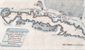 | Details | London Magazine | 1762 |
| Antique engraved Plan of the Straights of Bahama |
|
London Magazine |
|
| 1762 |
| LOC:13 |
| $325.00 | London-Magazine | Antique-engraved-Plan-of-the-Straights-of-Bahama | Original antique engraved map of the route taken by the British Fleet during their attack on the city of Havana, Cuba in 1762.
<br></br>
The map depicts the fleet's passage through the Old Bahamas Channel, a risky route just north of Cuba, through a channel only 10 miles wide at some points. The route taken by the British reduced the amount of warning time afforded to the Spanish Fleet.
<br></br>
Conducted during the Seven Years' War, the Siege of Havana was a successful British siege against Spanish-ruled Havana that lasted from March to August 1762.
<br></br>
"A Plan of the Straights of Bahama, through which the Expedition Fleet was Conducted in the Year 1762 against the Havana". Engraved for the London Magazine. Published from London by Baldwin in January 1763. |
| 3650 | 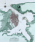 | Details | Depot de la Marine | 1762 |
| Antique French harbor chart of Havana, Cuba |
|
Depot de la Marine |
|
| 1762 |
| LOC:51 |
| $1,350.00 | Depot-de-la-Marine | Antique-French-harbor-chart-of-Havana--Cuba | Striking, original harbor chart and plan of the bay, town and forts of Havana, Cuba as they existed before 1762. Bellin identifies forty-five important locations in and around Havana and denotes their location on the plan alphabetically. Created by order of the Duc du Choiseul, French Minister of War.
<br></br>
With three inset plans "Le Fort du Maure" (Morro Castle, or more correctly- Castillo de los Tres Reyes del Morro), Fort de la Pointe (Castillo de San Salvador de la Punta), and Le Vieux Chateau (Castillo de la Real Fuerza) with 22 pieces of cannon. In 1762, after the Siege of Havana, the British captured all of Havana including the forts. All were returned to Spain a year later under terms of the Treaty of Paris.
<br></br>
This fine antique chart is from Nicolas Bellin, 1762, working for France's Depot des Cartes et Plans de la Marine.
<br></br>
With the circular anchor logo of the Depot de la Marine. Price when issued dix huit (18) Sols. No. 69. |
| 3655 | 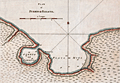 | Details | Jefferys, Thomas | 1762 |
| Antique plan of the Port de Baracoa, Cuba |
|
Jefferys, Thomas |
|
| 1762 |
| LOC:77 |
| $300.00 | Jefferys--Thomas | Antique-plan-of-the-Port-de-Baracoa--Cuba | A scarce antique copperplate-engraved chart of the Bay of Honey (Playa de Miel) and Port of Baracoa on Cuba's eastern tip. Baracoa is the oldest Spanish settlement in Cuba and was its first capital. The plan shows less than one dozen structures whereas in 2004, the municipality of Baracoa had a population of over eighty thousand.
<br></br>
This scarce English chart was published in 1762 by the prolific British engraver and publisher Thomas Jefferys (ca.1710-1771) in "A Description of the Spanish Islands and Settlements on the Coast of the West Indies, compiled from Authentic Memoirs, Revised by Gentlemen who have Resided Many Years in the Spanish Settlements".
<br></br>
Scale in sea leagues. At sea, a league is three nautical miles (3.45 miles). Plate 21. Page 84. |
| 1385 | 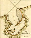 | Details | Jefferys, Thomas | 1762 |
| Antique British Plan of Puerto de Cavanas or Cabañas, Cuba |
|
Jefferys, Thomas |
|
| 1762 |
| LOC:5 |
| $325.00 | Jefferys--Thomas | Antique-British-Plan-of-Puerto-de-Cavanas-or-Cabañas--Cuba | Antique hand-colored copperplate engraved harbor chart shows Puerto de Cabañas (Cavanas), Cuba in the Artemisa province on the Northwestern coast of Cuba, about 50 km west of Havana, Cuba. In addition to depth soundings Jefferys identifies only three features in his plan of Cabañas Bay: An "aguada" or watering place, Ysla Larga, and Punta Longa.
<br></br>
The Bay of Cabañas was used as a haven for pirates to plunder Havana . In June, 1558 governor Diego de Mazariegos received news that pirate galleons had captured two Spanish caravels in a naval battle at the Bay of Cabañas. In 1586 the Spanish adopted measures for their defense against unfriendly nations and pirates. Those defensive measures stationed frigates and lookouts in the port of Cabañas in order to warn the town of Havana of impending attack.
<br></br>
This scarce nautical chart / plan was published in 1762 by the prolific British engraver and publisher Thomas Jefferys (ca.1710-1771) in "A Description of the Spanish Islands and Settlements on the Coast of the West Indies, compiled from Authentic Memoirs, Revised by Gentlemen who have Resided Many Years in the Spanish Settlements".
<br></br>
Scale in Miles. Plate 27. Page 90. |
| 264 |  | Details | Jefferys, Thomas | 1762 |
| Plan of the Colorado Rocks near the west end of Cuba. |
|
Jefferys, Thomas |
|
| 1762 |
| LOC:0 |
| $0.00 | Jefferys--Thomas | Plan-of-the-Colorado-Rocks-near-the-west-end-of-Cuba- | SOLD<br></br>
Antique copperplate engraved harbor chart of the barrier reef of Colorado's Archipelago on the westernmost point on the island of Cuba. This detailed chart covers the far west point of the Guanahacabibes Peninsula, Cape San Antonio and was published in 1762 by the prolific British engraver and publisher Thomas Jefferys (ca.1710-1771) in "A Description of the Spanish Islands and Settlements on the Coast of the West Indies, compiled from Authentic Memoirs, Revised by Gentlemen who have Resided Many Years in the Spanish Settlements".<br></br>
The amount and type of detail on this antique chart , lacking in many charts of this series, indicates as great familiarity with the area. Noted points of interest include an Isle of Pines (Pinos), Cape Corrientes, several watering places, a grove of date trees, and a beach with "white sands with cockle shells" near an "old ruined castle" where several soundings and the symbol of an anchor indicate a landing might be made. There is an interesting notation at top center of chart that identifies a rock offshore "Seen by the Cornwall Sept 8th 1748". <br></br>
Scale in sea leagues. Plate 25. Page 88. |
| 265 |  | Details | Jefferys, Thomas | 1762 |
| Plan of Puerto de Cavanas |
|
Jefferys, Thomas |
|
| 1762 |
| LOC:0 |
| $0.00 | Jefferys--Thomas | Plan-of-Puerto-de-Cavanas | SOLD ... but see an antique hand-colored example of this "Plan of Cavanas, Cuba" <a href="https://www.rarecharts.com/ShowDetail/Creator/Jefferys--Thomas/Title/Antique-British-Plan-of-Puerto-de-Cavanas-or-Caba%C3%B1as--Cuba/1385" target="_blank">we just added to our stock: </a>
<br></br>
Antique chart / plan of Puerto Cabanas (Cavanas), Cuba. |
| 266 | 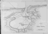 | Details | Jefferys, Thomas | 1762 |
| Plan of Bahia Honda |
|
Jefferys, Thomas |
|
| 1762 |
| LOC:0 |
| $0.00 | Jefferys--Thomas | Plan-of-Bahia-Honda | SOLD<br></br>
Antique nautical chart shows Bahia Honda, Cuba in Artemisa province on the Northwestern coast of that island nation, about 70 km west of Havana, Cuba. Copperplate engraved harbor chart published in 1762 by the prolific British engraver and publisher Thomas Jefferys (ca.1710-1771) in "A Description of the Spanish Islands and Settlements on the Coast of the West Indies, compiled from Authentic Memoirs, Revised by Gentlemen who have Resided Many Years in the Spanish Settlements".<br></br>
Two fishing spots are identified on the chart, one at the confluence of several creeks with the notation: "Here is plenty of fish to be caught". Scale in miles. Plate 26. Page 89. |
| 1081 | 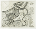 | Details | Coltellini, Marco | 1763 |
| Antique harbor chart and plan of Havana, Cuba |
|
Coltellini, Marco |
|
| 1763 |
| LOC:10 |
| $425.00 | Coltellini--Marco | Antique-harbor-chart-and-plan-of-Havana--Cuba | Antique chart from 1763 of the city and harbor of <b>Havana </b> on the island of Cuba. Two legends at far right in Italian are keyed to specific locations on the map including: the market; the Cathedral; churches; the powder magazine; defensive batteries and gun emplacements. Numerous soundings and shallow areas are identifed within the harbor. "Forte Moro" (<b>Morro Castle</b>) is clearly drawn opposite "Puntale" or San Salvador de la Punta Fortress, both guarding the entrance to the harbor.
<br></br>
Created by Marco Coltellini, drawn by Gieuseppe Pazzi, and published in volume 2 of the 1763 edition of the magazine "Il gazzettiere Americano" |
| 198 | 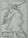 | Details | Bellin, Jacques Nicolas | 1764 |
| Le Port Marianne dans l'Isle de Cube. (Mariel, Cuba) |
|
Bellin, Jacques Nicolas |
|
| 1764 |
| LOC:5 |
| $185.00 | Bellin--Jacques-Nicolas | Le-Port-Marianne-dans-l-Isle-de-Cube--(Mariel--Cuba) | Antique black and white large-scale chart of Mariel harbor in the La Habana province of Cuba. This scarce engraved harbor chart is from Jacque Nicholas Bellin's "La Petit Atlas Maritime". Port of Mariel on the island of Cuba is labeled "Marianne". Mariel is the closest Cuban port to the U.S. Numerous soundings and sparse interior detail, in fact no habitation noted. Very good condition. Tome 1 No. 53. |
| 1374 | 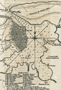 | Details | Smollett, Tobias G. | 1765 |
| Antique harbor plan or chart of Havana, Cuba |
|
Smollett, Tobias G. |
|
| 1765 |
| LOC:0 |
| $175.00 | Smollett--Tobias-G- | Antique-harbor-plan-or-chart-of-Havana--Cuba | Fine antique plan of the harbor and town of Havana ("Havanna"), Cuba in the Caribbean Sea from the middle of the 18th century. Rhumb lines, navigation hazards, sandbanks, and soundings suggest this small plan was based on a larger, probably military nautical chart of the location.
<br></br>
In writing about the port's defenses the author notes at bottom: "There are 2 castles on the shore one to the E. and the other to the W. each 5 miles from the town and mount 10 th. 12 guns."
<br></br>
20 key locations are identified, labeled alphabetically, and explained at bottom. For example:
<div class="indenttextblock">
<ul style="list-style-type: circle;">
<li>a. El Fuerte where the Governor resides, 22 guns.</li>
<li>b. The point gate and small fort</li>
<li>d. The barracks</li>
<li>g. The custom house and shipyard</li>
<li>k. Asiento factory</li>
<li>t. Nunneries</li>
</ul>
</div>
Other points of interest identified by the author include: Guanabacoa; Venta of Inn de Marmoleno; Estero de Cajunar; Morro Castle 52 guns; Battery called the 12 Apostles; Fort St. Maria de la Punta 30 guns; Nuestra Senora de la Regla [patron of the Bahía de la Habana].
<br></br>
The harbor plan of Havana comes from "History of England" by T. Smollett, published by Richard Baldwin, London. 1765. |
| 1117 | 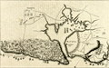 | Details | Anonymous | 1766 |
| A Plan of the Siege of the Havana 1762 |
|
Anonymous |
|
| 1766 |
| LOC:0 |
| $0.00 | Anonymous | A-Plan-of-the-Siege-of-the-Havana-1762 | SOLD<br></br>Antique map or plan of Havana, Cuba. This concise engraved harbor plan shows the disposition of British forces as they besieged and captured the city of Havana, Cuba in 1762, which at the time was a very important Spanish naval base in the Spanish West Indies. Shows two forts at the entrance channel: Castillo de los Tres Reyes del Morro (or Morro Castle) and Castillo de San Salvador de la Punta. A chain to block the channel is shown stretching between the two forts.
<br></br>
The Anglo-Spanish War of 1761-1763 saw Spain drawn into a global war, entering on the side of France during the Seven Years’ War, itself an outgrowth of the French and Indian War in North America. The siege of Havana, during the Anglo-Spanish War of 1761-1763, began in June 1762, led by George Keppel, 3rd Earl of Albemarle, and lasted until August 1762, with the surrender of Governor Juan de Prado.
<br></br>
As a result of the 1763 Treaty of Paris, Havana was returned to Spain but Spain was required to cede Florida and the Balearic Island of Minorca to Great Britain in return. Spain also received Louisiana as a payment for intervening in the war on the side of the French and as compensation for having lost Florida. Antonio Ulloa, who had taken part in a Spanish-French astronomical mission to South America, was appointed the first Governor of Louisiana, arriving in 1766 but ultimately was driven out of Louisiana in 1768 by French creoles and Acadians.
<br></br>
Published from London in Britannia Triumphant. |
| 3609 | 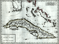 | Details | Mentelle and Chanlaire | 1798 |
| Attractive antique map of Florida, Cuba, and Bahamas |
|
Mentelle and Chanlaire |
|
| 1798 |
| LOC:0 |
| $0.00 | Mentelle-and-Chanlaire | Attractive-antique-map-of-Florida--Cuba--and-Bahamas | SOLD
<br></br>
Beautifully engraved and hand-colored map of southern Florida, Cuba, and the Bahama Islands (or Lucayes) from 1798. Points of interest in Florida include the Florida Keys (les Martyres), Port St. Lucie (Punta de Santa Lucia), Palm Beach (Cap della Floride), Cape Biscayne (Cap Biscaino). Beautifully engraved by Pierre Tardieu.
<br></br>
Published from Paris by French cartographers E. Mentelle and Pierre-Giles Chanlaire. Edme Mentelle (1730 - 1816) was a French geographer and historian in Paris who studied under the historian Jean-Baptiste Louis Crevier at the College of Beauvais. After accepting a position as professor of Geology and History at the Ecole Militaire he tutored students including the young Napoleon Bonaparte. Mentelle published a number of important geographical works including the 1778 Geographie Comparee, the 1779 Atlas Universel, and the 1801 Cours Complet de Cosmographie, de Chronologie, de Geographie et d'Histoire. Plate 3. |
| 3602 | 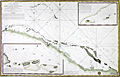 | Details | Depot de la Marine | 1801 |
| Antique French sea chart of northern Cuba and the Bahamas |
|
Depot de la Marine |
|
| 1801 |
| LOC:51 |
| $700.00 | Depot-de-la-Marine | Antique-French-sea-chart-of-northern-Cuba-and-the-Bahamas | Authentic, old French nautical chart, an attractive antique engraving with hand coloring ca. 1801.
Inset plans include:
<div class="indenttextblock">"Plan du Mouillage que forment les Cayesde Piedra, Mono, Monillo et autres ajacentes."</div>
<div class="indenttextblock">"Plan du Mouillage que forment les Cayes Verde et Confites."
<br></br>
French antique navigation chart of the "Vieux Canal" or old canal of the Bahamas. Other features (in French) include Canal de Santarem and Banc de Los Rocques. Inset chart of the anchorage near Cayo Blanco ("les Cayes de Piedras, Monillo, et autres ajacentes") and of the anchorage at Cayo Verde and Cayo Confites. Circular logo of the Depot de la Marine.
<br></br>
"Carte Reduite d'Une Partie du Vieux Canal de Bahama st des Bancs Adjacents". Dated "l'An X" (10th year of the Revolutionary calendar). Published in Paris. |
| 239 | 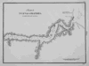 | Details | Direccion Hidrografia | 1809 |
| Puerto de Nuevas Grandes |
|
Direccion Hidrografia |
|
| 1809 |
| LOC:5 |
| $400.00 | Direccion-Hidrografia | Puerto-de-Nuevas-Grandes | Beautiful, black and white engraved copperplate chart of Puerto de Nuevas Grandes, in the province of Camaguey, on the northern coast of Cuba. Published in 1809, this chart was one of 34 charts of Cuban ports published by the Spanish Admiralty, the Direccion Hidrografia, in the sea atlas "Portolano de la America Setentrional Construido en la Direccion Detrabajos Hidrograficos". <BR> </BR>
A fine example with careful, delicate engraving and a wide platemark on high-quality paper. Distance scale is in cables. Engraved by J.C. Part 3. Plate #27.<BR> </BR>
Reference: Materiales para una Cartografia Mexicana. Manuel Orozco y Berra. 1871. p. 216.
<br></br>
<a href="/DireccionHidrografiaBackground.aspx" > See all items by Spain's Direccion de Hidrografia.</a> |
| 240 | 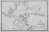 | Details | Direccion Hidrografia | 1809 |
| Puerto del Padre |
|
Direccion Hidrografia |
|
| 1809 |
| LOC:5 |
| $450.00 | Direccion-Hidrografia | Puerto-del-Padre | Beautiful, black and white engraved copperplate chart of Puerto del Padre, in the province of Las Tunas, on the northern coast of Cuba. Published in 1809, this chart was one of 34 charts of Cuban ports published by the Spanish Admiralty, the Direccion Hidrografia, in the sea atlas "Portolano de la America Setentrional Construido en la Direccion Detrabajos Hidrograficos". Puerto del Padre is one of several ports in Cuba that lay claim as the first spot in Cuba where Christopher Columbus landed on his well known 1492 exploration of the new world.<BR> </BR>
A fine example with careful, delicate engraving and a wide platemark on high-quality paper. Distance scale is in cables. Engraved by J.C. Part 3. Plate #25.<BR> </BR>
Reference: Materiales para una Cartografia Mexicana. Manuel Orozco y Berra. 1871. p. 216. |
| 241 | 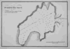 | Details | Direccion Hidrografia | 1809 |
| Puerto de Taco |
|
Direccion Hidrografia |
|
| 1809 |
| LOC:5 |
| $400.00 | Direccion-Hidrografia | Puerto-de-Taco | Beautiful, black and white engraved copperplate harbor chart of the Bahia de Taco, in the province of Guantanamo, on the far northeastern coast of Cuba. The Bahia de Taco lies very near a UNESCO world heritage site, the Parque National Alejandro de Humboldt. The 275 square mile park is one of the most biologically diverse sites in the Caribbean basin and is home to a 3832 foot mountain peak named El Todo.<BR> </BR>
Published in 1809, this chart of Puerto de Taco was one of 34 charts of Cuban ports published by the Spanish Admiralty, the Direccion Hidrografia, in the sea atlas "Portolano de la America Setentrional Construido en la Direccion Detrabajos Hidrograficos". A fine example with careful, delicate engraving and a wide platemark on high-quality paper. Distance scale is in cables. Part 3. Plate #9.<BR> </BR>
Reference: Materiales para una Cartografia Mexicana. Manuel Orozco y Berra. 1871. p. 216. |
| 244 | 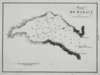 | Details | Direccion Hidrografia | 1809 |
| Puerto de Maravi (Bahia de Maravi) |
|
Direccion Hidrografia |
|
| 1809 |
| LOC:5 |
| $400.00 | Direccion-Hidrografia | Puerto-de-Maravi-(Bahia-de-Maravi) | Beautiful, black and white engraved copperplate chart of the Bay of Maravi, Cuba a cove on the northeast coast of Cuba in Guantanamo province. <BR> </BR>
Published in 1809, this rare chart of Maravi Bay was one of 34 charts of Cuban ports published by the Spanish Admiralty, the Direccion Hidrografia, in the sea atlas "Portolano de la America Setentrional Construido en la Direccion Detrabajos Hidrograficos". A fine example with careful, delicate engraving and a wide platemark on high-quality paper. Distance scale is in cables. Engraved by J.C. Part 3. Plate #6.<BR> </BR>
Reference: Materiales para una Cartografia Mexicana. Manuel Orozco y Berra. 1871. p. 216. |
| 245 | 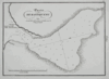 | Details | Direccion Hidrografia | 1809 |
| Puerto de Baitiqueri |
|
Direccion Hidrografia |
|
| 1809 |
| LOC:5 |
| $400.00 | Direccion-Hidrografia | Puerto-de-Baitiqueri | Beautiful, black and white engraved copperplate chart of the Bay of Baitiqueri, Cuba on the northeast coast of Cuba in Guantanamo province. <BR> </BR>
Published in 1809, this rare chart was one of 34 charts of Cuban ports published by the Spanish Admiralty, the Direccion Hidrografia, in the sea atlas "Portolano de la America Setentrional Construido en la Direccion Detrabajos Hidrograficos". A fine example with careful, delicate engraving and a wide platemark on high-quality paper. Distance scale is in cables. Part 3. Plate #3.<BR> </BR>
Reference: Materiales para una Cartografia Mexicana. Manuel Orozco y Berra. 1871. p. 216. |
| 246 | 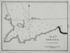 | Details | Direccion Hidrografia | 1809 |
| Puerto de Jaragua (Bahia de Jaragua) |
|
Direccion Hidrografia |
|
| 1809 |
| LOC:5 |
| $400.00 | Direccion-Hidrografia | Puerto-de-Jaragua-(Bahia-de-Jaragua) | Beautiful, black and white engraved copperplate chart of the Bay of Jaragua, Cuba on the northeast coast of Cuba in Guantanamo province. <BR> </BR>
Published in 1809, this rare chart of Jaragua bay was one of 34 charts of Cuban ports published by the Spanish Admiralty, the Direccion Hidrografia, in the sea atlas "Portolano de la America Setentrional Construido en la Direccion Detrabajos Hidrograficos". A fine example with careful, delicate engraving and a wide platemark on high-quality paper. Distance scale is in cables. Engraved by J.C. Part 3. Plate #10.<BR> </BR>
Reference: Materiales para una Cartografia Mexicana. Manuel Orozco y Berra. 1871. p. 216. |
| 247 | 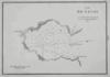 | Details | Direccion Hidrografia | 1809 |
| Puerto de Navas (Bahia Navas) |
|
Direccion Hidrografia |
|
| 1809 |
| LOC:5 |
| $400.00 | Direccion-Hidrografia | Puerto-de-Navas-(Bahia-Navas) | Beautiful, black and white engraved copperplate chart of the Bay of Navas, Cuba on the northeast coast of Cuba in Guantanamo province. Navas is about 2.3 km northwest of Cayoguaneque.<BR> </BR>
Published in 1809, this rare chart of Navas Bay was one of 34 charts of Cuban ports published by the Spanish Admiralty, the Direccion Hidrografia, in the sea atlas "Portolano de la America Setentrional Construido en la Direccion Detrabajos Hidrograficos". A fine example with careful, delicate engraving and a wide platemark on high-quality paper. Distance scale is in cables. Part 3. Plate #7.<BR> </BR>
Reference: Materiales para una Cartografia Mexicana. Manuel Orozco y Berra. 1871. p. 216. |
| 248 | 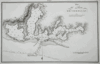 | Details | Direccion Hidrografia | 1809 |
| Plano del Puerto de Cebollas (Bahia de Cebollas) |
|
Direccion Hidrografia |
|
| 1809 |
| LOC:5 |
| $600.00 | Direccion-Hidrografia | Plano-del-Puerto-de-Cebollas-(Bahia-de-Cebollas) | Beautiful, black and white engraved copperplate chart of the Bay of Cebollas, Cuba on the northeast coast of Cuba in Holguin province. Strong graphic composition; this engraving and the plate of Puerto de Vita would make a fine grouping. This chart is about 20% larger than other port plans in this series.<BR> </BR>
Published in 1809, this rare chart of Cebollas Bay was one of 34 charts of Cuban ports published by the Spanish Admiralty, the Direccion Hidrografia, in the sea atlas "Portolano de la America Setentrional Construido en la Direccion Detrabajos Hidrograficos". A fine example with careful, delicate engraving and a wide platemark on high-quality paper. Distance scale is in cables. Part 3. Plate 14.<BR> </BR>
Reference: Materiales para una Cartografia Mexicana. Manuel Orozco y Berra. 1871. p. 216. |
| 249 | 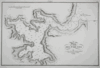 | Details | Direccion Hidrografia | 1809 |
| Plano del Puerto de Vita |
|
Direccion Hidrografia |
|
| 1809 |
| LOC:5 |
| $650.00 | Direccion-Hidrografia | Plano-del-Puerto-de-Vita | Beautiful, black and white copperplate engraved chart of the Port of Vita, Cuba on the northeast coast of Cuba in Holguin province. Commerce at the Puerto de Vita, Cuba includes the Marina Internacional Puerto de Vita with moorings for 38 boats. The port is reported to offer sufficient protection from hurricanes and also is one of the few Cuban ports where small cruising boats can clear customs. <BR> </BR>
Strong graphic composition; this engraving and the plate of Puerto de Cebollas would make a fine grouping. This chart is about 20% larger than other port plans in this series. Published in 1809, this rare chart of Puerto de Vita was one of 34 charts of Cuban ports published by the Spanish Admiralty, the Direccion Hidrografia, in the sea atlas "Portolano de la America Setentrional Construido en la Direccion Detrabajos Hidrograficos". A fine example with careful, delicate engraving and a wide platemark on high-quality paper. Distance scale is in cables. Part 3. Plate 21.<BR> </BR>
Reference: Materiales para una Cartografia Mexicana. Manuel Orozco y Berra. 1871. p. 216. |
| 238 | 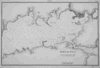 | Details | Direccion Hidrografia | 1809 |
| Bahia de Jagua (Cienfuegos) |
|
Direccion Hidrografia |
|
| 1809 |
| LOC:5 |
| $0.00 | Direccion-Hidrografia | Bahia-de-Jagua-(Cienfuegos) | Enquire for price.
<BR> </BR>
Beautiful antique, black and white engraved copperplate port plan of Jagua Bay, (now Cienfuegos) on the southern coast of Cuba. Published in 1809, this chart of Cienfuegos Bay was one of 34 charts of Cuban ports published by the Spanish Admiralty, the Direccion Hidrografia, in the sea atlas "Portolano de la America Setentrional Construido en la Direccion Detrabajos Hidrograficos". <BR> </BR>
Highlights include a fortress, 'Castillo de Nuestra Señora de los Angeles', built in 1745 at the mouth of the bay for protection from pirates. Unlike many other port plans, very few structures are noted and the position of the Castillo is hardly noticeable as it represented with only a very small double circle and even smaller lettering. A fine example with careful, delicate engraving and a wide platemark on high-quality paper. Distance scale is in cables. Engraved by T.G. Part 3. Plate #33.<BR> </BR>
Reference: Materiales para una Cartografia Mexicana. Manuel Orozco y Berra. 1871. p. 216.
<br></br>
<a href="/DireccionHidrografiaBackground.aspx" > See all items by Spain's Direccion de Hidrografia.</a> |
| 242 | 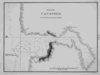 | Details | Direccion Hidrografia | 1809 |
| Puerto de Cananova |
|
Direccion Hidrografia |
|
| 1809 |
| LOC:5 |
| $400.00 | Direccion-Hidrografia | Puerto-de-Cananova | Beautiful, black and white engraved copperplate harbor chart of the shallow Bahia de Cananova, in the province of Holguin, on the northeastern coast of Cuba. It is generally accepted that Columbus landed in Holguin province on October 27, 1492 during his initial exploratory voyage, just two weeks after first landing in the New World at the Bahamas. <BR> </BR>
Published in 1809, this rare chart was one of 34 charts of Cuban ports published by the Spanish Admiralty, the Direccion Hidrografia, in the sea atlas "Portolano de la America Setentrional Construido en la Direccion Detrabajos Hidrograficos". A fine example with careful, delicate engraving and a wide platemark on high-quality paper. Distance scale is in cables. Engraved by J.C. Part 3. Plate #13.<BR> </BR>
Reference: Materiales para una Cartografia Mexicana. Manuel Orozco y Berra. 1871. p. 216. |
| 243 |  | Details | Direccion Hidrografia | 1809 |
| Puerto de Cayaguaneque (Cayoguaneque) |
|
Direccion Hidrografia |
|
| 1809 |
| LOC:5 |
| $400.00 | Direccion-Hidrografia | Puerto-de-Cayaguaneque-(Cayoguaneque) | Beautiful, black and white engraved copperplate harbor chart of Puerto de Cayaguaneque (or Cayoguaneque), Cuba a cove on the northeast coast of Cuba in Guantanamo province . <BR> </BR>
Published in 1809, this rare chart was one of 34 charts of Cuban ports published by the Spanish Admiralty, the Direccion Hidrografia, in the sea atlas "Portolano de la America Setentrional Construido en la Direccion Detrabajos Hidrograficos". A fine example with careful, delicate engraving and a wide platemark on high-quality paper. Distance scale is in cables. Engraved by J.C. Part 3. Plate #8.<BR> </BR>
Reference: Materiales para una Cartografia Mexicana. Manuel Orozco y Berra. 1871. p. 216. |
| 237 |  | Details | Direccion Hidrografia | 1809 |
| Puerto de Gibara |
|
Direccion Hidrografia |
|
| 1809 |
| LOC:5 |
| $400.00 | Direccion-Hidrografia | Puerto-de-Gibara | Beautiful, black and white engraved copperplate port plan of the port of Gibara on northeast coast of Cuba. Published in 1809, before the town of Gibara was founded, this antique plan / chart is one of 34 charts of Cuban ports published by the Spanish Admiralty, the Direccion Hidrografia, in the sea atlas "Portolano de la America Setentrional Construido en la Direccion Detrabajos Hidrograficos". <BR> </BR>
A fine example with careful, delicate engraving and a wide platemark on high-quality paper. Distance scale is in cables. Part 3. Plate #24.<BR> </BR>
Reference: Materiales para una Cartografia Mexicana. Manuel Orozco y Berra. 1871. p. 216.
<br></br>
<a href="/DireccionHidrografiaBackground.aspx" > See all items by Spain's Direccion de Hidrografia.</a> |
| 236 | 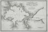 | Details | Direccion Hidrografia | 1809 |
| Plano del Puerto de Banes |
|
Direccion Hidrografia |
|
| 1809 |
| LOC:5 |
| $400.00 | Direccion-Hidrografia | Plano-del-Puerto-de-Banes | Beautiful, black and white engraved copperplate port plan of Banes, Cuba, birthplace of former dictator Fulgencio Batista, located on the northeast coast of that island nation. Published in 1809, this antique chart of Banes harbor is one of 34 charts of ports in Cuba published by the Spanish Admiralty, the Direccion Hidrografia, in the sea atlas "Portolano de la America Setentrional Construido en la Direccion Detrabajos Hidrograficos". <BR> </BR>
Highlights include elaborate calligraphic title and spare, careful engraving with a wide platemark on high-quality paper. Distance scale is in cables. Engraved by J.C. Part 3. Plate #18.<BR> </BR>
Reference: Materiales para una Cartografia Mexicana. Manuel Orozco y Berra. 1871. p. 216.
<br></br>
<a href="/DireccionHidrografiaBackground.aspx" > See all items by Spain's Direccion de Hidrografia.</a> |
| 3656 | 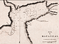 | Details | Direccion Hidrografia | 1809 |
| Puerto de Matanzas, Cuba |
|
Direccion Hidrografia |
|
| 1809 |
| LOC:77 |
| $400.00 | Direccion-Hidrografia | Puerto-de-Matanzas--Cuba | Scarce antique copperplate-engraved harbor chart of the Bay of Matanzas, Cuba on the northern coast of the island. Shows the then tiny Pueblo de San Carlos de Matanzas. Key features include Rio de Matanzas, Rio de Yumuris, Rio Canima, and the Castillo de San Severino, built in 1735. Bombed by the British in 1762, it was rebuilt in the 1770s. The Castillo became an offloading point for slaves and today is the site of the slavery-themed Museo de la Ruta de los Esclavos.
<BR> </BR>
Published in 1809, this rare chart was one of 34 charts of Cuban ports published by the Spanish Admiralty, the Direccion Hidrografia, in the sea atlas "Portolano de la America Setentrional Construido en la Direccion Detrabajos Hidrograficos". A fine example with careful, delicate engraving and a wide platemark on high-quality paper. Distance scale is in cables. Engraved by J.C. Part 3, Cuba. Plate #29.
<BR> </BR>
Reference: Materiales para una Cartografia Mexicana. Manuel Orozco y Berra. 1871. p. 216. |
| 942 | 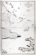 | Details | Direccion Hidrografia | 1867 |
| Antique Spanish Chart of Eastern Cuba and the Bahama Bank |
|
Direccion Hidrografia |
|
| 1867 |
| LOC:0 |
| $900.00 | Direccion-Hidrografia | Antique-Spanish-Chart-of-Eastern-Cuba-and-the-Bahama-Bank | Striking antique Spanish sea-chart of the southeastern Bahamas. This attractive 150 year old nautical artifact would make a fine gift for yachtsmen, fishermen, and sailors with an interest in the waters near the Windward Passage, the 50 mile-wide strait between Cuba and Hispaniola connecting the Atlantic Ocean and the Caribbean Sea.
<br></br>
This venerable nautical survivor includes western Haiti, eastern Cuba, east Jamaica, and the Inagua Islands. Covers the southern portion of the Great Bahama Bank, Grand Inagua Island, Little Inagua Island, Crooked Island, Acklins Island, Rum Cay, Conception Island, Mayaguana, Great Exuma; Providenciales, Turks and Caicos; Cat Island, San Salvador Islands ("Isla Watlings") , and the southern part of Eleuthera ("Isla Hetera"). Key cities noted include Kingston, Jamaica; Port-au-Prince ("Puerto Principe"), Haiti; Baracoa and Santiago de Cuba, Cuba.
<br></br>
Certainly a fine example of a mid-nineteenth century working navigational chart with numerous soundings, particularly in the area of the Great Bahama Bank. Nine lighthouses are identified with red and yellow highlights. Originally issued in 1856, this edition was printed with additions and corrections in 1867 by Spain's official maritime agency, the Direccion Hidrografia. |
| 5007 | 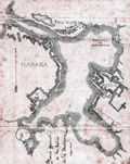 | Details | Pujals, Jose | 1891 |
| Antique manuscript map plan of the Bay of Havana, Cuba with Regla |
|
Pujals, Jose |
|
| 1891 |
| LOC:200 |
| $700.00 | Pujals--Jose | Antique-manuscript-map-plan-of-the-Bay-of-Havana--Cuba-with-Regla | MS plan and hydrographic chart of the bay of Havana, Cuba. Very early surveyor's master document on tracing cloth of Havana, Cuba with blue color from the verso, as was the practice of the era for creating shading on blueprints. This manuscript map was intended for use in generating multiple cyanotype (blueprint) copies.
<br></br>
Names several important locations including Regla, Cabana, Ensenada de Mari Melena, and Casa Blanca. The plan includes isobaths showing depth of water in Havana Bay.
<br></br>
MS notation in Spanish reads: "Corresponde a la Real Orden de consesion des dichas obras fecha de 17 de ?? Habana de 13 Febrero de 1891 J. Pujals"
<br></br>
Creator is presumed to be Jose Pujals, an engineer with the Port of Havana Cuba. In 1899 Jose Pujals was the directing engineer in charge of works at the Port of Havana. On February 1, Captain A.H. Weber of the Second United States Volunteer Engineers was appointed as directing engineer and Pujals was moved to a position as Weber's assistant.
<br></br>
Scale 1:2500. |
| 7917 | 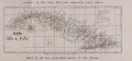 | Details | Ricoy, M. | 1896 |
| Mapa de la Isla de Cuba |
|
Ricoy, M. |
|
| 1896 |
| LOC: |
| $200.00 | Ricoy--M- | Mapa-de-la-Isla-de-Cuba | Promotional map of Cuba issued in 1896 to advertise “Cuba” brand Havana cigarettes, with the slogan “Cuba is the best Havana cigarette ever made.” The map shows the island’s provinces, towns, roads, railways, and lighthouses, with a legend identifying provincial capitals, judicial districts, and rail lines under construction. Printed in Havana by M. Ricoy during the final years of Spanish colonial rule, the map reflects the geography of Cuba on the eve of the Spanish–American War. |
| 7992 | 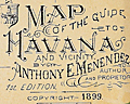 | Details | Menendez, Anthony E. | 1899 |
| Map of Havana and Vicinity |
|
Menendez, Anthony E. |
|
| 1899 |
| LOC:86 |
| $250.00 | Menendez--Anthony-E- | Map-of-Havana-and-Vicinity | First edition map of Havana, Cuba and the surrounding area. Copyright 1899. Small inset coastal recognition view of the lighthouse and Morro Castle at the entrance to Havana Harbor opposite la Punta.
<br><br>
Scarce 1899 tourist map of Havana, Cuba, compiled and published by Anthony E. Menendez as the “Map of the City of Havana and Vicinity,” issued as the 1st Edition. Printed with a full street grid and surrounded by extensive indexes, the map identifies streets, parks, plazas, churches, markets, government offices, public buildings, hospitals, theaters, banks, and railway stations using an alphanumeric reference system. Major military and harbor defenses—including Morro Castle, La Cabaña, and La Punta—appear as engraved vignettes, along with illustrations of key civic structures across the city.
<br><br>
The plan captures the arrangement of Havana at the turn of the twentieth century during the U.S. military administration following the Spanish–American War. The city’s waterfront, harbor entrance, wharves, and ferry routes are clearly plotted, and the western suburbs and parklands are shown with their developing street patterns. A large inset at lower right depicts the Grand Hotel Pasaje, while advertising across the top margin promotes the “Cuba” brand cigarette, indicating commercial distribution of the map.
<br><br>
A detailed and visually engaging guide-map from a pivotal moment in Havana’s history, notable for its combination of practical indexing, architectural vignettes, and period promotional material. |
| 5136 |  | Details | Seaboard Air Line Railway | 1904 |
| Antique Panoramic View of Havana Cuba |
|
Seaboard Air Line Railway |
|
| 1904 |
| LOC:51 |
| $550.00 | Seaboard-Air-Line-Railway | Antique-Panoramic-View-of-Havana-Cuba | Antique folding half-tone panoramic view of Havana, Cuba (1904) titled "Havana Harbor and City." A very fine view from a brochure by the Seaboard Air Line Railway "Cuba" promoting the route of the Peninsular and Occidental Steamship Company's steamship from Port Tampa to Key West, Florida to Havana.
<br></br>
A drawing, resembling a photograph, showing a panoramic view taken from the perspective of La Cabaña, (Fortaleza de San Carlos de la Cabaña). At upper right the view shows Morro Castle and lighthouse at the entrance to Havana Bay. Across the bay, the city of Havana shines, while sailing vessels and steam powered ships ply the waters of the bay. A reviewer of the period described the work as:
<div class="indenttextblocksingle">
<ul style="list-style-type: circle;">
… a panoramic view of Havana Harbor and City superbly reproduced in half-tone, the sky and water effects being especially meritorious, showing skillful overlay and press-work." [1].
</ul>
</div>
Brochure printed by Edgell Press. Cover to brochure included.
<BR></BR>
[1] Ryan, Charles B. Transportation. January 1904. No. 1. p. 29. |
| 5064 |  | Details | Florida East Coast Hotels | 1908 |
| Scarce Hotel Sevilla, Havana Cuba Point of Sale Advertisement |
|
Florida East Coast Hotels |
|
| 1908 |
| LOC:400 |
| $325.00 | Florida-East-Coast-Hotels | Scarce-Hotel-Sevilla--Havana-Cuba-Point-of-Sale-Advertisement | Rare point-of-sale advertising placard for the opening of Hotel Sevilla in Havana, Cuba. 1908. With information and six pasted photographs for Hotel Sevilla. Two sides on hard stock with red edging. Verso with two large photographs for Hotel Champlain.
<br></br>
The Hotel Sevilla was scheduled to open on December 1st, 1908 under the management of A.E. Dick:
<div class="indenttextblocksingle">
"A new modern hotel with every convenience situated near the park and Prado, Expensively furnished throughout, delightfully comfortable, lofty ceilings, tiled floors, open courts, balconies, every room with a bath and other modern conveniences, electric lights, bells and telephones in every room."
</div> |