| | Thumbnail | | Creator | Date | Title / Author / Date / Location | Price | | | Description |
| 1337 | 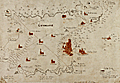 | Details | Anonymous | 1660 |
| Very old manuscript map of Guernsey Island |
|
Anonymous |
|
| 1660 |
| LOC:0 |
| $0.00 | Anonymous | Very-old-manuscript-map-of-Guernsey-Island | SOLD <br></br>
<br></br>
Very old manuscript map of the island of Guernsey ( "Gernsaye" ), one of the Channel Islands in the English Channel near the French coast. Estimated ca. 1660. Locates all the churches on the island. Saint Peter Port is referenced only as "the towne". The map shows the "Chastion Cornet" or Castle Cornet offshore where today it is but a short walk from town center.
<br></br>
Manuscript signature at bottom "Reginaldo Wolfio Autore". The map does not appear to be drawn with much skill, raising the possibility that this is a quick copy of another work, perhaps a map of Guernsey by Blaeu. Contains many of the guide lines used to construct the map, perhaps based on bearings from key points.
<br></br>
A few wormholes passing through the original and the backing paper suggest substantial age to the work. |
| 556 | 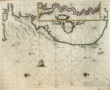 | Details | Goos, Pieter | 1667 |
| Pascaarte van Engelant |
|
Goos, Pieter |
|
| 1667 |
| LOC:57 |
| $1,300.00 | Goos--Pieter | Pascaarte-van-Engelant | Lovely copperplate engraved sea chart of the East Coast of England with the Thames estuary by Dutch cartographer Pieter Goos. Inset of the Thames River including London. The date of publication was just one year after the great fire that destroyed London in 1666. Place names and feature descriptions are in Dutch.<br><br/>
From Pieter Goos' De Zee-Atlas, Ofte Water-Weereld, Waer in vertoont werden alle de Zee-Kusten Van het bekende des Aerd-Bodems. 1667. |
| 4842 | 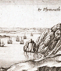 | Details | Hollar, Wenceslaus | 1676 |
| Rare view of Plymouth, England with the Catwater |
|
Hollar, Wenceslaus |
|
| 1676 |
| LOC:13 |
| $250.00 | Hollar--Wenceslaus | Rare-view-of-Plymouth--England-with-the-Catwater | Rare, small view of Plymouth, England with the Catwater from 1676 by Czech etcher Wenceslaus Hollar (1607-1677). From a series by Hollar titled "Divers Views after the Life." No record of any sale in AMPR; none online for sale. Signed within as "W. Hollar fecit 1676".
<br></br>
Hollar published his first book of etchings in 1635 in Cologne when Hollar was twenty-eight. Hollar was in London during the Great Fire of 1666, and remains most famous for his scenes of the city before and after the fire. |
| 1313 | 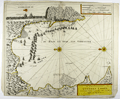 | Details | Loots, Johannes | 1705 |
| Very rare battle plan of the 1704 Capture of Gibraltar. |
|
Loots, Johannes |
|
| 1705 |
| LOC:200 |
| $0.00 | Loots--Johannes | Very-rare-battle-plan-of-the-1704-Capture-of-Gibraltar- | SOLD<br></br><br>Very rare first edition broadsheet chart / view of the Capture of Gibraltar in 1704 by Dutch cartographer Johannes Loots (w. 1693-1726). On 4th August 1704, during the war of the Spanish Succession, an Anglo-Dutch fleet under the command of Admiral George Rooke seized Gibraltar from the Spanish. From dawn on that day and for the next five hours, some 15,000 canons were fired from the fleet into the city. The English majority captors, landed the same morning and not surprisingly encountered little opposition.
<br></br>
Antique Map Price Record has no record of a sale of this chart by Johannes Loots. Charts by Loots are very scarce; only 11 charts by Loots are recorded in the Antique Map Price Record covering 210,000 map and chart sales in the last 35 years. Only two copies of this chart are listed in OCLC World Cat, both at Harvard.
<br></br>
From Koeman's biography of Johanne's Loots (1665[6] - 1726) we know Loots was born in Amsterdam and is not as is sometimes believed one of the two sons of Anthonie (Theunisz) Jacobsz who named themselves Lootsman to confuse cartographic researchers in future centuries. Loots served an apprenticeship under Hendrick Doncker as a maker of mathematical and nautical instruments including cross-staffs. Loots was accepted into the Guild of Booksellers in 1693 and settled into a shop in the Nieuebrugsteeg 'In de Jong Lootsman'.
<br></br>
Title reads: " Tot Amsterdam by Ionnes Loots Boek Zeekard Verkooper en Graadboog Maker inde Nieuwe brugsteed Ionge Lootsman." |
| 250 | 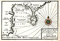 | Details | Michelot and Bremond | 1727 |
| Plan de la Baye de Gibraltar |
|
Michelot and Bremond |
|
| 1727 |
| LOC:4 |
| $300.00 | Michelot-and-Bremond | Plan-de-la-Baye-de-Gibraltar | An attractive and scarce antique copperplate large scale chart of the bay and peninsula of Gibraltar, a British Overseas Territory. Contains detail on the fortifications and numerous guard towers in the area. Numerous soundings, anchorages, and navigation hazards are noted. Hand colored compass rose. Algeciras is labeled "Vieux Gibraltar". Other noted locations include the old and new quay (mole), Cap Carnero, Plaine de St. Roch and the Ville et Mt. Gibraltar (Rock of Gibraltar).
<br></br>
This plan was produced in 1727 by French hydrographers and galley pilot <a style="color:#9BAFCB" rel="nofollow" href= "/MichelotBremondBackground.aspx">Henry Michelot</a> and Laurens Bremond . This old chart of Gibraltar is one of a handful of Michelot and Bremond charts that were copied by Thomas Kitchin and others for more than 30 years and it should be a part of any serious collection of maps from that region.
<BR> </BR>
Engraved by one of the finest engravers of the time, Peter Starckman. Carries the sellers information: " Ce Vend chez Laurens Bremond sur le Port a Marseilles a coin de Reboul." Published with the royal privilege. |
| 50 | 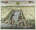 | Details | Kip, Johannes | 1728 |
| Howland Great Dock near Deptford |
|
Kip, Johannes |
|
| 1728 |
| LOC:141 |
| $800.00 | Kip--Johannes | Howland-Great-Dock-near-Deptford | A scarce early 18th century engraved view of the Howland Great Wet Dock (later Greenland Dock) at Rotherhithe, depicting one of the earliest purpose built wet docks in England and a key stage in London's transition from medieval tidal wharfage to enclosed, engineered dock systems. This view has margins > 3 inches. Shown from an elevated birds eye perspective, the composition centers on the rectangular dock basin with its lock entrance to the Thames, where vessels remain afloat at constant water level, a significant technical advance for fitting out, repair, and long term mooring. The surrounding slips, yards, cranes, and ancillary structures are rendered with functional clarity, presenting the dock as modern working infrastructure rather than a picturesque river view.<br><br>
The landscape context is especially revealing. The dock is set amid extensive tree cover and open ground, reflecting the still semi rural character of Rotherhithe in the late 17th and early 18th century. At this date, heavy maritime industry coexisted directly with pasture, orchards, and managed estate land, long before the dense urbanization of the later Georgian docks. The trees are therefore not decorative additions but accurate markers of an early industrial riverside landscape.<br><br>
The wooded setting also had practical importance. Trees stabilized soft riverbank soils and reclaimed ground, and acted as windbreaks for the exposed basin. Their orderly placement reinforces the docks role as a planned improvement, signaling permanence, investment, and control rather than ad hoc industrial growth. Engraved by Johannes Kip, the view combines topographical accuracy with a promotional intent, asserting the technical competence and commercial ambition behind one of London's earliest modern docks.<br><br> |
| 116 |  | Details | Collins, Greenvile | 1750 |
| How the Several Lands Show at Sea |
|
Collins, Greenvile |
|
| 1750 |
| LOC:0 |
| $135.00 | Collins--Greenvile | How-the-Several-Lands-Show-at-Sea | Antique nautical profile views of English coast including Beachy Head, Portland, Isle of Wight, Dartmouth, and Milford. This scarce nautical engraving accompanied other nautical charts from one of the many editions of Great Britain's Coasting Pilot by Greenville Collins. |
| 370 |  | Details | Collins, Greenvile | 1750 |
| Rye |
|
Collins, Greenvile |
|
| 1750 |
| LOC:0 |
| | Collins--Greenvile | Rye | This item is sold but please see this
<a href="http://www.rarecharts.com/ShowDetail/Creator/Sayer--Robert/Title/Antique-nautical-chart-of-the-Harbor-of-Rye-in-Sussex--England/780">very similar harbor chart of Rye by Robert Sayer.</a>
<br></br>
Chart depicts the coast of Kent and towns of Rye and Socket England along with the Rye Camber and part of the Romney Marshes. This chart by Greenville Collins was published between 1750 and 1790 and shows the navigational channel to Rye marked by beacons as well as numerous soundings at high and low water. <BR> </BR>
Dedicatory cartouche in upper right with putti contains the dedication: "To the Honorable Robert Austen, Esq One of the Lords Commissioners for Executing the Office of Lord High Admiral of England This Map is most Humbly dedicated and Presented by Captain Greenville Collins." With a decorative square-rigged warship and a colorful compass rose. Number 8. |
| 109 | 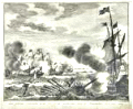 | Details | Tirion, Isaac | 1752 |
| Zes galeien overzeild en in den grond geshooten |
|
Tirion, Isaac |
|
| 1752 |
| LOC:1 |
| $200.00 | Tirion--Isaac | Zes-galeien-overzeild-en-in-den-grond-geshooten | Fine antique engraving by Isaac Tirion of an encounter between Dutch ships and eight Spanish galleys on October 3, 1602 in the English Channel off the coast of Dover. The galleys proved to be no match for the larger Dutch ships. In that battle three Spanish galleys were lost. |
| 4875 | 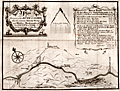 | Details | Eyes, John | 1758 |
| River Calder between Sowerby and Halifax |
|
Eyes, John |
|
| 1758 |
| LOC:88 |
| $250.00 | Eyes--John | River-Calder-between-Sowerby-and-Halifax | Map of the course of the Calder River between Sowerby Bridge and Halifax Brooks mouth by John Eyes. January, 1758. Includes towns and hamlets of Mermaid and Norland Town.
<br></br>
Now part of the Calder and Hebble Navigation suitable for vessels up to 14 feet in width.
<br></br>
John Eyes was a Liverpool surveyor, active 1740-1758, well known for his work surveying the Dee estuary. Eyes' four charts of the Lancashire coast from 1738 are said to be the first charts to show Greenwich as the Prime Meridian. (Skempton, Alec ed. Biographical Dictionary of Civil Engineers, Vol 1. p.220)
<br></br>
J. Evans sculpt. Liverpool. |
| 255 | 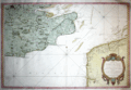 | Details | Bellin, Jacques Nicolas | 1759 |
| Carte du Comte de Kent et du Pas de Calais |
|
Bellin, Jacques Nicolas |
|
| 1759 |
| LOC:0 |
| $0.00 | Bellin--Jacques-Nicolas | Carte-du-Comte-de-Kent-et-du-Pas-de-Calais | SOLD
<BR> </BR>
Full colored old antique nautical chart produced by the Depot de la Marine in 1759. This chart, produced by J.N. Bellin, covers many areas of historical importance including the English Channel, and the Thames river as far as London, Dover, Calais, Beachy Head, Dunkirk. Good coverage of inland cities, towns, and road in England including New Haven. Croydon, Bromley, Deal, Sandwich, Rochester and many, many more. Numerous soundings and details of the sandbanks near Dover, Dunkirk, and the entrance to the Thames River. Highly decorative dated cartouche at bottom right. |
| 504 |  | Details | Beaurain, Jean | 1760 |
| Carte de la Manche |
|
Beaurain, Jean |
|
| 1760 |
| LOC:0 |
| $0.00 | Beaurain--Jean | Carte-de-la-Manche | SOLD<br></br>
Highly decorative chart of the English Channel by Jean Chevalier de Beaurain after the observations of Edmund Halley. Coverage includes from the Scilly Islands off the tip of Cornwall to past the Pas du Calais and Gravelines. At 42" in width this two sheet chart is an impressive artifact of a time when Britain ruled the waves. With three colored compass roses, rhumb lines, numerous soundings, and eight diagrams of maritime and navigational subjects.<BR> </BR>
Locates hundreds of towns and geographical landmarks on the South Coast of England and West Coast of France including Southampton, Poole, Cape Lizard, the Isle of Wight, Beachy Head, Plymouth, Brest; the Isles of Jersey, Guernsey, and Sark; Rouen, and Amiens. Dated 1760 in a decorative cartouche covered in roses.<BR> </BR>
Clockwise from the top left are a number of insets containing nautical definitions and drawings including: <BR>
-The offshore and tidal currents and their visual representation on the chart with arrows.<BR>
-Ancient and modern nautical logs (used to approximate the speed of a vessel over water).<BR>
-The use of the mariner's cross staff (l'Arbalestre) for measuring the altitude of the sun.<BR>
-The ship's wake or 'sillage'.<BR>
-The sounding lead (la sonde) for measuring water depth and the composition of the sea floor.<BR>
-The planisphere and a description of the earth's rotation.<BR>
-A simple astrolabe.<BR>
-The compass and compass card.<BR>
Martinet Inv; Vallet Script. |
| 17 |  | Details | Collins, Greenvile | 1760 |
| The Isle of Man |
|
Collins, Greenvile |
|
| 1760 |
| LOC:0 |
| $0.00 | Collins--Greenvile | The-Isle-of-Man | SOLD<BR></BR>
This beautiful antique nautical chart of the Isle of Man c. 1760 is depicted with rhumb lines, soundings, an ornamental title cartouche and two sailing vessels. Features a view of Peel Castle in upper right. From one of the many editions of Greenville Collin's 'Great Britain's Coasting Pilot', published from 1693 to 1792.<BR> </BR>
Strong graphic composition and attractive subdued coloring make this nautical chart an excellent candidate for display and decoration. Inscribed: "To the Right Honorable William Earle of Derby, Lord of Ye Isle of Man & This map is humbly dedicated by Capt. G. Collins." Oriented North to right of chart. |
| 121 |  | Details | Collins, Greenvile | 1763 |
| Newcastle upon Tyne |
|
Collins, Greenvile |
|
| 1763 |
| LOC:0 |
| $0.00 | Collins--Greenvile | Newcastle-upon-Tyne | SOLD <BR> </BR>
Three hand colored charts on a single sheet of heavy wove paper. Largest section is devoted to the Tyne river from the sea to the town of Newcastle. Two inset charts continue provide additional coverage on either side of the Tyne River: one of the coast near Sunderland and the other of Blyth Harbor. <BR> </BR>
With a large dedicatory cartouche to Trinity House. Trinity House, founded under royal charter in 1514 had three primary functions: maintenance of lighthouses and other aids to navigation, pilotage authority for more than 40 ports, and was a charitable organization for mariners. This chart clearly locates daymarks and buoys, information that is often not included in charts from this period. |
| 627 | 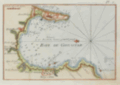 | Details | Roux, Joseph | 1764 |
| Bay of Gibraltar and Algeciras |
|
Roux, Joseph |
|
| 1764 |
| LOC:4 |
| $200.00 | Roux--Joseph | Bay-of-Gibraltar-and-Algeciras | Attractive antique nautical chart by Joseph Roux of the environs around the Bay of Gibraltar in the southwest Mediterranean Sea.
<BR> </BR>
This small original copperplate-engraved chart covers from the British Overseas Territory of Gibraltar in the east to the town of Algeciras in the west with plentiful soundings, sea hazards, and anchorages identified. Named features include numerous lookout towers, Rio Guadarranque ( Cuaranque ), Rio Palamones ( Riviere des Promones ), Fort St. Roch, Fort St. Philippe. Oriented with north to the left. <BR> </BR>
There were at least four small atlases of port and coastal charts that originated from Marseille hydrographers in the 18th century. Beginning in approximately 1727 these atlases included works by cartographers
<a rel="nofollow" href= "/MichelotBremondBackground.aspx"> Michelot and Bremond</a>,
<a rel="nofollow" href= "/Creator/Ayrouard--Jacques"> Jacques Ayrouard</a>,
<a rel="nofollow" href= "/Creator/Roux--Joseph"> Joseph Roux</a>
, and Jean Allezard. This small original chart is from the atlas of Mediterranean ports produced by Joseph Roux - "Recueil des Principaux Plans des Ports et Rades de la Mer Méditerranée". Plate 2. |
| 468 |  | Details | Lodge, J. | 1780 |
| Facing Cannon |
|
Lodge, J. |
|
| 1780 |
| LOC:50 |
| $150.00 | Lodge--J- | Facing-Cannon | Copperplate engraving depicting design and cutaway views of a British field cannon ca. 1780 by London engraver John Lodge. This 18th century engraving shows three views of a highly decorated cannon measuring over 11 feet long, adorned with many decorations including the British royal arms and two dolphins (lifting handles) mounted above the trunnions. Includes two side elevation views of cannon on field carriages. A small detail on the drawings shows the arrangement of a "burning glass" or magnifying glass on the touch-hole that could be used to fire the cannon. |
| 467 |  | Details | Hogg, Alexander | 1782 |
| System of Naval Architecture- Shipping |
|
Hogg, Alexander |
|
| 1782 |
| LOC:0 |
| $0.00 | Hogg--Alexander | System-of-Naval-Architecture--Shipping | SOLD
<br></br>
Several detailed steel-engraved drawings of a three-masted square-rigged ship.
<br></br>
Published as the Act directs by Alex. Hogg at the King's Arms, No. 16. Paternoster Row. Plate 126. |
| 196 | 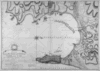 | Details | Faden, William | 1783 |
| Plan of the Bay Rock and Town of Gibraltar |
|
Faden, William |
|
| 1783 |
| LOC:66 |
| $750.00 | Faden--William | Plan-of-the-Bay-Rock-and-Town-of-Gibraltar | This beautifully engraved plan of the Bay and Rock of Gibraltar and Algeciras by William Faden details the disposition of military forces of France, Spain, and England during the great Siege of Gibraltar during 1779 - 1783, specifically in 1782. Details include the town, fortifications and the location and movement of the Spanish fleet's "forty-nine sail of the line", fire-ships, and battering ships <BR> </BR>
Hydrographic details in this antique map include current flow and numerous soundings. Remarkably extensive hachuring is used throughout the land areas to convey differences in elevation and topography. This chart/map must have required considerable effort by Faden to engrave. Faden promotes the accuracy of the map though his assurance in the title that it is based on a first-hand survey made between 1769 and 1775. Publication date in title of January 26, 1783 by William Faden. Number "24" printed on otherwise blank verso. |
| 429 |  | Details | Senex, John | 1786 |
| Celestial Globe |
|
Senex, John |
|
| 1786 |
| LOC:1 |
| $90.00 | Senex--John | Celestial-Globe | Small delicate copperplate engraving of a John Senex armillary sphere possibly by Guthrie. Senex (1690-1740) was a successful London Fleet-street engraver and globe maker. |
| 780 | 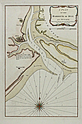 | Details | Sayer, Robert | 1789 |
| Antique nautical chart of the Harbor of Rye in Sussex, England |
|
Sayer, Robert |
|
| 1789 |
| LOC:89 |
| $425.00 | Sayer--Robert | Antique-nautical-chart-of-the-Harbor-of-Rye-in-Sussex--England | Beautiful antique nautical chart/plan depicts the coast of Kent and nearby towns of Rye and Playden ( Playdon ), England along with the Rye Camber and part of the Romney Marshes. This scarce harbor chart by Robert Sayer was published in 1789 and shows the navigational channel to Rye harbor marked by beacons as well as numerous soundings at high and low water. Noted features include Winchelsea Castle, Stoney Beach, the East Bar, Wenneway River, Camber Point, Guildford Gut, Black Shore, and a single windmill between Rye and Playden.
<br></br>
Sayer borrowed heavily from a chart published earlier by Greenville Collins. Two obvious differences are that the Romney Marsh in Collin's chart is here labeled 'Walland Marsh' and in this chart the town called Playdon is called 'Socket' on Collins'. Sayer's chart carries this additional note not found on Collin's chart: "A flag by day & a light by night are hoisted on the west pier-head of the new harbour of Rye, whenever there are nine feet water at the mouth of the harbour."
<br></br>
With a colorful compass rose. Published by Robert Sayer, Map and Chart-seller. 53 Fleet Street, London in "The Channel Pilot". Number 8 stamped in upper right corner. |
| 3595 | 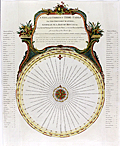 | Details | Laurie and Whittle | 1794 |
| Antique Tide Calculator for the North Sea, Bay of Biscay, and the English Channel |
|
Laurie and Whittle |
|
| 1794 |
| LOC:0 |
| $0.00 | Laurie-and-Whittle | Antique-Tide-Calculator-for-the-North-Sea--Bay-of-Biscay--and-the-English-Channel | SOLD <br></br>
Fine antique <b>volvelle for calculating the time of tides</b> at numerous locations in the UK and on the coast of Europe. A volvelle or wheel chart is a type of calculator constructed from paper. Essentially, a very early and simple analog computer. With a rotating dial for Locations and Minutes. Outside the rotating dial, are fixed a 30 Day Circle and a 12 Hours Circle and Names of Places including Lizard Point, The Coast of Flanders, Tinmouth Bar, Flamborough Head, Calais, the River of Bordeaux, and many more.
<br></br>
On this scarce device the instructions read <div class="indenttextblock">"To make use, you must place the Flower-de-Luce, or Index, to the Day of the Moon's age, on the circle of days and the Arrow, at the end of the line wherein the name is written, will point to the time of the Tides Flowing or Running that day, on the circle of hours."</div>
Published by Laurie & Whittle, 53 Fleet Street. March 12, 1794. |
| 124 |  | Details | Anonymous | 1795 |
| External and Internal Views of a first rate Ship of War. |
|
Anonymous |
|
| 1795 |
| LOC:1 |
| $165.00 | Anonymous | External-and-Internal-Views-of-a-first-rate-Ship-of-War- | A detailed copperplate engraving of a first rate British 'line of battle' ship with 3 gun decks. Shows full rigging and a below-decks cross-section. Includes detailed insets of the sail plan, yard rigging and the ship's chain pump. A good find as many similar ship views are steel-plate engravings that lack the character and warmth of this fine late 18th century example.
<br></br>
From Hall's Encyclopedia. |
| 181 |  | Details | Laurie and Whittle | 1798 |
| Plymouth Sound---- SOLD |
|
Laurie and Whittle |
|
| 1798 |
| LOC:0 |
| $0.00 | Laurie-and-Whittle | Plymouth-Sound-----SOLD | This item has been sold. <br></br>
Very cool antique nautical chart by Laurie and Whittle from 1798 of the Hamoaze and Catwater rivers, port of Plymouth, England and Plymouth Sound. Plymouth has a long distinguished history as a maritime port. This old sea chart of Plymouth Sound shows the location of many historic locations including a hill known as the Hoe, where legend says Francis Drake was to have insisted on completed a game of bowls before setting out to meet the invading Spanish Armada of 1588 led by the Duke of Medina Sidonia (Drake knew the tide was not in his favor at the time he was notified of the approaching Spanish fleet).<br></br>
Attractive title cartouche with date. Copious sailing directions, soundings, landmarks (especially churches), and navigational hazards are noted. The chart is an attractive record of the days when the town Plymouth was smaller in size, but no less important to England. |
| 338 | 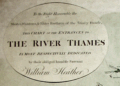 | Details | Heather, William | 1798 |
| The River Thames |
|
Heather, William |
|
| 1798 |
| LOC:0 |
| $0.00 | Heather--William | The-River-Thames | SOLD<BR> </BR>
Large colored antique navigational chart of the entrances to the Thames River with an inset showing the continuation of the Thames River from Erith to London. On heavy, chain laid paper. Numerous soundings and depictions of the well-knows sandbanks near the Thames mouth including "Kentish Knock", "Goodwin Sands", and the "Margate Sands". The Tower of London is noted and colored in red. Colored compass rose and rhumb lines. Coverage on this antique nautical chart includes parts of Essex, Kent, and Suffolk: Harwich, Dover, Milton, Stratford, Ipswich, Colchester and the entrance to the Medway river. <BR> </BR>
Dedication reads: "To the Right Honorable the Master, Wardens, and Elder Brethren of the Trinity Houfe, this Chart of the Entrances to the River Thames is Most Respectfully Dedicated by their obliged humble servant William Heather". Scales in English and French miles and Dutch Mylen. |
| 547 | 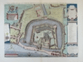 | Details | Society of Antiquaries of London | 1803 |
| Tower of London |
|
Society of Antiquaries of London |
|
| 1803 |
| LOC:64 |
| $500.00 | Society-of-Antiquaries-of-London | Tower-of-London | Splendid copperplate engraving of the Tower of London. An antique bird's-eye view of the Tower of London by the London Society of Antiquaries. A fine re-issue of a striking view created by Haiward and Gascoyne in 1597 and issued first in 1742. This edition on paper watermarked "1803".
<br><br/>
At top, below the royal coat of arms, is a scroll containing a compass rose and a dated attribution to the publishers in Latin :"Sumptibus Societatis Antiquaria Lond. MDCCXLII." At right are two scrollwork cartouches explaining the limits of the 'Tower Liberties' as they existed in 1597. Several dozen locations on the plan are keyed alphabetically to a legend at right. The tower is shown surrounded by a moat with a narrow fortified strip of land between the Tower and the Thames River. |
| 593 |  | Details | Depot de la Marine | 1804 |
| Plan du Port de Plymouth |
|
Depot de la Marine |
|
| 1804 |
| LOC:64 |
| $860.00 | Depot-de-la-Marine | Plan-du-Port-de-Plymouth | Neat chart of the harbor and town of Plymouth, England published in the 12th year of the French Revolution (1804). With shaded topographical details, numerous soundings, defensive structures, and navigational aids. Single profile view of the entrance to Plymouth Sound at top right.
<br></br>
Named features include Ram Head, Redden Point, Point Penlee, Saltash, Tamer River, Line River, East Anthony, Stoke Damerel, Plymouth, Sutton Pool, Mount Batten, Catwater, Causand Bay, Shagstone, Mewstone, Yealme River, Mill Bay, Drakes Island, and many more.
<br></br> Black and white copperplate-engraved chart was published by France's Depot de la Marine. With the circular anchor stamp of the Depot. Original price was one and one-half francs. |
| 434 |  | Details | Anonymous | 1804 |
| The Mariner |
|
Anonymous |
|
| 1804 |
| LOC:0 |
| $0.00 | Anonymous | The-Mariner | SOLD
<br></br>
Small etching depicting a British sailor holding an octant, titled "The Mariner". From "The Book of Trades, or Library of the Useful Arts"; Part 1. Published by Tabart & Co. London 1804. Matted with archival materials. |
| 435 |  | Details | Anonymous | 1804 |
| The Shipwright |
|
Anonymous |
|
| 1804 |
| LOC:0 |
| $0.00 | Anonymous | The-Shipwright | <BR> </BR>
SOLD
<BR> </BR>
Small etching depicting a British ship-yard worker with a caulking hammer at work pounding pegs into the hull of a wooden vessel. Titled "The Shipwright" this 200+ year old work is from "The Book of Trades, or Library of the Useful Arts"; Part 1. Published by Tabart & Co. London 1804. Matted with archival materials. Overall size with the mat is about 8"x10". |
| 4940 | 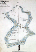 | Details | Anonymous | 1809 |
| Manuscript chart of the island of Diego Garcia |
|
Anonymous |
|
| 1809 |
| LOC:200 |
| $975.00 | Anonymous | Manuscript-chart-of-the-island-of-Diego-Garcia | French manuscript chart of the island of Diego Garcia. Diego Garcia, a coral atoll, is the largest and southernmost member of the Chagos Archipelago, in the central Indian Ocean.
<br/><br/>
Dated on or near May 2, 1809 when the French Governor of Mauritius Decaen granted rights over the island to Cayeux, the Didier brothers, and Lapotaire. Lapotaire was reported to have over 100 slaves working his copra plantation in 1809. The map clearly shows those three land holdings, with Didier at the southern end of the island. (Cawley, Charles. Colonies in Conflict: The History of the British Overseas Territories. Cambridge Scholars Publishing. 2015.)
<br/></br/>
"Portuguese explorers discovered Diego Garcia in the early 1500s. The islands remained uninhabited until the 18th century when the French established coconut and copra plantations with the help of slave labor. Diego Garcia became a possession of the United Kingdom after the Napoleonic wars, and from 1814 to 1965, it was a dependency of Mauritius."
(Source: https://www.cs.mcgill.ca) |
| 2549 | 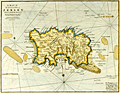 | Details | Stockdale, John | 1810 |
| A Map of the Island of Jersey in the English Channel. |
|
Stockdale, John |
|
| 1810 |
| LOC:88 |
| $0.00 | Stockdale--John | A-Map-of-the-Island-of-Jersey-in-the-English-Channel- | SOLD<br></br>
Early original copper-plate engraved map of Jersey Island one of the Channel Islands and a Crown dependency. Attractive antique engraved sheet.
<br></br>
The map was published by John Stockdale in London on the 26th of March 1805. This is a later printing ca. 1810 as demonstrated by the watermark "1809". Engraved by the prolific John Cary. |
| 889 | 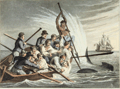 | Details | Clark, John Heaviside | 1813 |
| Antique aquatint of Killing a Shark |
|
Clark, John Heaviside |
|
| 1813 |
| LOC:1 |
| $95.00 | Clark--John-Heaviside | Antique-aquatint-of-Killing-a-Shark | First edition of this scarce hand-colored aquatint by <b>John Heaviside Clark</b> (1771-1836) in "Foreign Field Sports, Fisheries, Sporting Anecdotes…". In this fine engraved print from 1813 a small boat, overloaded with ship's crew pull a sailor to safety while another sailor prepares to drive a lance through the head of the shark.
<br></br>
A short shark-catching anecdote describes the physiology and habits of the shark and then devotes most emphasis to the shark's terrifying appearance and ferocity, concluding with this story:
<div class="indenttextblock"> "The late Sir Brook Watson was, as is well known, rescued from the jaws of death at the very moment when they were extended to devour him. His situation was precisely similar to that of the young seaman represented in the Plate. While bathing, when a young man, he was pursued by a Shark; and his imminent danger being perceived by the ships company, a boat was immediately put off: before it arrived, however the Shark had snapped at its unfortunate victim, and carried off a leg and a part of the thigh. It was in the act of making a second seizure when a sailor struck it with a boat-hook, and drove it from the pursuit.
</div>
</br>
Published by Edward Orme from Bond Street London, on March 1, 1813. On paper bearing a watermark of 1811. |
| 890 |  | Details | Clark, John Heaviside | 1813 |
| Antique aquatint of Turtle Catching on Land |
|
Clark, John Heaviside |
|
| 1813 |
| LOC:1 |
| $145.00 | Clark--John-Heaviside | Antique-aquatint-of-Turtle-Catching-on-Land | First edition of this scarce hand-colored aquatint from 1813 by <b>John Heaviside Clark</b> (1771-1836) in "Foreign Field Sports, Fisheries, Sporting Anecdotes…". In this fine engraved print a ship's crew loads large <b>sea turtles</b> aboard a small boat in order to bring them to their waiting ship. On long voyages fresh meat could run out aboard ship so these turtles would have provided a valuable source of nourishment. In addition, the turtles could be kept alive until needed, solving the problem of maintaining a fresh supply of food in an era without refrigeration.
<br></br>
In an anecdote accompanying the plate, the author explains how the turtles are caught:
<div class="indenttextblock"> "The turtle catchers, from the month of September to January, repair to those parts of the coast which the turtles mostly frequent, and watch them on shore, where they deposit their eggs in the night-time. The usual way is, to turn them quickly on their backs, not giving them time to defend themselves, by throwing up sand with their fins; which they can do with such force as sometimes to blind their assailants. … When the turtles find it impossible to escape, they utter a sort of sigh and are said to shed tears."
</div>
</br>
Published by Edward Orme from Bond Street London, on July 1, 1813. A very similar plate to this one, purchased at the same time bears a watermark of 1811. |
| 401 |  | Details | Dupin, Charles | 1819 |
| Ports of England, Scotland, and Ireland |
|
Dupin, Charles |
|
| 1819 |
| LOC:0 |
| $125.00 | Dupin--Charles | Ports-of-England--Scotland--and-Ireland | Charles Dupin (1784-1873) a French mathematician and naval engineer. Observation of this French engineer during visits to the major ports in England. Contains extensive sections describing the state and construction of the Plymouth harbor breakwater and the Caledonian canal.<BR> </BR>
Contains an engraved sketch of "Plymouth Sound and Breakwater (7"x7") and a hand-colored plan and transverse section of the Plymouth Sound breakwater (4"x8").<BR> </BR>
London: Printed for Sir Richard Phillips and Co. Bride-court, Bridge-street. 1819.<BR> </BR> |
| 409 | 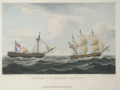 | Details | Ralfe, James | 1820 |
| Capture of La Furieuse |
|
Ralfe, James |
|
| 1820 |
| LOC:0 |
| $190.00 | Ralfe--James | Capture-of-La-Furieuse | Depicts the British vessel Bonne Citoyenne towing the Furieuse after defeating her in an eight hour battle. Hand-colored aquatint engraving from James Ralfe's 'The Naval Chronology of Great Britain'. Matted and framed.
<BR> </BR>
Attribution line: "Pub'd. By Pyall & Stroud, 19 Hanway Street Oxford Street." On wove paper with watermark "1825". |
| 414 | 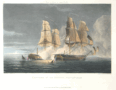 | Details | Ralfe, James | 1820 |
| Capture of La Thetis |
|
Ralfe, James |
|
| 1820 |
| LOC:0 |
| $0.00 | Ralfe--James | Capture-of-La-Thetis | SOLD
<BR> </BR>
Hand-colored aquatint engraving depicts the capture of 40-gun French frigate La Thetis by the British 36-gun frigate Amethyst. From James Ralfe's 'The Naval Chronology of Great Britain'.<BR> </BR>
Attribution line: "Pub'd. By Pyall & Stroud, 19 Hanway Street Oxford Street." On wove paper . |
| 415 | 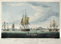 | Details | Ralfe, James | 1820 |
| The Prometheus and Melpomene |
|
Ralfe, James |
|
| 1820 |
| LOC:0 |
| $190.00 | Ralfe--James | The-Prometheus-and-Melpomene | Matted and framed.
<BR> </BR>
Antique hand-colored aquatint engraving depicts the day following a battle in which the Melpomene, Implacable, Bellerophon, and Prometheus captured six Russian gunboats and 12 supply vessels near Percola Point, Frederikshavn, Denmark.<BR> </BR>
From James Ralfe's 'The Naval Chronology of Great Britain'. Attribution line: "Pub'd. By Pyall & Stroud, 19 Hanway Street Oxford Street." On wove paper . |
| 416 | 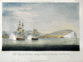 | Details | Ralfe, James | 1820 |
| The Imperieuse and Thames attacking a Castle and Gunboats |
|
Ralfe, James |
|
| 1820 |
| LOC:0 |
| $0.00 | Ralfe--James | The-Imperieuse-and-Thames-attacking-a-Castle-and-Gunboats | SOLD<br></br>
Hand-colored aquatint engraving depicts two British ships, 38-gun frigate Imperieuse and 32-gun Frigate Thames, in the harbour of Palinuro on the coast of Calabria in November 1811. The ships sank two gunboats and captured the fort after a just 15 minutes of shelling, and took two gunboats and 22 smaller vessels as prizes.<BR> </BR>
From James Ralfe's 'The Naval Chronology of Great Britain'. Attribution line: "Pub'd. By Pyall & Stroud, 19 Hanway Street Oxford Street." On wove paper . |
| 417 | 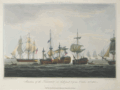 | Details | Ralfe, James | 1820 |
| Situation of the Temeraire |
|
Ralfe, James |
|
| 1820 |
| LOC:0 |
| $0.00 | Ralfe--James | Situation-of-the-Temeraire | SOLD
<br></br>
Matted and framed.
<BR> </BR>
Hand-colored aquatint engraving depicts the 98-gun British ship HMS Temeraire on October 21, 1805 at the battle of Trafalgar off the coast of Cape Trafalgar, Spain.<BR> </BR>
From James Ralfe's 'The Naval Chronology of Great Britain'. Attribution line: "Pub'd. By Pyall & Stroud, 19 Hanway Street Oxford Street." On wove paper . |
| 418 | 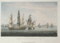 | Details | Ralfe, James | 1820 |
| Capture of La Sparviere, May 3rd 1810. |
|
Ralfe, James |
|
| 1820 |
| LOC:0 |
| $190.00 | Ralfe--James | Capture-of-La-Sparviere--May-3rd-1810- | Hand-colored aquatint engraving depicts the British 46-gun Spartan capturing the French vessel Sparviere in the Bay of Naples in 1810.<BR> </BR>
From James Ralfe's 'The Naval Chronology of Great Britain'. Attribution line: "Pub'd. By Pyall & Stroud, 19 Hanway Street Oxford Street." On wove paper . |
| 5466 | 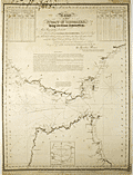 | Details | Reiner, Ignatius | 1824 |
| Rare chart of the Strait of Gibraltar by Reiner with tides and currents |
|
Reiner, Ignatius |
|
| 1824 |
| LOC: |
| $3,000.00 | Reiner--Ignatius | Rare-chart-of-the-Strait-of-Gibraltar-by-Reiner-with-tides-and-currents | A very rare chart by Ignatius Reiner, a chart of the Strait of Gibraltar published by Reiner and by John Purdy in 1824. Rare, the only recorded holding of the chart is at the British Library, London and no sales of any printed chart by Ignatius Reiner are recorded in the AMPR. With a small inset chart of the Bay of Tangier.
<br></br>
Reiner describes himself as "Pilot of the Schooner Pacifico, charged with the correspondence between Gibraltar and Barbary, in the years 1818, 19, 20, &c."
<br></br>
Upper left and right with tide tables for the European coast and the African coast respectively.
Engraved by Alex Findlay, Pentonville, London. Attribution at bottom reads:<div class="indenttextblocksingle"> "Published by the author Ignatius Reiner, at Gibraltar; and for him by John Purdy, Took's Court, London. 1st Dec. 1824."</div><br>
Well-executed mid 20th-century conservation with the chart laid to fresh linen and protected via a thin-film lamination process to both recto and verso. |
| 399 |  | Details | Barker, Matthew Henry | 1826 |
| Greenwich Hospital |
|
Barker, Matthew Henry |
|
| 1826 |
| LOC:0 |
| $400.00 | Barker--Matthew-Henry | Greenwich-Hospital | Collection of humorous nautical tales written by Matthew Barker and illustrated by George Cruikshank. Eleven etched plates and sixteen text woodcuts. Marbled boards. London: James Robins and Co., 1826 |
| 335 |  | Details | Meyer, C. | 1828 |
| Gibraltar (Manuscript plan) |
|
Meyer, C. |
|
| 1828 |
| LOC:8 |
| $610.00 | Meyer--C- | Gibraltar--(Manuscript-plan) | Unique manuscript military/engineering architectural plan of the Landport (northern) defences of the fortress at Gibraltar from the Inundation, past the Devil's Tongue battery, and the old mole. Two cross sections, one through the north wall (with measurements) and one through the west wall. A high degree of detail shown about the bastions and cannon emplacements. <br></br>
Several dozen measurements in miniscule red script. Contains a small sketch of what appears to be a cave entrance. With watermark "Whatman 1828". Signed "Egina der 7 September 1828 C. Meyer". |
| 304 | 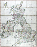 | Details | Cary, John | 1828 |
| Cary's Reduction of his Six Sheet Map of the British Isles |
|
Cary, John |
|
| 1828 |
| LOC:0 |
| $450.00 | Cary--John | Cary-s-Reduction-of-his-Six-Sheet-Map-of-the-British-Isles | Large, beautifully hand-colored antique folding map of the entire British Isles. John Cary's first map of the post roads, dated 1828. Good example of this map first published in 1796. Inset at upper right of the Shetland Isles. Maritime features include: the Atlantic Ocean, the German Ocean, the North Sea, the Irish Sea, St Georges Channel, and the English Channel.
<br></br>
Hand colored, dissected, and backed unto linen when issued. Folds into 42 parts. Marbled endpapers and complete with a green marbled slipcase to match that is labeled "Cary's two-sheet map of the United Kingdom." Published by G. and J. Cary, 86 St. James Street, London. |
| 431 | 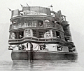 | Details | Cooke, E.W. | 1829 |
| The Circular Stern of His Majesty's Ship Asia. |
|
Cooke, E.W. |
|
| 1829 |
| LOC:0 |
| $0.00 | Cooke--E-W- | The-Circular-Stern-of-His-Majesty-s-Ship-Asia- | SOLD<BR> </BR>
Beautiful antique etching by Edward William Cooke (1811-1880) of the decorated stern of a Royal Navy ship, the HMS Asia. This fine, strong print from Cooke's "Fifty plates of Shipping and Craft" presents a view of the ship's stern with more than a dozen cannon run out , some obviously protruding from windows in the cabins of the Captain and other officers of rank.
<BR> </BR>
The Asia, a Canopus-class vessel, based on a French design, was built in 1824 by Bombay Shipyard. A ship-of-the-line, the Asia served at the Battle of Navarino in October 1827. The ship was the flagship of Vice-Admiral Edward Codrington. The Asia was broken up in 1908, a long lifetime for a wooden ship.
<BR> </BR>
From Cooke's early book of etchings of ships and other maritime subjects "Fifty Plates of Shipping and Craft". |
| 508 |  | Details | Cruikshank, George | 1835 |
| The Sailors Progress |
|
Cruikshank, George |
|
| 1835 |
| LOC:9 |
| $165.00 | Cruikshank--George | The-Sailors-Progress | Naval-themed frontispiece to a series of eight British naval caricature engravings by George Cruikshank depicting the life of Master Blockhead. Copperplate etching published by Thomas McLean, 26 Haymarket, London. August 1, 1835. Printed on an 11"x17" sheet of heavy wove paper the etching measure 5" by 7". |
| 518 | 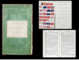 | Details | Greenwood, James | 1851 |
| The Sailor's Sea-Book |
|
Greenwood, James |
|
| 1851 |
| LOC:0 |
| $0.00 | Greenwood--James | The-Sailor-s-Sea-Book | SOLD
<br><br>
Three colored plates of flags (small loss to first page). **Contains a lone-star flag for Texas. Navigation treatise is comprised of two parts: 1) How to keep a log and work it off. 2) On finding the latitude and longitude.<BR> </BR>
Dictionary contains hundreds of definitions of terms used in ship building.
<BR> </BR> Published by John Weale. London. 59 High Holborn. |
| 287 |  | Details | Peake, James | 1851 |
| Rudiments of Naval Architecture |
|
Peake, James |
|
| 1851 |
| LOC:0 |
| $0.00 | Peake--James | Rudiments-of-Naval-Architecture | SOLD<br></br>
Rare antique book on wooden shipbuilding with dozens of in-line illustrations of construction details. Published in London in 1851 this small antique volume contains tables of scantlings and of relevant details for first-rate through sixth-rate ships of the line and for sloops. For each category of vessel: principal dimensions, number and weight of armament, weight of principal cables, description and weight of all masts and yards. 3 folding plates.<BR> </BR>
Tiny booksellers label on inside cover for "W. Campbell's Book and Stationery Warehouse, 324 Argyle Street, Glasgow. 174 pages. |
| 473 |  | Details | Gillray, James | 1851 |
| End of the Irish Invasion |
|
Gillray, James |
|
| 1851 |
| LOC:9 |
| $195.00 | Gillray--James | End-of-the-Irish-Invasion | Re-strike satirical copperplate engraving from the original plate by one of England's finest 18th century artists and satirists, James Gillray. This engraving by James Gillray reflects the fear of invasion from France at the end of the 18th century, just a few years after the French revolution. The prospect of invasion by sea has threatened the British Isles several times beginning in Roman times, notably during the "Invincible Armada" sent by Spain in 1588. <BR> </BR>
The New York Public Library website explains the plate: <dir class="indenttextblock">"From the beginning of the conflict with France, the British feared a French invasion. In October 1796, the King warned against such a threat, which was dismissed by the Opposition as a fantasy. However, on December 15, 1796, a French force of 15,000 troops with an armada of ships, led by General Lazare Hoche, sailed from Brest and anchored in Bantry Bay off southern Ireland, assuming that their invasion would prompt a popular uprising against the British. Like the Spanish Armada two hundred years before, this plan was undone primarily by stormy weather. The winds in Gillray’s version emanate from (left to right) the mouths of Prime Minister Pitt, Secretary of War Henry Dundas, Foreign Secretary William Wyndham Grenville, and War Minister William Windham. One ship, Le Révolutionare with a Fox figurehead, is tossed by wind and waves, the L’Egalité is swamped, and the Whigs aboard The Revolutionary Jolly Boat appear doomed."</dir>
<BR>
Source: New York Public Library. Print Collection. No. 49.<BR> </BR>
Originally published in 1797 by Hannah Humphrey this plate is from the Henry Bohn restrikes printed from the original plates during 1845 to 1851. Printed on both sides of heavy wove paper, the other side contains another fine engraving by Gillray titled "The Lion's Share". |
| 474 |  | Details | Gillray, James | 1851 |
| The Hero of the Nile |
|
Gillray, James |
|
| 1851 |
| LOC:9 |
| $245.00 | Gillray--James | The-Hero-of-the-Nile | Re-strike caricature copperplate engraving from the original plate, by one of England's finest 18th century artists and satirists, James Gillray. Gillray's topic in this plate, first published in 1798, is one of Britain's naval heroes, Admiral Horatio Nelson (1758-1805). <BR> </BR>
Today, without an explanation many readers would not realize that this engraving is a caricature of Nelson, generally considered to be a great naval leader. The Greenwich Royal Museum explains Gillray's point of view:<i> " In contrast to other unquestioningly adulatory prints of Nelson’s victory at the Battle of the Nile, Gillray here sardonically points to the very large material rewards heaped upon Nelson as a result. Burlesquing the genre of heroic portraiture, he presents Nelson in solitary full-length, on deck and enveloped in smoke. Gillray draws attention to the diamond chelengk in Nelson’s hat, presented to him by the Sultan of Turkey, and in the adapted coat of arms below the main image satirizes his recent baronetcy. In November Nelson was created Baron Nelson of the Nile and Burnham Thorpe and was awarded a pension of £2000 a year. Gillray substitutes for the correct arms on the original shield a bulging purse and scroll inscribed ‘£2000 pr Ann’. Placed alongside Nelson’s motto ‘Palmam qui meruit ferat’ (Let he who has earned it bear the Palm), Gillray undermines the motto’s meaning, to question whether such a large material reward really is merited.</i><BR>
Source: National Maritime Museum, Greenwich, London. Collections.
<BR> </BR>
Originally published in 1798 this plate is a restrike by Henry Bohn printed from the original plates during 1845 to 1851. Printed on both sides of heavy wove paper, the other side contains another engraving, a biting satire by Gillray titled "Destruction of the French Collossus". Plate 211. |
| 475 |  | Details | Gillray, James | 1851 |
| St. George and the Dragon |
|
Gillray, James |
|
| 1851 |
| LOC:9 |
| $500.00 | Gillray--James | St--George-and-the-Dragon | Spectacular re-strike caricature copperplate engraving from the original plate, by one of England's finest 18th century artists and satirists, James Gillray. The quality of engraving and the dark impression, along with Gillray's composition, and large size make this a very striking and attractive work. <BR> </BR>
The scene depicts the royal St. George (King George III) rescuing Britannia from the fangs of the Monster of France (Napoleon). The king wears the uniform of his own regiment of Guards (the Blues). <BR>
Source: Wright, Thomas and Robert Harding. "Historical and Descriptive Account of the Caricatures of James Gillray" Google Books. P.242 <BR> </BR>
Originally published in 1805 this plate is a restrike by Henry Bohn printed from the original plates during 1845 to 1851. Printed on both sides of heavy wove paper, the other side contains another engraving, a satire by Gillray titled "The end of the farce of Catholic Emancipation". |
| 90 |  | Details | Becher, A.B. | 1852 |
| The Storm Compass or Seaman's Hurricane Companion |
|
Becher, A.B. |
|
| 1852 |
| LOC:0 |
| $0.00 | Becher--A-B- | The-Storm-Compass-or-Seaman-s-Hurricane-Companion | SOLD<br></br>
Interesting small antique booklet for the mariner explaining hurricanes with an emphasis on best practices to predict and avoid hurricanes. This hard-to-find practical guide includes log-book accounts of hurricanes as illustrative examples of the principles proposed by the author, a commander in the British Royal Navy.<BR> </BR>
Inside cover includes an illustrated advertisement for Henry Whipple and Son sellers of charts and nautical works. 56 pages including tables and diagrams. Embossed blue paper boards. |
| 458 |  | Details | Wilson, G.W. | 1857 |
| H.M.S. Impregnable |
|
Wilson, G.W. |
|
| 1857 |
| LOC:0 |
| $150.00 | Wilson--G-W- | H-M-S--Impregnable | Attractively framed by branches, this stereoview of the British second-rate ship of the line H.M.S. Impregnable from 1857 was created by Scottish photographer G.W. Wilson. All three gun decks are clearly visible as the ship sits at anchor in Hamoaze, near Plymouth, England. The Impregnable, a close copy of Nelson's "Victory" was launched in 1811 and later refitted as a guard-ship. She saw action in the bombardment of Algiers in 1816. From 1862 to 1886 the Impregnable was used as a training ship for British naval cadets.<BR> </BR>
With two cancelled U.S. revenue stamps on the verso. Number 313. Manuscript annotation on verso reads: "Rundlet 27". |
| 465 | 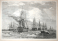 | Details | Anonymous | 1858 |
| The British Fleet at Spithead |
|
Anonymous |
|
| 1858 |
| LOC:0 |
| $0.00 | Anonymous | The-British-Fleet-at-Spithead | SOLD<br></br>
Very attractive woodblock engraving. Panoramic view shows warships from the British Navy under review at Spithead near the Isle of Wight at an early period in the transition from sail to steam power. Archivally matted. Dimensions with the mat are approx. 26" W x 20" H. Pages 146 and 147. From the London Illustrated News August 14, 1858. |
| 1203 | 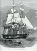 | Details | Illustrated London News | 1863 |
| Steam Corvette Racoon 22 Guns |
|
Illustrated London News |
|
| 1863 |
| LOC:0 |
| $130.00 | Illustrated-London-News | Steam-Corvette-Racoon-22-Guns | Fine wood engraving of the British Steam Corvette Racoon, 22 Guns. From the Illustrated London News published from London in 1863, during the hostilities to the west of the U.S. Civil War.
<br></br> Would frame nicely and present as a fine, thoughtful gift.
<br></br>
<div class="indenttextblock"> "Wood engraving is a printmaking and letterpress printing technique, in which an artist works an image or matrix of images into a block of wood. Functionally a variety of woodcut, it uses relief printing, where the artist applies ink to the face of the block and prints using relatively low pressure. By contrast, ordinary engraving, like etching, uses a metal plate for the matrix, and is printed by the intaglio method, where the ink fills the valleys, the removed areas. As a result, wood engravings deteriorate less quickly than copper-plate engravings, and have a distinctive white-on-black character." (Source: <a href="https://en.wikipedia.org/wiki/Wood_engraving" target="_blank">INTERNET</a> )
</div> |
| 5161 | 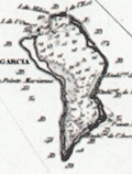 | Details | Depot de la Marine | 1870 |
| Antique French Chart of the Chagos Islands with Diego Garcia |
|
Depot de la Marine |
|
| 1870 |
| LOC:59 |
| $1,300.00 | Depot-de-la-Marine | Antique-French-Chart-of-the-Chagos-Islands-with-Diego-Garcia | Engraved antique nautical chart of the Chagos Island Archipelago, in the Indian Ocean, based on surveys of Moresby and Powell of the British East India Company. Published by the French Admiralty (Depot de la Marine) in 1841 with essential corrections in 1870.
<br></br>
The Chagos Island lie in the Indian Ocean about 300 miles south of the Maldive Islands. Diego Garcia, a United States military base, is located in the southeastern portion of the Chagos Archipelago.
<br></br>
Contains the circular anchor stamp of the Depot General de la Marine. With a black over-stamp, partially illegible but believed for "Cartes de la Marine Impériale. Debrie Libraire au Harve, Seul Depositaire."
<br></br>
Price: two Francs. Engraved by Chassant. Chart number 943. |
| 1296 | 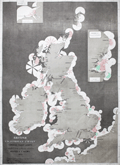 | Details | Hardinge, Woolfield | 1874 |
| Large rare antique British Lighthouse Chart |
|
Hardinge, Woolfield |
|
| 1874 |
| LOC:0 |
| $0.00 | Hardinge--Woolfield | Large-rare-antique-British-Lighthouse-Chart | SOLD <br></br>Very scarce and visually appealing "British Lighthouse Chart of General Coast Lights. Compiled from authentic sources by Woolfield H.F. Hardinge. 1874." This large ( 23" W x 32" H ) informational chart graphically displays these characteristics of the light: the range over which the light could be seen; frequency and duration of the light; and color of light. Includes lighthouses on both the Irish and British coastlines, with nearby French lighthouses shown along the English Channel.
<br></br>
Can not find any copy of this chart on the Internet or in AMPR.
<br></br>
Lithographed by Robert J. Cook and Hammond 29 Charing Cross S. W. Published by J. D. Potter, Admiralty Chart Agent 31 Poultry London, E.C. |
| 515 |  | Details | Pearson, George | 1874 |
| G. Pearsons General Tide Tables and Nautical Almanack for 1874 |
|
Pearson, George |
|
| 1874 |
| LOC:0 |
| $75.00 | Pearson--George | G--Pearsons-General-Tide-Tables-and-Nautical-Almanack-for-1874 | Small, scarce, 19th century nautical almanack published from Hartlepool, England. Blue paper covers. |
| 8034 | 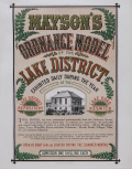 | Details | Mayson, Thomas | 1875 |
| Victorian exhibition advertisement for Mayson’s Relief Ordnance Model |
|
Mayson, Thomas |
|
| 1875 |
| LOC:89 |
| $200.00 | Mayson--Thomas | Victorian-exhibition-advertisement-for-Mayson’s-Relief-Ordnance-Model | Original Victorian exhibition advertisement for Mayson’s 3D Ordnance relief model of the Lake District, Cumbria, North West England, created in 1875 as a major visitor attraction in Keswick. The broadside announces the enormous 210 square foot model exhibited daily at the Lake District Repository on Lake Road, a sculpted landscape built to a scale of six inches to the mile and rendered with exactness from Ordnance Survey data. Bold Victorian lettering, fern motifs, and a vignette of the Repository building frame the promotional text, which highlights mountains, lakes, rivers, waterfalls, villages, and roads shown in full relief and hand colored to nature.
<br><br>
The model was commissioned by Keswick photographer Henry Mayson and his brother Thomas and built by the Italian sculptor Raffaelle Monti and his team using Ordnance Survey sheets as the mathematical basis for every contour. The advertisement stresses its practical value for travelers, noting that the model was an essential tool for planning excursions and understanding the correct topography of the Lake District at a time when tourism was rapidly increasing. Daily opening hours, illumination during summer months, and a one shilling admission charge appear prominently in the lower text block.
<br><br>
As an example of nineteenth century exhibition ephemera, this poster documents one of the most ambitious public relief models ever constructed in Britain and preserves the original marketing for a landmark Lake District attraction. Surviving advertisements for Mayson’s Ordnance Model are scarce, and this sheet stands as a desirable item for collectors of British posters, Lake District history, and early Ordnance Survey derived cartography. |
| 134 |  | Details | Anonymous | 1882 |
| Track Chart Anchor Line Transatlantic Service |
|
Anonymous |
|
| 1882 |
| LOC:0 |
| $90.00 | Anonymous | Track-Chart--Anchor-Line-Transatlantic-Service | Small antique ship's track chart of the Atlantic Ocean produced by the Anchor Line shipping company and used by passenger "Bertie Brown" to track his progress on a Transatlantic cruise. Details the daily position on a voyage from Ireland to New York departing September 29, 1882. Document on card stock folds into 3 parts. Front cover lists vessels owned by Anchor Line with their tonnage. With a profile view of a steamer underway. Expands to 10"x6". |
| 1053 | 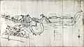 | Details | H.M. Board of Customs and Excise | 1883 |
| Manuscript Map of Thames Docks, Sufferance Wharves, and Uptown Warehouses |
|
H.M. Board of Customs and Excise |
|
| 1883 |
| LOC:0 |
| $0.00 | H-M--Board-of-Customs-and-Excise | Manuscript-Map-of-Thames-Docks--Sufferance-Wharves--and-Uptown-Warehouses | SOLD
<br></br>
Fascinating 19th century pen and ink manuscript map of the area now referred to as the <b>London Docklands</b>, a center for redevelopment and urban renewal. Includes the location of the recently constructed <b>Canary Wharf</b> business district in the bend of the Thames River called the Isle of Dogs (once referred to as Stepney Marsh). This antique manuscript map on linen covers the late 19th century quays, sufferage wharves, docks, and uptown warehouses that existed about 1883. Coverage of the upper map along the Thames River extends from above Southwark Bridge, past London Bridge and the Tower of London, and terminates at the entrance to the Royal Albert Dock about 11 miles south of London. An inset detailed map covers the City of London and Tower Hill districts to the east end of the London Docks.
<br></br>
Date of the map of 1883 is an estimate based on the fact that the Royal Albert Dock, which opened in 1880, is shown while the Tower Bridge, begun in 1886, is not shown. |
| 288 |  | Details | Depot de la Marine | 1895 |
| Cote est D'Irlande de la Baie de Dublin de la Baie de Belfast |
|
Depot de la Marine |
|
| 1895 |
| LOC:0 |
| $275.00 | Depot-de-la-Marine | Cote-est-D-Irlande-de-la-Baie-de-Dublin-de-la-Baie-de-Belfast | Interesting and uncommon folding 1895 edition (bottom of chart) of an antique nautical chart first printed in 1875. This intact linen-backed large folding chart of the Irish sea was published by the French Admiralty (Depot des Cartes et Plans de la Marine). Covers a wide area of Ireland and western portions of Britain including Belfast and Dublin , Isle of Man, and Holyhead Island. Lighthouses highlighted in yellow.<BR> </BR>
The antique chart folds to 5" x 9 1/2". Folds into 3 sections horizontally and 8 sections vertically. With a printed seller's sticker on front: " Maison Andriveau Goujon. Henry Barrere, Editeur-Geographe. 21 Rue du Bac, Paris". On the sticker below the seller's attribution is a script annotation of the chart title and a date of 1906.<BR> </BR>
Insets of the Port of Killough, Port of Ardglass, and a small view of the entrance to the Bay of Dundalk. Platemark is apparent but the chart is probably lithographic due to late 19th century provenance. Number 3460. Price: two francs. |
| 232 |  | Details | Bennet | 1900 |
| Sold--- Bennet's Map and Guide to the River Thames from Oxford to Gravesend |
|
Bennet |
|
| 1900 |
| LOC:0 |
| $0.00 | Bennet | Sold-------Bennet-s-Map-and-Guide-to-the-River-Thames-from-Oxford-to-Gravesend | SOLD<BR> </BR>
Scarce lithographed color map and advertising guide of the Thames River ca 1900. Fisherman's or traveller's map to this historic English river identifying numerous bridges, piers, and roads. Presence of the Tilbury Docks (built 1886) downstream from London dates the map to no earlier than 1886. |
| 135 |  | Details | Anonymous | 1902 |
| Track Chart Anchor Line American Mail Steamships |
|
Anonymous |
|
| 1902 |
| LOC:0 |
| $85.00 | Anonymous | Track-Chart--Anchor-Line-American-Mail-Steamships | Antique ship's track chart of Atlantic Ocean produced by the Anchor Line shipping company that was used by a passenger to track his progress on a Transatlantic cruise. Details the daily latitude and longitude on a 2689 mile voyage of the SS Anchonia between New York and Glasgow on Aug 9th - 19th, 1902. Daily position plots indicate a more northerly path than usual. <BR> </BR>
Document on card stock folds into 3 parts. Front cover lists vessels owned by Anchor Line with their tonnage and shows a frontal view of a steamer underway. Expands to 10"x6" |
| 516 | 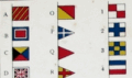 | Details | His Majesty's Stationery Office | 1908 |
| Signal Card 1908 |
|
His Majesty's Stationery Office |
|
| 1908 |
| LOC:41 |
| $95.00 | His-Majesty-s-Stationery-Office | Signal-Card-1908 | Small 4-page lithographed publication on 3 bound, heavy cards detailing signals used by Britain's naval forces: signal flags and pendants, semaphore, Morse signs, and flashing signs. HMSO, a commercial entity operated by the British government, was founded in 1786 to reduce costs by consolidating printing for the empire. Printed by M’Lagan and Cumming, Edinburgh. Price three pence. |
| 638 |  | Details | Merchant Navy Comforts Service | 1939 |
| On the Atlantic Front |
|
Merchant Navy Comforts Service |
|
| 1939 |
| LOC:0 |
| $0.00 | Merchant-Navy-Comforts-Service | On-the-Atlantic-Front | SOLD
<br><br/>
Early original WWII lithographed poster from 1939 depicting a merchant vessel running in heavy seas by artist Ellis Silas. <br><br/>
This old poster was produced by the Merchant Navy Comforts Service ( M.N.C.S. ) to garner donations for its activities in support of U.K. merchant seamen during the long battle with German submarines for the Atlantic Ocean. Message within the poster reads: <dir class="indenttextblock">" Send your thanks to the men who are winning the battle of the Atlantic by a donation to Merchant Navy Comforts Service, Appeal Headquarters: 62, Heath St. London, N.W.3."</dir>
<br><br/>
The Merchant Navy Comforts Service provided warm clothing, books, and other supplies to seamen. Of special interest were the emergency rescue kits that the M.N.C.S. provided to destroyers and other vessels that often rescued sailors from the icy Atlantic. Each kit contained 10 items of hand-knitted and store-bought clothing and it is reported that over a 2 year period 85,000 kits were distributed.
<br><br/>
Published by McCorquodale & Co. Ltd. London. |
| 6499 |  | Details | Anonymous | 1939 |
| Fine colorful map of Bermuda ca. 1939. |
|
Anonymous |
|
| 1939 |
| LOC:90 |
| $125.00 | Anonymous | Fine-colorful-map-of-Bermuda-ca--1939- | An original and very attractive 7"x21" pictorial map of the Bermuda Islands on the recto of a folding promotional brochure for Bermuda in four panels. Numerous simple realistic sketches depict locations that include:
<div class="indenttextblocksingle">
<ul style="list-style-type: circle;">
<li>Ireland Island</li>
<li>Gibbs Hill Lighthouse</li>
<li>St. Paul's Church</li>
<li>Military Barrack Prospect</li>
<li>Harrington Sound</li>
<li>Tucker's Town</li>
<li>Shelly Bay Race Track</li>
<li>St. George</li>
<li>St. Catherines Point</li>
</ul>
</div>Inset street plans for St. George and for Hamilton. North oriented at upper right with a fine colorful compass rose. Text below the map includes latitude and longitude coordinates for Bermuda and a scale of miles.
<br><br>
The verso contains photos and text related to steamship service to Bermuda from several maritime firms including:
<ul style="list-style-type: circle;">
<div class="indenttextblocksingle">
<ul style="list-style-type: circle;"></li>
<li>The Furness Bermuda Line</li>
<li>The Pacific Steam Navigation Company</li>
<li>The Munson Steamship Lines</li>
<li>The Canadian National Steamships</li>
<li>Elders & Fyffes, Ltd.</li>
<li>New York Bermuda Lines</li>
</ul>
</div> |
| 4836 | 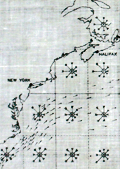 | Details | Navigators and Engineer Officers Union | 1942 |
| WWII Atlantic Survival Chart NEOU |
|
Navigators and Engineer Officers Union |
|
| 1942 |
| LOC:88 |
| $0.00 | Navigators-and-Engineer-Officers-Union | WWII-Atlantic-Survival-Chart-NEOU | SOLD<br><br>
Scarce, waterproof privately-published WWII survival map for the north Atlantic Ocean from 1942. Only one other copy of this chart is found online, attributed as a lifeboat chart. Odd that we don't see more of these charts. Published by the Navigators and Engineer Officers Union.
<br></br>
Although the Battle of the Atlantic had been underway since 1939 it was in January, 1942 that the first U.S. forces arrived in Britain and the first U-boats reached US waters, in total sinking almost 6,266,000 tons of shipping in 1942 alone. This chart, on waxed linen, was intended for use in a lifeboat or raft of an Allied vessel.
<br></br>
The front chart contains current indicators and arrow diagrams for indicating wind directionality and average wind speed. The chart was to be used:
<div class="indenttextblocksingle">
"1) By men on rafts to estimate their drift from a known position and to help in choosing a course of action. 2) By officers directing air-sea rescue operations to help in choosing the search area and the method of search."
</div>
<br />
The verso of the chart contains textual descriptions of "Average Fog Conditions Over the North Atlantic".
<div class="indenttextblocksingle">
"Issued by the Navigators and Engineer Officers Union in War-time service to Members with grateful acknowledgement to Messrs. Kelvin, Bottomley & Baird, Ltd. And Henry Hughes & Son for their assistance and help."
</div>
<br />
Published by the Navigators and Engineer Officers Union, 78 Leadenhall Street, London, E.C.3. The Navigators and Engineer Officers Union was formed in 1935 to take on the trade union functions of its predecessor Navigators and General Insurance Company Ltd. William Harry Coombs(1893-1969) served as the organization's General Secretary until 1943. (Longford, Mark. Navigators & General. Spring, 2011. Online). Bottom right corner: "M.B.F." |
| 6388 |  | Details | Phillips, Luther Savage | 1963 |
| Pictorial Map of Penobscot Bay Rare 2nd Edition |
|
Phillips, Luther Savage |
|
| 1963 |
| LOC:87 |
| $550.00 | Phillips--Luther-Savage | Pictorial-Map-of-Penobscot-Bay-Rare-2nd-Edition | Rare second edition of L. S. Phillips's (Luther Savage Phillips) 1940 first edition pictorial map of Penobscot Bay: "A Decorative Map of Penobscot Bay Region Showing the tidal coast of Maine from Camden to Blue Hill and Islesboro to Bangor."
<br><br>
This fine map is credited to Augustus D. Phillips, Luther's son, in 1963. Author attribution and dates are within, below left of the compass rose. Printed on quality laid paper.
<br><br>
No copies of A.D. Phillip's second edition are found online including WorldCat and AMPR. |
| 274 |  | Details | Fisher, Susanna | 2001 |
| The Makers of the Blueback Charts |
|
Fisher, Susanna |
|
| 2001 |
| LOC:0 |
| $0.00 | Fisher--Susanna | The-Makers-of-the-Blueback-Charts | SOLD <br></br>
Fine reference book on mapmakers from the City of London from 1750's to present. |