| | Thumbnail | | Creator | Date | Title / Author / Date / Location | Price | | | Description |
| 8090 |  | Details | Feher, Joseph | 1950 |
| The Dole Map of the Hawaiian Islands |
|
Feher, Joseph |
|
| 1950 |
| LOC:63 |
| $575.00 | Feher--Joseph | The-Dole-Map-of-the-Hawaiian-Islands | Original lithographed pictorial map of the Hawaiian Islands copyrighted by the Hawaiian Pineapple Company Ltd. 1950. Overall width 40.5 inches. Lacking original legend at right. Pinholes in margins.
<br><br>
Artist Joseph Feher depicted the Hawaiian islands and adjacent waters with boats, fish, and typical objects and pursuits associated with the islands: flying fish, surfing, spear fishing, sailing, poi-making, hula dancers, etc. Islands of the State of Hawaii mentioned in the legend include: Kauai, Niihau, Oahu, Molokai, Lanai, Maui, Kahoolawe, and the big island- Hawaii.
<br></br>
This is the second of two "Dole Pineapple Maps", the first was published in 1937.
<br></br>
Lithography by Schwabacher-Frey.
<br></br>
Once known as the Sandwich Islands, the Hawaiian Islands first documented discovery by a westerner occurred in 1778 with the arrival of British explorer Captain James Cook.
<br></br> |
| 8079 | 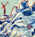 | Details | Sink, John | 1948 |
| Scarce pictorial map of western North Carolina |
|
Sink, John |
|
| 1948 |
| LOC:41 |
| $450.00 | Sink--John | Scarce-pictorial-map-of-western-North-Carolina | Western North Carolina: a vacationist's map and guide is a colorful mid-20th century pictorial map ca. 1948 illustrated by John Sink, a commercial artist known for lively regional tourist imagery. The map presents the Blue Ridge and Great Smoky Mountains as a continuous mountain chain extending from the Tennessee line eastward across western North Carolina ending at the Sauratown Mountains with Hanging Rock State Park.<br><br>
Peaks, gaps, and valleys are shown in bold, sculptural relief, while towns such as Asheville, Boone, and Bryson City anchor the geography. Cartoon figures hiking, skiing, fishing, and sightseeing animate the landscape, emphasizing recreation and leisure ("The Fun") rather than precise navigation.<br><br>
Designed as both a guide and a promotional image, the map combines expressive illustration with practical travel information. Major highways and scenic routes, including the Blue Ridge Parkway, trace the mountain ridges, while airplanes, automobiles, and roadside signage reflect the postwar rise of leisure travel by car and air. An inset conventional road map ("The Hiways") at lower right shows a detailed network of highways serving western North Carolina, reinforcing the sheet's function as both a souvenir image and a usable tourist guide.
<br><br>Text on verso with twelve proposed routes for scenic tours throughout the region. |
| 8041 |  | Details | Hall, Dick Wick | 1920 |
| Rare Salome Road Map by Dick Wick Hall Los Angeles to Phoenix |
|
Hall, Dick Wick |
|
| 1920 |
| LOC:89 |
| $1,450.00 | Hall--Dick-Wick | Rare-Salome-Road-Map-by-Dick-Wick-Hall-Los-Angeles-to-Phoenix | Very rare unrecorded, hand-drawn road map, issued as a blueprint, of central Arizona and California, west of Phoenix by promoter, humorist, publisher, columnist and entrepreneur Dick Wick Hall. Inset note for aviation landing fields, rare on road maps of this era. Hall's initials D.W.H. at bottom right corner.
<br><br>
<div id="0" align="center">
<a title=""></a>
<img id="8041" src="/ZoomifyImages/SC_8041/SC_8041_Frog.jpg" alt="Dick Wick Hall's Famous Salome Frog." width="300"/> <br><br> <font size="-2">Hall's Famous Salome Frog<br> At the Laughing Gas Station. Salome AZ.</font>
</div><br>
Dick Wick Hall founded Salome, Arizona in 1904 as part of a speculative desert development venture along a proposed railroad route in western Arizona. He soon became the town’s most visible booster, operating a roadside service station, promoting travel through the desert, and cultivating a larger-than-life persona that blended entrepreneurship with humor.
<br><br>
Dated to 1920 based on a very similar map published by Hall in his Salome Sun mimeographed newspaper he published between 1920 and 1926. <div class="indenttextblock"><i>" ... the paper was likely intended to be supplied to service stations, such as the one Hall owned in Salome, or other road stops for the traveler passing through, as each issue contains short quips written by Hall about road trips, Yuma County, stories about the desert and driving in the southwest. The paper also often contains cartoonish illustrations of common southwest wildlife, from snakes to scorpions and cacti, as well as regularly featuring a cartoon frog by the name of the Salome Frog who regularly declares that he cannot swim."</i> </div> (Reference: State of Arizona Research Library. Online. https://azmemory.azlibrary.gov/nodes/view/328579).<br><br> |
| 8036 | 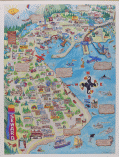 | Details | Nadon, Paul and Sandi | 1985 |
| Colorful pictorial advertising poster of Seward, Alaska |
|
Nadon, Paul and Sandi |
|
| 1985 |
| LOC:130 |
| $325.00 | Nadon--Paul-and-Sandi | Colorful-pictorial-advertising-poster-of-Seward--Alaska | Colorful pictorial poster map of Seward, Alaska, drawn by Paul and Sandi Nadon and published by New Sensations in 1985. The sheet presents the harbor town of Seward on Resurrection Bay as a busy cartoon landscape, with streets, businesses, and waterfront activity rendered in bright hand drawn vignettes rather than formal cartography. A large vertical Seward banner along the left margin, smiling sun over the Kenai Mountains, and playful notes in the margins firmly place the map in the late twentieth century tourist boom along the Alaska coast.
<br><br>
Within the town grid the artists label motels, cafes, shops, churches, and civic buildings, while the surrounding hills show wildlife, waterfalls, and campgrounds. The harbor is packed with cruise boats, fishing vessels, sailboats, and float planes coming and going from Resurrection Bay, all keyed to short text panels that highlight local attractions such as the Silver Salmon Derby. A puffin shaped compass rose, orcas, sea otters, and seabirds enliven the water, and humorous scenes on land convey the easygoing character of Seward as a working port and visitor destination.
<br><br>
More than a simple street plan, the poster functions as an illustrated directory of mid-1980s Seward, preserving the look of its downtown businesses, harbor facilities, and tourist culture at a particular moment in time. The map should appeal to collectors of Alaska ephemera, pictorial map posters, and American roadside tourism, it is an engaging wall piece that rewards close inspection, with dozens of local references and comic details scattered across the sheet.
<br><br> |
| 8020 |  | Details | White Mountain Graphics | 1981 |
| Illustrated Pictorial Map of Martha’s Vineyard |
|
White Mountain Graphics |
|
| 1981 |
| LOC:130 |
| $300.00 | White-Mountain-Graphics | Illustrated-Pictorial-Map-of-Martha’s-Vineyard | A colorful illustrated poster map of Martha's Vineyard drawn by K. Rinaldo and published in 1981 by White Mountain Graphics. The poster is filled with hundreds of hand-drawn vignettes capturing island towns, harbors, beaches, landmarks, and summer pastimes. The artist uses a cartoonlike style to show ferries approaching Vineyard Haven, sailboats in Katama Bay, lighthouses, beaches, farms, and well-known establishments across Oak Bluffs, Edgartown, and Chilmark. Inset scenes, handwritten labels, humorous details, and decorative border elements give the sheet the character of a personal visual tour rather than a formal cartographic product.
<br><br>
The map functions as a record of Vineyard culture, highlighting cottages, inns, restaurants, bicycle routes, fishing spots, and community traditions that defined the island during the period. Its composition rewards close viewing, with dozens of local references rendered in a bright palette intended to evoke the island's summer energy. A striking pictorial map for collectors of Vineyard ephemera and American resort-town cartography.
<br><br>
White Mountain Graphics was a small New Hampshire-based illustration and design studio active primarily in the late 1970s and early 1980s. Operating out of Jackson, New Hampshire, the firm produced a range of commercially printed posters, pictorial maps, and souvenir-oriented visual materials, often in a hand-drawn style similar to the Martha's Vineyard map.
<br><br> |
| 7999 | 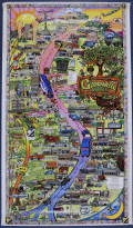 | Details | Landmark Adventures | 1992 |
| Greeville Avenue Dallas Texas Pictorial Map |
|
Landmark Adventures |
|
| 1992 |
| LOC:130 |
| $500.00 | Landmark-Adventures | Greeville-Avenue-Dallas-Texas-Pictorial-Map | This illustrated pictorial promotional poster map titled “Greenville Avenue: A Landmark Adventure – Dallas, Texas” depicts the full commercial corridor of Greenville Avenue using dense line-art drawings of individual businesses, landmarks, and street features. Drawn by Jack B. Weidner. Copyright Landmark Adventures, 1992-1993.
<br><br>The artwork organizes the avenue vertically, with north at the top, and identifies a large number of local establishments including restaurants, bars, boutiques, clubs, real-estate offices, and service businesses. Notable sites shown include the Doubletree Hotel, Old Town Shopping Center, Ada Art Gallery, Rollins, Corinthian Sailing Club, Pepe’s & Mito’s, The Diner, John’s Café, Flip’s, Nick’s Café, and many others. Corporate sponsors such as the Dallas Cowboys, Pepsi, Coors, RE/MAX, American Airlines, 94.5 The Edge, and Landmark Adventures appear within the composition, indicating commercial support at the time of publication. The map also includes playful vignettes—cars, pedestrians, musicians, hot-air balloons, aircraft, and neighborhood scenes—presented in a visually busy style meant to capture the character of the district.
<br><br>
Directional labels (Deep Ellum, McKinney Avenue), street names (Ross Avenue), and inset business directories help orient the viewer, while the border incorporates a decorative pattern consistent with late-20th-century pictorial map design. The poster functions as both a promotional guide and a snapshot of Greenville Avenue’s retail environment at the time it was created, documenting a concentration of independent businesses alongside well-known local institutions. As ephemera, it records the commercial identity of one of Dallas’s most recognizable streets and provides a detailed reference to storefronts and neighborhood culture that may no longer exist in the same form today. |
| 7995 |  | Details | Nadon, Paul | 1985 |
| Humorous pictorial map of Breckenridge, Colorado from 1985. |
|
Nadon, Paul |
|
| 1985 |
| LOC:130 |
| $450.00 | Nadon--Paul | Humorous-pictorial-map-of-Breckenridge--Colorado-from-1985- | This colorful pictorial poster map of Breckenridge, Colorado, created and signed by Paul Nadon, presents a detailed illustrated view of the town’s commercial core and surrounding mountain setting as it was in the mid-1980's. The drawing highlights Main Street and nearby blocks through individually rendered storefronts, lodges, restaurants, ski shops, and local businesses, each shown with distinctive architectural and graphic detail. The map functions as a stylized guide to the businesses of the period while offering a snapshot of Breckenridge during the mid-1980s. Copyright New Sensations, 1985.
<br><br>
Across the landscape, Nadon incorporates a wide variety of playful elements—skiers descending the slopes, hikers, wildlife, a hot-air balloon, a rainbow, and humorous scenes referencing local recreation. Hand-lettered notes provide bits of local history and commentary, while decorative banners and figures add to the informal, tourist-friendly tone of the piece. Despite the whimsical aesthetic, the arrangement of streets and buildings follows the real alignment of Main Street, Ridge Street, Park Avenue, and French Street.
<br><br>
Produced at a time when Breckenridge was expanding as a Rocky Mountain ski destination, the map captures the town’s commercial identity at a moment of growth. Its combination of detailed storefront depictions, vibrant illustrations, and personable local character makes it both a practical period guide and a visually engaging souvenir from 1980s Breckenridge.<br><br> |
| 7948 | 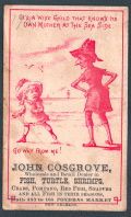 | Details | Cosgrove, John | 1880 |
| Trade Card for John Cosgrove Poydras Market New Orleans |
|
Cosgrove, John |
|
| 1880 |
| LOC:41 |
| $150.00 | Cosgrove--John | Trade-Card-for-John-Cosgrove-Poydras-Market-New-Orleans | Antique trade card advertising for John Cosgrove, a wholesale and retail dealer in fish, turtle, shrimps, crabs, pompano, red fish, snapper, and other seasonal fish at Poydras Market in New Orleans. Date is estimated as circa 1880.
<br><br>
The Poydras Market was a major public food market in 19th-century New Orleans, strategically located on Poydras Street near the Mississippi River and just west of the French Quarter. It was part of a network of municipal markets established to supply the city’s growing population with fresh produce, meats, and seafood. Its proximity to the riverfront made it an ideal site for offloading goods brought in by boat, especially the bounty of the Gulf—shrimp, crabs, pompano, redfish, turtle, and snapper were staples of the stalls.
<br><br>
The market was a bustling commercial hub where independent vendors, such as John Cosgrove, rented numbered stalls to sell seasonal goods. These vendors catered to a diverse clientele that included chefs, homemakers, and restaurateurs, all drawn by the variety and freshness of the offerings. The open-sided structure, typical of Southern markets, allowed for good airflow in the subtropical climate and fostered a lively, communal atmosphere filled with the sounds and scents of everyday commerce.
<br><br>
By the early 20th century, however, changes in transportation, refrigeration, and shopping habits began to erode the dominance of public markets. Poydras Market gradually declined and was eventually demolished—likely by the mid-20th century—as downtown New Orleans transformed into a modern commercial district. While the physical market is long gone, its name and legacy endure in the city’s culinary memory and in rare trade ephemera like this advertising card. |
| 7983 |  | Details | Hip Products | 1970 |
| Mid-Century Pop Art Peace Poster One Peace Missing |
|
Hip Products |
|
| 1970 |
| LOC:130 |
| $175.00 | Hip-Products | Mid-Century-Pop-Art-Peace-Poster-One-Peace-Missing | Vividly designed in the bold graphic style of the late 1960s, this unrecorded original black light poster features a stylized Earth composed of interlocking puzzle pieces, with one section shaped like a dove removed from the globe. The missing “piece” appears above, transformed into a green dove bearing a black peace symbol, carrying a cartoon-like figure in a space helmet. At lower right, the caption reads in block lettering: “THE WORLD IS A PUZZLE WITH ONE PEACE MISSING.”
<br><br>
This imaginative image reflects the optimism and visual wit of the 1960s counterculture art scene, combining Pop-Art color, psychedelic simplicity, and the peace iconography that became synonymous with the era’s anti-war movement. The use of flat, saturated color fields—blue, green, and brown—echoes mid-century silkscreen printing aesthetics.
<br><br>
Likely issued in the late 1960s or early 1970s, this poster exemplifies the visual language of the global peace movement, pairing humor and idealism in a single, striking composition. An excellent example of period graphic design appealing to collectors of mid-century poster art and peace memorabilia. |
| 7927 |  | Details | Rambo, Ralph | 1971 |
| Santa Clara Valley sample map letter price list of Ralph Rambo |
|
Rambo, Ralph |
|
| 1971 |
| LOC:41 |
| $325.00 | Rambo--Ralph | Santa-Clara-Valley-sample-map-letter-price-list-of-Ralph-Rambo | A group of three artifacts that capture the spirit of California’s “Valley of Heart’s Delight” as seen through the eyes of Ralph Rambo (1894–1990)—the artist, humorist, and historian who chronicled old Santa Clara before it became Silicon Valley. Included is an autograph letter signed “Ralph Rambo” on his personal printed letterhead, dated circa 1971, in which the 76-year-old Rambo discusses his experience designing and selling maps as a “retirement pastime.” Written in his distinctive hand, the letter reflects his entrepreneurial wit and warm tone as he advises a fellow enthusiast on the economics of map publishing: “You are getting the very last of these maps... a handsome profit in map selling IF you have something GOOD with a wide appeal.”
<br><br>
Accompanying the letter are a salesman's' sample of Rambo’s pictorial map, -- Cartoon Pen and Inklings of the Old Santa Clara Valley — and Rambo's original price list for his illustrated works, all housed together in their original mailing envelope bearing Rambo’s Santa Clara return address. Together these three pieces form an evocative snapshot of a regional artist at work, combining correspondence, cartographic art, and period ephemera. An appealing and uncommon ensemble for collectors of California history, pictorial maps, or mid-century American illustration, they provide a glimpse into Rambo the entrepreneur. |
| 7899 |  | Details | Greenville Avenue Area Business Association | 1992 |
| Pictorial Advertising Map of Greenville Avenue Dallas Texas |
|
Greenville Avenue Area Business Association |
|
| 1992 |
| LOC:141 |
| $300.00 | Greenville-Avenue-Area-Business-Association | Pictorial-Advertising-Map-of-Greenville-Avenue-Dallas-Texas | Large advertising poster of Upper Greenville Avenue, a vibrant neighborhood located in east Dallas, Texas, known for its diverse restaurants, lively entertainment scene, and walkable streets. Situated along Greenville Avenue, the area is home to a wide variety of dining options, ranging from casual eateries to upscale restaurants, as well as live music venues, bars, and pubs.
<br><br>
The neighborhood is surrounded by residential areas, primarily composed of single-family homes and apartments. Upper Greenville also features a mix of local boutiques, vintage stores, and specialty shops, catering to various tastes and interests. The area hosts several annual events, such as the Greenville Avenue St. Patrick's Day Parade and Block Party, which attracts thousands of visitors.
<br><br>
Copyright 1992-1993 Landmark Adventures. |
| 7884 |  | Details | Chase, Francis J. | 1959 |
| Pictorial Map of Alaska, the 49th State |
|
Chase, Francis J. |
|
| 1959 |
| LOC: |
| $295.00 | Chase--Francis-J- | Pictorial-Map-of-Alaska--the-49th-State | Ernest Dudley Chase's "A Pictorial Map of Alaska, the 49th State" is a fascinating visual representation of Alaska's history and its journey to statehood. The map, created in 1959, celebrates Alaska's admission to the Union as the 49th state on January 3 of the same year. Chase's signature style, combining attractive illustrations with geographical information, provides a unique perspective on this momentous event in American history.
<br><br>
The Chase's map incorporates an alphanumeric grid system to help users easily locate specific points of interest. Surprisingly, the map retains its original advertising sticker, prominently displayed in the upper left corner, bearing a price of 50 cents. The presence of the sticker serves as a testament to its authenticity, further enhancing its overall value and desirability.
<br><br>
The map showcases various aspects of Alaskan life, including its natural resources, industries, and cultural heritage. Chase depicts the state's diverse landscapes, from the rugged coastlines to the majestic mountain ranges, highlighting the beauty and vastness of America's last frontier.
<br><br>
Chase's map also chronicles the historical events leading up to Alaska's statehood, such as the purchase of Alaska from Russia in 1867, known as "Seward's Folly," and the discovery of gold in the late 19th century, which led to the Klondike Gold Rush. The map portrays the development of Alaska's major cities, including Anchorage, Fairbanks, and Juneau, as well as the growth of its industries, such as fishing, mining, and logging.
<br><br> |
| 7875 | 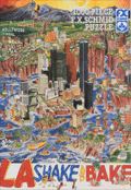 | Details | Holladay, John | 1992 |
| Rare Apocalyptic Los Angeles After Earthquake Puzzle |
|
Holladay, John |
|
| 1992 |
| LOC: |
| $385.00 | Holladay--John | Rare-Apocalyptic-Los-Angeles-After-Earthquake-Puzzle | Scarce and fun 1000 piece pictorial puzzle titled LA Shake and Bake, created in 1992 by illustrator John Holladay and published by F. X. Schmid. Puzzle is unopened in original shrink wrap as issued. <br><br>The puzzle presents a satirical pictorial view of Los Angeles shattered by a massive quake, with districts sliding toward the Pacific Ocean in a dense and humorous cartoon style. The image plays on long standing California earthquake lore. It was also issued by Schmid as an uncut poster. When assembled, the puzzle measures 26.5 by 17.25 inches.<br><br>
Holladay's theme draws on the popular misconception that California might someday break off along the San Andreas Fault, an idea that traces back to public misunderstanding of Andrew Lawson's 1906 report describing lateral motion after the San Francisco earthquake. His phrasing that the Pacific side moved northward relative to the American side echoed for decades, inspiring exaggerated public fears and giving artists like Holladay fertile ground for satirical disaster scenes. The puzzle captures that cultural myth with vivid color and a chaotic, engaging layout.<br><br>
LA Shake and Bake also reflects the long publishing history of F. X. Schmid, founded in Munich in 1860 and best known for toys, cards, and later board games and puzzles. By the 1970s and 1980s the company had expanded internationally, including a U.S. division that produced widely distributed puzzles like this one. Financial pressures in the mid 1990s led to a 1997 merger with Ravensburger, marking the end of Schmid as an independent maker. This puzzle stands as one of the imaginative late period Schmid releases, combining contemporary humor, geological lore, and striking packaging design.
<br><br>
Box size roughly 15.5" x10". |
| 7864 | 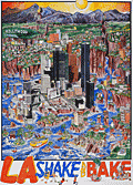 | Details | Holladay, John | 1992 |
| Pictorial Poster View of Los Angeles Submerged After Earthquake |
|
Holladay, John |
|
| 1992 |
| LOC:89 |
| $800.00 | Holladay--John | Pictorial-Poster-View-of-Los-Angeles-Submerged-After-Earthquake | Fine medium-format satirical poster of Los Angeles titled LA Shake and Bake, created in 1992 by illustrator John Holladay. Very rare, with no institutional holdings found in WorldCat and no recorded sales of the poster on the Internet. <br><br>The artwork presents a dramatic cartoon vision of the city shattered by a massive quake, with hills cleaving open, and whole neighborhoods transformed into islands in a rising blue sea. Holladay fills the sheet with humorous detail, from boats navigating through canyon walls to crowds celebrating on newly formed shorelines. The Hollywood Hills, downtown high rises, and coastal districts are all reimagined as fragments of a fractured landscape, creating a lively blend of regional caricature and disaster fantasy that reflects long standing popular myths about California earthquakes.<br><br>
Issued by Holladay Prints independent of the moderately rare F. X. Schmid puzzle edition (in stock 12/25), this poster allows the viewer to appreciate the full composition without the grid of puzzle cuts. The image captures the playful anxiety of early 1990s Los Angeles culture, shaped by real seismic events like the 1992 Landers sequence and by public misconceptions that California might one day fall into the Pacific. With its bright palette, dense pen work, and packed narrative scenes, LA Shake and Bake stands as a memorable example of late twentieth century pictorial satire devoted to one of America’s most iconic urban landscapes. |
| 6868 |  | Details | Anonymous | 1940 |
| Pictorial Map Metropolitan Oakland California Pre-war |
|
Anonymous |
|
| 1940 |
| LOC:89 |
| $300.00 | Anonymous | Pictorial-Map-Metropolitan-Oakland-California-Pre-war | Scarce unattributed pictorial map of the metropolitan Oakland, California. Likely dates to circa 1940 based on the aircraft style in one of the photographic vignettes and the fact that the Oakland Bay Bridge, built 1936, appears on the map. Unsigned and undated. |
| 6858 |  | Details | Graham County Arizona Chamber Commerce | 1940 |
| Pictorial Map of Gila Valley, Arizona |
|
Graham County Arizona Chamber Commerce |
|
| 1940 |
| LOC:89 |
| $315.00 | Graham-County-Arizona-Chamber-Commerce | Pictorial-Map-of-Gila-Valley--Arizona | Rare, humorous pictorial map of Gila Valley, Graham County, Arizona- The Valley of Smiles, circa 1940, drawn by artist Hal Empie. The map, on the verso of a folding brochure, shows pictograms reflecting Western culture all designed to attract visitors to the Gila Valley. At upper right the Gila Cliff Dwellings. Contains an interesting compass rose composed of Native American Indian Artifacts.
<br><br>
Towns included along Hwy. 70 as it follows the Gila River include: Bylas, Geronimo, Fort Thomas, Ashurst, Glenbar, Pima, Thatcher, and Safford, the seat for Graham County.
<br><br>
There were apparently two editions of this brochure, only one copy of the other (earlier ?) brochure with map was found online. No copy of this map or brochure found in WorldCat. |
| 6856 | 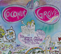 | Details | Blissberger, Linda | 1982 |
| Coconut Grove Poster Advertising Map |
|
Blissberger, Linda |
|
| 1982 |
| LOC:61 |
| $525.00 | Blissberger--Linda | Coconut-Grove-Poster-Advertising-Map | Scarce advertising poster map of Coconut Grove, Florida by artist Linda Blissberger. 1982.
<br><br>
"Designed by the Blissberger with the able assistance of the Bliss Bear while dodging bulldozers on Florida Ave. Jan. - Feb. '82. Blissberger Art & Airbrush Creations & Gallery of Surprises. 3425c Main Hwy. 445-3146." |
| 6759 | 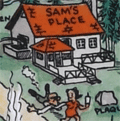 | Details | Clary, A. D. | |
| Pictorial map San Joaquin Power Club Wishon Cove Camp |
|
Clary, A. D. |
|
|
| LOC:89 |
| $250.00 | Clary--A--D- | Pictorial-map-San-Joaquin-Power-Club-Wishon-Cove-Camp | You have heard about "Where's Waldo?" but on this map I ask: "Where's Kilroy?"
<br><br>
An original post-WWII pictorial map of Wishon Cove Camp at Wishon Cove on Bass Lake in Crane Valley, California <b>featuring Kilroy</b> (1). Subtitled "San Joaquin Power Club", apparently this camp was originally a private club for the San Joaquin Power Company. Today the camp is run by the Pacific Service Employees Association.
<br><br>
The map shows hikers, horse-back riders, dancers, hunters, boaters, Boy Scouts, fishermen, and swimmers, all enjoying themselves outdoors on what appears to be some steep slopes. McDougald's store is located next to the shoreline and red-roofed Sam's Place seems to be the local watering hole, surrounded by apartments, dormitories, and numerous outhouses. The camp was named after businessman Arthur Wishon.
<br><br>
Arthur Emory Wishon, often known as A. Emory Wishon, was a pioneering figure in the development of hydroelectric power in California, using Bass Lake water. He served as a chief engineer and later as a vice president for San Joaquin Light and Power Corporation. His work significantly contributed to the construction of multiple dams and power plants in the region.
<br><br> |
| 6690 |  | Details | Weinstock, Howard | 1971 |
| Exuberant Pictorial Map of Florida |
|
Weinstock, Howard |
|
| 1971 |
| LOC:68 |
| $550.00 | Weinstock--Howard | Exuberant-Pictorial-Map-of-Florida | Exuberant Pictorial Map of Florida dated within at 1971. Designed and illustrated by Howard Weinstock. Copyright 1971 United States Map Company. Los Angeles, California.
<br><br>
<div id="0" align="center">
<a title=""></a>
<img id="6690" src="/ZoomifyImages/SC_6690/SC_6690_detail.jpg" alt="Details of the Florida Keys from the exuberant Pictorial Map of Florida by Weinstock dated within at 1971 " width="330"/> <br><br> <font size="-2">The Florida Keys</font>
</div><br>
<div id="0" align="center">
<a title=""></a>
<img id="6690" src="/ZoomifyImages/SC_6690/SC_6690_detail_1.jpg" alt="Gulf coast details from the exuberant Pictorial Map of Florida by Weinstock dated within at 1971 " width="330"/> <br><br> <font size="-2">Florida Gulf Coast</font>
</div><br>
<div id="0" align="center">
<a title=""></a>
<img id="6690" src="/ZoomifyImages/SC_6690/SC_6690_detail_2.jpg" alt="The Sun from the exuberant Pictorial Map of Florida by Weinstock dated within at 1971 " width="330"/> <br><br> <font size="-2">A happy Florida Sun</font>
</div><br> |
| 6660 | 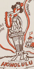 | Details | Mundorff, Ted | 1950 |
| Scarce pictorial map of Oahu, Hawaii |
|
Mundorff, Ted |
|
| 1950 |
| LOC:86 |
| $195.00 | Mundorff--Ted | Scarce-pictorial-map-of-Oahu--Hawaii | Scarce original pictorial map of Oahu, Hawaii by Ted Mundorff on light-ish weight paper. An insert road map from a book "Around Oahu with Moki: A trip around the Island of Oahu as seen through the versatile camera of Fred Maxwell." The map is annotated with location numbers keyed to Maxwell's book. Published by Maxwell from Honolulu in 1950.
<br><br>
Verso is blank.
<br><br>
Interesting cartoon-like drawings featuring cab driver Moki at bottom left lend a relaxed air to the prospective journey around Oahu including:
<div class="indenttextblocksingle">
<ul style="list-style-type: circle;">
<li>A hula-dancing rabbit on Rabbit Island.</li>
<li>Waialae Golf Club</li>
<li>A barber giving a shave at Barber's Point.</li>
<li>Healing stones</li>
<li>Manoa Valley</li>
<li>King Kamehameha</li>
<li>Schofield Barracks</li>
<li>Haleiwa and Kahuku</li>
</ul>
</div> |
| 6643 | 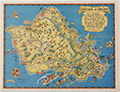 | Details | White, Ruth Taylor | 1931 |
| Pictorial map of the Island of Oahu in Hawaii |
|
White, Ruth Taylor |
|
| 1931 |
| LOC:89 |
| $200.00 | White--Ruth-Taylor | Pictorial-map-of-the-Island-of-Oahu-in-Hawaii | Fine lithographed cartograph or pictorial map of the island of Oahu, Hawaii by Ruth Taylor White. In 1931 White produced four maps of individual islands for the Hawaii Tourist Bureau: Kauai, Maui, Hawaii, Oahu, and one map of the entire Hawaiian Island chain. Printed by the Honolulu Star-Bulletin.
<br><br>
Locations and features that White captured on her map of Oahu include:"
<div class="indenttextblocksingle">
<ul style="list-style-type: circle;"></li>
<li>Waimea Falls</li>
<li>Kaneohe Bay</li>
<li>Kailua Bay</li>
<li>Diamond Head</li>
<li>Waikiki Beach</li>
<li>Honolulu</li>
<li>Pearl Harbor</li>
<li>Koko Head</li>
</ul>
</div> |
| 6644 | 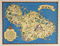 | Details | White, Ruth Taylor | 1931 |
| Pictorial map of the island of Maui in Hawaii |
|
White, Ruth Taylor |
|
| 1931 |
| LOC:89 |
| $250.00 | White--Ruth-Taylor | Pictorial-map-of-the-island-of-Maui-in-Hawaii | Fine lithographed cartograph or pictorial map of the island of Maui, Hawaii by Ruth Taylor White. In 1931 White produced four maps of individual islands for the Hawaii Tourist Bureau: Kauai, Maui, Hawaii, Oahu, and one map of the entire Hawaiian Island chain. Printed by the Honolulu Star-Bulletin.
<br><br>
Locations and activities that White featured on her map of Maui include:"
<div class="indenttextblocksingle">
<ul style="list-style-type: circle;"></li>
<li>Lahaina</li>
<li>Kaanapali</li>
<li>Kahului Harbor</li>
<li>Hana</li>
<li>Kipahuhu</li>
<li>Molokini</li>
<li>Makena</li>
<li>Wailuku</li>
</ul>
</div> |
| 6645 | 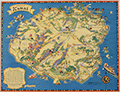 | Details | White, Ruth Taylor | 1931 |
| Pictorial map of the island of Kauai in Hawaii Polynesia |
|
White, Ruth Taylor |
|
| 1931 |
| LOC:89 |
| $250.00 | White--Ruth-Taylor | Pictorial-map-of-the-island-of-Kauai-in-Hawaii-Polynesia | Fine lithographed cartograph or pictorial map of the Polynesian island of Kauai, Hawaii by Ruth Taylor White. In 1931 White produced four maps of individual islands for the Hawaii Tourist Bureau: Kauai, Maui, Hawaii, Oahu, and one map of the entire Hawaiian Island chain. Printed by the Honolulu Star-Bulletin.
<br><br>
Locations and activities that White featured in her map of the Island of Kauai include:"
<div class="indenttextblocksingle">
<ul style="list-style-type: circle;"></li>
<li>Barking Sands</li>
<li>Napali Coast</li>
<li>Hanalei Beach</li>
<li>Moloaa</li>
<li>Nawiliwili Harbor</li>
<li>Port Allen</li>
<li>Ruins of Russian Port</li>
<li>Waimea</li>
</ul>
</div> |
| 6646 |  | Details | White, Ruth Taylor | 1931 |
| Pictorial map of the Island of Hawaii |
|
White, Ruth Taylor |
|
| 1931 |
| LOC:89 |
| $200.00 | White--Ruth-Taylor | Pictorial-map-of-the-Island-of-Hawaii | Fine lithographed cartograph or pictorial map of the island of Hawaii by Ruth Taylor White. In 1931 White produced four maps of individual islands for the Hawaii Tourist Bureau: Kauai, Maui, Hawaii, Oahu, and one map of the entire Hawaiian Island chain. Printed by the Honolulu Star-Bulletin.
<br><br>
Locations and features that White featured in her map of Hawaii include:"
<div class="indenttextblocksingle">
<ul style="list-style-type: circle;"></li>
<li>Mauna Kea</li>
<li>Mauna Loa</li>
<li>Kilauea</li>
<li>Hilo</li>
<li>Kealakekua Bay</li>
<li>Kailua</li>
<li>Upolu Point</li>
<li>Hookena</li>
<li>Hoopuloa</li>
</ul>
</div> |
| 6598 |  | Details | Dietemann, C.A. | 1934 |
| Scarce Pictorial Map Denver and Rio Grande Western Railroad |
|
Dietemann, C.A. |
|
| 1934 |
| LOC:400 |
| $250.00 | Dietemann--C-A- | Scarce-Pictorial-Map-Denver-and-Rio-Grande-Western-Railroad | C. A. Dietemann's scare pictorial map: Denver and Rio Grande Western (D&RGW) Railroad Scenic Line of the World spans four panels of a six-panel promotional brochure for the railroad featuring the Royal Gorge Route and the James Peak Route with the Moffat Tunnel, cutting through the Continental Divide. The map, dating from the mid 1930's features a wide expanse of the west including portions of New Mexico, Colorado, Utah and Arizona. From Salt Lake City to Denver, this fine map of routes for the Denver and Rio Grande Railroad entices the viewer to visit some of the West's greatest attractions including Mesa Verde National Park, Pikes Peak, Santa Fe, and Rocky Mountain National Park.
<br><br>
Dietemann's pictograms on this lithographed pictorial map feature numerous outdoor activities such as hiking, tennis, skiing, hunting, tobogganing, and fishing.
<br><br>
The D&RGW entered bankruptcy in 1935 and was not able to emerge from that status until 1947.
<br><br>
Only five holdings od Dietmann's pictorial map are found in WorldCat. No copies appear for sale on the market at this moment (01/23). |
| 6579 |  | Details | Deering, Roger L. | 1941 |
| Unrecorded pictorial map Portland Maine by Maine artist Roger Deering |
|
Deering, Roger L. |
|
| 1941 |
| LOC:3 |
| $575.00 | Deering--Roger-L- | Unrecorded-pictorial-map-Portland-Maine-by-Maine-artist-Roger-Deering | Unrecorded pictorial map of Portland, Maine copyrighted in 1941 by Maine artist Roger Deering.
<br><br>
Roger L. Deering (1904-1980) is best known for his paintings of Maine and is credited with creation of a series of small black and white prints for the Maine Bonding and Casualty Company of Portland, Maine.
<br><br>
Tri-fold brochure. Recto with text and black and white images explaining why the reader should "Make your headquarters in Portland". No reference found anywhere to "Playground Metropolis." |
| 6584 | 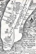 | Details | Held, John Jr. | 1931 |
| Pictorial Map of Lower Manhattan or Broadway Butterfly's Map |
|
Held, John Jr. |
|
| 1931 |
| LOC:89 |
| $200.00 | Held--John-Jr- | Pictorial-Map-of-Lower-Manhattan-or-Broadway-Butterfly-s-Map | John Held, Jr., (1889-1958) was a cartoonist, illustrator, printmaker and author. Held's cartoons satirized and epitomized the United States' “Jazz Age” of the 1920s. Here, Held's cartoon for "Broadway Butterflys" satirizes the fast life of the New York elite with its focus on Wall Street, Broadway, Fifth Avenue, and Park Avenue. Shows the Jefferson Market Night Court, now the Jefferson Market Branch of the New York Public Library and the morgue, "end of the Primrose Path." Presumably Held included the image to illustrate his story, “Broadway Butterfly,” in Held's second published collection of short stories, Dog Tales (1930).
<br><br>
Verso with an engraving by Held: "When the Theatre was Fraught with Romance."
<br><br>
Held was apparently a VERY popular cartoonist before the Depression. According to New York's Center Gallery: <div class="indenttextblocksingle">"He lived in the era of cartoonists as national heroes. In 1927, Vanity Fair named Held to its “Hall of Fame” alongside international luminaries of the decade. The Hearst newspapers paid him $250,000 a year (nearly $4,000,000 today, adjusted for inflation) for his cartoon strip, Oh! Margy, and his drawings sold for up to $5,000 each, roughly the price of a house." (1)
</div><br>
(1) Online. Retrieved December, 2022. https://www.centergallerynyc.org/exhibitions/johnheldjr |
| 6564 | 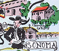 | Details | McCarty, Lea | 1955 |
| Scarce pictorial map of Sonoma County |
|
McCarty, Lea |
|
| 1955 |
| LOC:89 |
| $350.00 | McCarty--Lea | Scarce-pictorial-map-of-Sonoma-County | Fun, activity-oriented cartograph or pictorial map of Sonoma County, California by artist Lea McCarty. From a folding brochure "Fascinating Sonoma County in California's Redwood Empire Wonderland" issued in 1955 by the Sonoma County Board of Supervisors and Associated Chambers of Commerce of Sonoma Valley Inset context map withing a colorful compass rose shows Sonoma County in relationship to San Francisco and other nearby counties in California.
<br></br>
Coverage on this amusing map of Sonoma County includes portions of the surrounding counties: Napa County, Mendocino County and Marin County as well as numerous Sonoma County highlights to include:
<div class="indenttextblocksingle">
<ul style="list-style-type: circle;"></li>
<li>Bodega Bay</li>
<li>Bohemian Grove</li>
<li>Stewarts Point</li>
<li>Healdsburg</li>
<li>Digger Indian Reservation</li>
<li>Petrified Forest</li>
<li>Burbank Gardens, and</li>
<li>Petaluma</li>
</ul>
</div> |
| 6565 | 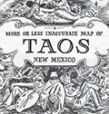 | Details | Lockwood, Ward | 1945 |
| Scarce pictorial map of Taos New Mexico by Ward Lockwood |
|
Lockwood, Ward |
|
| 1945 |
| LOC:89 |
| $325.00 | Lockwood--Ward | Scarce-pictorial-map-of-Taos-New-Mexico-by-Ward-Lockwood | Scarce mid-century pictorial map of Taos New Mexico by Ward Lockwood. This fine, humorous map of Taos comprises three panels in a folding brochure issued by the Taos Chamber of Commerce circa 1945.
<br></br>
<div class="indenttextblock">
<img src="/ZoomifyImages/SC_6565/SC_6565_Title.jpg" alt="Pictorial map of Taos New Mexico by Ward Lockwood, 1945" width="300" align="left" style="margin: 0px 20px">
</div>
<br></br>
Taos artist Ward Lockwood (1894-1963) attended the University of Kansas. Based in Taos (NM), Lockwood taught at the University of Texas (1938-49) and UC Berkeley (1949-61). |
| 6556 | 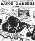 | Details | Anonymous | 1952 |
| Pictorial map New Orleans area near Bayou Gardens Lacombe Louisiana |
|
Anonymous |
|
| 1952 |
| LOC:3 |
| $150.00 | Anonymous | Pictorial-map-New-Orleans-area-near-Bayou-Gardens-Lacombe-Louisiana | Pictorial map (1952) of the New Orleans area to promote the Bayou Gardens attraction in Lacombe, Louisiana. The map spans the back two panels of a promotional brochure titled: "Bayou Gardens Lacombe, La. Beauty Spot of the Bayou Country."
<br><br>
Bayou Gardens was a 25-acre gardening attraction located north of New Orleans between Mandeville and Slidell. Bayou Gardens was founded in the late 1940's by convicted felon and former Louisiana Governor Richard W. Leche (1898-1965). In addition to a commercial nursery, swimming pool and a museum, according to the brochure "The Gardens contain one of the nation's outstanding Camelia collections, numbering hundreds of varieties."
<br><br>
Two-panel folding brochure with text on the recto. |
| 6551 | 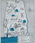 | Details | Johst, Paul Spener | 1931 |
| Johst pictorial maps of Alabama and Georgia |
|
Johst, Paul Spener |
|
| 1931 |
| LOC: |
| $135.00 | Johst--Paul-Spener | Johst-pictorial-maps-of-Alabama-and-Georgia | SOLD
<br><br>
Two pictorial maps of the states of Alabama and of Georgia in a pictorial cartoon-like style.
<br><br>
From "Picture Map Geography of the United States" by Vernon Quinn. With Picture Maps by Paul Spener Johst. Publisher: Frederick A. Stokes Company. New York. 1931. Some picture maps in the book contain depictions that today might be considered politically incorrect or even racist. |
| 6547 |  | Details | Gist, Gilman Jr. | 1943 |
| A Soldier's Guide to Palo Alto Pictorial WWII Era Map |
|
Gist, Gilman Jr. |
|
| 1943 |
| LOC:300 |
| $1,250.00 | Gist--Gilman-Jr- | A-Soldier-s-Guide-to-Palo-Alto-Pictorial-WWII-Era-Map | <br><br>
<div class="indenttextblocksingle">
"This cartoon guide makes it as easy as "Squads Right" to find that <b>place</b> you're looking for and right here within reach of all. If you want to splurge or just "gold-brick" away an evening this will show you just what you want and how to get there."
</div>
<br><br>
Rare pictorial map of Palo Alto, California by Gilman A. Gist Jr. (d. 1960) published in a 1943 issue of the Stanford Chaparral. The Stanford Chaparral or <i>Chappie</i> is a humor magazine published by students of Stanford University since 1899, the third oldest continually published humor magazine in the world.
<br><br>
Inset maps of Menlo Park, El Camino Real, and a stretch of Bayshore Highway. Includes light-hearted images of area restaurants, clubs, theaters and other businesses that a WWII G.I. might want to visit while on leave, as well as transportation. These fine establishments include:
<div class="indenttextblocksingle">
<ul style="list-style-type: circle;"></li>
<li>Bill and Walt Collins Club</li>
<li>Fat Boy Barbecue</li>
<li>O'Neil's Stanford Bowl</li>
<li>Dinah's Shack - real suthen chicken!</li>
<li>Varsity Theater</li>
<li>Stanford Theater</li>
<li>Clarence's Smoke Shop</li>
<li>Grab-a-bite</li>
</ul>
</div> |
| 6526 | 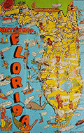 | Details | Skacel, Bill | 1946 |
| Pictorial Cartoon map of Florida Bill Skacel |
|
Skacel, Bill |
|
| 1946 |
| LOC:300 |
| $200.00 | Skacel--Bill | Pictorial-Cartoon-map-of-Florida-Bill-Skacel | Original, scarce pictorial map of the State of Florida by artist Bill Skacel ca. 1946. The humorous, historical cartoon map of Florida was produced ca. 1946 as a folded nine-panel tourist-oriented mailer with the verso containing space for an address as well as facts and photos of Florida
<br><br> |
| 6507 |  | Details | Skacel, Bill | 1946 |
| Pictorial Cartoon map of Vieux Carre New Orleans by Bill Skacel |
|
Skacel, Bill |
|
| 1946 |
| LOC:90 |
| $400.00 | Skacel--Bill | Pictorial-Cartoon-map-of-Vieux-Carre-New-Orleans-by-Bill-Skacel | Original, scarce pictorial map of the Vieux Carre or French Quarter in New Orleans, Louisiana by artist Bill Skacel ca. 1946. The humorous, historical "Cartoon Map of Vieux Carre in New Orleans" was produced ca. 1946 as a folded nine-panel tourist-oriented mailer with the verso containing space for an address as well as facts and photos of the New Orleans Vieux Carre.
<br><br>
Skacel takes a humorous angle at depicting Vieux Carre locations and culture in the post-WWII era. Two cartoon are puzzling- 1) four images of a young girl with pigtails wearing a sweatshirt bearing the letter "K" , that could possibly, represent a Catholic girl's school student or someone close to Skacel, and 2) at bottom right a matron crocheting a rug? with steel wire.
These cartoons include locations of:
<div class="indenttextblocksingle">
<ul style="list-style-type: circle;"></li>
<li>The Absinthe House, now the Old Absinthe House</li>
<li>Pirates Alley</li>
<li>Tabarry (Tabary) Theater</li>
<li>Napoleon House</li>
<li>A pelican</li>
<li>Blacksmith shop of Jean Lafitte</li>
<li>Cabildo prison</li>
</ul>
</div> |
| 6513 | 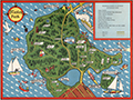 | Details | Page, Peter Hugh | 1940 |
| Fine second edition pictorial map of Stanley Park, Vancouver, British Columbia, Canada |
|
Page, Peter Hugh |
|
| 1940 |
| LOC:78 |
| $350.00 | Page--Peter-Hugh | Fine-second-edition-pictorial-map-of-Stanley-Park--Vancouver--British-Columbia--Canada | Beautiful lithographed pictorial map of Stanley Park, Vancouver, Canada by Peter Hugh Page, ca. 1940. Excellent condition. Second Edition. Shows Prospect Point, Brockton Point, Deadman's Island, Lost Lagoon, Second Beach, Beaver Lake and many other locations and attractions in Stanley Park.
<br><br>
<div align="center">
<a title="Stanley Park Cover"></a>
<img id="3" src="/ZoomifyImages/SC_6513/SC_6513_detail.jpg" alt="Cover from a brochure on Stanley Park, Vancouver, Canada by Peter Hugh Page in 1940." width="175"/> <br><small>Cover from Page's map of Stanley Park</small>
</div><br>
The second edition of Page's map of Stanley Park differs from the first edition in that it includes a depiction of the Lion's Gate Bridge (built 1939) and the label for Siwash Rock is removed. Verso with text about Stanley Park. |
| 6497 | 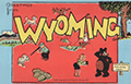 | Details | Skacel, Bill | 1946 |
| Pictorial Cartoon map of Wyoming |
|
Skacel, Bill |
|
| 1946 |
| LOC:90 |
| $250.00 | Skacel--Bill | Pictorial-Cartoon-map-of-Wyoming | Original, uncommon pictorial map of the State of Wyoming by artist Bill Skacel. The humorous, historical "Cartoon Map of Wyoming" was produced ca. 1946 as a folded nine-panel tourist-oriented mailer with the verso containing space for an address as well as facts and photos of the state of Wyoming.
<br><br>
Geographic coverage includes the towns of Jackson Hole, Cheyenne, Laramie, Kemmerer, Casper, and Cody as well as Yellowstone National Park.
<br><br>
Skacel's illustrations include moose, a horned dinosaur, Buffalo Bill, two devils, and a native-American maiden with teepee.
<br><br>
Copyright by E.C. Kropp Co. Milwaukee, Wis. C.M. 27. |
| 6465 | 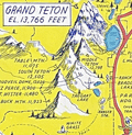 | Details | Lindgren, Jolly | 1948 |
| Pictorial map of the Jackson Hole country and Grand Teton National Park |
|
Lindgren, Jolly |
|
| 1948 |
| LOC:90 |
| $600.00 | Lindgren--Jolly | Pictorial-map-of-the-Jackson-Hole-country-and-Grand-Teton-National-Park | "A hysterical map of the Jackson Hole country and Grand Teton National Park slightly cockeyed" a fine pictorial map of the area around Jackson Hole, Wyoming. "Made on purpose" by artist Jolly Lindgren, Spokane, Washington.
<br><br>
In addition to numerous mountains identified by name and height Lindgren's many features include Jackson Lake, Jenny Lake, Jackson Hamburgers, Resor Ranch, Church of the Transfiguration, the Federal Elk Refuge, and numerous dude ranches identified by large western-style hats. |
| 6525 | 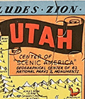 | Details | Lindgren, Jolly | 1948 |
| Pictorial hysterical puzzle map of Utah and parks |
|
Lindgren, Jolly |
|
| 1948 |
| LOC:300 |
| $175.00 | Lindgren--Jolly | Pictorial-hysterical-puzzle-map-of-Utah-and-parks | Unused pictorial puzzle map of the State of Utah- "A hysterical map of Utah which includes Zion, Bryce Canyon, Cedar Breaks & Stinking Springs". "Made in broken English" by artist Jolly Lindgren, Spokane, Washington. Includes the original puzzle mailer with a transparent front. Lindgren-Turner Company.
<br><br>
A humorous tourist-oriented puzzle featuring the State of Utah and many of its numerous natural attractions including:
<div class="indenttextblocksingle">
<ul style="list-style-type: circle;"></li>
<li>Dinosaur National Monument</li>
<li>Zion National Park</li>
<li>Bryce Canyon</li>
<li>Escalante Desert</li>
<li>Natural Bridge</li>
<li>Arches National Monument</li>
<li>Skull Valley</li>
<li>Canyon de Chelly, Arizona</li>
</ul>
</div> |
| 6437 |  | Details | Flachmann, Chuck | 1950 |
| Pictorial or cartoon map of St. Louis Missouri |
|
Flachmann, Chuck |
|
| 1950 |
| LOC:90 |
| $350.00 | Flachmann--Chuck | Pictorial-or-cartoon-map-of-St--Louis-Missouri | Pictorial map of St. Louis, Missouri. Specifically, the Anheuser-Busch variant edition of Chuck Flachman's Cartoon Map of St. Louis, 1950. Two prominent identifying features distinguish the Anheuser-Busch variant edition from Flachman's pictorial "Mound City Pride of the Mississippi Valley" edition: 1) The Busch Budweiser logo appears at bottom left rather than the compass rose and 2) the lettering surrounding the map reflects its Mound City moniker. Additionally, the Busch brewery and Clydesdale horses are featured on the map in the Busch edition. Both editions are dated 1950.
<br><br>
Scarce, the Busch-Budweiser variant is much less common on the market in our experience. |
| 6362 | 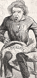 | Details | Stephen, Louis H. | 1862 |
| Civil War era satirical cartoon related to secession and loyalty |
|
Stephen, Louis H. |
|
| 1862 |
| LOC:1 |
| $50.00 | Stephen--Louis-H- | Civil-War-era-satirical-cartoon-related-to-secession-and-loyalty | Civil War era satirical cartoon related to secession and loyalty. Lampoons politically well-connected but inept John Floyd, considered to have been a traitor to the Union (1).
<br></br>
<br>
<div class="indenttextblocksingle">
<ul style="list-style-type: none;">
<div style="text-align: Left;font-size:125%;font-weight: bold;">An Old Friend, With a New Face
</div>
<br>
<br>
<li>Aesop tells of a man who drained.</li>
<li>His cup of avarice to the dregs;</li>
<li>Staked what he had to what he wished,</li>
<li>And lost his golden eggs.</li>
<br>
<li>Thus rashly acts the ambitious south,</li>
<li>In discontent without excuse;</li>
<li>Take warning and mind that ye </li>
<li>ARE SOUND UPON THE GOOSE.</li>
</ul>
</div>
<br></br>
(1) John Buchanan Floyd (1806 – 1863) 31st Governor of Virginia, U.S. Secretary of War, and Confederate general in the Civil War. Floyd lost the Battle of Fort Donelson. |
| 6428 | 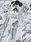 | Details | Anonymous | 1949 |
| Cartoon map of UC Berkeley engineering underground radiation nuclear laboratory |
|
Anonymous |
|
| 1949 |
| LOC:300 |
| $850.00 | Anonymous | Cartoon-map-of-UC-Berkeley-engineering-underground-radiation-nuclear-laboratory | Original centerspread 1949 cartoon pictorial map, "Underground Campus", the campus of the University of California Berkeley, specifically the engineering underground tunnels and facilities including the Radiation Lab. Scientists at the UC Radiation Laboratory, now the Lawrence Berkeley National Laboratory, discovered berkelium (atomic number 97) in 1949 using a 60-inch cyclotron.
<br></br>
<div id="3" align="center">
<a title="California Engineer smoking weed?"></a>
<img id="3" src="/ZoomifyImages/SC_6428/SC_6428_SmokingWhat.jpg" alt="Early depiction of a Berkeley Engineer with roach clip." width="240"/>
</div><br>
The California Engineer began in 1903 as the California Journal of Technology. It was the first college magazine in the west to specialize in the area of science and technology. In January, 1923, after a hiatus of ten years, the magazine was revived and renamed "California Engineer" by the Student Engineers Council (1).
<br></br>
The comical map is centered around Sather Tower with a cutaway view of the subterranean network below the halls at the University of California at Berkeley. Includes Sather tunnel, Leconte Hall, Gilman Hall, Wheeler Auditorium, The Radiation Laboratory housed the research at UC Berkeley during WWII under the Manhattan Project. Note the IBM punch card machine gag at bottom left.
<br></br>
The comical map is from the January 1949 issue of <b>California Engineer</b>, the annual "Mad Issue". 36 pages. Price when issued 25 cents. Published at the University of California, Berkeley, California by the Associated Students of the University of California. |
| 6450 |  | Details | Gluck, Jay | 1948 |
| Cartoon cutaway view of UC Berkeley dormitory life |
|
Gluck, Jay |
|
| 1948 |
| LOC:1 |
| $1,000.00 | Gluck--Jay | Cartoon-cutaway-view-of-UC-Berkeley-dormitory-life | With the premiere of the IMAX biopic "Oppenheimer" (1) less than one week away (7/18/2023) we offer "Oppy's Flop House", a rare and culturally insightful 1948 cartoon cutaway elevation view of a dormitory at the University of California at Berkeley, where Oppenheimer taught physics from 1929 to 1943.
<br><br>
<div id="0" align="center">
<a title=""></a>
<img id="6450" src="/ZoomifyImages/SC_6450/SC_6450_detail_1.jpg" alt=" Rare, culturally insightful 1948 cartoon cutaway elevation view of a dormitory at the University of California at Berkeley, where Oppenheimer taught physics from 1929 to 1943." width="300"/> <br><br> <font size="-2">Oppy's Flop House- Oppenheimer Caricature Detail</font>
</div><br>
Oppy's Flop House was published in the 1948 annual "Mad Engineer" issue of "California Engineer", a student publication of the University of California at Berkeley.
<br><br>
The title "Oppy's Flop House" refers to Robert Oppenheimer [2], one of the key researchers on the Atomic Bomb that had been dropped on Japan less than three years earlier. Cartoons and sight gags include a slide rule used as a fishing device and as a guitar, chem lab equipment used to brew coffee, students using radar to peer into the room of a bathing coed, a robot, a device based on compressed air to raise the skirts of coeds, and many scenes that include engineering book gags.
<br><br>
[1] https://www.oppenheimermovie.com/<br>
[2] Physicist <strong>Robert Oppenheimer</strong> (1904-1967) was Project Director for the <strong>Manhattan Project</strong>. Oppenheimer taught at UC Berkeley from 1929 - 1943. "With the rise of the Nazi party in Germany, the University quickly became a hub for atomic weapons development. By the outbreak of World War II, Oppenheimer, his students, and several notable physicists probed atomic theory on the top floor of Le Conte Hall." |
| 6340 |  | Details | Johnson, W.R. | 1955 |
| Plan of the Atomic Tunnel 1950's attraction near Daytona Beach |
|
Johnson, W.R. |
|
| 1955 |
| LOC:11 |
| $199.00 | Johnson--W-R- | Plan-of-the-Atomic-Tunnel-1950-s-attraction-near-Daytona-Beach | Lithographed plan / view of the <i>"World's Most Unusual</i> Atomic Tunnel". A four-panel <strong>Florida roadside-attraction</strong> brochure from the early 1950s. An atomic age wonder! The illustrator is unknown but his interpretation of Happy the Walking Fish is a high point in mid-century illustration with Happy dressed to the nines in bow tie, top hat, and tuxedo and carrying a cane.
<div class="indenttextblocksingle">
" … it was a long, white concrete building in the shape of a meandering tube, studded with 824 "port holes" (variously shaped small windows) that was designed primarily as a showcase and shop for exotic orchids. It also featured tropical birds, a monkey, and "Happy, the walking fish," a typical Southeast Asian "walking" catfish that could be prodded into flipping its way across a short dry connection from one tank to another." (1)
</div>
<BR />
<div id="1" align="center">
<a title="Atomic Tunnel">
<img id="TunnelPlan" src="/ZoomifyImages/SC_6340/SC_6340_Happy_400x300.jpg" alt="Atomic Tunnel" width="240"
/>
</a>
</div>
<div id="2" align="center">
<a title="Atomic Tunnel">
<img id="TunnelPlan" src="/ZoomifyImages/SC_6340/SC_6340_400x300.jpg" alt="Atomic Tunnel" width="300"
/>
</a>
</div>
<br />
<u>Verso</u> contains two reverse-profile portraits of "Happy, the Walking Fish" and also two fold-in panels showing a map and plan of the Atomic Tunnel with happy visitors strolling along walkways. The illustrator cleverly uses two different levels of scale on this work, at top a linear representation with mile boards of HWY 1 stretching from Daytona Beach, Florida through Port Orange to the Atomic Tunnel and below on the same page a plan view of the Atomic Tunnel's tunnels, rooms and walkways at a large scale. The <u>recto</u> shows detailed photographs of the rooms including the Fish room, Bird room and Cactus room. |
| 5434 |  | Details | Crabb, Earl and Shubb, Rick | 1970 |
| Counterculture Cartography Humbead's Revised Map of the World |
|
Crabb, Earl and Shubb, Rick |
|
| 1970 |
| LOC:87 |
| $285.00 | Crabb--Earl-and-Shubb--Rick | Counterculture-Cartography-Humbead-s-Revised-Map-of-the-World | Original 1970 third-edition offset-lithograph counter-culture map of the "world". The first edition of Humbead's Revised Map of the World was created in 1968 based on a concept by Earl Crabb and drawn by artist Rick Shubb. Two subsequent editions were released.
<br></br>
Copyright 1970 by The Great Humbead. |
| 5368 |  | Details | Money, Anton | 1943 |
| Rare cyanotype pictorial map Whitehorse, Yukon Territory, Canada |
|
Money, Anton |
|
| 1943 |
| LOC:55 |
| $1,250.00 | Money--Anton | Rare-cyanotype-pictorial-map-Whitehorse--Yukon-Territory--Canada | Very rare satirical, cyanotype pictorial view of the town of Whitehorse in the Yukon Territory of Canada dated within to October, 1943. A folk-art style humorous blueprint, bird's eye view of the city of Whitehorse by engineer Anton Money.
<br></br>
The view includes numerous annotated humorous scenes of daily life in Whitehorse including a Mountie dog-sled team, gold panning, gambling, drinking, whoring, the White Pass and Yukon Route narrow gauge railway and the Whitehorse railway station.
<br></br>
By explorer Anton Money with acknowledgements to Louis McCormick and Don Reikard.
<br></br>
No recorded sales or holdings of this view except for one copy at the library of the University of Calgary in Canada. |
| 5364 |  | Details | Anonymous | 1909 |
| Pair of manuscript allegorical Maps of the Heart, anatomically correct. |
|
Anonymous |
|
| 1909 |
| LOC:13 |
| $1,100.00 | Anonymous | Pair-of-manuscript-allegorical-Maps-of-the-Heart--anatomically-correct- | Two rare <b>manuscript pen and ink</b> anatomically-correct heart-shaped geographical guides or allegorical maps: "Map of Man's Heart" and "Map of Woman's Heart". Both maps are attributed within circular cartouches reading "Surveyed and Drawn by HUB. Scale 2 miles = 1". 1909." This style of anatomical heart-shaped maps and some of the traits are not found anywhere online.
<br></br>
After similar Victorian-era maps by D.W. Kellogg & Co. of Connecticut ca. 1840. Unlike this manuscript pair of maps, the Kellogg lithographs were based on a stylized and exaggerated bi-lobed conception of the heart- the "Valentine" heart that we know today. Despite the differences in wording of traits, the theme of negative stereotypes for women is the same.
<br></br>
Map of Man's Heart includes large areas devoted to patience, modesty, fidelity (twice), benevolence, humanity, knowledge and love. On the other hand, the Map of Woman's Heart largely features conceit, jealousy, scandal, duplicity, deceit, fickleness and avarice among other traits. The woman's heart is pierced by the "River Tongue" and surrounded on one side by the "kleptomaniac ocean" and on the other side, the "cantankerous ocean".
<br></br>
Seller attributes the provenance to India "it came from a nurses friendship book, she being based in Bangalore India - her name was probably MacDonald." |
| 5357 | 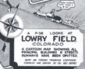 | Details | Grimes, George | 1944 |
| Pictorial map of Lowry Field Denver Colorado |
|
Grimes, George |
|
| 1944 |
| LOC:77 |
| $275.00 | Grimes--George | Pictorial-map-of-Lowry-Field-Denver-Colorado | A very scarce pictorial map of Lowry Field, at the eastern edge of Denver, Colorado, from the first issue of the Lowry Field Information Handbook [1] in November, 1944. Lowry field was activated in February, 1938 as the site of the Army Air Forces Training Command [2]. From the 1980’s, Lowry Air Force Base was one of Colorado’s largest employers. Lowry AFB employed nearly 10,000 military and civilian men and women, providing an economic impact annually approaching $1 billion [3].
<br></br>
<div class="indenttextblocksingle">
[1] Earliest publication was November, 1944 with a later edition of February, 1945. On the later map a telephone icon is added and locations of the telephone shelter house and telephone lounges are colored orange.<br>
[2] Information Handbook Lowry Field (AAF Training Command). Mountain States Telephone and Telegraph Company. Denver. 1944. Online.<br>
[3] https://wingsmuseum.org/about/history/. Online
</div> |
| 5343 |  | Details | Kidden, R. U. | 1956 |
| Humorous blueprint for a nuclear powered ship |
|
Kidden, R. U. |
|
| 1956 |
| LOC:55 |
| $600.00 | Kidden--R--U- | Humorous-blueprint-for-a-nuclear-powered-ship | One-of-a-kind, striking, original humorous cyanotype or blueprint diagram of a nuclear powered ship drawn in the era immediately after WWII when two hydrogen bombs helped end the war with Japan. In 1955, the United States commissioned the world's first nuclear powered vessel, the submarine U.S.S. Nautilus. The world's first nuclear-powered surface ship, the cruiser Long beach, was not commissioned into service until September, 1961.
<br></br>
Almost every feature on the ship has something wrong with it such that anyone familiar with ship design would find it amusing, yet the overall structure of the engineering drawing with the title block and sections for revisions and specifications, made the drawing seem plausible from a distance. Includes humorous mis-spellings and a crazy network of piping.
<br></br>
One of the key features is that many of the ship's features are labeled in Russian as well as English, reflecting the Cold-war competition between the two powers. Revision E3 explains "Added Russian translation applying to complete ship to save time when prints are stolen." Other funny bits include:
<br></br><div class="indenttextblocksingle">
<ul style="list-style-type: circle;">
<li>Outhouse on the stern is piped into the crew's forward supply tanks.</li>
<li>Floatplane on an upper deck has its floats mounted backwards.</li>
<li>Split-level crow's next is comprised of two stacked birdhouses.</li>
<li>Captains balls mounted on a upper guy wire (they belong on the compass)</li>
<li>Mid 19th-cenutury cannon part of the armament mounted on the bow.</li>
<li>The propeller is misshapen and dinged up.</li>
<li>The vessel is 100 feet long but 75 feet wide.</li>
<li>The plans are checked and approved by R. U. Kidden and I. M. Nuts.</li>
<li>Large pipe for radioactive waste flows into the crew's quarters.</li>
<li>Sickbay is shown stacked with caskets .</li>
</ul>
</div> |
| 5324 |  | Details | Anonymous | 1947 |
| Birdseye view of Johnston Island Atoll Pacific Ocean |
|
Anonymous |
|
| 1947 |
| LOC:300 |
| $295.00 | Anonymous | Birdseye-view-of-Johnston-Island-Atoll-Pacific-Ocean | One of a kind humorous birdseye view of the U. S. base at Johnston Island (also Johnston Atoll) in the Pacific Ocean. The author was clearly a member of the U. S. Armed Forces, probably Navy ("X.O.","yeomen", "chief"), who created this view as a memento or souvenir for others. Focus is one the off-hour entertainment and leisure activities on the island: Johnston Island Little Theater, Officer's Club, Ear Banger's Bar and Grill, J.I. Distillery, fishing, hobby shop, etc.
<br></br>
The date of this item is unclear but probably from the years immediately after WWII. Shows the troops engaged in construction activities. Quonset huts, four-engine propeller driven aircraft, and an airstrip apparently not paved and requiring watering to reduce the dust. No trace of heavy armament, or mention of the enemy, which would surely have been a major concern in the middle of the Pacific Ocean. The Navy operated Johnston Island from 1934 to 1948 when the Air Force took over. The site was used for high-altitude nuclear tests in the 1950s and 1960s.
<br></br>
Reproduced with a diazo process. |
| 5251 |  | Details | Hutson, H.H. | 1948 |
| Humorous map of the world from a Texans perspective |
|
Hutson, H.H. |
|
| 1948 |
| LOC:200 |
| $125.00 | Hutson--H-H- | Humorous-map-of-the-world-from-a-Texans-perspective | A humorous map of the world explained by pictorial illustrations related to Texas features and exaggerations. Distributed as a paper placemat for Long Champ restaurant in Amarillo, Texas - Homer Rice, Owner. Copyright 1948 by H.H. Hutson. Only one recent sale recorded, scarce. |
| 5172 | 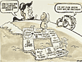 | Details | Campbell | 1983 |
| Original manuscript art for Reagan era Central America Game cartoon |
|
Campbell |
|
| 1983 |
| LOC:200 |
| $1,750.00 | Campbell | Original-manuscript-art-for-Reagan-era-Central-America-Game-cartoon | Rare original manuscript art by Campbell for Reagan era "Central America Game" cartoon, 1983. This one-of-a-kind satirical cartoon references decades of United States involvement in attempts to overthrow Central and South American governments (Cuba, Panama, Chile, Venezuela ), some successful.
<br></br>
Set surrounded by sea, spanning a globe, political leaders conduct a dialog above a gameboard emulating the landmass of Central America with Pinochet and Castro as board pieces. Ronald Reagan asks Henry Kissinger about the rules for meddling in the Americas. Dialog:
<div class="indenttextblocksingle">
<b>Ronald Reagan: </b>"How do you win this 'Central America' game Henry?"<br>
<b>Henry Kissinger: </b>"I'm not sure anyone ever has, Mr. President."
</div>
</br>
Pen and ink manuscript sketch with a few edits in white-out. Signed "Campbell Aug 11, 1983."
<br></br> |
| 5097 |  | Details | Withers, James Harlan | 1958 |
| A Texan's Map of U.S.A. |
|
Withers, James Harlan |
|
| 1958 |
| LOC:0 |
| $500.00 | Withers--James-Harlan | A-Texan-s-Map-of-U-S-A- | A Texan's Map of U.S.A. A derivative edition of a classic pictorial "humorous" map with more than a whiff of the intolerance that some believe permeates the state of Texas today. Tablecloth-sized map of the United States on Indian Head cloth [1] based on a design copyrighted by J.H. Withers in 1947 and branded with the imprint of Lackland Air Force Base in San Antonio, Texas.
<br></br>
Wither's distinctive design elements include a revised shape for Texas which extends to the west coast to provide Texas with a space for a "future seaport" and the appellation "damm' Yankee territory" for most of the northeast U.S.A.
<br></br>
The Catalog of Copyright Entries for 1947 records a copyright for "A Texan's Map of U.S.A.", held by James Harlan Withers of San Angelo, Texas. Wither's 1947 pictorial map is the earliest documented example of a genre of pictorial map with many derivative versions that begin with the fact that Texas was, at the time, the largest state in the U.S. and extend that simple premise to exaggerate the importance and quality of the state of Texas over the every other state in the U.S.A.
<br></br>
Early 50's date is supported by the fact that neither Alaska nor Hawaii, which both attained statehood in 1959, are mentioned on the map.
<br></br>
[1] Indian Head cloth was not manufactured after 1962. Indian Head Cloth Permanent Finish Sanforized stamping on a single line is associated with cloth produced from the late 1940s to early 1950s. (Source: http://info.fabrics.net/indian-head-remembered-revisiting-an-american-institution/) |
| 4984 |  | Details | West Coast Airlines | 1954 |
| Pictorial Map of Washington State by West Coast Airlines |
|
West Coast Airlines |
|
| 1954 |
| LOC:88 |
| $300.00 | West-Coast-Airlines | Pictorial-Map-of-Washington-State-by-West-Coast-Airlines | Scarce, colorful, pictorial map of airline routes across Washington, Oregon, and Idaho flown by West Coast Airlines. Statement at bottom of the map reads: "Paul Bunyan's Empire Cut to Travel Size".
<br></br>
West Coast Airlines (WCA), founded in 1941, was based at Boeing Field in Seattle. WCA began scheduled passenger service in 1946 with a fleet of Douglas DC-3s. Table at upper right contains a list of Key Points of Interest across the three-state area. Dated within at 1954. Verso with text and photo images from across the region.
<br></br>
Apparently the map was updated and re-issued again in 1962. |
| 4971 |  | Details | Withers, James Harlan | 1947 |
| Humorous map of Texas from a Texan perspective |
|
Withers, James Harlan |
|
| 1947 |
| LOC:63 |
| $700.00 | Withers--James-Harlan | Humorous-map-of-Texas-from-a-Texan-perspective | Scarce original blue-line, politically incorrect, map of the state of Texas from the 'humorously' distorted perspective of a Texan looking outward at the rest of the country. Believed to be the earliest recorded version of later similar 'humorous' maps of Texas inspired by Wither's design. Only one holding is found online, at the University of Texas, Arlington, where it is described:
<div class="indenttextblocksingle">
Map shows distortion of boundaries of the state of Texas in comparison to its U.S. neighbors with humorous bragging and derogatory relabeling. Relief shown by hachures. (Source: https://texashistory.unt.edu/ark:/67531/metapth252139/)
</div>
<br></br>
The Catalog of Copyright Entries for 1947 records a copyright for "A Texan's Map of U.S.A.", held by James Harlan Withers of San Angelo , Texas. Predates by two years the derivative but substantially different "A Texan's Map of the United States" by Frank Oliver published in 1949 for TexOak flooring.
<br></br>
The blue-line, or diazo process is a chemical method of document reproduction that fell out of use in the early 2000's. |
| 4801 |  | Details | Rathbun, Frank A. | 1890 |
| Early Cyanotype Advertisement for Rathbun's Wagon Jack and Wrenches |
|
Rathbun, Frank A. |
|
| 1890 |
| LOC:10 |
| $560.00 | Rathbun--Frank-A- | Early-Cyanotype-Advertisement-for-Rathbun-s-Wagon-Jack-and-Wrenches | A rare 19th-century <b>cyanotype print folk-art advertisement</b> ca. 1890 for F.A. Rathbun's wagon jack and wrenches. No other copy of any advertisement for Rathbun or his equipment is found online. The blueprint (cyanotype) photographic process, invented in 1842, was not adopted widely as a business document reproduction technology until after 1880.
<br></br>
With two cartoon-like drawings illustrating the "Worst Way" and the "Best Way" to change a wheel on a buggy or wagon (no mention of automobiles). The best way according to the author is Rathbun's Wagon Jack and Wrenches. Compliments of F.A. Rathbun Beloit, Wisconsin.
<br></br>
With an additional 3" x 7" cyanotype print of a large wrench labeled "F.A. Rathbun Beloit Wis."
<br></br>
The ad copy reads:
<div class="indenttextblock">
"Compliments of F.A. RATHBUN. BELOIT WIS. Manufactuer [sic] of his celebrated Wagon Jacks & Wrenches. By the use of which any one can grease thier [sic] wagon or buggy in less then one half the time required by the use of any other jack and wrench in the market without soiling hands or clothes. The pecular [sic] construction of the jack and manner in which it is used, recommmends its-self to all who know the trouble usually experienced with all jacks that have to be used under the buggy. This is the only jack that can be used at the end of the axle so that the wheel can be slid out on it for support. The 'wrench' also recommends itself to all who would avoid geting [sic] themselves greasy and dirty or straws and dirt on the nut to be scraped off or remain on to wear out the spindle. It is always ready. Never slips, and is quickly and easily operated. All who have used them recommed [sic] them to others. Liberal discount, to the trade and agents."
</div>
In April 1887 Frank A. Rathbun a machinist of Beloit Wis. assigned a patent he held on a wheeled scraper to F.W. Kimball of Milwaukee, Wis. However there is no mention of a patent on Rathbun's wagon jack. |
| 508 |  | Details | Cruikshank, George | 1835 |
| The Sailors Progress |
|
Cruikshank, George |
|
| 1835 |
| LOC:9 |
| $165.00 | Cruikshank--George | The-Sailors-Progress | Naval-themed frontispiece to a series of eight British naval caricature engravings by George Cruikshank depicting the life of Master Blockhead. Copperplate etching published by Thomas McLean, 26 Haymarket, London. August 1, 1835. Printed on an 11"x17" sheet of heavy wove paper the etching measure 5" by 7". |
| 473 |  | Details | Gillray, James | 1851 |
| End of the Irish Invasion |
|
Gillray, James |
|
| 1851 |
| LOC:9 |
| $195.00 | Gillray--James | End-of-the-Irish-Invasion | Re-strike satirical copperplate engraving from the original plate by one of England's finest 18th century artists and satirists, James Gillray. This engraving by James Gillray reflects the fear of invasion from France at the end of the 18th century, just a few years after the French revolution. The prospect of invasion by sea has threatened the British Isles several times beginning in Roman times, notably during the "Invincible Armada" sent by Spain in 1588. <BR> </BR>
The New York Public Library website explains the plate: <dir class="indenttextblock">"From the beginning of the conflict with France, the British feared a French invasion. In October 1796, the King warned against such a threat, which was dismissed by the Opposition as a fantasy. However, on December 15, 1796, a French force of 15,000 troops with an armada of ships, led by General Lazare Hoche, sailed from Brest and anchored in Bantry Bay off southern Ireland, assuming that their invasion would prompt a popular uprising against the British. Like the Spanish Armada two hundred years before, this plan was undone primarily by stormy weather. The winds in Gillray’s version emanate from (left to right) the mouths of Prime Minister Pitt, Secretary of War Henry Dundas, Foreign Secretary William Wyndham Grenville, and War Minister William Windham. One ship, Le Révolutionare with a Fox figurehead, is tossed by wind and waves, the L’Egalité is swamped, and the Whigs aboard The Revolutionary Jolly Boat appear doomed."</dir>
<BR>
Source: New York Public Library. Print Collection. No. 49.<BR> </BR>
Originally published in 1797 by Hannah Humphrey this plate is from the Henry Bohn restrikes printed from the original plates during 1845 to 1851. Printed on both sides of heavy wove paper, the other side contains another fine engraving by Gillray titled "The Lion's Share". |
| 474 |  | Details | Gillray, James | 1851 |
| The Hero of the Nile |
|
Gillray, James |
|
| 1851 |
| LOC:9 |
| $245.00 | Gillray--James | The-Hero-of-the-Nile | Re-strike caricature copperplate engraving from the original plate, by one of England's finest 18th century artists and satirists, James Gillray. Gillray's topic in this plate, first published in 1798, is one of Britain's naval heroes, Admiral Horatio Nelson (1758-1805). <BR> </BR>
Today, without an explanation many readers would not realize that this engraving is a caricature of Nelson, generally considered to be a great naval leader. The Greenwich Royal Museum explains Gillray's point of view:<i> " In contrast to other unquestioningly adulatory prints of Nelson’s victory at the Battle of the Nile, Gillray here sardonically points to the very large material rewards heaped upon Nelson as a result. Burlesquing the genre of heroic portraiture, he presents Nelson in solitary full-length, on deck and enveloped in smoke. Gillray draws attention to the diamond chelengk in Nelson’s hat, presented to him by the Sultan of Turkey, and in the adapted coat of arms below the main image satirizes his recent baronetcy. In November Nelson was created Baron Nelson of the Nile and Burnham Thorpe and was awarded a pension of £2000 a year. Gillray substitutes for the correct arms on the original shield a bulging purse and scroll inscribed ‘£2000 pr Ann’. Placed alongside Nelson’s motto ‘Palmam qui meruit ferat’ (Let he who has earned it bear the Palm), Gillray undermines the motto’s meaning, to question whether such a large material reward really is merited.</i><BR>
Source: National Maritime Museum, Greenwich, London. Collections.
<BR> </BR>
Originally published in 1798 this plate is a restrike by Henry Bohn printed from the original plates during 1845 to 1851. Printed on both sides of heavy wove paper, the other side contains another engraving, a biting satire by Gillray titled "Destruction of the French Collossus". Plate 211. |
| 475 |  | Details | Gillray, James | 1851 |
| St. George and the Dragon |
|
Gillray, James |
|
| 1851 |
| LOC:9 |
| $500.00 | Gillray--James | St--George-and-the-Dragon | Spectacular re-strike caricature copperplate engraving from the original plate, by one of England's finest 18th century artists and satirists, James Gillray. The quality of engraving and the dark impression, along with Gillray's composition, and large size make this a very striking and attractive work. <BR> </BR>
The scene depicts the royal St. George (King George III) rescuing Britannia from the fangs of the Monster of France (Napoleon). The king wears the uniform of his own regiment of Guards (the Blues). <BR>
Source: Wright, Thomas and Robert Harding. "Historical and Descriptive Account of the Caricatures of James Gillray" Google Books. P.242 <BR> </BR>
Originally published in 1805 this plate is a restrike by Henry Bohn printed from the original plates during 1845 to 1851. Printed on both sides of heavy wove paper, the other side contains another engraving, a satire by Gillray titled "The end of the farce of Catholic Emancipation". |
| 399 | 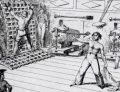 | Details | Barker, Matthew Henry | 1826 |
| Greenwich Hospital |
|
Barker, Matthew Henry |
|
| 1826 |
| LOC:0 |
| $400.00 | Barker--Matthew-Henry | Greenwich-Hospital | Collection of humorous nautical tales written by Matthew Barker and illustrated by George Cruikshank. Eleven etched plates and sixteen text woodcuts. Marbled boards. London: James Robins and Co., 1826 |