| | Thumbnail | | Creator | Date | Title / Author / Date / Location | Price | | | Description |
| 8041 | 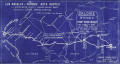 | Details | Hall, Dick Wick | 1920 |
| Rare Salome Road Map by Dick Wick Hall Los Angeles to Phoenix |
|
Hall, Dick Wick |
|
| 1920 |
| LOC:89 |
| $1,450.00 | Hall--Dick-Wick | Rare-Salome-Road-Map-by-Dick-Wick-Hall-Los-Angeles-to-Phoenix | Very rare unrecorded, hand-drawn road map, issued as a blueprint, of central Arizona and California, west of Phoenix by promoter, humorist, publisher, columnist and entrepreneur Dick Wick Hall. Inset note for aviation landing fields, rare on road maps of this era. Hall's initials D.W.H. at bottom right corner.
<br><br>
<div id="0" align="center">
<a title=""></a>
<img id="8041" src="/ZoomifyImages/SC_8041/SC_8041_Frog.jpg" alt="Dick Wick Hall's Famous Salome Frog." width="300"/> <br><br> <font size="-2">Hall's Famous Salome Frog<br> At the Laughing Gas Station. Salome AZ.</font>
</div><br>
Dick Wick Hall founded Salome, Arizona in 1904 as part of a speculative desert development venture along a proposed railroad route in western Arizona. He soon became the town’s most visible booster, operating a roadside service station, promoting travel through the desert, and cultivating a larger-than-life persona that blended entrepreneurship with humor.
<br><br>
Dated to 1920 based on a very similar map published by Hall in his Salome Sun mimeographed newspaper he published between 1920 and 1926. <div class="indenttextblock"><i>" ... the paper was likely intended to be supplied to service stations, such as the one Hall owned in Salome, or other road stops for the traveler passing through, as each issue contains short quips written by Hall about road trips, Yuma County, stories about the desert and driving in the southwest. The paper also often contains cartoonish illustrations of common southwest wildlife, from snakes to scorpions and cacti, as well as regularly featuring a cartoon frog by the name of the Salome Frog who regularly declares that he cannot swim."</i> </div> (Reference: State of Arizona Research Library. Online. https://azmemory.azlibrary.gov/nodes/view/328579).<br><br> |
| 8039 |  | Details | Mason, W.A. | 1887 |
| Unrecorded Manuscript Trace Cambridgeport Lands Frederick Lothrop Ames |
|
Mason, W.A. |
|
| 1887 |
| LOC:1401 |
| $2,750.00 | Mason--W-A- | Unrecorded-Manuscript-Trace-Cambridgeport-Lands-Frederick-Lothrop-Ames | A large, unrecorded pen and ink trace map on tracing cloth depicting lands on the Charles River Flats then held by the estate of Frederick Lothrop Ames (1) and associated owners, on the site now occupied by the Massachusetts Institute of Technology. The map was copied by William H. Whitney after Mason in the same month that the Massachusetts Legislature passed legislation that forced the cities of Cambridge and Boston to build the Harvard Bridge and share costs (2). Some portion of the map is attributed in pencil to a blueprint in Ames' possession, likely by W. A. Mason. Verso with the oval blue ink overstamp of William H. Whitney and index number 313.
<br><br>
The map was prepared in 1887, at a moment when the Charles River Embankment Company had begun construction of its granite seawall and was actively filling the Charles River Flats with dredged material from the river. It shows significant detail of the hydrography of the area including height in feet above low water at spring tide and the course of several small waterways including a detailed survey of Goff's Cove.
<br><br>Using the west line of the proposed Main Street extension, later realized as the Harvard Bridge, as a fixed boundary, and reading the notation on the mapped boundary, it appears Ames had already deeded lands west of this line to the Embankment Company. This drawing would have served as the working basis for negotiations over the remaining eastern portion of the Flats still under his ownership.
<br><br>
The sheet approximately covers the Charles River Flats from the navigable canal on the east to Goff's Cove on the west, and from the Boston and Albany Branch Railroad south to the planned 200 foot parkway along the riverbank. Detailed annotations at center record precise parcel boundaries totaling more than 2.3 million square feet and specify the fractional ownership interests of four parties, including Ames and the Charles River Embankment Company. Scale 80 feet to 1 inch.
<br><br> |
| 8037 | 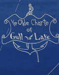 | Details | Conrad, Maynard | 1955 |
| Ye Olde Charte Of Gull Lake Kalamazoo County Michigan |
|
Conrad, Maynard |
|
| 1955 |
| LOC:130 |
| $375.00 | Conrad--Maynard | Ye-Olde-Charte-Of-Gull-Lake-Kalamazoo-County-Michigan | Mid twentieth century blueprint pictorial map of Gull Lake in Kalamazoo and Barry Counties, Michigan, with hand-drawn shorelines, compass rose, and whimsical period lettering. The sheet captures the resorts, parks, beaches, and cottages that once ringed this deep spring-fed lake north of Kalamazoo, documenting the area as a regional leisure destination. The artist, Dr. Maynard Conrad (d. 1998) uses simple white linework on blue background to present an engaging portrait of the lake at a time when summer colonies, canoe clubs, and motor launches were beginning to reshape the shoreline.
<br><br>
The map highlights a tight cluster of neighboring lakes that define the Gull Lake region. Little Long Lake and Miller's Lake appear to the northwest, while Grassy Lake is shown just beyond the isthmus that separates Gull Lake from its smaller companions. These lakes form part of a distinctive kettle-lake chain created by the region's glacial geography, a landscape that helped establish Gull Lake as one of the most celebrated inland waters of southwest Michigan. The sheet also notes well known features of the day, including Idlewild, Ross Township Park, Island Park, Crescent Beach, the Country Club grounds, and the string of cottages along Lover's Lane.
<br><br>
This pictorial blueprint serves equally as a regional souvenir and a record of community identity around Gull Lake. Resorts such as Bayberry Inn, Hickory Point, and Walnut Inn, together with family parks, bird sanctuaries, and boat landings, illustrate a thriving recreational culture. Surviving large format blueprints of local lakeside development are scarce, and this example offers collectors an attractive combination of graphic charm, local history, and early twentieth century Michigan cartographic style. |
| 8016 | 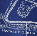 | Details | Bower, N. E. | 1902 |
| Map of the U.S. Military Reservation, Fort Sill, Oklahoma Territory |
|
Bower, N. E. |
|
| 1902 |
| LOC:130 |
| $2,400.00 | Bower--N--E- | Map-of-the-U-S--Military-Reservation--Fort-Sill--Oklahoma-Territory | Unrecorded and important 1902 blueprint map documents the entire U.S. Military Reservation at Fort Sill, Oklahoma Territory, just five years before Oklahoma statehood and one year after the last Indian lands in Oklahoma opened for settlement. Compiled and drawn under the supervision of 2nd Lt. N. E. Bower, Corps of Engineers, the map was prepared for a Board of Officers convened on November 6, 1902 to review and verify the reservation’s boundaries, fences, roads, streams, and terrain. It presents the reservation in three components -- the Original Reservation, the Western Addition, and the Eastern Addition -- with detailed Public Land Survey System grids, contour lines, drainage, and the developed cantonment near Medicine Bluff Creek.<br><br>With the frontier gone and the cavalry mission fading, the fort shifted toward a new role as artillery units arrived, including the formation of the 39th Field Artillery Battery in 1902. This transition ultimately saved the fort from closure, and with the last cavalry regiment departing in May 1907, Fort Sill was firmly on the path to becoming the home of U.S. Army Field Artillery.<br><br>This map captures that transition with precision, drawing on General Land Office surveys, U.S. Engineer triangulations, earlier post maps, and contemporary field notes. Today the blueprint stands as an important visual record of the boundaries and landscape of one of the nation’s most significant western military posts, known as the later home of the Field Artillery School and the final residence of the Apache prisoners of war, including Geronimo.<br><br> |
| 6848 | 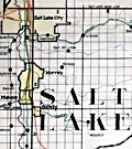 | Details | Utah Railway Chief Engineer | |
| Manuscript engineer's trace |
|
Utah Railway Chief Engineer |
|
|
| LOC:68 |
| $675.00 | Utah-Railway-Chief-Engineer | Manuscript-engineer-s-trace | Singular engineer's presentation trace for the Utah Railway. With this engineer's inked trace map the engineer's office could create numerous blueprint copies for distribution. Produced for the Utah Railway Chief Engineer's office and drawn by Elwood B. Stockman in Feb. 1927. Updated on June 1, 1934. Crisp artwork and lettering. Colors bright.
<br><br>
Shows Salt Lake City with the Salt Lake Base Line at upper left and extends well past Huntington, Utah at bottom right. Shows Park City.
<br><br>
The Utah Railway Company, originally named the Utah Coal Railway, was incorporated on January 24, 1912, and later shortened its name to Utah Railway in May of the same year. The company was founded to transport coal from its mines to Provo, Utah, due to an opening in the competitive landscape caused by dissatisfaction with the existing Denver and Rio Grande Railroad's service and route in the area.
<br><br>
During the 1930s, the Utah Railway faced challenges brought on by the Great Depression, which lowered demand for coal and, consequently, the railroad's business. However, the company managed to maintain its operations and even make some improvements during this difficult period. |
| 6769 | 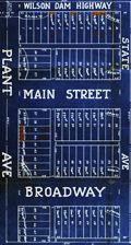 | Details | Milner, P. S. | 1925 |
| Blueprint map Industrial Plant Gate Addition Muscle Shoals Nitrate Plant 2 |
|
Milner, P. S. |
|
| 1925 |
| LOC:130 |
| $250.00 | Milner--P--S- | Blueprint-map-Industrial-Plant-Gate-Addition-Muscle-Shoals-Nitrate-Plant-2 | Scarce blueprint plat map for the Industrial Plant Gate Addition located near the main gate to the U.S. Government's Nitrate Plant #2 at Muscle Shoals, Alabama. Dated withing to April 27, 1925. The nitrate was used for producing gunpowder. An ugly reminder of the racism that was endemic one-hundred years ago is that one of the three building restrictions listed was "Caucasian Race Only."
<br><br>
Inset smaller-scale map of the greater Muscle Shoals district drawn by W. A. Dealy. The map shows the location of Nitrate Plants #1 and #2 in relationship to Sheffield, Florence, and Tuscumbia, AL.
<br><br>
Please see our other blueprint cadastral plat maps for the 1920's Muscle Shoals land boom from Keane Development Corp., Howell and Graves, and others. These proposed additions include Huston Heights, Lakeside Highlands, and Muscle Shoals Center. |
| 6522 |  | Details | Cockrell, Monroe F. | 1941 |
| Cyanotype 1st ed Military Campaigns of Nathan Bedford Forrest |
|
Cockrell, Monroe F. |
|
| 1941 |
| LOC:130 |
| $375.00 | Cockrell--Monroe-F- | Cyanotype-1st-ed-Military-Campaigns-of-Nathan-Bedford-Forrest | Cyanotype or blueprint map - "The Military Campaigns of Nathan Bedford Forrest" based on Forrest's cavalry campaigns in Tennessee, Alabama and Mississippi during the Civil War. The map was copyrighted in 1907 and published by Monroe F. Cockrell in 1941. Cockrell developed the map originally in 1907 when he was at V.M.I. based on information on N.B. Forrest from John Allen Wyeth's Life of Forrest (1900). Drawn by Emery L. Ring. September 18, 1941.
<br><br>
Rare. Only one copy of this map found online and this, the earliest known edition. A later 1944 printed edition is found online with citation at lower right to R.S. Henry's 1944 work "First with the Most - Forrest". The citation is lacking in this 1941 edition.[1]
<br><br>
Nathan Bedford Forrest (1821- 1877) was a <strong>Confederate cavalry commander </strong>during the U.S. Civil War. "His command was responsible for the massacre of African American Union troops stationed at Fort Pillow, Tennessee, in April 1864, and he served as the first grand wizard of the Ku Klux Klan in the early years of Reconstruction." [2]
<br><br>
A similar cyanotype map by Cockrell on Stonewall Jackson is also found online- " The Military Campaigns of Stonewall Jackson based on Henderson's Life of Jackson. June 1, 1940. [1]
<br><br>
[1] Tennessee Virtual Archive. Online: https://teva.contentdm.oclc.org <br>
[2] Glaze, Robert L. Nathan Bedford Forrest Confederate general. Britannica. Online: https://www.britannica.com/biography/Nathan-Bedford-Forrest |
| 6661 | 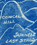 | Details | Henshell, J. | 1945 |
| Cyanotype pictorial map of Okinawa, Japan post WWII |
|
Henshell, J. |
|
| 1945 |
| LOC:86 |
| $350.00 | Henshell--J- | Cyanotype-pictorial-map-of-Okinawa--Japan-post-WWII | This is an original, rare cyanotype blueprint map, self published by J. Henshell, likely a soldier stationed on Okinawa, Japan. It depicts a birds-eye view of the Island of Okinawa, Japan and is dated November 1945, just three months after the surrender of Japan, or V-J Day (1). Henshell's design showcases his appreciation for local Okinawan art and culture, depicting shrines, temples, and tombs in a local artistic style. Local airfields and airbases are shown in rectangular boxes (e.g. Kadena, Futema, Yontan). After a Japanese Imperial Land Survey conducted in 1931.
<br><br>
The design also highlights the hills that played a significant role in the Battle of Okinawa. The island's rugged terrain made them difficult to attack. American forces faced fierce resistance from entrenched Japanese defenders during the battle. Henshell labels three of these key locations: Sugar Loaf Hill, the Conical Hill (Mount Yaedake), and the Japanese Last Stand.
<br><br>
Sugar Loaf Hill was a heavily fortified Japanese defensive position that played a significant role in the Battle of Okinawa. Today, it is a peaceful park and memorial site called the Okinawa Peace Memorial Park. The transformation of Sugar Loaf Hill from battlefield to symbol of peace is a testament to the strength of the people of Okinawa.
<br><br>
Mount Yaedake, also known as Conical Hill, was a key location in the Battle of Okinawa during World War II, as it was heavily fortified by Japanese defenders and provided a natural defensive position. Today, Mount Yaedake is a popular tourist destination, known for its stunning views of the surrounding area.
<br><br>
<div class="indenttextblock">
(1) Nakagusuku Bay, located on the eastern coast of Okinawa, was renamed Buckner Bay in honor of Lieutenant General Simon Bolivar Buckner Jr., who served as commanding General US Army's 10th Army Division during the Battle of Okinawa. Buckner was the highest-ranking US officer to be killed during the battle.
</div> |
| 6647 | 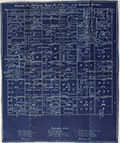 | Details | Douglas County Abstract Company | 1925 |
| Cadastral map Township No. 28 near Roseburg, Oregon |
|
Douglas County Abstract Company |
|
| 1925 |
| LOC:89 |
| $100.00 | Douglas-County-Abstract-Company | Cadastral-map-Township-No--28-near-Roseburg--Oregon | Blueprint cadastral map of lands southeast of Roseburg, Oregon. Date c. 1920's. |
| 6597 |  | Details | McClelland S.W. Kincaid R.L. et al | 1941 |
| Cyanotype (blueprint) map of the Route of Jefferson Davis in Spring 1865 |
|
McClelland S.W. Kincaid R.L. et al |
|
| 1941 |
| LOC:3 |
| $200.00 | McClelland-S-W--Kincaid-R-L--et-al | Cyanotype-(blueprint)-map-of-the-Route-of-Jefferson-Davis-in-Spring-1865 | Unrecorded and interesting cyanotype map of the route of Confederate General Jefferson Davis as he fled south after the Civil War from Charlotte, North Carolina to the city of Irwinville, Georgia where he hoped to escape to a foreign country. The map shows key rivers crossed and locations where Jefferson Davis stopped along the route.
<br><br>
Creators were Dr. S.W. McClelland, Dr. R.L. Kincaid, Dr. J.M. Nicholson, and C.P. Williams in August. 1941. This blueprint map is yet another scarce example of how an early photographic reproduction technology allowed individuals to disseminate their own unique works, bypassing traditional publishing technologies and institutions. |
| 6559 |  | Details | de Witt, Simeon | 1890 |
| Unusual manuscript trace map of New York state after Simeon de Witt 1802 |
|
de Witt, Simeon |
|
| 1890 |
| LOC:141 |
| $350.00 | de-Witt--Simeon | Unusual-manuscript-trace-map-of-New-York-state-after-Simeon-de-Witt-1802 | One of a kind finely detailed manuscript blue ink trace of sheet 6 from "A Map of State of New York" after Simeon de Witt, 1802. On tracing cloth. This map represents an exceptional effort that likely took days for the anonymous creator to lay down. With a few manuscript notes at bottom right that suggest the trace was created from the copy of de Witt's map held at the New York Public Library (1). Estimated date of creation ca. 1890.
<br><br>
A fine gift for collectors of New York cartography or of rare cartographic oddities.
<br><br>
From an estate with three similar manuscript traced maps of foundational New York State maps by David H. Burr, and <a href="https://www.rarecharts.com/ShowDetail/Creator/Hawkes--W--and-Barber--J-/Title/Manuscript-isodistance-map-of-the-New-York-City-area-after-Hawkes-and-Barber/6560" target="_blank">Hawkes and Barber. </a> Some hydrographic and marshy features in green ink, red ink for roads and highways, brown for political boundaries. Simeon de Witt's original map did not use color to identify these features. At bottom right, in manuscript, a copy of the original title cartouche that was not originally placed on sheet 6, demonstrating the tracer's access to multiple sheets of de Wits map.
<br><br>
(1) Lionel Pincus and Princess Firyal Map Division, The New York Public Library. "Map of the state of New York" The New York Public Library Digital Collections. 1802. https://digitalcollections.nypl.org/items/510d47df-f4d8-a3d9-e040-e00a18064a99 |
| 6560 |  | Details | Hawkes, W. and Barber, J. | 1890 |
| Manuscript isodistance map of the New York City area after Hawkes and Barber |
|
Hawkes, W. and Barber, J. |
|
| 1890 |
| LOC:141 |
| $700.00 | Hawkes--W--and-Barber--J- | Manuscript-isodistance-map-of-the-New-York-City-area-after-Hawkes-and-Barber | Very unusual and one-of-a-kind manuscript traced map ca. 1890 (on tracing cloth) of the area around New York City- after Hawkes and Barber's "The Country twenty five miles round New York" (1777). Text below the map contains a list of important events during the U.S. Revolution in 1776. A key feature of the map is the early use of <b>isodistances</b>, concentric circles at increasing five-mile intervals centered on the city of New York.
<br><br>
This map represents an exceptional effort that likely took days for the anonymous creator to trace. Fine attention to detail and careful execution suggest that the copy was created for research purposes, or possibly for the purpose of producing blueprints from this master trace document. With a few manuscript notes at bottom right that suggest the trace was created from the copy of Hawkes and Barber's map held at the New York Public Library (1).
<br><br>
A fine gift for collectors of New York cartography or of rare cartographic oddities.
<br><br>
From an estate with three similar manuscript trace maps of foundational New York State maps by <a href="https://www.rarecharts.com/ShowDetail/Creator/de-Witt--Simeon/Title/Unusual-manuscript-trace-map-of-New-York-state-after-Simeon-de-Witt-1802/6559"" target="_blank"> Simeon de Witt </a> and David H. Burr. Riverine features in green ink, red ink for highways and roads, brown for political boundaries and for isodistances.
<br><br>
(1) Lionel Pincus and Princess Firyal Map Division, The New York Public Library. "The Country twenty five miles round New York" The New York Public Library Digital Collections. 1777-01-01. https://digitalcollections.nypl.org/items/510d47da-ee36-a3d9-e040-e00a18064a99 |
| 6519 | 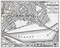 | Details | Fuller and Whitney | 1885 |
| Charles River Basin and Harvard Bridge Economic Studies |
|
Fuller and Whitney |
|
| 1885 |
| LOC:300 |
| $1,900.00 | Fuller-and-Whitney | Charles-River-Basin-and-Harvard-Bridge-Economic-Studies | Manuscript surveyors-trace economic option studies for road approaches and the proposed West Chester Park Bridge (now, Harvard Bridge, MIT Bridge, or Massachusetts Avenue Bridge). Eight surveyors' trace documents to support civil engineering and economic options for the placement of the Harvard Bridge, spanning the Charles River between Boston and Cambridge, Massachusetts. General plans for the new bridge were approved in July 1887; the bridge opened in September 1891.
<br><br>
The lot consists of eight MS pen and ink traces (for blueprint production) consisting of two base maps of Boston and Cambridge as well as six MS trace sheets with street and bridge options. The two base maps show the Charles River Basin with the existing West Boston Bridge (Longfellow Bridge) and road network. One map has much greater detail on street names and improved larger lettering.
<br><br>
Six map overlays:<br>
<div class="indenttextblocksingle">
<ul style="list-style-type: circle;">
<li>No 1. Shows the proposed new route as well as text and tabular information for the gain or loss of time over the proposed new route.</li>
<li>No. 2 Shaded area shows lands of the Charles River Embankment Company (proposed Esplanade),
proposed approaches to the Charles River Esplanade and proposed West Chester Park Bridge (aka Harvard Bridge)</li>
<li>No. 3 Approaches for the proposed West Chester Park Bridge (east of the final location)</li>
<li>No. 4 Second option. Bridge located at West Chester (aka Massachusetts Avenue) but terminated slightly more to the east.</li>
<li>No. 5 Third option. Bridge at West Chester, and a proposed wide avenue extending to the end of Commonwealth in Cambridge.</li>
<li>No. 6 Fourth option. No Esplanade </li>
</ul>
</div>
Scale 1650 feet to one inch. |
| 6429 | 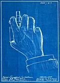 | Details | Holmes, Bradford Butterick | 1911 |
| Four cyanotype sketches for a concealed five shot revolver |
|
Holmes, Bradford Butterick |
|
| 1911 |
| LOC:300 |
| $380.00 | Holmes--Bradford-Butterick | Four-cyanotype-sketches-for-a-concealed-five-shot-revolver | Set of four original antique cyanotype or blueprint inventor's sketches for a concealable revolver. The revolver was designed by Bradford Butterick Holmes in 1911. In December, 1912 Holmes was granted US patent #1,047,054 on the revolver. It was Bradford Holmes' first patent, but not his last.
<br><br>
<div id="1" align="center">
<a title="Holmes' Revolver."></a>
<img id="1" src="/ZoomifyImages/SC_6429/SC_6429_400x300.jpg" alt="" width="250"/> <br><small>Fig. 1. Holmes concealed revolver</small>
</div><br>
The first sheet of four (Fig. 1.) shows an actual size depiction of the revolver concealed within the user's fist, only the short barrel extending beyond the fingers of a hand stretched from a cuff-linked shirt. Sheets 2, 3, and 4 are double size renderings of the revolver's mechanical details. The sketches are dated October 11, 1911 and witnessed by Ruth Vickery Holmes (Bradford's wife) and Hilma Christenson.
<br><br>
In 1903 Bradford Butterick Holmes is recorded as a first year student at the Massachusetts Institute of Technology with his home town listed as Mare Island, California. Apparently Bradford Holmes wed Ruth in May 1909 and together they had two children, Elizabeth and Robert.
<br><br>
Bradford Holmes was a prolific inventor. Between 1912 and 1952 Holmes was granted over 70 patents, some for Bendix Aviation, his presumed employer. In addition to the revolver Holmes' inventions include:
<div class="indenttextblocksingle">
<ul style="list-style-type: circle;"></li>
<li>Automatic steering device for dirigible craft (US1640896A) </li>
<li>Pressure breathing regulator (US2544991A) </li>
<li>Demand valve control mechanism (US2608971A)</li>
<li>Electric timing system (US2080273A) </li>
<li>Windshield wiper and fluid motor therefor (US1731048A)</li>
</ul>
</div>
Ruth Holmes is named as a co-inventor on eight of Bradford's patents, largely from the 1930's, related to a dirigible steering mechanism. |
| 6353 |  | Details | Coyle, J. E. F. | 1895 |
| Blueprint Sydney Northbridge Suspension Long Gully Bridge |
|
Coyle, J. E. F. |
|
| 1895 |
| LOC:300 |
| $1,500.00 | Coyle--J--E--F- | Blueprint-Sydney-Northbridge-Suspension-Long-Gully-Bridge | Beautiful, original late 19th century cyanotype (blueprint) profile view of the "North Sydney Bridge" NSW, then a suspension bridge, (also known as Northbridge or Long Gully Bridge). Original 48" rolled old blueprint paper with slight signs of wear consistent with date of late 19th century but fresh and bright from a protected environment. The rigid symmetry of the suspension bridge contrasts with the sketch-like character of the title and gully profile. Scale 20' = 1".
<br></br>
The Suspension Bridge in Northbridge, NSW was built as a steel suspension bridge with sandstone turreted towers by a private syndicate to promote residential development. The bridge opened to traffic in in January, 1892. With a suspension span of about 500 feet, it was considered one of the engineering wonders of Sydney and became a great tourist attraction. In 1939 the bridge was rebuilt as a reinforced concrete two rib arch bridge, with the original towers intact. (1)
<br></br>
Manuscript address on the verso "F. L. Keir Esq. Chief Engineer's. Railway Department. Brisbane. Queensland." Keir was an engineer with the railways department (2).<br /><br />
Sources:<br /> |
| 6326 |  | Details | Keane Development Corporation | 1933 |
| Blueprint plat map for Huston Heights Muscle Shoals, Alabama |
|
Keane Development Corporation |
|
| 1933 |
| LOC:53 |
| $250.00 | Keane-Development-Corporation | Blueprint-plat-map-for-Huston-Heights-Muscle-Shoals--Alabama | Rare unrecorded cyanotype (blueprint) plat map of the Huston Heights development near <b>Muscle Shoals</b>, Alabama which was incorporated in 1923.</b> Inset at upper left is a fine context map of the Tri-cities area of Florence, Sheffield, and Muscle Shoals compiled by T.J. Evans showing the locations of the Huston Heights development. Features the Wilson Dam on the Tennessee River and two nitrate plants. Dated within at February, 1933.
<br></br>
The plat encompasses an area in Muscles Shoals bounded by and including Ford Highway, Washington Drive, Henry Street and Sheridan Drive. |
| 5437 | 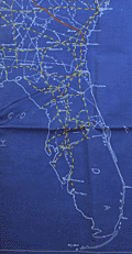 | Details | Durham Iron and Coal Company | 1911 |
| Unrecorded blueprint railroad freight map southeast United States |
|
Durham Iron and Coal Company |
|
| 1911 |
| LOC:1401 |
| $315.00 | Durham-Iron-and-Coal-Company | Unrecorded-blueprint-railroad-freight-map-southeast-United-States | Very large unrecorded cyanotype (blueprint) map, a decision maker's document, showing the railroad network and rates for freight on bituminous coal shipments across the southeastern USA. The map from 1911, by the Durham Iron and Coal Company, has been marked up in manuscript to show the rail lines for several railroad companies in six groups:
<div class="indenttextblocksingle"><ul style="list-style-type: circle;">
<li>Seaboard Airline Railway</li>
<li>Atlantic Coastline Railroad</li>
<li>Southern and M. O. </li>
<li>Louisville and Nashville; Nashville, Chattanooga and St. Louis Railroad; W and A </li>
<li>Queen and Crescent; A.G.S. N.O. N. E. </li>
<li>Illinois Central, Central of Georgia</li>
</ul>
</div> |
| 5430 | 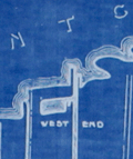 | Details | Anonymous | 1938 |
| Detailed map Railroads Interchanges, and Terminals New Orleans Louisiana |
|
Anonymous |
|
| 1938 |
| LOC:1401 |
| $900.00 | Anonymous | Detailed-map-Railroads-Interchanges--and-Terminals-New-Orleans-Louisiana | Original unrecorded blueprint (cyanotype) map of the railroad network in New Orleans in 1938. At a high level, the map shows the ownership and location of railroad tracks, interconnections (Interchanges) between railroad lines, and input/output points to the rail system (Terminals). Includes parts of the West Bank communities of Avondale, Westwego, Marrero, Harvey, Gretna, and Algiers. Also clearly shows the Industrial Canal (opened 1923) [1] and the New Orleans Lakefront Airport, then the Shushan Airport (opened 1934).
<br></br>
Shows the West End (remember Brunings? Fitzgerald's?) and the <strong> New Basin Canal</strong>, now long filled.
<br></br>
For many years New Orleans was a key seaport. Its location allowed access to large ships (cutting edge technology at that time) from across the world and provided a water route into the heart of the United States that favored movement of bulk goods and people.
<br></br>
At extreme upper left is a numerical index to key streets and locations in New Orleans (e.g. Julia Street, N.O. Cooperative Butchers Abattoir, and the Cotton Warehouse and Elevator). Below that is an index to the location of railroad interchanges and to support locations for railroad logistics operations: Engine Houses, Train Yards, Freight Depots, and Passenger Depots.
<br></br>
[1] More correctly known as the Inner Harbor Navigation Canal (IHNC). The IHNC connects the Mississippi River with Lake Ponchartrain. |
| 5422 |  | Details | Douglas, Jack | 1948 |
| Rare blueprint prospectors map of California gold lodes |
|
Douglas, Jack |
|
| 1948 |
| LOC:90 |
| $550.00 | Douglas--Jack | Rare-blueprint-prospectors-map-of-California-gold-lodes | Very rare cyanotype (blueprint) self-published gold mining map of California by Jack Douglas (d. 1956)- "The Old Prospector's Lode Map of California." At a scale of one inch = 32 miles the map shows areas in California known to have produced gold, shown as shaded areas.
<br></br>
The map includes crude decorative images of gold panning equipment and of an old prospector at work. At bottom left a list of other gold lode district maps for sale at $1.00 each includes Alaska, Arizona, British Columbia, Idaho, Montana, Nevada, New Mexico, Oregon, Utah, Washington, and Wyoming. These could be purchased along with blueprint assembly instructions for mining equipment by Jack Douglas at Box 21, Dutch Flat, California.
<br></br>
No holdings found in WorldCat and no mention of the map is found online.
<br></br>
Text at right discusses gold mining in several California mining districts. Verso is blank. Map no. 153.
<br></br>
Jack Douglas was the founder of the United Prospectors Organization (1947), originally targeted at professionals who made their livelihood by prospecting and mining. Douglas published a journal- Panning Gold- the first issue of which was issued in 1947. United Prospector's was incorporated on November 29, 1949 with Jack Douglas as President. Other officers at the time of incorporation included Walter Robertson, Stockton, CA; Tylar Jack, Reedy, CA; Speed Freeman, Olympia Field, IL; Louis Borde, Eugene, OR; Harold Mitchell, Umatilla, OR; and Glen Houston, Lodi, CA. Today UPI is "the oldest gold, gems, and minerals prospecting group of its kind."
<br></br>
<div>
<img src="/ZoomifyImages/SC_5422/Doodle_Bug.jpg" alt="" width="200" align="left" style="margin: 0px 10px"/>
<span style="vertical-align: middle;">
Note: Price includes an additional rare blueprint (shown here) for Jack Douglas' "Doodle Bug" wet concentrator. Copyright 1944.
</span>
</div>
<br></br> |
| 5373 |  | Details | Board of Park Commissioners San Francisco | 1938 |
| Blueprint plan of the San Francisco Aquatic Park |
|
Board of Park Commissioners San Francisco |
|
| 1938 |
| LOC:53 |
| $1,200.00 | Board-of-Park-Commissioners-San-Francisco | Blueprint-plan-of-the-San-Francisco-Aquatic-Park | Very rare design blueprint for the San Francisco Aquatic Park. The Park lies on the north west shore of San Francisco due south of the island of Alcatraz.
<br></br>
Original blueprint (cyanotype) plan of the San Francisco Aquatic Park ca. 1938 issued by the Board of Park Commissioners for San Francisco, California. The plan features the Bath Pavilion addition, built in 1939 by the Works Projects Administration (WPA).
<br></br>
Today the Aquatic Park Historic District is a National Historic Landmark- the San Francisco Maritime National Historic Park. The Bath Pavilion is home to the San Francisco Maritime Museum.
<br></br>
WPA project no. 2175. Sheet A-0. |
| 5368 |  | Details | Money, Anton | 1943 |
| Rare cyanotype pictorial map Whitehorse, Yukon Territory, Canada |
|
Money, Anton |
|
| 1943 |
| LOC:55 |
| $1,250.00 | Money--Anton | Rare-cyanotype-pictorial-map-Whitehorse--Yukon-Territory--Canada | Very rare satirical, cyanotype pictorial view of the town of Whitehorse in the Yukon Territory of Canada dated within to October, 1943. A folk-art style humorous blueprint, bird's eye view of the city of Whitehorse by engineer Anton Money.
<br></br>
The view includes numerous annotated humorous scenes of daily life in Whitehorse including a Mountie dog-sled team, gold panning, gambling, drinking, whoring, the White Pass and Yukon Route narrow gauge railway and the Whitehorse railway station.
<br></br>
By explorer Anton Money with acknowledgements to Louis McCormick and Don Reikard.
<br></br>
No recorded sales or holdings of this view except for one copy at the library of the University of Calgary in Canada. |
| 5345 | 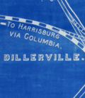 | Details | Snyder, Antes | 1896 |
| Antique blueprint map of Lancaster, Pennsylvania with railroads |
|
Snyder, Antes |
|
| 1896 |
| LOC:300 |
| $1,220.00 | Snyder--Antes | Antique-blueprint-map-of-Lancaster--Pennsylvania-with-railroads | Fine unrecorded 19th century cyanotype or blueprint map of Lancaster, Pennsylvania by the Pennsylvania Railroad Company . This original, large (34" x 24") blueprint from 1896 shows Lancaster, PA streets along with the route of the Philadelphia and Columbia Railroad passenger line and the Lancaster cut off freight line, both owned by the Pennsylvania Railroad Company. Additional key features include the Lancaster PRR station, the city limits, Big Conestoga Creek (Conestoga River), Dillersville, and two reservoirs.
<br></br>
The Pennsylvania Railroad (PRR) was established in 1846, with headquarters in Philadelphia, Pennsylvania. By 1882, the Pennsylvania Railroad had become the largest railroad by traffic and revenue, and the largest corporation in the world. Its budget was second only to the U.S. government.
<br></br>
Drawn under the direction of Antes Snyder, Right of Way Engineer, P.R.R. Blairsville, Indiana County, Pennsylvania. J. V. Kilgore, draftsman. 1896. Scale 400 feet = one inch. North is oriented to top. [Penn., railway] |
| 5343 |  | Details | Kidden, R. U. | 1956 |
| Humorous blueprint for a nuclear powered ship |
|
Kidden, R. U. |
|
| 1956 |
| LOC:55 |
| $600.00 | Kidden--R--U- | Humorous-blueprint-for-a-nuclear-powered-ship | One-of-a-kind, striking, original humorous cyanotype or blueprint diagram of a nuclear powered ship drawn in the era immediately after WWII when two hydrogen bombs helped end the war with Japan. In 1955, the United States commissioned the world's first nuclear powered vessel, the submarine U.S.S. Nautilus. The world's first nuclear-powered surface ship, the cruiser Long beach, was not commissioned into service until September, 1961.
<br></br>
Almost every feature on the ship has something wrong with it such that anyone familiar with ship design would find it amusing, yet the overall structure of the engineering drawing with the title block and sections for revisions and specifications, made the drawing seem plausible from a distance. Includes humorous mis-spellings and a crazy network of piping.
<br></br>
One of the key features is that many of the ship's features are labeled in Russian as well as English, reflecting the Cold-war competition between the two powers. Revision E3 explains "Added Russian translation applying to complete ship to save time when prints are stolen." Other funny bits include:
<br></br><div class="indenttextblocksingle">
<ul style="list-style-type: circle;">
<li>Outhouse on the stern is piped into the crew's forward supply tanks.</li>
<li>Floatplane on an upper deck has its floats mounted backwards.</li>
<li>Split-level crow's next is comprised of two stacked birdhouses.</li>
<li>Captains balls mounted on a upper guy wire (they belong on the compass)</li>
<li>Mid 19th-cenutury cannon part of the armament mounted on the bow.</li>
<li>The propeller is misshapen and dinged up.</li>
<li>The vessel is 100 feet long but 75 feet wide.</li>
<li>The plans are checked and approved by R. U. Kidden and I. M. Nuts.</li>
<li>Large pipe for radioactive waste flows into the crew's quarters.</li>
<li>Sickbay is shown stacked with caskets .</li>
</ul>
</div> |
| 5339 | 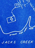 | Details | Somberg, Seymour I. | 1950 |
| Blueprint plat map of Cedar Grove Plantation St. Paul South Carolina |
|
Somberg, Seymour I. |
|
| 1950 |
| LOC:1401 |
| $900.00 | Somberg--Seymour-I- | Blueprint-plat-map-of-Cedar-Grove-Plantation-St--Paul-South-Carolina | Unrecorded blueprint or cyanotype plat map of <b>Cedar Grove Plantation</b> or Smythe Plantation, <b>St. Paul / Summerton, South Carolina</b> in Clarendon County with Robert Adger Smythe (1871-1962) , Manager. The blueprint was created ca. 1950 and signed by Seymour. I. Samberg L.S. (Land Surveyor) with property lines taken from an earlier plat by Bushner and Rutledge dated May 30, 1914. North oriented to lower left.
<br></br>
Robert Adger Smythe was born in Charleston, S.C. in 1871 and graduated from the Citadel in 1890. He founded the Lambda Chapter fraternity at the Citadel. Smythe spent most of his business years in cotton brokerage in Atlanta. Robert Smythe did not live at Cedar Grove, but visited often, conducting his business through manager Joe. H. King.
<br></br>
The earliest record of Cedar Grove Plantation dates to 1796 when Jack Lawson laid out a plantation of 2,160 acres between Jack's Creek and Taw-Caw. In the mid-1800's the plantation had grown to over 5,000 acres.
Nearby features on this plat map include Jack's Creek, Highway 15, Manning Turnpike, Lake Marion, Nelson's Ferry Road, and St. Paul.
<br></br>
Legend at bottom right includes the signature of Seymour Somberg. In 1953 Seymour I. Somberg was listed as President of Forestry Aids (forestry - surveying) in Manning, South Carolina. [1]
<br></br>
[1] Eller, Robert C. ed. Surveying and Mapping. Volume XIII, No. 1 January - March, 1953. p. 252. (Online) |
| 5333 | 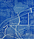 | Details | Howell and Graves | 1925 |
| Early blueprint plat map for Muscle Shoals, Alabama |
|
Howell and Graves |
|
| 1925 |
| LOC:53 |
| $275.00 | Howell-and-Graves | Early-blueprint-plat-map-for-Muscle-Shoals--Alabama | Rare blueprint map of Muscle Shoals Center Number Twelve Colbert County, Alabama. The map was part of a large development planned for the area.
<br><br>
Produced ca. 1925 by A. L. Howell and C. T. Graves Owners and Developers. Detroit, Michigan. Executive Office 350 Madison Avenue, New York, N. Y.
<br><br> |
| 6561 | 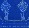 | Details | Howell and Graves | 1930 |
| Florence Alabama Lakeside Highlands Blueprint Plat Map Muscle Shoals |
|
Howell and Graves |
|
| 1930 |
| LOC:53 |
| $300.00 | Howell-and-Graves | Florence-Alabama-Lakeside-Highlands-Blueprint-Plat-Map-Muscle-Shoals | Rare original blueprint plat map of the Lakeside Highlands subdivision on the east side of Lake Wilson in the Muscle Shoals District at Florence in Lauderdale County, Alabama. With a small scale inset context map (1 inch = 1 mile): "Muscle Shoals District Showing Location of Lakeside Highlands." G.P. Nicolopoolos Owner and Developer. Date ca. 1930.
<br><br>
Drawn by W.A. Dealy, the map includes insets of a suggested tree-lined street section and a suggested business section designed by landscape architect Frank M. Button ("The highest type of Architecture is our aim.") Streets shown include the existing Lee Highway and Wilson Dam Highway (South Wilson Dam Road), and the proposed Center Drive, Shoals Boulevard, and Lakeside Drive, East Lakeside Drive and two bridle paths.
<br><br> |
| 5314 |  | Details | Ranson, Robert | 1906 |
| Antique map of Cracker Swamp drainage Hastings, Florida FEC |
|
Ranson, Robert |
|
| 1906 |
| LOC:87 |
| $800.00 | Ranson--Robert | Antique-map-of-Cracker-Swamp-drainage-Hastings--Florida-FEC | Cyanotype (blueprint) cadastral plat map of the vicinity around Hastings, Florida, the "Potato Capital of Florida", featuring a proposed drainage canal from the St. Johns River to Hawhead at the northernmost point of what is today referred to as "Cracker Swamp" . This early plat of the area in Volusia County, is from an auction lot of maps related to Wetumpka Fruit Company. The map was published in 1906 just 16 years after Hastings was founded by Thomas Hastings [1] at the urging of his cousin <b>Henry Morrison Flagler</b>. Hastings, northeast of East Palatka, Florida, in St. Johns County, had a population of about 1,200 in 1910.
<br></br>
With a graphed depth profile (at left) of the proposed canal running from the vicinity of May Road (Mays Cove Road) on the St. Johns River to Hawhead. Depth measurements are provided every 400 feet.
<br></br>
Shows the tracks of the Florida East Coast Railroad curving through Hastings, a portion of the <b>Huertas Grant</b> [2], East Palatka, and across Deep Creek. Other noted features include: Leonard Tract, White Towers, Buncombe Island (inside the "Cracker Swamp"), orange mills, Florida Vegetable Company Boulevard; and two short branches off Deep Creek- Wilkinson Branch and Cracker Branch.
<br></br>
[1] In 1889 Henry Flagler convinced his cousin Thomas H. Hastings to develop a farm nearby Flagler's railroad in order to supply vegetables to Flagler's St. Augustine resort hotels.<br>
[2] Spanish Governor Sebastien Kindelan granted St. Augustine, Florida resident Antonio Huertas 10,000 acres west of St. Augustine in 1813. |
| 5291 | 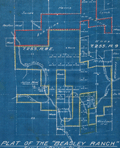 | Details | Parsons, A.F. | 1921 |
| Unrecorded cyanotype plat Beasley Ranch San Luis Obispo, California |
|
Parsons, A.F. |
|
| 1921 |
| LOC:3 |
| $475.00 | Parsons--A-F- | Unrecorded-cyanotype-plat-Beasley-Ranch-San-Luis-Obispo--California | Unrecorded cyanotype (blueprint) cadastral map of the Beasley Ranch in San Luis Obispo County, California. In 1921 the Beasley Ranch was owned by R.K. Smith. Manuscript outline coloring to differentiate the Beasley Ranch in yellow, from property owned by Eckstine in red.
<br></br>
The Beasley Ranch, at the junction of the Nacimiento River and Burnett Creek, was named for William F. Beasley, a native Californian from Mariposa County, CA. Neighboring property is recorded for Joshua Wood, Alice Lynch, Luther Hester, Sands, Harris, Wheeler, Knox, Eckstine, and others.
<br></br>
Survey of the Beasley Ranch was conducted by Austin F. Parsons in October, 1921. Parsons (b. 1853), was San Luis Obispo County Surveyor from 1902 to 1930. Parsons was the Civil Engineer for numerous area bridges including the California Canyon Bridge and San Juan Bridge.
<br></br>
Scale 1" = 40 chains ( 1/2 mile). T.25S R.8E. |
| 5268 | 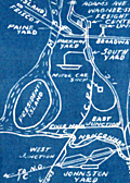 | Details | Anonymous | 1950 |
| Small Mid-20th Century blueprint map Memphis Railroad Terminal |
|
Anonymous |
|
| 1950 |
| LOC:13 |
| $135.00 | Anonymous | Small-Mid-20th-Century-blueprint-map-Memphis-Railroad-Terminal | Small unrecorded cyanotype (blueprint) map of Memphis, Tennessee related to the railway lines, rail yards, and railroad depots in the Memphis area. Would have provided a high-level condensed overview of the railways in the Memphis area.
<br></br>
Key features on the map include:
<div class="indenttextblocksingle">
<ul style="list-style-type: circle;">
<li>Union Station</li>
<li>Central Station</li>
<li>Paine Yard</li>
<li>Frisco Yale Yard</li>
<li>Forrest Yard</li>
<li>North Yard</li>
<li>South Yard</li>
<li>Johnston Yard</li>
<li>Motor Car shop</li>
<li>Mississippi River</li>
<li>President's Island</li>
</ul>
</div>
Dated within at May 1950. MS annotation on verso: "V. W. White." [Tenn. , TN] |
| 5227 | 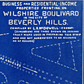 | Details | McDowell, L. N. | 1925 |
| Rare Cyanotype Cadastral Map Beverly Hills Wilshire Boulevard California |
|
McDowell, L. N. |
|
| 1925 |
| LOC:300 |
| $375.00 | McDowell--L--N- | Rare-Cyanotype-Cadastral-Map-Beverly-Hills-Wilshire-Boulevard-California | Rare, previously unknown and fascinating cyanotype strip map of Wilshire Boulevard in Beverly Hills, California ca. 1925 by L. N. McDowell. This 10.5 foot-long blueprint map stretches eastward from South Lasky Drive, past Rodeo Drive and Beverly Drive, and terminates to the west at San Vincente Blvd, a total linear distance of 2.25 miles. With numerous blue over-colored 'erasures', stamped bungalow pictograms, and MS notations (1940's and 1950's) documenting usage of the map well after 1926. (Note: Contact us for complete photographs.)
<br></br>
The map reflects the early history of Beverly Hills. It shows Preuss Road before renaming to Robertson Boulevard in 1926 (1) and Realtor Road before renaming to Arnaz Drive (2). El Camino Drive is recorded as "Speedway Drive" with "El Camino" in MS pencil. Between 1919 and 1924 the Beverly Hills Speedway occupied a tract of land at Wilshire and Beverly that now includes the Beverly Wilshire Hotel which was built in 1928.
<br></br>
Date is based on an LA Times article which fixes the date that Preuss Road was renamed as 'Robertson Road':
<div class="indenttextblocksingle">
"In 1926, the city of Los Angeles agreed to rename its section of Preuss Road as Robertson Boulevard to honor developer George Robertson. Beverly Hills also voted to rename its stretch of road after Robertson." (1)
</div></br>
Title: "Business and Residential Income Properties Fronting on Wilshire Boulivard [sic] in the City of Beverly Hills. Compiled by L.N. McDowell - 559087 -"
<br></br>
Scale 1" = 100'.
<br></br>
(1) https://www.latimes.com/archives/la-xpm-2006-dec-10-me-then10-story.html</br>
(2) ibid. Named not in honor of Desi Arnaz, but for Don Jose de Arnaz, a landholder in 19th century Los Angeles. |
| 5181 |  | Details | Krenn and Dato | 1924 |
| Krenn and Datos Dempster Street Evanston Chicago |
|
Krenn and Dato |
|
| 1924 |
| LOC:62 |
| $200.00 | Krenn-and-Dato | Krenn-and-Datos-Dempster-Street-Evanston-Chicago | Rare cyanotype, or blueprint, maps related to the lots for sale in the Dempster Street 'L' terminal addition, in northern Chicago, Illinois. Produced by Krenn and Dato, Subdividers. Interesting depictions of local commuter trains including the Elevated Extension or "L" and the Chicago and Northwestern Railroad.
<br></br>
Krenn and Dato are here self-described as "subdividers" operating from 600 N. Michigan Avenue, Chicago, Illinois. In a contemporaneous print for Edward A. Dato, the firm is listed as Krenn & Dato, Engineering, Consulting, and Service Company, Exclusive Agent for Mrs. Rockefeller's McCormick Properties.
<br></br>
Cyanotype engineering drawing is by G. I. Silander, Land Surveyor, Chicago. Dated within to 5-1924. Sheer 255. Evanston interest. |
| 5182 | 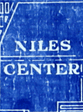 | Details | Goodson and Wilson | 1930 |
| Cyanotype blueprint map Evanston Illinois Niles Center Rogers Park |
|
Goodson and Wilson |
|
| 1930 |
| LOC:62 |
| $175.00 | Goodson-and-Wilson | Cyanotype-blueprint-map-Evanston-Illinois-Niles-Center-Rogers-Park | Original cyanotype or blueprint map including Evanston, Illinois with Niles Center, Rogers Park, and Edgewater neighborhoods ca. 1930. Includes a significant portion of Lake Michigan shoreline. Key noted features include West Moreland Golf Course, Northwestern University, Calvary Cemetery, Bryn Mar Golf Club, Edgewater Golf Club, and the Tam O'Shanter Country Club.
<br></br>
Blueprint shows usage to the master trace employed to create the print.
<br><br>
By Goodson and Wilson 35 W. Wacker Drive (the Jeweler's Building) , Chicago. Documentation online from 1931 shows a Goodson and Wilson Mortgage Company at 55 E. Wacker.
<br></br>
Thirty-five East Wacker Drive was originally designed and built in the 1920's as a high tech office tower for jewelers. The lower 23 floors were serviced by automobile elevators that transported the tenant, their jewels, and their car directly up to the office floor. |
| 5174 | 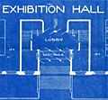 | Details | Hettinger, C. F. | 1901 |
| Cyanotype blueprint floor plan for 1901 Boston Brew-master's convention |
|
Hettinger, C. F. |
|
| 1901 |
| LOC:62 |
| $550.00 | Hettinger--C--F- | Cyanotype-blueprint-floor-plan-for-1901-Boston-Brew-master-s-convention | Original one-of-a-kind cyanotype, or blueprint, floor plan for the 1901 Brew-Master's Convention to be held in the Massachusetts Charitable Mechanic Association Building, Boston Mass. The 13th annual convention of the <b>United States Brewmaster's Association</b> was held in Boston during the week beginning on September 23, 1901.
<br></br>
The plan distinguishes between two areas in the building- the Convention Hall and the Exhibition Hall. The Exhibition Hall was a new feature of the convention:
<div class="indenttextblocksingle">
"… it has been thought desirable to make special arrangements for facilities for demonstrating and exhibiting all classes of machines and supplies adapted to brewer's use …" [1]
</div>
</br>
The Charitable Mechanics Association built the Mechanic's Hall in 1881 on Huntington Avenue, at West Newton Street near Copley Square. Architect William Gibbons Preston designed the hall which featured an auditorium, sometimes referred to as the Grand Hall. The hall was demolished in 1958.
<br></br>
Drawn and printed by C. F. Hettinger & Co. Engineers & Architects. 1140 Columbus Ave. Boston, Mass.
<br></br>
[1] Online: Gindele, William J. American Brewers' Review. Wahl and Henius eds. 1900-1901. p.282.
<br></br>
(beer, brewing, brew, craft beer, brewery, hops, tipsy, hopped up, loaded, drunk, shit-faced, sdfngd) |
| 5035 |  | Details | Georgia Southern and Florida Railway | 1916 |
| Track Chart Valdosta GA to Palatka FL for Georgia Southern and Florida Railway |
|
Georgia Southern and Florida Railway |
|
| 1916 |
| LOC:300 |
| $350.00 | Georgia-Southern-and-Florida-Railway | Track-Chart-Valdosta-GA-to-Palatka-FL-for-Georgia-Southern-and-Florida-Railway | Rare unrecorded cyanotype accordion-folded track chart or track profile (1916) for the <b>Georgia Southern and Florida Railway</b> over their Valdosta, Georgia to Palatka, Florida line. Measures more than 16 feet long. Railroad track charts are very rare and comprise an often-overlooked source for detailed geographic data that is unavailable elsewhere. Published January, 1916 with a MS note on the title page that the ballast is corrected to December 31, 1917.
<br></br>
The blueprint track chart was produced for internal use in the railway Engineering and Maintenance Office and thus may be the only copy remaining. Provides an unique source of detailed data for the railroad line which could be combined with existing cartographic data to enable father analysis.
<br></br>
Data includes railroad milepost numbers, track elevation, track grade, ballast composition (earth or cinders), track weight per linear yard, and geographical features. Notes features along the route including passenger stations, freight depots, water stations, coal stations, trestles, drains, culverts, and stock pens.
<br></br>
Please enquire for complete photographs of this 16' track chart. |
| 5012 |  | Details | Atlantic Coastline Railroad Company | 1939 |
| Lot of 2 very rare Atlantic Coastline Railroad Florida Track Charts |
|
Atlantic Coastline Railroad Company |
|
| 1939 |
| LOC:0 |
| $950.00 | Atlantic-Coastline-Railroad-Company | Lot-of-2-very-rare-Atlantic-Coastline-Railroad-Florida-Track-Charts | Lot of two rare condensed books of profile maps, or track charts providing unique, detailed data for a cross-section of Florida traversed by the Atlantic Coastline Railway. The two books were intended for use only within the railway system and include:
<div class="indenttextblocksingle">
<ul style="list-style-type: circle;">
<li>Northbound and southbound mainline of the Atlantic Coast Line Railroad Company between Richmond, Virginia and Jacksonville, Florida.</li>
<li>Track charts of A. C. L. R. R. feeder lines including Dunnellon to Wilcox, Trilby to St. Petersburg, Uceta to Tampa, and other routes.</li>
</ul>
</div>
By the Office of the Chief Engineer for the Atlantic Coast Line Railroad Company ca. 1938. Profiles are printed via the cyanotype process (blueprint). Numerous manuscript edits in red to maintain track profiles and routes current over time.
<br></br>
Provides a mile by mile detailed record of the path of the A.C.L.R.R. as it made its way south along the Atlantic Coast region and within Florida, for the routes noted above. Most of the data provided in these profiles are unavailable elsewhere and include:
<div class="indenttextblocksingle">
<ul style="list-style-type: circle;">
<li>Track weight per linear foot and year track was laid</li>
<li>Milepost number</li>
<li>Direction of the line via compass heading for sub-segments of the line</li>
<li>Slope of the grade for each sub-segment</li>
<li>Details about every opening beneath the railway including drainage pipes, bridges, arches, and boxes</li>
<li>County boundaries</li>
<li>Town and village names</li>
<li>Locations of railway infrastructure (freight depots, passenger stations, and signals) </li>
</ul>
</div>
Charts are paginated in booklet format. Charts are blank on verso. |
| 4979 | 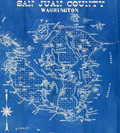 | Details | Washington Map and Blueprint Company | 1895 |
| Cyanotype map of San Juan County, Washington state |
|
Washington Map and Blueprint Company |
|
| 1895 |
| LOC:88 |
| $475.00 | Washington-Map-and-Blueprint-Company | Cyanotype-map-of-San-Juan-County--Washington-state | Early blueprint (cyanotype) map of the San Juan Islands including Stuart Island, Waldron Island, Orcas Island, Shaw Island, Blakely Island, Lopez Island, San Juan Island and many more. Numerous water features include the Canal de Haro, San Juan Channel, President Channel, Rosario Strait, Strait of Juan de Fuca, and Thatcher Passage. Manuscript notations in red for several parcels of land on Orcas Island and Lopez Island.
<br></br>
Scarce. With detached fragmentary front cover of map. Price when issued 50 cents.
<br></br>
By the Washington Map and Blueprint Company, 607-11 Pacific Block, Seattle, Washington. That company was the successor to the O.P. Anderson Map and Blueprint Company, Engineers and Draughtsmen. Established 1885.
<br></br>
Printed by Lowman and Hanford Stationery and Printing Company. |
| 4853 | 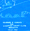 | Details | Hampton Yacht Club | 1941 |
| Hampton Yacht Club Regatta Cyanotype Map |
|
Hampton Yacht Club |
|
| 1941 |
| LOC:13 |
| $250.00 | Hampton-Yacht-Club | Hampton-Yacht-Club-Regatta-Cyanotype-Map | Unusual self-published cyanotype (blueprint) course map of the Hampton Yacht Club 14th Annual Regatta July 5 and 6 at Hampton, Virginia, complete with a sketch of an undulating sea serpent (rarely found on a cyanotype) and another small cartoon at the Hampton Bar. The course chart shows the coast outline with the offshore one-fathom line and the beacons and buoys marking the course.
<br></br>
This pre-war cartographic artifact is sold with two included documents:
<div class="indenttextblocksingle">
<ul style="list-style-type: circle;">
<li>A printed summary of the Regatta's sailing event with notes on prizes, courses, starting signals, rules for resolving protests, and a schedule of sailing events. For a map of the course the summary states: "See chart no. 400 and blueprint copies of part of the same which will be available at the clubhouse."</li>
<li> A one-page type-written set of Racing Rules for Warwick One Design Dinghies.</li>
</ul>
</div>Top left corner "H.K.S. 7/3/41" |
| 4826 | 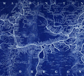 | Details | Union Pacific Railroad | 1933 |
| Map Oregon Washington Railroad and Navigation Company |
|
Union Pacific Railroad |
|
| 1933 |
| LOC:62 |
| $550.00 | Union-Pacific-Railroad | Map-Oregon-Washington-Railroad-and-Navigation-Company | Original cyanotype map (blueprint) of Oregon, Washington, and Idaho with the rail lines and stops of the Oregon-Washington Railroad and Navigation Company ca. 1933. Shows large and small railways some of which are now abandoned.
<br></br>
This map could be of interest for anyone with an interest in the Rails to Trails Conservancy or the Great American Rail-Trail initiative (a coast-to-coast multi-use trail of over 3,700 miles). Portions of this map includes abandoned tracks that are incorporated into that coast-to-coast trail including the Chicago, Milwaukee, St. Paul & Pacific Railroad (C. M. St. P and P.), now a part of the <b>Palouse to Cascades State Park Trail</b>.
<br></br>
Great detail and names of mountains in the Cascades Range including Mount Rainier, Mount St. Helens, Mount Adams, and Mount Hood. Coverage extends past Seattle to Everett, Washington.
<br></br>
The Oregon Railroad and Navigation Company operated from 1896 after a consolidation of several smaller railroads. Union Pacific (UP) purchased a majority stake of the line in 1898. In 1910 the line became a subsidiary of UP titled the <b>Oregon–Washington Railroad and Navigation Company.</b> Union Pacific formally absorbed the smaller railway into its system in 1936.
<br></br>
Dated 1933 based on 2 other similar items purchased in the same lot, each from the Chief Engineer's Office.
<br></br>
In the 1930's, minor abandonments of the company's Oregon lines included the partial abandonment of the line to Homestead, as well as joint operation with the Spokane, Portland & Seattle of the Oregon Trunk railroad line from the Columbia River south to Bend.
<br></br>
Drawn by REB. Published by the office of the Chief Engineer, Portland, Oregon. |
| 4820 |  | Details | Anonymous | 1926 |
| Rare Plan of the Carissa Gold Mine, South Pass, Wyoming |
|
Anonymous |
|
| 1926 |
| LOC:200 |
| $400.00 | Anonymous | Rare-Plan-of-the-Carissa-Gold-Mine--South-Pass--Wyoming | Rare cyanotype (blueprint) gold mine plan and section of the <b>Carissa Mine</b>, South Pass City, Wyoming.
<br></br>
During the late 1860s, miners discovered gold near South Pass City and the Carissa mine quickly became the most productive of all mines in the Sweetwater Mining District. After nearly 100 years, the Carissa Mine finally ended operations permanently in 1954.
<br></br>
Dated with reference to a similar, more detailed map of 1926 made during a detailed assay of the entire mine. (Hausel, W. Dan .The Carissa Gold Mine, South Pass Wyoming-A Sleeper. ICMJ. Prospecting and Mining Journal. July, 1999)
<br></br>
Three drawings are included: Longitudinal Section; Plan of the Third Fourth and Fifth Levels; and Claims Comprised in the Carissa Group.
</div>
Claims included the "Lucky Strike Placer", "Hermit Placer", "Chas. Dickens" and "Jeanette 183."
<br></br>
<a href="https://www.southpasscity.com/carissa-tours" target="_blank">South Pass City</a>
today is operated as a Wyoming state historic site with 40 historic buildings, one of the best-preserved gold mining towns in the American West:
<div class="indenttextblock">
"The State of Wyoming bought the 200-acre Carissa Mine site and began a ten-year restoration and reconstruction project. The interior was restored to the post–World War II period, when the mine and mill were most productive and milled approximately sixty tons of ore per day in three round-the-clock shifts. The reinstalled equipment is now fully functional. The State of Wyoming runs the Carissa Mine as part of the South Pass City State Historic Site, with tours of the mill that include demonstrations of the mid-twentieth-century milling equipment in operation."
<b>Samantha Ford, “Carissa Mine” [Lander, Wyoming], SAH Archipedia, eds. Gabrielle Esperdy and Karen Kingsley, Charlottesville: UVaP, 2012—, http://sah-archipedia.org/buildings/WY-01-013-0097.</b>
</div> |
| 4819 | 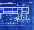 | Details | Market Street Railway Company | 1925 |
| San Francisco Streetcar Blueprint |
|
Market Street Railway Company |
|
| 1925 |
| LOC:62 |
| $375.00 | Market-Street-Railway-Company | San-Francisco-Streetcar-Blueprint | An original, authentic blueprint diagram from 1925 for a <b>Market Street Railway Company</b> "double-truck" (2 sets of wheels) streetcar. San Francisco, California. Scarce. The blueprint still carries the manuscript engineering index number, 907, in red crayon, that would have been used to uniquely identify the blueprint and to tie it to a set of specifications.
<br></br>
Title reads: "Market Street Railway Company. M.M. Department. Body Design & Seating Arrangement of Cars 266-285, 286-305, 779-808. Drawing number M.M. 3005. 8/24/25." Overall length including bumpers was 47'.
<br></br>
<figure>
<img src="/ZoomifyImages/SC_4819/Market_Street_Railway_Co_car_285.jpg" alt="Market Street Railway Company 47' streetcar number 285)" width="300" align="left" style="margin: 0px 20px">
<figcaption>
<div style="text-align:center;font-size: 80%">Streetcar number 285.</div>
</figcaption>
</figure>
<br></br>
The Market Street Railway Company began operating on July 4, 1860 with a steam railway. After a series of mergers and sales, the company was acquired by Standard Gas & Power Company in late 1925.
<br></br>
Source: Vielbaum, Hoffman, Ute, Townley. San Francisco's Market Street Railway. Charleston. Arcadia Pub. 2004. |
| 4818 | 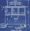 | Details | Market Street Railway Company | 1925 |
| Fillmore Hill "Dinky" Streetcar Blueprint |
|
Market Street Railway Company |
|
| 1925 |
| LOC:62 |
| $600.00 | Market-Street-Railway-Company | Fillmore-Hill-"Dinky"-Streetcar-Blueprint | Rare find! An original, authentic blueprint diagram from 1925 for a <b>Market Street Railway Company streetcar</b>. That is a San Francisco, Ca. streetcar, number 649!
<br></br>
The blueprint still carries the MS index number, 755, in red crayon, that would have been used to uniquely identify the blueprint and to tie it to a set of specifications. This type of streetcar was known to have a rough ride because unlike larger cars, "single-truck" streetcars had only one set of four wheels.
<br></br>
Rectangular purple ink stamp on verso for "Market Street Railway Company | Aug 29, 1925 | Blue Print Room". Number M.M. 3013.
<br></br>
Title reads: "Market Street Railway Company. M.M. Department. Body Dimensions of Fillmore Hill Cars after Reconstruction. Overall length 26' 3.5". <br> Overall Width 8' 0" ". 8/24/25.
<br></br>
<img src="/ZoomifyImages/SC_4818/MarketStreetCar621.jpg" alt="Market Street Railway Co. "Dinky" Fillmore Hill streetcar.")" width="300" align="left" style="margin: 0px 20px"> </img>
<br />
<br />
Some of the literature refers to this 26 foot long diminutively-sized street-car as a "Dinky". In its general dimensions and rolling equipment, our blueprint is very similar to car 578, built in 1896, one of the first generation of San Francisco's electric streetcars. Today, number 578 is stated to be the, "world’s oldest streetcar still on the active roster of an urban transit agency."
<br></br>
The Market Street Railway Company began on July 4, 1860 with a steam railway. After a series of mergers and sales, the company was acquired by Standard Gas & Power Company in late 1925.
<br></br>
Sources:
https://www.kalw.org/post/how-muni-s-oldest-streetcar-survived-122-years-become-san-francisco-s-sweetheart#stream/0
<BR/>
Vielbaum, Hoffman, Ute, Townley. San Francisco's Market Street Railway. Charleston. Arcadia Pub. 2004. |
| 4817 | 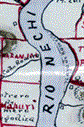 | Details | deHora, Manuel Herrera | 1913 |
| Antique Manuscript Gold-mining Map Antioquia Region in Colombia |
|
deHora, Manuel Herrera |
|
| 1913 |
| LOC:62 |
| $2,100.00 | deHora--Manuel-Herrera | Antique-Manuscript-Gold-mining-Map-Antioquia-Region-in-Colombia | Early <b>gold-mining map</b> in manuscript pen and ink on surveyor's tracing "cloth" by New York based mining engineer <b>Manuel Herrera de Hora</b> (1849-1934). Rare manuscript trace document of the gold field leases, including Oroville Dredging Company, near the Nechi River in Colombia, S.A. ca. 1913. For use in reproducing multiple blueprint (cyanotype) copies of the map.
<br></br>
<div class="indenttextblock">
"In my opinion, there is <b>no part of the world so favorable for investment</b> and so <b>attractive from the gold miner’s point of view</b> as the Department of Antioquia. [Colombia]"
<br></br>
"Dredgeman's paradise".
<br></br>
</div>
In his <a href="/ZoomifyImages/SC_4817/de Hora 2.pdf" target="_blank">presentation</a> to the American Institute of Mining Engineers in August 1913 de Hora made the business case for the profits that could be made using barge-mounted dredges to mine the thick gravel placer gold deposits along the Nechi, Cauca, and Porce Rivers near Zaragoza in Colombia's Antioquia department.
<br></br>
In his analysis de Hora reviews the history of gold-mining in the Antioquia region, describes topography and the physical properties of the region's gold, estimates risks and resource availability, and provides useful information on Colombia's liberal mining laws and climate. (de Hora, M.H. The Gold Placers of Antioquia, Republic of Colombia, South America. Bulletin American Institute of Mining Engineers. July 1913. p. 1197.)
<br></br>
The New York Times <a href="/ZoomifyImages/SC_4817/Manuel deHora.pdf" target="_blank">obituary</a> of de Hora in 1934 reads like chapters in an adventure novel:
<div class="indenttextblock">
<li>COLONEL DE HORA ADVENTURER, DIES</li>
<li>As Soldier of Fortune and a Mining Engineer Had a Thrilling Career.</li>
<li>Shanghied in his Youth</li>
<li>Reported to have Seized a Warship and Steamer--A Police Chief in South Africa</li>
</div> |
| 4801 |  | Details | Rathbun, Frank A. | 1890 |
| Early Cyanotype Advertisement for Rathbun's Wagon Jack and Wrenches |
|
Rathbun, Frank A. |
|
| 1890 |
| LOC:10 |
| $560.00 | Rathbun--Frank-A- | Early-Cyanotype-Advertisement-for-Rathbun-s-Wagon-Jack-and-Wrenches | A rare 19th-century <b>cyanotype print folk-art advertisement</b> ca. 1890 for F.A. Rathbun's wagon jack and wrenches. No other copy of any advertisement for Rathbun or his equipment is found online. The blueprint (cyanotype) photographic process, invented in 1842, was not adopted widely as a business document reproduction technology until after 1880.
<br></br>
With two cartoon-like drawings illustrating the "Worst Way" and the "Best Way" to change a wheel on a buggy or wagon (no mention of automobiles). The best way according to the author is Rathbun's Wagon Jack and Wrenches. Compliments of F.A. Rathbun Beloit, Wisconsin.
<br></br>
With an additional 3" x 7" cyanotype print of a large wrench labeled "F.A. Rathbun Beloit Wis."
<br></br>
The ad copy reads:
<div class="indenttextblock">
"Compliments of F.A. RATHBUN. BELOIT WIS. Manufactuer [sic] of his celebrated Wagon Jacks & Wrenches. By the use of which any one can grease thier [sic] wagon or buggy in less then one half the time required by the use of any other jack and wrench in the market without soiling hands or clothes. The pecular [sic] construction of the jack and manner in which it is used, recommmends its-self to all who know the trouble usually experienced with all jacks that have to be used under the buggy. This is the only jack that can be used at the end of the axle so that the wheel can be slid out on it for support. The 'wrench' also recommends itself to all who would avoid geting [sic] themselves greasy and dirty or straws and dirt on the nut to be scraped off or remain on to wear out the spindle. It is always ready. Never slips, and is quickly and easily operated. All who have used them recommed [sic] them to others. Liberal discount, to the trade and agents."
</div>
In April 1887 Frank A. Rathbun a machinist of Beloit Wis. assigned a patent he held on a wheeled scraper to F.W. Kimball of Milwaukee, Wis. However there is no mention of a patent on Rathbun's wagon jack. |
| 4747 | 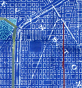 | Details | Edward E. Manning Company | 1925 |
| Cyanotype map of north Chicago and Evanston, IL |
|
Edward E. Manning Company |
|
| 1925 |
| LOC:62 |
| $320.00 | Edward-E--Manning-Company | Cyanotype-map-of-north-Chicago-and-Evanston--IL | Authentic hand-colored cyanotype (blueprint) Chicago-area map from ca. 1925. A fine, unique early 20th-century artifact that should appeal to collectors or others with interests in Evanston or Chicago, Illinois and its expansion into the suburbs. Cyanotype maps are generally scarce.
<br></br>
Coverage begins at W. Lawrence Avenue and extends north to Lake Avenue in Evanston, Illinois. Our map is bounded to the east by Lake Michigan and to the west a few blocks past Harlem Avenue. Shows the location of Northwestern University along Lake Michigan. Includes by name Morton Center, Edison Park, Rogers Park, and the town of "Niles Center", now Skokie, Il.
<br></br>
In the 19th century blueprints (cyanotype prints) were generally scarce as blueprinting had only been invented in the 1870's. By 1899 the cyanotype process was beginning to become widely adopted as a quick method of reproducing maps, plans, and architectural diagrams. Blueprinting was a well-accepted business tool in 1925.
<br></br>
Produced by the Edward E. Manning Company, 55 W. Wacker, Drive, Chicago. |
| 4735 |  | Details | Lake Shore Realty Co. | 1925 |
| Cyanotype Sales Map of Howard Avenue Subdivision No. 2 Chicago |
|
Lake Shore Realty Co. |
|
| 1925 |
| LOC:88 |
| $350.00 | Lake-Shore-Realty-Co- | Cyanotype-Sales-Map-of-Howard-Avenue-Subdivision-No--2-Chicago | Authentic cyanotype (blueprint) Chicago-area map from 1925 with interesting illustrations of local transportation including an electrified trolley and coal-fired steam locomotive. A fine, unique early 20th century artifact that should appeal to advertising collectors or others with interests in Evanston or Chicago, Illinois and the expansion into the suburbs. Dated within to 5/28/25. Drawn by J.R.W.A.
<br></br>
Right-hand side of this neat piece shows a large scale map with major streets centered on the Howard Ave Subdivision No 2. Concentric circles drawn at one mile intervals for 3 miles total radius. Left hand large-scale map of the Subdivision with side streets Jonquil Terrace, Lehigh Ave., Dobson Street, and North Meade Ave. Lots already sold are highlighted with dark red pencil.
<br></br>
The new subdivision was located at the intersection of Gross-Point Road and Howard Ave (now Street). Also crossing that intersection is a proposed trolley car line on Howard Ave. and the Chicago, Milwaukee and St. Paul R.R. with a locomotive drawn heading northbound pulling a freight car and four passenger cars.
<br></br>
Text describes restrictions, title guarantor, and contact details for the Lake Shore Realty Co. at Consumer's Building Room 1716. 220 State Street. Phone Wabash9180.
<br></br>
Restrictions were: " Howard Ave is restricted to business buildings of stone or brick construction, two or more stories high. Balance is restricted to residence or apartment buildings of stone or brick construction." Titles guaranteed by Chicago Title & Trust Co.
<br></br>
In the 19th century blueprints (cyanotype prints) were generally scarce as blueprinting had only been invented in the 1870's and by 1899 the process was beginning to become widely adopted as a quick method of reproducing maps, plans, and architectural diagrams. Blueprinting was a well-accepted business tool in 1925 but no other copy of this map is found online. |
| 3693 | 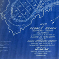 | Details | Hunter, T.B. | 1909 |
| Large antique blueprinted map of Pebble Beach, California |
|
Hunter, T.B. |
|
| 1909 |
| LOC:1408 |
| $1,800.00 | Hunter--T-B- | Large-antique-blueprinted-map-of-Pebble-Beach--California | Fine large rolled 5' original antique cyanotype (blueprint) map (20 sq. ft.) of Pebble Beach, CA made in 1909, almost ten years before the opening of the famed Pebble Beach golf course. The earliest reasonably obtainable and the largest cyanotype cadastral map of Pebble Beach, CA.
<br></br>
Ironically, on this map the area now partly occupied by the golf course is marked "Reserved for Public Use". Pebble Beach Lodge is shown centered within Lot 123, a parcel of 9.487 acres. Locations that are shown but not named include Arrowhead Point, Pescadero Canyon, and Stillwater Cove.
<br></br>
Data for each lot include the lot number, metes and bounds (bearing and length of all lines bisecting each physical property marker stake), and acreage.
<br></br>
Includes Seventeen-Mile Drive and Carmel Bay. Monterey County. Shows topography with contour intervals of 10 feet.
<br></br>
Surveyed by T.B. Hunter, C.E. and drawn by T.F. Rogers.
<br></br>
North is oriented to upper right.
<br></br>
(Note: Yellow straight-edge rules shown are 48" long.) |
| 3613 |  | Details | Multiple Authors | 1885 |
| Lot 2. MULTIPLE antique surveyors plans BACK BAY, BOSTON , Massachusetts |
|
Multiple Authors |
|
| 1885 |
| LOC:0 |
| $6,200.00 | Multiple-Authors | Lot-2---MULTIPLE-antique-surveyors-plans-BACK-BAY--BOSTON---Massachusetts | A lot consisting of twenty lot and street plans from Boston, Massachusetts generally from the decade of the 1880's. Most items by surveyors and engineers William H. Whitney or the firm of Fuller and Whitney, Back Bay Engineers. An opportunity for a serious collector of Boston cartography to expand his collection with items he cannot find except in institutions. <a href="https://www.rarecharts.com/Content/Lot_2_Boston_Survey_Artifacts_Locked.pdf" target="_blank">See full detailed lot description.</a>
<br></br>
From the mid 1850’s through 1890 Boston conducted the most ambitious land-making of the era in the U.S. by transporting and placing gravel, ashes, and sand in an area that was previously a tidal marsh of the Charles River. The landfill of Boston’s Back Bay was fueled by a shortage of suitable land for new construction and the desire to remediate water pollution resulting from earlier bad decisions that placed profit ahead of citizen’s health and welfare.
<br></br>
Over a period of 35 years more than 450 acres of new land was added to Boston by filling the Back Bay with an average of 20 feet of fill. Much of this land was purchased by well-to-do Bostonians and today the Back Bay remains one of the most prestigious locations within that city.
<br></br>
We have been able to obtain 20 rare late 19th century artifacts that document the last decade of the 35 year land-making project in Boston’s Back Bay, for an area from Charlesgate Park to past Kenmore Square.
<br></br>
These maps and plans shed light on some of the decision-making factors and design options for Boston real-estate developers. These artifacts in this lot are of three types: hand-drawn or manuscript survey maps, manuscript traces of those surveys, and blueprints. The artifacts represent a very early application and adaptation of a cutting-edge technology: blueprinting. |
| 3597 | 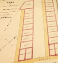 | Details | Multiple Authors | 1870 |
| Lot 1. MULTIPLE 19th C. survey lot and street plans CAMBRIDGE, Massachusetts |
|
Multiple Authors |
|
| 1870 |
| LOC:0 |
| $14,650.00 | Multiple-Authors | Lot-1---MULTIPLE-19th-C--survey-lot-and-street-plans-CAMBRIDGE--Massachusetts | A lot consisting of twenty-five lot and street plans from Cambridge, Massachusetts and nearby areas. An opportunity for a serious collector to expand his collection with items he cannot find elsewhere. <a href="https://www.rarecharts.com/Content/Lot_1_Cambridge_Survey_Artifacts_Locked.pdf" target="_blank">See full detailed lot description.</a>
<br></br>
These plans represent surveys performed in the 1840’s through the 1900’s by local Cambridge area surveyors and engineers William A. Mason, Joseph Whitney, J.G. Chase, E.F. Bowker, W.S. Barbour, and Alex Wadsworth. Artifacts include manuscript surveys, manuscript survey traces, and rare 19th century cyanotype (blueprints). Many of the items in this lot are unrecorded and for the others the few known holdings are in institutions. Condition and size vary by item.
<br></br>
The lot highlight is:
SC_Cam_1. Osgood Carleton [after]. PLAN OF THE CAUSEWAY OVER THE MARSH IN CAMBRIDGE EXHIBITING THE NAMES OF THE OWNERS AND THE QUANTITY OF LAND THROUGH WHICH IT PASSES INCLUDING MR JARVIS’S UPLAND SURVEYED AND PLATTED (by a scale of one chain to an inch) NOV 12TH 1792 BY OSGOOD CARLETON. COPIED FROM THE ORIGINAL BY W.A. MASON & CO. DEC. 20, 1855. MS ink surveyor’s collation number “1637”.
Unrecorded antebellum manuscript cadastral plan of great historical value after an earlier plan in 1793 by well-known Boston surveyor Osgood Carleton. This is the best and only available detailed plan of the West Boston Bridge causeway from the Charles River to Pelham island. This is Mason’s true signed MS surveyor’s copy from a survey made by Osgood Carleton contemporaneously with the Causeway construction. Numerous and detailed pencil notations of ownership record based on Carleton's original survey. Measurements recorded in chains and links.
<br></br>
A very rare plan of the old Causeway stretching 3344 feet over wet marshland largely owned by Leonard Jarvis. |
| 2540 | 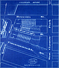 | Details | Fuller and Whitney | 1885 |
| Antique blueprint engineer's plan of Boston's Charlesgate East area |
|
Fuller and Whitney |
|
| 1885 |
| LOC:86 |
| $375.00 | Fuller-and-Whitney | Antique-blueprint-engineer-s-plan-of-Boston-s-Charlesgate-East-area | Original rare cadastral blueprint plan from September 22, 1885 providing detail for a portion of Boston's Back Bay on Beacon Street, Marlborough Street, and Commonwealth Avenue west of West Chester Park (Massachusetts Avenue) and east of Ipswich Street (Charlesgate East). At center left the reader will find the Beacon Entrance to Back Bay Park.
<br></br>
This blueprint, and perhaps other like it, were the end product created from <a href="https://www.rarecharts.com/ShowDetail/Creator/Fuller-and-Whitney/Title/Antique-manuscript-engineers-traced-plan-of-Boston-s-Charlesgate-East-area/2543" target="_blank">a manuscript trace document</a> by William H. Whitney.
</div>
Verso is blank.
<br></br>
During the period 1872 to 1888 Fuller & Whitney Civil Engineers, was conducted as a partnership between J. Franklin Fuller and William H. Whitney with offices at 39 Court Street, Boston, Mass. Whitney assumed sole control of the firm in 1888 and changed the name to William H. Whitney.
<br></br>
In his autobiography Whitney refers to his work with the latest cutting-edge reprographic technology- blueprinting: <div class="indenttextblock">“In September 1881 I received a bronze medal at the Massachusetts Charitable Mechanic Association Exhibit for sun or blue prints. I developed a process from the French and used it in illustrating the growth of Back Bay lands. I issued to subscribers monthly schedules and maps showing the changes of ownership, increase in value, improvement by filling and public works.” (The New England Historical and Genealogical Register. Vol 64, January 1910. Number 253. p. lix).</div> |
| 2541 |  | Details | Fuller and Whitney | 1886 |
| Antique blueprint plan of Boston near Huntington and Massachusetts Avenues |
|
Fuller and Whitney |
|
| 1886 |
| LOC: |
| $300.00 | Fuller-and-Whitney | Antique-blueprint-plan-of-Boston-near-Huntington-and-Massachusetts-Avenues | Original cadastral blueprint plan from Jan. 1, 1886 of a portion of the Boston' Back Bay east of Massachusetts Avenue. The area includes the current location of the Boston Philharmonic Orchestra at 236 Huntington Ave. In the upper portion of the plan an artifact of the blueprint process reveals where a piece of lint or vegetation landed between the surveyor's trace and blueprint paper during exposure of the paper to sunlight.
<br></br>
The area for this blueprint in Boston, Massachusetts is bounded on three sides by Falmouth Street, West Chester Park (now Massachusetts Avenue) and St. Botolph Street. Verso is blank. Sheet is labeled "M". |
| 2543 | 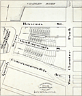 | Details | Fuller and Whitney | 1885 |
| Antique manuscript engineers traced plan of Boston's Charlesgate East area |
|
Fuller and Whitney |
|
| 1885 |
| LOC:86 |
| $500.00 | Fuller-and-Whitney | Antique-manuscript-engineers-traced-plan-of-Boston-s-Charlesgate-East-area | William H. Whitney was a very early adopter of the "blue process" or blueprinting . Both this trace and the <a href="https://www.rarecharts.com/ShowDetail/Creator/Fuller-and-Whitney/Title/Antique-blueprint-engineer-s-plan-of-Boston-s-Charlesgate-East-area/2540" target="_blank">blueprint produced from this trace</a> were created by Whitney just 4 years after the earliest recorded use of blueprints for his Boston-based civil engineering firm.
<br><br>
This rare artifact is the original manuscript cadastral ink trace on tracing cloth from September 22, 1885 providing plan detail for a portion of the Boston Back Bay on Beacon and Marlborough Streets and Commonwealth Avenue west of West Chester Park (Massachusetts Avenue) and east of Ipswich Street (Charlesgate East). This trace would have been used as the reproducible master source to create one or more blueprints, then a new reprographic technology.
<br><br>
With Fuller & Whitney's ink oval over stamp. MS number in pencil at bottom right: "1277".
<br></br>
</div> |
| 1333 | 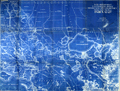 | Details | U.S. War Department | 1934 |
| Old War Department Map of New Orleans Area 1934 |
|
U.S. War Department |
|
| 1934 |
| LOC:1401 |
| $450.00 | U-S--War-Department | Old-War-Department-Map-of-New-Orleans-Area-1934 | Large, original War Department / U.S. Corps of Engineers blueprint index map from 1934 for south-eastern Louisiana including New Orleans, Donaldsonville, Baton Rouge, Mandeville, Slidell and Bay St. Louis. Names railways, numerous waterways and bodies of water, but does not show roads or highways. Includes the Bonnet Carre Floodway (completed 1931), the Harvey Locks, portions of the Intracoastal Canal (later called the Gulf Intracoastal Waterway or ICWW), Lake Borgne, Lake Ponchartrain, Barataria Bay, Atchafalaya Bay, and the Mississippi River as far south as Venice, Louisiana. Perfect for the man cave.
<br></br>
On this map the route shown for the Intracoastal Canal passes through Lockport, Louisiana and Bayou Terrebonne. The segment of the canal from Larose to Bourg, Louisiana to was not completed until 1949.
<br></br>
Dated within at bottom right to 1934. Drawn by L. Lecaze. |
| 5274 | 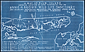 | Details | Pepin, A. L. | 1931 |
| Map Plum Island Annie H. Brown Wild Life Sanctuary |
|
Pepin, A. L. |
|
| 1931 |
| LOC:10 |
| $550.00 | Pepin--A--L- | Map-Plum-Island-Annie-H--Brown-Wild-Life-Sanctuary | An unrecorded cyanotype (blueprint) map of Plum Island from 1931 related to early conservation efforts on the Massachusetts coast. The map shows the location of land purchased for the Annie H. Brown Wildlife Sanctuary and several adjacent properties proposed for purchase.
<br></br>
Plum Island is a New England barrier island that lies on the coast of Massachusetts about two miles from Newburyport, Mass. Plum Island, 11 miles in length, is named for the beach plum shrubs that grow in the dunes. The North Point of the island is located at the mouth of Newburyport Harbor, where the Atlantic Ocean meets the Merrimack River.
<br></br>
Legend at bottom describes seven numbered tracts of land on the map:
<div class="indenttextblocksingle">
<ul style="list-style-type: circle;">
<li>300 acres - Annie H. Brown Wildlife Sanctuary.</li>
<li>110 acres - Land of Knobbs Beach Associates.</li>
<li>225 acres - Land of Woodworth.</li>
<li>90 acres - Land of Stafford.</li>
<li>75 acres Land of Clement.</li>
<li>400 acres - Land of Bar Island realty Company.</li>
<li>3 acres - Land of Small.</li>
</ul>
</div>
Annie Hamilton Brown, a resident of Stoneham, willed a sum of between $15,000 and $25,000 to the Federation of the Bird Clubs of New England in 1929. Working with the Massachusetts Audubon Society, the federation was able to purchase most of the southern end of Plum Island for a wildlife sanctuary. In 1943, the Audubon Society sold the 1,600 acre sanctuary to the Federal Government who merged the land into the Parker River National Wildlife Refuge. This item includes the original fund-raising transmittal letter and return envelope from the Federation of the Bird Clubs of New England, Inc. Laurance B. Fletcher, Secretary; Boston, Massachusetts.
<br></br> |