| | Thumbnail | | Creator | Date | Title / Author / Date / Location | Price | | | Description |
| 668 | 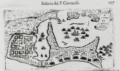 | Details | Coronelli, Vincenzo | 1690 |
| Cartagena, Colombia |
|
Coronelli, Vincenzo |
|
| 1690 |
| LOC:0 |
| | Coronelli--Vincenzo | Cartagena--Colombia | SOLD<br></br>
Colonial period map of Cartagena, Colombia or Cartagena de Indias from the Isolario or island book of Vincenzo Coronelli published from Venice in 1690. Original copperplate engraved chart on a half sheet. Number 157. Italian text on verso. |
| 3637 | 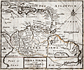 | Details | Moll, Herman | 1701 |
| Moll's fine map of Terra Firma or Northern South America |
|
Moll, Herman |
|
| 1701 |
| LOC:5 |
| $0.00 | Moll--Herman | Moll-s-fine-map-of-Terra-Firma-or-Northern-South-America | SOLD <br></br>Herman Moll's scarce map of Terra Firma and the Caribbean Islands. No sale of this item is recorded in AMPR in the last 17 years.
<br></br>
Covers from Cuba south as far as the Amazon River. Includes the modern day nations of Colombia, Venezuela, Ecuador, Guyana and Brazil. Moll notes the city of Manoa and the location of El Dorado (lost city of gold) west of the Prime or Parima Lake.
<br></br>
During Spain's New World Empire, its mainland coastal possessions bordering the Caribbean Sea and the Gulf of Mexico were referred to collectively as the Spanish Main. The southern portion of these coastal possessions were known as the Province of Tierra Firme ( Terra Firma ), or the "Mainland province".
(Source Wikipedia. https://en.wikipedia.org/wiki/Province_of_Tierra_Firme)
<br></br>
From Moll's "A System of Geography: Or A New and Accurate Description of the Earth In all its Empires, Kingdoms and States" (London), 1701. |
| 2485 | 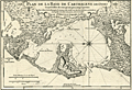 | Details | Anville, Jean Baptiste Bourguignon d' | 1730 |
| Fine antique plan of the Bay of Cartagena, Colombia |
|
Anville, Jean Baptiste Bourguignon d' |
|
| 1730 |
| LOC:5 |
| $700.00 | Anville--Jean-Baptiste-Bourguignon-d- | Fine-antique-plan-of-the-Bay-of-Cartagena--Colombia | Early and very scarce map of the area surrounding Cartagena, Colombia in northern South America. Hilly or mountainous areas are shown in relief. With depth soundings of the channel from Boca Chica into the inner harbor at Cartagena.
<br></br>
From Charlevoix's history of the Caribbean.
Noted features on this copper-plate engraved plan of Cartagena include
<div class="indenttextblock">
<ul style="list-style-type: circle;">
<li>La Cienega de Tesca</li>
<li>Mancanillo</li>
<li>La Madre de Popa ou Nuestra Senora de la Candelaria (a hilltop religious complex dating to 1607).</li>
<li>Boca Chica (entrance to Cartagena Bay)</li>
<li>La Isla de Varu</li>
<li>Paso a Caballos</li>
<li>Isla de Brugas</li>
<li>el Fuerte de Santa Cruz</li>
</ul>
</div> |
| 1441 | 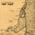 | Details | Popple, Henry | 1742 |
| Antique coastal chart including Cartagena, Colombia |
|
Popple, Henry |
|
| 1742 |
| LOC:0 |
| $0.00 | Popple--Henry | Antique-coastal-chart-including-Cartagena--Colombia | SOLD <BR> </BR>
Interesting and uncommon chart fragment of the coast of Colombia, South America in the vicinity of Cartagena (Cartagene). Other noted locations on this small antique chart include Boquilla, Boca Serada, Grand Bara (Isla Grande), Boca Chica, I. de Stesoro, Punta de Gigantes, Bay de Mattanilla. Pasacaballos is located with the notation in Spanish "Estere de Paso Cavallas". Without more knowledge of Colombian history my guess is that the location was known as place near the river's mouth to ford the river with horses.
<br></br>
This antique map was originally published by Covens and Mortier in 1742 in "Les Principales Forteresses Ports etc. de L'Amerique Septentrionale" a sheet containing harbor and island maps and plans of the Americas. This map is a fragment trimmed from the larger sheet.
<br></br>
That sheet of 18 maps and plans of islands and harbors was published by Covens and Mortier to replace Popple's original large map of 20 sheets with a more manageable six-sheet version. Popple's original map was titled: "A Map of the British Empire in America with the French, Spanish and the Dutch Settlements adjacent thereto". |
| 2484 | 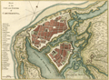 | Details | Jefferys, Thomas | 1762 |
| Jefferys' scarce plan of the city of Cartagena, Colombia |
|
Jefferys, Thomas |
|
| 1762 |
| LOC:13 |
| $800.00 | Jefferys--Thomas | Jefferys--scarce-plan-of-the-city-of-Cartagena--Colombia | Scarce large-scale birds-eye plan of the city of Cartagena, Colombia (1762) by engraver Thomas Jefferys. Emphasis on the considerable defences of Cartagena with more than one dozen defensive bastions identified by name. Secondary fortified position is labeled "Xemani or the suburb." Shows Fort Saint Philip- St. Lazaro or Baraxas and the long road to Bosquilla. Plate 5 Page 13.
<br></br>
After an apprenticeship to Emmanuel Bowen, Thomas Jefferys was one of the more prominent commercial cartographers in London during the middle of the eighteenth century. Although he was responsible for a wide variety of prints and for maps of much of the world, he is particularly remembered for his publication of many maps of North America.
<br></br>
Upon George III's accession to the throne in 1760, Jefferys became "Geographer to the King", a title signifying the status of a favored tradesman, and a reputable publisher with a sufficiently large collection of maps to fill the King's personal needs. Later, bankruptcy forced Jefferys into a partnership with Robert Sayer, a successful publisher of a diverse range of materials. Sayer provided the capital to reprint many of Jefferys' existing plates and presumably took the larger share of the profits. <a href="http://www.oshermaps.org/special-map-exhibits/percy-map/jefferys-and-north-america" target="_blank">(Online. Osher Map Library.)</a> |
| 2535 | 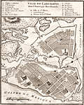 | Details | Bellin, Jacques Nicolas | 1764 |
| Interesting antique plan of Cartagena Colombia |
|
Bellin, Jacques Nicolas |
|
| 1764 |
| LOC:88 |
| $250.00 | Bellin--Jacques-Nicolas | Interesting-antique-plan-of-Cartagena-Colombia | A very interesting plan of the walled city of Cartagena, Colombia in South America with North oriented to the bottom left. Cartagena was an important hub of the Spanish empire in South America. The plan includes a key at top that identifies the important public buildings, numerous churches, powder magazine, prison and fortifications. Unlike other maps and plans of the period this map provides little detail of the hydrographic nature of the surrounding bay.
<br></br>
Cartagena, a major port, was founded in 1533, and named after Cartagena, Spain, which in turn was named after Carthage in Tunisia. Settlement in the region around Cartagena Bay by various indigenous peoples dates back to 4000 BC. During the Spanish colonial period Cartagena served a key role in administration and expansion of the Spanish empire.
<br></br>
From J.N. Bellin's "Le Petit Atlas Maritime: Recueil de Cartes et de Plans des Quatre Parties du Monde" (Small maritime atlas: collection of maps and charts of the four parts of the world), in five volumes containing 581 maps in total. |
| 1282 | 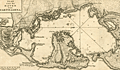 | Details | Tirion, Isaac | 1765 |
| Scarce antique plan or chart of Cartagena, Colombia |
|
Tirion, Isaac |
|
| 1765 |
| LOC:0 |
| $0.00 | Tirion--Isaac | Scarce-antique-plan-or-chart-of-Cartagena--Colombia | SOLD
<br></br>
Detailed antique harbor plan or chart of the bay and surrounding area near <b>Cartagena</b> (Carthagena) Columbia. At left of this fine map is shown the the small walled village of Carthagena. Most place names and features are in Spanish, including <b>Tierra Bomba</b>, Fort de Manzanillo, Castillo Grande, Fort de San Yago, Castillo de San Luiz, and near the village, Fort de San Felipe de Baraxas. The pass into the bay near the village of Cartagena was impassable even at that time as it is marked "Boca Cerrada".
<br></br>
The city, a major port, was founded in 1533, and named after Cartagena, Spain, which in turn was named after Carthage in Tunisia. Settlement in the region around Cartagena Bay by various indigenous people dates back to 4000 BC. During the Spanish colonial period Cartagena served a key role in administration and expansion of the Spanish empire.
<br></br>
Isaac Tirion (d. 1769) was an Amsterdam publisher. This plan of Cartagena, Colombia was published I Tirion's ' Nieuwe en beknopte handatlas' ca. 1765. |
| 6333 |  | Details | Mondhare, Louis-Joseph | 1780 |
| Fine vue d'optique of 17th century Cartagena, Colombia |
|
Mondhare, Louis-Joseph |
|
| 1780 |
| LOC:89 |
| $250.00 | Mondhare--Louis-Joseph | Fine-vue-d-optique-of-17th-century-Cartagena--Colombia | Detailed original view of the walled city of Cartagena de Indias, (now in Colombia, SA) during an attack by the French in 1697. This vue d'optique "Vue de la Ville de Carthagene, en Amerique, Prise par les Francois en 1667", was engraved by Louis-Joseph Mondhare (1734- 1799) ca. 1780. |
| 6698 | 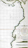 | Details | Direccion Hidrografia | 1800 |
| Rare Spanish chart of northwest South America exploration |
|
Direccion Hidrografia |
|
| 1800 |
| LOC:68 |
| $1,800.00 | Direccion-Hidrografia | Rare-Spanish-chart-of-northwest-South-America-exploration | A scarce, finely engraved original nautical chart of the northwest coast of South America from 1800. With the logo of the Deposito Hidrografico. Shows the tracks of Malaspina aboard the Descubierta and Atrevida (1). In the area of Ecuador the map is overlaid with the lines of the triangulation survey of La Condamine (2). Engraved by Fernando Selma. Dedicated to Don Antonio Cornel.
<br><br>
Shows the erupting volcano "Sangay" in Ecuador's eastern cordillera near to La Condamine's survey location.
<br><br>
(1) Malaspina Expedition - a voyage of scientific exploration sponsored by the Spanish government in the late 18th century. Led by Alejandro Malaspina the expedition set sail in 1789 with the aim of exploring and mapping the coasts of South America, Alaska, and the Philippines. The expedition included scientists, cartographers, and artists, and was one of the most extensive scientific expeditions of its time.
<br><br>
(2) Charles Marie de La Condamine was a French geographer, mathematician, and explorer who lived from 1701 to 1774. La Condamine conducted a triangulation survey near Quito, Ecuador and other locations during his expedition to South America. His goal was to measure the length of a degree of arc at the equator, which helped to confirm the shape of the Earth as an oblate spheroid. La Condamine also made important contributions to the study of Amazonian geography and culture, and he was one of the first Europeans to provide a detailed account of rubber. |
| 5262 | 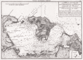 | Details | Direccion Hidrografia | 1816 |
| Rare harbor chart of Cartagena, Colombia |
|
Direccion Hidrografia |
|
| 1816 |
| LOC:88 |
| $0.00 | Direccion-Hidrografia | Rare-harbor-chart-of-Cartagena--Colombia | Sold<br><br>Rare harbor chart of Cartagena, Colombia. North is oriented to the right. Numerous soundings and hazards are marked. Plate Number 19.
<br></br>
Published in 1809, this large-scale port/harbor chart is one of 41 charts of ports in Part II of the atlas "Portolano de la America Septentrional Construido en la Direccion Detrabajos Hidrograficos" containing charts from the USA (Florida and Texas), Mexico, Nicaragua, Panama, and Colombia. Because of Spain's secrecy about its New World territories this chart represents the earliest easily available cartographic record of this area from Spanish sources. |
| 4817 | 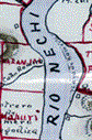 | Details | deHora, Manuel Herrera | 1913 |
| Antique Manuscript Gold-mining Map Antioquia Region in Colombia |
|
deHora, Manuel Herrera |
|
| 1913 |
| LOC:62 |
| $2,100.00 | deHora--Manuel-Herrera | Antique-Manuscript-Gold-mining-Map-Antioquia-Region-in-Colombia | Early <b>gold-mining map</b> in manuscript pen and ink on surveyor's tracing "cloth" by New York based mining engineer <b>Manuel Herrera de Hora</b> (1849-1934). Rare manuscript trace document of the gold field leases, including Oroville Dredging Company, near the Nechi River in Colombia, S.A. ca. 1913. For use in reproducing multiple blueprint (cyanotype) copies of the map.
<br></br>
<div class="indenttextblock">
"In my opinion, there is <b>no part of the world so favorable for investment</b> and so <b>attractive from the gold miner’s point of view</b> as the Department of Antioquia. [Colombia]"
<br></br>
"Dredgeman's paradise".
<br></br>
</div>
In his <a href="/ZoomifyImages/SC_4817/de Hora 2.pdf" target="_blank">presentation</a> to the American Institute of Mining Engineers in August 1913 de Hora made the business case for the profits that could be made using barge-mounted dredges to mine the thick gravel placer gold deposits along the Nechi, Cauca, and Porce Rivers near Zaragoza in Colombia's Antioquia department.
<br></br>
In his analysis de Hora reviews the history of gold-mining in the Antioquia region, describes topography and the physical properties of the region's gold, estimates risks and resource availability, and provides useful information on Colombia's liberal mining laws and climate. (de Hora, M.H. The Gold Placers of Antioquia, Republic of Colombia, South America. Bulletin American Institute of Mining Engineers. July 1913. p. 1197.)
<br></br>
The New York Times <a href="/ZoomifyImages/SC_4817/Manuel deHora.pdf" target="_blank">obituary</a> of de Hora in 1934 reads like chapters in an adventure novel:
<div class="indenttextblock">
<li>COLONEL DE HORA ADVENTURER, DIES</li>
<li>As Soldier of Fortune and a Mining Engineer Had a Thrilling Career.</li>
<li>Shanghied in his Youth</li>
<li>Reported to have Seized a Warship and Steamer--A Police Chief in South Africa</li>
</div> |