| | Thumbnail | | Creator | Date | Title / Author / Date / Location | Price | | | Description |
| 8000 | 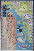 | Details | Exploration Cruise Lines | 1985 |
| Cool pictorial cruise poster of Alaska |
|
Exploration Cruise Lines |
|
| 1985 |
| LOC:130 |
| $365.00 | Exploration-Cruise-Lines | Cool-pictorial-cruise-poster-of-Alaska | Rare possibly unrecorded large format travel poster for Exploration Cruise Lines ca. 1985.
<br><br>
This promotional poster for Exploration Cruise Lines presents a stylized map of Alaska and the Pacific Northwest, built around the slogan “Nobody Gets You Closer to Alaska.” The map combines illustrated geographic features—such as Glacier Bay, Frederick Sound, the Gulf of Alaska, Yakutat Bay, and the Inside Passage—with small icons marking wildlife including bears, eagles, whales, seals, and mountain goats. Port calls and route segments are clearly labeled: Sitka, Juneau, Ketchikan, Wrangell, Petersburg, Seward, Prince Rupert, and other locations appear along color-coded itineraries for the Great Rivers Explorer and Pacific-Northwest Explorer. Insets summarize key regions (“Outside, the Inside Passage,” “Yakutat Bay,” “The Inside Passage and Beyond,” and “Alaska for the Independent Traveler”), highlighting landmarks such as Columbia Glacier, Hubbard Glacier, the Kenai Peninsula, Denali National Park, and the Misty Fiords National Monument.
<br><br>
The lower section features a large depiction of an Exploration Cruise Lines vessel entering Alaskan waters, together with the company’s name and sunburst logo. Text blocks emphasize the line’s focus on remote scenery, wildlife viewing, and smaller-ship access to narrow channels and glacial bays. A sidebar provides a simplified Inside Passage index and distances between ports, reinforcing the company’s claim of operating close-in routes not accessible to larger cruise ships. As a surviving piece of cruise-line ephemera from a short-lived 1980s operator, the poster documents how Exploration Cruise Lines marketed its Alaskan itineraries and presents a period design that blends infographic mapping with illustrative regional imagery. |
| 6701 | 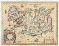 | Details | Blaeu, William Janszoon | 1650 |
| Tabula Islandiae Auctore Georgio Carolo Flandro |
|
Blaeu, William Janszoon |
|
| 1650 |
| LOC:86 |
| $700.00 | Blaeu--William-Janszoon | Tabula-Islandiae-Auctore-Georgio-Carolo-Flandro | A fine 17th century map of Iceland priced to sell.
<br><br>
This map of Iceland, "Tabula Islandiae Auctore Georgio Carolo Flandro", was engraved for William Janszoon Blaeu and first published in his firm’s Atlas Novus. The plate is based on surveys by the Dutch navigator Georgius Carolus Flandrus (Joris Carolus), one of the few early European seafarers to chart northern waters. The map depicts Iceland with stylized mountain ranges, rivers, and settlements identified in Latin and Icelandic. Surrounding seas are filled with ships and sea creatures, and a large title cartouche occupies the lower right. The imprint “Guiljelmus Blaeuw” identifies the plate as one originally engraved for Willem before his death in 1638.
<br><br>
The verso text, printed in Dutch, places this example within the early Dutch-language edition of the Toonneel des Aerdrycks issued in Amsterdam around 1648–1650, when the Blaeu firm was transitioning from William to his son Joan. Printed from the original copperplate, this state retains the strong, clean impression of the earliest issues and represents one of the most well known mid seventeenth-century maps of Iceland. The map’s enduring design remained in use for more than two decades and set the cartographic standard for the island until the late eighteenth century.
<br><br> |
| 5135 | 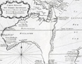 | Details | Prevost, Antoine-Francois | 1753 |
| Histoire générale des voyages tome onzième v 11 |
|
Prevost, Antoine-Francois |
|
| 1753 |
| LOC:2001 |
| $1,750.00 | Prevost--Antoine-Francois | Histoire-générale-des-voyages-tome-onzième-v-11 | Volume 11 of Prevost's history of voyages to the south sea. Contains accounts of the explorations of Narborough, Wood, Anson, Dampier, Carieri and others. Plates of unusual animals and six plates of botannicals with copper-engraved maps as below. <b>Includes two very desirable, foundational maps of Australia</b> with the continent shown attached to Tasmania:
<div class="indenttextblocksingle">
<ul style="list-style-type: circle;">
<li>"Carte reduite des Terres Australes pour servir …" by Nicolas Bellin. 1753. (11" x 8"). Very good.</li>
<li>"Carte reduite de la Mer du Sud pour servir ..." by Nicolas Bellin. 1753. (14" x 8"). Good. </li>
</ul>
</div>
French text. Volume 11- tome onzième. Second Partie. "Histoire Generale des voyages, ou nouvelle collection de toutes les relations de voyages par mer et par Terre, qui ont ete publiees jusqu'a present dans les differentes langues de toutes les nations connue …". Published by Didot from Paris in 1753.
<br></br>
Contents include but are not limited to these plates:
<div class="indenttextblocksingle">
<ul style="list-style-type: circle;">
<li>Carte reduite de la partie la plus meridionale de l'Amerique No. 1</li>
<li>Carte reduite du Detroit de Magellan No. 2</li>
<li>Carte de l'Isle de Caienne No. 3</li>
<li>La Ville de Cayenne No. 4</li>
<li>Carte du Detroit de le Maire No. 5</li>
<li>Carte particuliere de l'Isle de Juan Fernandez No. 6</li>
<li>Coste du Nord Est de l'Isle de Juan Fernandez No. 7</li>
<li><b>Carte reduite des Terres Australes No. 8</b></li>
<li><b>Carte reduite de la Mer du Sud No. 9</b></li>
<li><b>Representation du cours ordinaires des vents … Mer du Sud</b> No. 10</li>
<li>Vue de la Place de Juan Fernandez No. 13</li>
<li>Batiment leger des Isles de Larrons No. 14</li>
</ul>
</div> |
| 4825 | 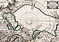 | Details | Picart, Jean | 1657 |
| Scarce original engraving of the North Polar Region |
|
Picart, Jean |
|
| 1657 |
| LOC:13 |
| $480.00 | Picart--Jean | Scarce-original-engraving-of-the-North-Polar-Region | Picart's map of the North Pole (second state) based on Jansson's Septentrionalium Terrarum Descript from the Atlas Minor. An early map of the Arctic region seldom found in this fine condition. |
| 3630 | 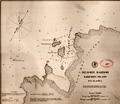 | Details | U.S. Coast and Geodetic Survey | 1888 |
| Early chart of St. John Harbor, Zarembo Island, Alaska |
|
U.S. Coast and Geodetic Survey |
|
| 1888 |
| LOC:10 |
| $300.00 | U-S--Coast-and-Geodetic-Survey | Early-chart-of-St--John-Harbor--Zarembo-Island--Alaska | Early chart of St. John Harbor on Zarembo Island in S.E. Alaska. Printed by the U.S. Coast and Geodetic Survey as a separately issued harbor chart for a price of 15 cents at the time.
<br></br>
Zarembo Island is an island in the Alexander Archipelago of southeastern Alaska, United States. It lies directly south of Mitkof Island and northwest of Etolin Island.
<br></br>
Rare to find old Coast Survey charts of this remote an area on such heavy paper. With red stamp of the U.S. Geological Survey library. Chart is believed to have been an institutional file copy. |
| 2562 | 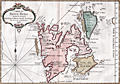 | Details | Bellin, Jacques Nicolas | 1758 |
| Antique French map of Spitsbergen, Norway |
|
Bellin, Jacques Nicolas |
|
| 1758 |
| LOC:88 |
| $270.00 | Bellin--Jacques-Nicolas | Antique-French-map-of-Spitsbergen--Norway | Fine 18th-century antique French map of Spits-berg (Spitsbergen), in today's Svalbard Islands - in northern Norway; the largest Norwegian island. One of the most northern regions to be discovered by Europeans, the place names seen here reflect the nationalities of those early travellers, English, Dutch, Scandinavian and French. Spitsbergen was first used as a whaling base in the 17th and 18th centuries.
<br></br>
The first known sighting of Spitsbergen by a European was by Willem Barentsz, who came across it in 1596 while searching for the Northern Sea Route.
<br></br>
Published in a French edition of L'Abbe Prevost's "Histoire Générale des Voyages", less than twenty years before Captain Cook's famous voyage. Page 192. Book 17. |
| 2507 | 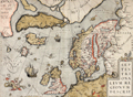 | Details | Ortelius, Abraham | 1570 |
| Scarce map of the Arctic and Scandinavia |
|
Ortelius, Abraham |
|
| 1570 |
| LOC:10 |
| $2,200.00 | Ortelius--Abraham | Scarce-map-of-the-Arctic-and-Scandinavia | Ortelius' map of the Arctic, including Scandinavia, Iceland, Greenland and part of the North American continent, includes the legendary islands of Drogeo, Frisland and Icaria. This fine map, with original color, is adorned with a variety of very inventive creatures including a half-man, half-sea creature with bird feet playing a lute. Second state with a triangular dot added at the end of the title. |
| 2502 | 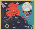 | Details | Chase, Francis J. | 1935 |
| The Last Frontier |
|
Chase, Francis J. |
|
| 1935 |
| LOC:10 |
| $350.00 | Chase--Francis-J- | The-Last-Frontier | Colorful and fun pictorial map of Alaska with pictures of flora, fauna, and native peoples. Prominently features the Japanese Current. Key named locations include Seattle, Bristol Bay, Aleutian Islands, Point Hope, and Point Barrow. Oceans colored black, with whales, local ships, a compass rose, iceberg, and rising sun. Rope-bordered cartouche decorated with nautical subjects, fishermen, float plane, and a totem pole.
<br></br>
Designed by J. Francis Chase. Copyright 1935 by Abbott Laboratories, North Chicago, Ilinois, producers of Abbott's Haliver Oil, a nutritional supplement derived from the liver of the halibut. |
| 1424 | 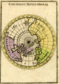 | Details | Mallet, Allain Manesson | 1685 |
| Antique Northern Hemisphere Polar Map |
|
Mallet, Allain Manesson |
|
| 1685 |
| LOC:41 |
| $90.00 | Mallet--Allain-Manesson | Antique-Northern-Hemisphere-Polar-Map | Small, hand-colored antique view of the northern hemisphere from a north polar perspective. Shows the so-called "Arctic Lands" with Greenland connected to northern Canada. Shows Iceland, Spitsbergen, and the "Terre de Iesso" or the Japanese island of Hokkaido . Fig 16.
<br></br>
By Allain Mallet, Paris, 1683 in a German edition of "Description de l'Univers" . Allain Mallet (1630-1706) was a French engineer, soldier, and cartographer. He served in the court of King Louis XIV as a techer of mathematics. In addition to "Description de l'Univers" Mallet also published "Les Travaux de Mars ou l'Art de la Guerre". |
| 1362 | 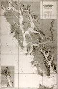 | Details | Depot de la Marine | 1902 |
| Antique nautical chart of southern Alaska, Prince of Wales Island, Juneau |
|
Depot de la Marine |
|
| 1902 |
| LOC:2001 |
| $1,200.00 | Depot-de-la-Marine | Antique-nautical-chart-of-southern-Alaska--Prince-of-Wales-Island--Juneau | Fine nineteeth-century folding Gold-Rush era nautical chart of southwest Alaska from Graham Island/Dixon Entrance past Prince of Wales Island, and terminating with Glacier Bay. Large, separately issued French chart of the Alaska Panhandle and the inside passage. Includes part of the route used by modern cruise ships visiting Juneau or Haines or Skagway, Alaska. Inset of "Extremite nord du Canal Lynn".
<br></br>
Published first in 1893, this edition contains corrections to 1902. Early charts of Alaska are scarce. No copies of this antique chart are listed in OCLC/WorldCat or in the Antique Map Price Record.
<br></br>
Some of the many named features on this fine chart include Admiralty Island, Cross Sound, Baranoff Island, Dall Island, and Wrangell Island, Chatham Canal, Port Protection (of TV fame), Haines, and the Skagway River. Numerous mountains with elevation details as well as many glaciers are identified and named.
<br></br>
With owners overstamps from the Library of Canadian Energy, Mines, and Resources Department in 1969 and 1976. Number 4553. |
| 1344 | 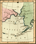 | Details | Luffman, John | 1802 |
| Behrings Strait and Alaska engraved for Luffman's Select Plans |
|
Luffman, John |
|
| 1802 |
| LOC:3 |
| $280.00 | Luffman--John | Behrings-Strait-and-Alaska-engraved-for-Luffman-s-Select-Plans | Scarce and attractive antique copper-plate engraved map of the Bering (Behring) Strait and Gulf of Alaska by John Luffman. This small but fine map extends past 70 degrees north latitude. The Bering Strait is a narrow body of water that links the Arctic Ocean with the Bering Sea and separates the continents of Asia and North America ( Alaska ) at their closest point. Some portions of the Alaska and Asia coasts not well explored at the time are shown with dotted lines, reflecting the uncertainty about their geography.
<br></br>
Key locations noted by Luffman include Bristol Bay, Cook River, Cape Prince of Wales, Cape Stephens, Cape Mulgrave, Cape Lisburn, Round Island, Norton Sound, and Trinity Island at the southern tip of the Kodiak Archipelago (not shown in its entirety).
<br></br>
Bering's strait averages 100 to 165 feet in depth and at its narrowest point is about 53 miles wide. About 20,000 years ago, during the Ice Age, the sea level fell by several hundred feet, making the strait into a land bridge between Asia and North America, over which the migration of plants and animals and humans occurred.
<br></br>
From "Luffman's Select Plans of the Principal Cities, Harbors, Forts etc. in the World". Engraved and published by John Luffman, No. 28 Little Bell Alley, Coleman Street, February, 1802. Volume II; Number 67.
<br></br> |
| 1292 | 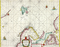 | Details | Doncker, Hendrick | 1664 |
| Antique nautical chart of Norway, Spitsbergen, Greenland, and Russia |
|
Doncker, Hendrick |
|
| 1664 |
| LOC:200 |
| $1,500.00 | Doncker--Hendrick | Antique-nautical-chart-of-Norway--Spitsbergen--Greenland--and-Russia | Scarce copper-engraved sea chart of Spitsbergen, Norway and to the west, the largely unknown shores of Greenland. by cartographer Hedrick Doncker, Amsterdam. Coverage on this very attractive antique sea chart includes "Finnmarken" (Norway), "Lapland", "Nieu Groenlandt", Jan Mayen Island, Svalbard ("Spitsbergen"), "Nova Zemla", and Russia with Arkhangelsk ("Archangel"). Shows a longer coastline for Greenland than later editions of the same map by Doncker. Dated within to 1664.
<br></br>
Hendrick Doncker (1626-1699) was an Amsterdam printer, bookseller, and cartographer residing in the Nieuwe Bruchsteegh in Stuurmans Gereetschap. |
| 1192 | 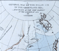 | Details | Manby, George William | 1823 |
| Journal of a Voyage to Greenland, in the year 1821 |
|
Manby, George William |
|
| 1823 |
| LOC:0 |
| $1,800.00 | Manby--George-William | Journal-of-a-Voyage-to-Greenland--in-the-year-1821 | An arctic whaling classic. Scarce second edition (1823) of this illustrated account of the whaling ship Baffin’s voyage with Captain Scoresby. The main purpose of the voyage was to test a new harpoon design by Scoresby. The voyage took them first to Spitzbergen, along the coast of Greenland, to Iceland and then home.
<br></br>
George Manby accompanied Captain Scoresby on the voyage into the northern Greenland Sea aboard the whaling ship Baffin. Manby creates a vivid picture of Arctic whaling as it was practiced during the early part of the 19th Century. Scoresby invented a harpoon gun and is also remembered for his life-saving apparatus. Numerous woodcuts in the text of whales, narwhal, and other arctic creatures.
<br></br>
With a fine hand-colored folding map "A General Map of the Polar Ice in the Greenland Sea and Track of the Ship Baffin in the Summer of 1821 by G.W. Manby (14" x 10"). Contains 20 uncolored lithographic plates illustrating the voyage. Five plates "Drawn on stone by J.D. Harding" are larger and folded:
<div class="indenttextblock">
<ul style="list-style-type: circle;">
<li>Striking a Whale with Third Harpoon</li>
<li>A Whale Upsetting a Boat</li>
<li>Lancing a Whale</li>
<li>A Bear Attacking A Boat</li>
<li>A Boat Going on the Tail of a Fish</li>
</ul>
</div>
In 1819 William Scoresby moved to Liverpool from Whitby where he built (1820) and commanded the whaling ship "Baffin". In 1822 Scoresby mapped the East coast of Greenland. The "Baffin" finally sank in 1830 when 19 out of 90 ships in the whaling fleet were lost in bad weather in the Davis Strait. Scoresby's plans, together with this scale model of his ship are in the Whitby Museum, Yorkshire, England.<a href="http://www.whitbymuseum.org.uk/hpmimages/index1.htm " target="_blank"> (Internet. 2016.)</a>
<br></br>
Printed for G. and W.B. Whittaker, Ave Maria Lane, London. 225 pages including an appendix illustrated with woodcuts of harpoons and lance heads. |
| 1150 | 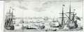 | Details | Narbrough, John | 1694 |
| Early 17th century engraved whaling scene |
|
Narbrough, John |
|
| 1694 |
| LOC:1 |
| $300.00 | Narbrough--John | Early-17th-century-engraved-whaling-scene | Early foldout engraved bookplate (1697) depicting a whaling scene to illustrate Friedrich Martens' observations on northern whaling. Attractive antique print shows multiple whaling ships and ships boats engaged in harpooning, fighting, and flensing whales. A fine gift.
<br></br>
The view lends insight into the methods used to hunt whales in the early 17th century in the whaling grounds of the far northern latitudes like Greenland and the island of Spitsbergen, Norway. For example the ship at far right is shown tied off to an iceberg, a practice noted by Narbrough in the text. <div class="indenttextblock"> "When they sail some Miles into the Ice, where there is pretty large Ice-fields, they joyn their Ships to them with great Ice-hooks, fastned to strong Cables, where they lie at Anchor, several Ships about the same Ice-field, but they rather chose to be alone, because they are an hindrance to one another in Whale catching, and the hunting of them from one to another maketh them shie. (Online: http://darwin-online.org.uk/converted/Ancillary/BeagleLibrary/1694_Narborough_A813.html")</div>
</br>
Originally published in 1694 to accompany "The First Part of the Voyage into Spitsbergen and Greenland.", this record of recent voyages made by Sir John Narborough, Abel Tasman, John Wood and Friderich Martens. Narborough's journal records his voyage to the Straits of Magellan and his interest in the lands and peoples he encountered from 1669 to 1671.
<br></br>
This fine antique print illuminates Friedrich Martens' (1635 - 1699) observations on Spitsbergen and whaling in northern waters in 1671. |
| 385 | 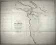 | Details | Parry, William Edward | 1824 |
| Chart of a part of the North Eastern Coast of America [North] |
|
Parry, William Edward |
|
| 1824 |
| LOC:53 |
| $450.00 | Parry--William-Edward | Chart-of-a-part-of-the-North-Eastern-Coast-of-America-[North] | A large chart of the Melville Peninsula and its adjacent islands, including Amherst, Liddon, and Ormond Islands. The chart documents the expedition of the vessels Fury and Hecla from 1822-1823 led by William Edward Parry to find a Northwest passage to the Pacific. Contains the route of the expedition's ships with Cape Englefield and Cape Hallowell off the Fury and Hecla strait as the western-most point. <BR> </BR>
Foldout steel engraving from: "Journal of a second voyage for the discovery of a north-west passage from the Atlantic to the Pacific; performed in the years 1821-22-23, in his Majesty's ships Fury and Hecla, under the orders of William Edward Parry, … ". Published by John Murray, Albemarle Street, London. January 6th, 1824. |
| 386 | 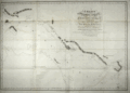 | Details | Parry, William Edward | 1824 |
| Chart of the Northern Shore of Hudson's Strait |
|
Parry, William Edward |
|
| 1824 |
| LOC:53 |
| $400.00 | Parry--William-Edward | Chart-of-the-Northern-Shore-of-Hudson-s-Strait | A large chart of upper Hudson's Strait from Nottingham Island to Resolution Island. The chart documents the expedition of the vessels Fury and Hecla from 1821-1823 led by William Edward Parry to find a Northwest passage to the Pacific. During that expedition Parry explored Repulse Bay and discovered what is now Fury and Hecla Strait. Contains the route of the expedition's ships. <BR> </BR>
Foldout steel engraving from: "Journal of a second voyage for the discovery of a north-west passage from the Atlantic to the Pacific; performed in the years 1821-22-23, in his Majesty's ships Fury and Hecla, under the orders of William Edward Parry, … ". Published by John Murray, Albemarle Street, London. January 6th, 1824. |
| 387 | 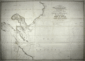 | Details | Parry, William Edward | 1824 |
| Chart of a part of the North Eastern Coast of America [South] |
|
Parry, William Edward |
|
| 1824 |
| LOC:53 |
| $450.00 | Parry--William-Edward | Chart-of-a-part-of-the-North-Eastern-Coast-of-America-[South] | A large chart of Northeastern America with Repulse Bay as the Western-most point.. The chart documents the expedition of the vessels Fury and Hecla from 1821-1822-1823 led by William Edward Parry to find a Northwest passage to the Pacific. During that expedition Parry explored Repulse Bay and discovered what is now Fury and Hecla Strait. Other geographical features on this chart include Cape Frigid, Duke of York Bay, Frozen Strait, Gore Bay, Ross Bay, and Lyon Inlet. <BR> </BR>
Foldout steel engraving from: "Journal of a second voyage for the discovery of a north-west passage from the Atlantic to the Pacific; performed in the years 1821-22-23, in his Majesty's ships Fury and Hecla, under the orders of William Edward Parry, … ". Published by John Murray, Albemarle Street, London. January 6th, 1824. |