| | Thumbnail | | Creator | Date | Title / Author / Date / Location | Price | | | Description |
| 5105 | 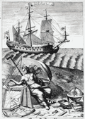 | Details | Blome, Richard | 1685 |
| Original Navigation Engraving by Richard Blome |
|
Blome, Richard |
|
| 1685 |
| LOC:88 |
| $300.00 | Blome--Richard | Original-Navigation-Engraving-by-Richard-Blome | Fine original copper-plate engraving "Navigation" from Gentleman's Recreation by Richard Blome. This plate, as many others in Blome's encyclopedia, was dedicated to an English nobleman. Show's a 17th century square-rigged sailing vessel with charts, a globe, compass and other navigation instruments.
<br></br>
Dedicated to George Legge, Baron of Dartmouth, Master General of the Ordnance and many other titles.
<br></br>
From Blome's "The Gentleman's Recreation. ... An Encyclopedy of the Arts and Sciences ... Horsemanship, Hawking, Hunting, Fowling, Fishing and Agriculture. With a Short Treatise of Cock-Fighting." |
| 5106 | 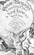 | Details | Collins, Greenvile | 1753 |
| Engraved Frontispiece for Great Britains Coasting Pilot |
|
Collins, Greenvile |
|
| 1753 |
| LOC:88 |
| $350.00 | Collins--Greenvile | Engraved-Frontispiece-for-Great-Britains-Coasting-Pilot | Fine original engraved frontispiece for "Great Britains Coasting Pylot being a new survey of the sea coast by Greenvile Collins Hydrographer to His Majesty." With Poseidon, Britannia, sea nymphs, putti, trumpets, navigation instruments, a chart of the U.K. and one trident. Very attractive.
<br></br>
Sold by William Mount and Thomas Page on Tower Hill, London. |
| 1234 | 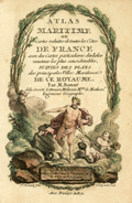 | Details | Bonne, Rigobert | 1778 |
| Antique title page to the miniature Atlas Maritime |
|
Bonne, Rigobert |
|
| 1778 |
| LOC:7 |
| $200.00 | Bonne--Rigobert | Antique-title-page-to-the-miniature-Atlas-Maritime | Scarce antique miniature title page to Rigobert Bonne's miniature sea atlas of coastal France. Bonne's scarce atlas contained 12 miniature nautical charts of coastal France and 18 miniature plates of port and harbor plans. With Table of Contents, colored attractive frontispiecce, and end notes.
<br></br>
From Rigobert Bonne's miniature nautical atlas "Atlas maritime ou Cartes réduites de toutes les Côtes de France avec des cartes particulières des isles voisines les plus considérables, suivies des plans des principales villes maritimes de ce royaume." Published by Lattre from Paris. With the royal privilege. Engraved by Monnet after a design by L. Legrand.
<br></br>
Rigobert Bonne was the successor to Jacques Nicolas Bellin as Royal Cartographer to France in the office of the Hydrographer at the Depôt de la Marine. |
| 1137 |  | Details | Henri Sbonski de Passebon | 1720 |
| Rare title page from de Passebon's engravings of nautical architecture |
|
Henri Sbonski de Passebon |
|
| 1720 |
| LOC:9 |
| $1,850.00 | Henri-Sbonski-de-Passebon | Rare-title-page-from-de-Passebon-s-engravings-of-nautical-architecture | Stunningly beautiful hand-colored engraved title page from Henri Sbonski de Passebon's ca. 1720
<a href="
https://www.rarecharts.com/SbonskiPassebonBackground.aspx" target="_blank">atlas of Mediterranean naval architecture</a>.
<br></br>
Engraved by Simonneau, drawn by Berey. |
| 1056 |  | Details | Michelot and Bremond | 1730 |
| Michelot Title Page - Recueil de Plusieurs Plans des Ports et Rades (2) |
|
Michelot and Bremond |
|
| 1730 |
| LOC:1 |
| $215.00 | Michelot-and-Bremond | Michelot-Title-Page---Recueil-de-Plusieurs-Plans-des-Ports-et-Rades-(2) | Title page to "Recueil de Plusieurs Plans des Ports et Rades de la Mer Mediterranee", <a rel="nofollow" href= "/MichelotBremondBackground.aspx">Henry Michelot and Laurens Bremond's</a> quarto-sized atlas of Mediterranean ports and harbors published between 1727 and 1730. This elaborately engraved title page is very rarely found alone, usually only as one of the 38 plates in a copy of the complete Michelot and Bremond atlas.
<BR> </BR>
Interesting note is that on the bottom neatline, previously engraved wording has been hastily covered over before printing, with just top and bottom of characters still visible. |
| 999 |  | Details | Tassin, Christophe Nicholas | 1636 |
| Antique title page for Dauphiné province in France |
|
Tassin, Christophe Nicholas |
|
| 1636 |
| LOC:50 |
| $95.00 | Tassin--Christophe-Nicholas | Antique-title-page-for-Dauphiné-province-in-France | Beautiful hand-colored, engraved sectional title page for Tassin's small atlas of French towns. This example is for the chapter containing the province of Dauphiné, in southeastern France. This title page with its scrollwork cartouche is topped with a whimical insect head. A very fine example of 17th century engraving craftsmanship and artistry.
<br></br>
Published in the small-sized atlas "Les Plans et profils de toutes les principales villes et lieux considerables de France" by Christophe Nicholas Tassin (d. 1660) . Tassin's background was as a military engineer, and he is best known for his nautical atlas of 30 sheets, dedicated to Richelieu, documenting France's coastline. Tassin's work contains topographic maps, often of militarily important sites, either sketched on site, composed from firsthand drawings by military engineers, or sometimes borrowed from other mapmakers. |
| 920 |  | Details | Vianen, Jan van | 1698 |
| Title Page from Claudii Ptolemaei Tabulae Geographicae… |
|
Vianen, Jan van |
|
| 1698 |
| LOC:0 |
| $250.00 | Vianen--Jan-van | Title-Page-from-Claudii-Ptolemaei-Tabulae-Geographicae… | Antique engraved print. Beautiful copperplate engraved title page from Claudii Ptolemaei Tabulae Geographicae Orbis Terrarum Veteribus Cogniti, engraved by Jan van Vianen. Published by François Halma & Willem van den Water, Utrecht & Leonard Strick, Franeker, in 1698. |
| 660 |  | Details | Tassin, Christophe Nicholas | 1634 |
| Cartes Generale et Particulieres de toutes le costes de France |
|
Tassin, Christophe Nicholas |
|
| 1634 |
| LOC:1 |
| $475.00 | Tassin--Christophe-Nicholas | Cartes-Generale-et-Particulieres-de-toutes-le-costes-de-France | Extraordinary engraved and very scarce 13" x 9" sea-atlas title page by French cartographer Christophe Nicholas Tassin. Contains scrollwork, angels, garlands, and a flat frog-like creature. A beautiful example of 17th century copperplate engraved art. This title page is not from the common series of town views in pocket atlas format published by Tassin.
<br></br>
This title page is from the earliest sea atlas published in France ( 1634 ) by Christophe Tassin. That atlas of 32 plates depicts hydrographic and topographic details of the French coast.
<br></br>
See this site for charts in Tassin's rare atlas: http://gallica.bnf.fr/ark:/12148/btv1b77100033.
<br></br>
Attribution at bottom reads: "Par Sieur Tassin Geographe ordinaire de ca Majeste. Par Privilege du Roy." Tassin's background was as a military engineer. Tassin's work contains topographic maps, often of militarily important sites, either sketched on site, composed from firsthand drawings by military engineers, or sometimes borrowed from other mapmakers. Additionally, Christophe Tassin also published several small sized atlases with profiles of French towns and maps of the provinces.
<br></br>
Published in Paris by Chez Melchior Tavernier, en lisle du Palais, vis à vis la quay de la Megisserie. |
| 469 | 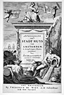 | Details | van Campen, Jacob | 1661 |
| Architecture Title Page |
|
van Campen, Jacob |
|
| 1661 |
| LOC:50 |
| $475.00 | van-Campen--Jacob | Architecture-Title-Page | Beautifully engraved antique title page to a volume of architectural drawings of the Amsterdam state house by artist Jacob Vennekool, after a sculpture by the Dutch sculptor Artus Quellinus. The town hall was built by <strong>Jacob van Campen</strong> during the period 1648-55. The building was itself an emblem of the great commercial successes of the Dutch, successes that were specifically celebrated in rich sculptural decorations.
<br></br>
This superb title page is adorned with putti playing trumpets and with symbols reflecting the importance of navigation and sea exploration to Amsterdam during the late 17th century: ships, anchor, cannon, and three backstaffs, as well as two nude figures representing <strong>New World native Americans.</strong> Less than 50 years earlier, in 1614, the Dutch founded a trading post in lower Manhattan, 'New Amsterdam', later New York.
<BR> </BR>
This page was published by Frederick de Widt (de Wit) in Amsterdam ca. 1661. Wit, a printer, publisher, and map seller, is well known today for the atlases and charts he published from Amsterdam in the mid to late 17th century. |
| 470 |  | Details | Delisle, Guillaume | 1750 |
| Title Page-Atlante Novissimo |
|
Delisle, Guillaume |
|
| 1750 |
| LOC:1 |
| $175.00 | Delisle--Guillaume | Title-Page-Atlante-Novissimo | Undated decorative copperplate title-page from Delisle's Atlas 'Atlante Novissimo'. The atlas was published from Venice, Italy in 1750. As the author's name is spelled 'Guglielmo' we assume this engraving is from an Italian edition of the atlas. Bottom vignette contains a view of St. Marks square in Venice with the Campanile to the left. |
| 445 |  | Details | Bellin, Jacques Nicolas | 1772 |
| Hydrographie Francoise (Title Page) |
|
Bellin, Jacques Nicolas |
|
| 1772 |
| LOC:55 |
| $400.00 | Bellin--Jacques-Nicolas | Hydrographie-Francoise-(Title-Page) | Gorgeous copperplate re-strike engraving of the title page to Bellin's sea-atlas, the Hydrographie Francoise. With the circular stamp of the Depot de la Marine. Undated. Price One and one-half francs. No. 1.
<BR> </BR>
We believe the engraving is an early 20th century re-strike from the original copper plate produced at the French Chalcographie du Louvre. La Chalcographie du Louvre is a repository, consisting of more that 13,000 original plates from the Louvre's archives, housed upstairs above the Louvre's Paris galleries . Upon request visitors can have an engraving produced from the original plate on museum-quality paper by a master printer. V.196. |
| 423 | 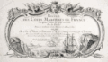 | Details | Le Rouge, George | 1757 |
| Title Page from Recueil des Cotes Maritimes de France |
|
Le Rouge, George |
|
| 1757 |
| LOC:0 |
| $150.00 | Le-Rouge--George | Title-Page-from-Recueil-des-Cotes-Maritimes-de-France | Title page from an atlas of the coasts of France, "Recueil des Cotes Maritimes de France", printed in 1757. The copperplate engraving shows a scene of ships navigating near a rocky coast inset into a decorative scroll-work cartouche decorated with implements of war. Dedicated to the Comte de Clermont.<BR> </BR>
<b>George Le Rouge<b> (1712-1790)was a German-born Paris-based engineer and surveyor who had a shop on the Rue des Grands Augustins. Le Rouge's tireless work for the King earned him the title <b>"Geographe du Roi". </b>
<BR> </BR>
Le Rouge's important works include his edition of the Franklin/ Timothy Folger chart of the Gulf Stream (after Franklin [1]) " and the Pilote américain septentrional (1778) which published Plan de Boston avec les Sondes et les Directions pour la Navigation : traduit de l'Anglais" and "Ocean Atlantique et Mers Adjacentes en quatre feuilles…"
[1] Mount and Page. London. 1768. |
| 216 | 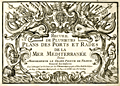 | Details | Michelot and Bremond | 1730 |
| Title Page - Recueil de Plusieurs Plans des Ports et Rades |
|
Michelot and Bremond |
|
| 1730 |
| LOC:4 |
| $475.00 | Michelot-and-Bremond | Title-Page---Recueil-de-Plusieurs-Plans-des-Ports-et-Rades | Title page to "Recueil de Plusieurs Plans des Ports et Rades de la Mer Mediterranee", <a rel="nofollow" href= "/MichelotBremondBackground.aspx">Henry Michelot and Laurens Bremond's</a> quarto-sized atlas of Mediterranean ports and harbors published between 1727 and 1730. This elaborately engraved title page is very rarely found alone, usually only as one of the 38 plates in a copy of the complete Michelot and Bremond atlas.
<BR> </BR>
Interesting note is that on the bottom neat line, previously engraved wording has been hastily covered over before printing, with just top and bottom of characters still visible. |
| 102 | 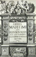 | Details | Morisot, C.B. | 1643 |
| Title Page Orbis Maritimi |
|
Morisot, C.B. |
|
| 1643 |
| LOC:50 |
| $200.00 | Morisot--C-B- | Title-Page-Orbis-Maritimi | Decorative antique title page from the first comprehensive work on maritime history by Charles Barthelemy Morisot (1592-1661) - "Orbis Maritimi siue Rerum".
<br></br>
This rare engraving is adorned with sea shells, anchors, and implements of war. Petrum Palliot, 1643. First and only edition. |