| | Thumbnail | | Creator | Date | Title / Author / Date / Location | Price | | | Description |
| 8064 | 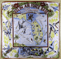 | Details | Anonymous | 1959 |
| Mid century scarf Eglin Air Force Base Florida |
|
Anonymous |
|
| 1959 |
| LOC: |
| $365.00 | Anonymous | Mid-century-scarf-Eglin-Air-Force-Base-Florida | This scarce and colorful mid-20th-century souvenir textile celebrates Eglin Air Force Base, Florida, presenting the installation as a principal proving ground of American air power during the early Cold War. A pictorial map of Florida labeled “Air Proving Ground Command” anchors the design, surrounded by illustrations of jet aircraft, test pilots, target vehicles, and specialized facilities. The textile combines cartographic imagery with promotional aviation art, adapting a souvenir-scarf format widely used for U.S. Air Force bases in the 1950s.<br><br>
The aircraft depicted represent the forefront of U.S. Air Force technology in the supersonic transition era. Shown at mid-left is a B-52 Stratofortress, identifiable by its long straight wings and eight-engine configuration, symbolizing strategic bomber testing. At upper left appears a Lockheed F-104 Starfighter, recognizable by its needle-like fuselage and extremely short wings, while at upper right is a Convair F-102 Delta Dagger, distinguished by its pure delta wing and nose intake. Also depicted is a Republic F-84F Thunderstreak, a swept-wing fighter-bomber widely used in weapons and systems evaluation during the mid-1950s. Additional imagery of test pilots and supersonic tow targets reinforces Eglin’s testing mission.<br><br>
The dating of the textile is supported by both the aircraft selection and the prominent reference to the Climatic Hangar, a facility completed at Eglin in 1954 and widely promoted in subsequent years for extreme-environment testing. The inclusion of the F-102, operational from 1956, and the F-104, which entered U.S. Air Force service in 1958, establishes a firm late-1950s timeframe, while the F-84F reinforces a mid-to-late 1950s context. The absence of later aircraft types or space-age imagery associated with the 1960s further supports an early Cold War date. These elements place the textile most convincingly in the late 1950s, circa 1958 to 1960.<br><br> |
| 8041 | 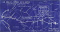 | Details | Hall, Dick Wick | 1920 |
| Rare Salome Road Map by Dick Wick Hall Los Angeles to Phoenix |
|
Hall, Dick Wick |
|
| 1920 |
| LOC:89 |
| $1,450.00 | Hall--Dick-Wick | Rare-Salome-Road-Map-by-Dick-Wick-Hall-Los-Angeles-to-Phoenix | Very rare unrecorded, hand-drawn road map, issued as a blueprint, of central Arizona and California, west of Phoenix by promoter, humorist, publisher, columnist and entrepreneur Dick Wick Hall. Inset note for aviation landing fields, rare on road maps of this era. Hall's initials D.W.H. at bottom right corner.
<br><br>
<div id="0" align="center">
<a title=""></a>
<img id="8041" src="/ZoomifyImages/SC_8041/SC_8041_Frog.jpg" alt="Dick Wick Hall's Famous Salome Frog." width="300"/> <br><br> <font size="-2">Hall's Famous Salome Frog<br> At the Laughing Gas Station. Salome AZ.</font>
</div><br>
Dick Wick Hall founded Salome, Arizona in 1904 as part of a speculative desert development venture along a proposed railroad route in western Arizona. He soon became the town’s most visible booster, operating a roadside service station, promoting travel through the desert, and cultivating a larger-than-life persona that blended entrepreneurship with humor.
<br><br>
Dated to 1920 based on a very similar map published by Hall in his Salome Sun mimeographed newspaper he published between 1920 and 1926. <div class="indenttextblock"><i>" ... the paper was likely intended to be supplied to service stations, such as the one Hall owned in Salome, or other road stops for the traveler passing through, as each issue contains short quips written by Hall about road trips, Yuma County, stories about the desert and driving in the southwest. The paper also often contains cartoonish illustrations of common southwest wildlife, from snakes to scorpions and cacti, as well as regularly featuring a cartoon frog by the name of the Salome Frog who regularly declares that he cannot swim."</i> </div> (Reference: State of Arizona Research Library. Online. https://azmemory.azlibrary.gov/nodes/view/328579).<br><br> |
| 8038 | 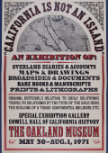 | Details | Anonymous | 1971 |
| Rare California Is Not an Island Oakland Museum Poster |
|
Anonymous |
|
| 1971 |
| LOC:130 |
| $400.00 | Anonymous | Rare-California-Is-Not-an-Island-Oakland-Museum-Poster | An original 1971 exhibition poster “California Is Not an Island,” produced for a special show at the Oakland Museum (Cowell Hall of California History), held May 30 to August 1, 1971. Designed in a bold nineteenth century broadside style with heavy slab-serif lettering in red and black, the sheet advertises an exhibition centered on early documentary materials relating to California’s exploration, overland migration, and Gold Rush-era development. <br><br>At the top is a halftone reproduction of a later embellished edition of Nicolas de Fer's map of California "La Californie ou Nouvelle Caroline", preserving the insular outline and early eighteenth century geographical nomenclature. The reference to Father Eusebio Kino acknowledges the Jesuit explorer whose overland expeditions proved that California was a peninsula, a conclusion directly contradicted by the island form shown here and central to the exhibition’s theme.<br><br>
The body of the poster lists the exhibit’s scope: overland diaries and accounts, maps and drawings, broadsides and documents, rare books, manuscripts, prints, and lithographs. The emphasis on primary sources underscores the museum’s intent to demonstrate how early travelers, scientists, and explorers recorded the region and how these records shaped the narrative of westward movement and the building of the transcontinental railroad. Only two publicly recorded sales of this poster are known.<br><br>
Only two sales of this poster are recorded on the Internet.
<br><br>
The Oakland Museum of California opened during 1969, created from the merger of three older institutions devoted to art, history, and natural science. Housed in a landmark terraced concrete complex by architects Kevin Roche and John Dinkeloo, it was conceived as a new kind of interdisciplinary museum dedicated to the story of California. |
| 8034 | 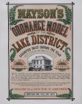 | Details | Mayson, Thomas | 1875 |
| Victorian exhibition advertisement for Mayson’s Relief Ordnance Model |
|
Mayson, Thomas |
|
| 1875 |
| LOC:89 |
| $200.00 | Mayson--Thomas | Victorian-exhibition-advertisement-for-Mayson’s-Relief-Ordnance-Model | Original Victorian exhibition advertisement for Mayson’s 3D Ordnance relief model of the Lake District, Cumbria, North West England, created in 1875 as a major visitor attraction in Keswick. The broadside announces the enormous 210 square foot model exhibited daily at the Lake District Repository on Lake Road, a sculpted landscape built to a scale of six inches to the mile and rendered with exactness from Ordnance Survey data. Bold Victorian lettering, fern motifs, and a vignette of the Repository building frame the promotional text, which highlights mountains, lakes, rivers, waterfalls, villages, and roads shown in full relief and hand colored to nature.
<br><br>
The model was commissioned by Keswick photographer Henry Mayson and his brother Thomas and built by the Italian sculptor Raffaelle Monti and his team using Ordnance Survey sheets as the mathematical basis for every contour. The advertisement stresses its practical value for travelers, noting that the model was an essential tool for planning excursions and understanding the correct topography of the Lake District at a time when tourism was rapidly increasing. Daily opening hours, illumination during summer months, and a one shilling admission charge appear prominently in the lower text block.
<br><br>
As an example of nineteenth century exhibition ephemera, this poster documents one of the most ambitious public relief models ever constructed in Britain and preserves the original marketing for a landmark Lake District attraction. Surviving advertisements for Mayson’s Ordnance Model are scarce, and this sheet stands as a desirable item for collectors of British posters, Lake District history, and early Ordnance Survey derived cartography. |
| 7927 |  | Details | Rambo, Ralph | 1971 |
| Santa Clara Valley sample map letter price list of Ralph Rambo |
|
Rambo, Ralph |
|
| 1971 |
| LOC:41 |
| $325.00 | Rambo--Ralph | Santa-Clara-Valley-sample-map-letter-price-list-of-Ralph-Rambo | A group of three artifacts that capture the spirit of California’s “Valley of Heart’s Delight” as seen through the eyes of Ralph Rambo (1894–1990)—the artist, humorist, and historian who chronicled old Santa Clara before it became Silicon Valley. Included is an autograph letter signed “Ralph Rambo” on his personal printed letterhead, dated circa 1971, in which the 76-year-old Rambo discusses his experience designing and selling maps as a “retirement pastime.” Written in his distinctive hand, the letter reflects his entrepreneurial wit and warm tone as he advises a fellow enthusiast on the economics of map publishing: “You are getting the very last of these maps... a handsome profit in map selling IF you have something GOOD with a wide appeal.”
<br><br>
Accompanying the letter are a salesman's' sample of Rambo’s pictorial map, -- Cartoon Pen and Inklings of the Old Santa Clara Valley — and Rambo's original price list for his illustrated works, all housed together in their original mailing envelope bearing Rambo’s Santa Clara return address. Together these three pieces form an evocative snapshot of a regional artist at work, combining correspondence, cartographic art, and period ephemera. An appealing and uncommon ensemble for collectors of California history, pictorial maps, or mid-century American illustration, they provide a glimpse into Rambo the entrepreneur. |
| 7920 | 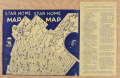 | Details | Motion Picture Industry Guide Service | 1945 |
| Star Home Map Beverly Hills |
|
Motion Picture Industry Guide Service |
|
| 1945 |
| LOC:131 |
| $170.00 | Motion-Picture-Industry-Guide-Service | Star-Home-Map-Beverly-Hills | Printed “Star Home Map” issued by the Motion Picture Industry Guide Service of Beverly Hills, identifying more than one hundred homes of motion-picture stars in Beverly Hills and the western Hollywood Hills. Numbered locations correspond to an index naming Clark Gable, Gary Cooper, Judy Garland, Tyrone Power, Loretta Young, and a young Elizabeth Taylor. Taylor’s inclusion—following her 1944 breakthrough in National Velvet—places this edition around 1944–45.
<br><br>
Printed in blue on yellow stock with whimsical patriotic artwork, the map reflects the early days of Hollywood tourism when visitors sought celebrity homes using printed street guides. An appealing survivor of mid-1940s film-era ephemera that captures the glamour and geography of the movie colony at its wartime peak.
<br><br>
Published by Motion Picture Industry Guide Service, Beverly Hills, California.
Ted Ambrose, Acting Director, Santa Monica Mountains Estate.
Issued under the auspices of I.S.O.M.P.A. (International Screen and Motion Picture Association). |
| 7875 | 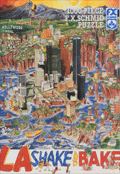 | Details | Holladay, John | 1992 |
| Rare Apocalyptic Los Angeles After Earthquake Puzzle |
|
Holladay, John |
|
| 1992 |
| LOC: |
| $385.00 | Holladay--John | Rare-Apocalyptic-Los-Angeles-After-Earthquake-Puzzle | Scarce and fun 1000 piece pictorial puzzle titled LA Shake and Bake, created in 1992 by illustrator John Holladay and published by F. X. Schmid. Puzzle is unopened in original shrink wrap as issued. <br><br>The puzzle presents a satirical pictorial view of Los Angeles shattered by a massive quake, with districts sliding toward the Pacific Ocean in a dense and humorous cartoon style. The image plays on long standing California earthquake lore. It was also issued by Schmid as an uncut poster. When assembled, the puzzle measures 26.5 by 17.25 inches.<br><br>
Holladay's theme draws on the popular misconception that California might someday break off along the San Andreas Fault, an idea that traces back to public misunderstanding of Andrew Lawson's 1906 report describing lateral motion after the San Francisco earthquake. His phrasing that the Pacific side moved northward relative to the American side echoed for decades, inspiring exaggerated public fears and giving artists like Holladay fertile ground for satirical disaster scenes. The puzzle captures that cultural myth with vivid color and a chaotic, engaging layout.<br><br>
LA Shake and Bake also reflects the long publishing history of F. X. Schmid, founded in Munich in 1860 and best known for toys, cards, and later board games and puzzles. By the 1970s and 1980s the company had expanded internationally, including a U.S. division that produced widely distributed puzzles like this one. Financial pressures in the mid 1990s led to a 1997 merger with Ravensburger, marking the end of Schmid as an independent maker. This puzzle stands as one of the imaginative late period Schmid releases, combining contemporary humor, geological lore, and striking packaging design.
<br><br>
Box size roughly 15.5" x10". |
| 6860 | 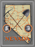 | Details | Anonymous | 1926 |
| Unrecorded Pictorial Map of Nevada and Calendar |
|
Anonymous |
|
| 1926 |
| LOC:89 |
| $350.00 | Anonymous | Unrecorded-Pictorial-Map-of-Nevada-and-Calendar | A very fine pictorial advertising map of Nevada from the Virginia City Bank of Virginia City, Nevada. With a complete calendar for 1926 at bottom. Includes unused metal hanger at top. A rare survivor in excellent condition. Map size 9.5" x 12.5". Overall, about 12" x 23".
<br><br>
<div id="0" align="center">
<a title=""></a>
<img id="6860" src="/ZoomifyImages/SC_6860/SC_6860_detail1.jpg" alt="Unrecorded Pictorial Map of Nevada with Calendar from 1926" width="240"/> <br><br> <font size="-2">1926 Virginia City Bank Advertising Map</font>
</div><br>
Virginia City, Nevada, was a historic mining town that experienced a significant boom in the mid-19th century due to the discovery of the Comstock Lode, a large deposit of silver ore. By 1926, however, the city had long passed its heyday and was in a state of decline. In 1926, the population was estimated to be around 1,500 people, a far cry from the 25,000 residents during the height of the mining boom.
<br><br>
In the early 20th century Virginia City began to shift its focus towards tourism. Efforts were made to embrace, preserve and promote the town's rich mining history and Wild West character to attract visitors. This map reflects that sentiment. |
| 6848 | 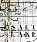 | Details | Utah Railway Chief Engineer | |
| Manuscript engineer's trace |
|
Utah Railway Chief Engineer |
|
|
| LOC:68 |
| $675.00 | Utah-Railway-Chief-Engineer | Manuscript-engineer-s-trace | Singular engineer's presentation trace for the Utah Railway. With this engineer's inked trace map the engineer's office could create numerous blueprint copies for distribution. Produced for the Utah Railway Chief Engineer's office and drawn by Elwood B. Stockman in Feb. 1927. Updated on June 1, 1934. Crisp artwork and lettering. Colors bright.
<br><br>
Shows Salt Lake City with the Salt Lake Base Line at upper left and extends well past Huntington, Utah at bottom right. Shows Park City.
<br><br>
The Utah Railway Company, originally named the Utah Coal Railway, was incorporated on January 24, 1912, and later shortened its name to Utah Railway in May of the same year. The company was founded to transport coal from its mines to Provo, Utah, due to an opening in the competitive landscape caused by dissatisfaction with the existing Denver and Rio Grande Railroad's service and route in the area.
<br><br>
During the 1930s, the Utah Railway faced challenges brought on by the Great Depression, which lowered demand for coal and, consequently, the railroad's business. However, the company managed to maintain its operations and even make some improvements during this difficult period. |
| 6763 |  | Details | National Company | 1949 |
| Map of the World in Azimuthal Projection Centered on Malden Mass USA |
|
National Company |
|
| 1949 |
| LOC:89 |
| $250.00 | National-Company | Map-of-the-World-in-Azimuthal-Projection-Centered-on-Malden-Mass-USA | Scarce "Map of the World in Azimuthal Projection Centered on Malden, Mass USA". Presumed first edition lacking the more elaborate title cartouche found on the 2nd. No copies located in WorldCat.
<br><br>
Malden was home to the National Company, a heavyweight in the manufacturing of radio equipment. The legacy of this enterprise and the town's distinctive place in radio history were immortalized in a unique piece of advertising - this world map centered on this otherwise little-known Massachusetts town.
<br><br>
This ingeniously designed cartographic promotional map was part of a strategy tailored to captivate the attention of amateur radio enthusiasts. It underscored the awe-inspiring power of radio communication, visualizing the potential of the most potent transmitters of the time. One glance at this map made it crystal clear: with the right equipment, you could quite literally tap into the global conversation.
<br><br>
A feature that makes the azimuthal projection stand out among other cartographic methods is its fidelity to directions. Any line drawn from the center point to another location on the map accurately represents the real-world direction. This attribute, where all points appear radially symmetrical around the center, makes it an invaluable tool in aeronautical charts.
<br><br> |
| 6748 |  | Details | Bertuch, Friedrich | 1795 |
| Antique copperplate engraving of Cannabis Sativa or chanvre |
|
Bertuch, Friedrich |
|
| 1795 |
| LOC:87 |
| $500.00 | Bertuch--Friedrich | Antique-copperplate-engraving-of-Cannabis-Sativa-or-chanvre | Antique hand-colored engraved plate ca. 1795 containing early depictions of Cannabis Sativa
( chanvre or hemp). A sub-species of weed, wacky tobakky, boucan, dope, marijuana, grass, reefer, pot, maryjane, ganja, etc. Left-most plant depicted is flax. To the right are male and female specimens of Cannabis Sativa. Scarce.
<br><br>
From Bilderbuch fur Kinder, published from 1792-1830 by Friedrich Justin Bertuch (1727-1822). This encyclopedia was published in 237 parts with 1186 engravings.
<br><br>
Two leaves total. Leaf 1 on wove with images, verso blank. Leaf 2 on laid paper with text descriptions in French and German.
<br><br>
Before you forget, fire up your credit card and score this very rare engraving today. Bhang!
<br><br> |
| 6738 |  | Details | Soule, George | 1859 |
| Very Rare Antebellum New Orleans advertisement Soule Commercial College |
|
Soule, George |
|
| 1859 |
| LOC:150 |
| $6,500.00 | Soule--George | Very-Rare-Antebellum-New-Orleans-advertisement-Soule-Commercial-College | Very rare New Orleans imprint antebellum broadsheet advertisement or "Balance Sheet Circular" produced by George Soule to advertise Soule's Commercial College, established 1856 at the corner of Camp Street and Common Street, in New Orleans, Louisiana. A finely detailed lithograph featuring exquisite calligraphy, numerous inset views of commercial activities, and four example financial statements, including at bottom right, "Statement of Steamer Eclipse Trip No. 8 T.R. Winn Master."
<br><br>
An online search found only one copy of Soule's "Balance Sheet Circular", at the Historic New Orleans Collection.
<br><br>
<div id="6738" align="center">
<a title=""></a>
<img id="6738" src="/ZoomifyImages/SC_6738/SC_6738_400x300.jpg" alt=" Antebellum advertisement for Soule's Commercial College, established 1856 in New Orleans, LA." width="340"/> <br><br> <font size="-2">Soule's Commercial College Balance Sheet Circular</font>
</div><br>
Lithographed by J. Manouvrier. (2) This fine lithograph with beautiful calligraphy was printed in New Orleans in 1859, just after Soule opened the College at Camp and Common Streets. Between 1856 and 1860 Soule's Commercial College graduated a total of more than 275 students. By 1905 the school could boast 1000 students enrolled, 20 teachers, and over 19,000 former students. The school operated in New Orleans continuously, except for a few years during the Civil War, until 1983 when it finally closed.
<br><br>
<div id="6738_2" align="center">
<a title=""></a>
<img id="6738_2" src="/ZoomifyImages/SC_6738/SC_6738_Detail_2.jpg" alt=" Antebellum advertisement for Soule's Commercial College, a view of Jackson Square." width="340"/> <br><br> <font size="-2">Early View of Jackson Square, New Orleans</font>
</div> |
| 6724 |  | Details | Perry, Heather "Herry" | 1930 |
| Rare Art Deco Imperial and International Communications Ltd Map Puzzle |
|
Perry, Heather "Herry" |
|
| 1930 |
| LOC:500 |
| $3,500.00 | Perry--Heather-"Herry" | Rare-Art-Deco-Imperial-and-International-Communications-Ltd-Map-Puzzle | <br></br>Bring a piece of British telecommunications history to your collection. This exquisite, complete, and rare Art Deco style puzzle map of the Imperial and International Communications (IICL) network ca. 1930 precedes McDonald Gill's Cable and Wireless Great Circle map by 15 years and features elegant characters representing the Anemoi, mythological Roman wind gods, and the Greek wind gods or Venti: Boreas, Zephyrus, Notus, Eurus, Aquilo, Favonius, Auster, and Vulturnus. Green lines indicate the undersea cables of the IICL, while dotted green lines signify IICL wireless transmissions.
<br><br>
<div id="0" align="center">
<a title="Perry's Telecom Map Puzzle"></a> <img id="3" src="/zoomifyimages/SC_6724/SC_6724_Detail.jpg" alt="Art Deco details from Herry Perry map puzzle for Imperial and International Communications Ltd, 1930, London." width="350"/> <br><small>Detail from Herry Perry's Art Deco IICL map puzzle, 1930.</small>
</div><br>
The map was designed by Herry Perry and manufactured as a promotional item for the IICL, by the Chad Valley Company, an eminent English toy manufacturer . The Chad Valley Company was active from 1860 to 1978. Its products ranged from high-quality soft toys, educational puzzles, board games, to construction sets.
<br></br>
In 1929, the Imperial Telegraphs Act paved the way for the formation of two new companies that would merge the various telegraph and wireless services within the British Empire and create a coordinated global communications network. Initially, IICL focused on expanding its services within the British Empire, but it eventually expanded its coverage to other regions like the Middle East, Africa, and Asia. IICL merged with Cable & Wireless Limited in 1934. Includes the intact original puzzle box.
<br><br>
Don't miss out on the opportunity to own a rare and remarkable piece of British telecommunications history - purchase this Art Deco map puzzle of the IICL network today. |
| 6559 |  | Details | de Witt, Simeon | 1890 |
| Unusual manuscript trace map of New York state after Simeon de Witt 1802 |
|
de Witt, Simeon |
|
| 1890 |
| LOC:141 |
| $350.00 | de-Witt--Simeon | Unusual-manuscript-trace-map-of-New-York-state-after-Simeon-de-Witt-1802 | One of a kind finely detailed manuscript blue ink trace of sheet 6 from "A Map of State of New York" after Simeon de Witt, 1802. On tracing cloth. This map represents an exceptional effort that likely took days for the anonymous creator to lay down. With a few manuscript notes at bottom right that suggest the trace was created from the copy of de Witt's map held at the New York Public Library (1). Estimated date of creation ca. 1890.
<br><br>
A fine gift for collectors of New York cartography or of rare cartographic oddities.
<br><br>
From an estate with three similar manuscript traced maps of foundational New York State maps by David H. Burr, and <a href="https://www.rarecharts.com/ShowDetail/Creator/Hawkes--W--and-Barber--J-/Title/Manuscript-isodistance-map-of-the-New-York-City-area-after-Hawkes-and-Barber/6560" target="_blank">Hawkes and Barber. </a> Some hydrographic and marshy features in green ink, red ink for roads and highways, brown for political boundaries. Simeon de Witt's original map did not use color to identify these features. At bottom right, in manuscript, a copy of the original title cartouche that was not originally placed on sheet 6, demonstrating the tracer's access to multiple sheets of de Wits map.
<br><br>
(1) Lionel Pincus and Princess Firyal Map Division, The New York Public Library. "Map of the state of New York" The New York Public Library Digital Collections. 1802. https://digitalcollections.nypl.org/items/510d47df-f4d8-a3d9-e040-e00a18064a99 |
| 6560 |  | Details | Hawkes, W. and Barber, J. | 1890 |
| Manuscript isodistance map of the New York City area after Hawkes and Barber |
|
Hawkes, W. and Barber, J. |
|
| 1890 |
| LOC:141 |
| $700.00 | Hawkes--W--and-Barber--J- | Manuscript-isodistance-map-of-the-New-York-City-area-after-Hawkes-and-Barber | Very unusual and one-of-a-kind manuscript traced map ca. 1890 (on tracing cloth) of the area around New York City- after Hawkes and Barber's "The Country twenty five miles round New York" (1777). Text below the map contains a list of important events during the U.S. Revolution in 1776. A key feature of the map is the early use of <b>isodistances</b>, concentric circles at increasing five-mile intervals centered on the city of New York.
<br><br>
This map represents an exceptional effort that likely took days for the anonymous creator to trace. Fine attention to detail and careful execution suggest that the copy was created for research purposes, or possibly for the purpose of producing blueprints from this master trace document. With a few manuscript notes at bottom right that suggest the trace was created from the copy of Hawkes and Barber's map held at the New York Public Library (1).
<br><br>
A fine gift for collectors of New York cartography or of rare cartographic oddities.
<br><br>
From an estate with three similar manuscript trace maps of foundational New York State maps by <a href="https://www.rarecharts.com/ShowDetail/Creator/de-Witt--Simeon/Title/Unusual-manuscript-trace-map-of-New-York-state-after-Simeon-de-Witt-1802/6559"" target="_blank"> Simeon de Witt </a> and David H. Burr. Riverine features in green ink, red ink for highways and roads, brown for political boundaries and for isodistances.
<br><br>
(1) Lionel Pincus and Princess Firyal Map Division, The New York Public Library. "The Country twenty five miles round New York" The New York Public Library Digital Collections. 1777-01-01. https://digitalcollections.nypl.org/items/510d47da-ee36-a3d9-e040-e00a18064a99 |
| 6545 | 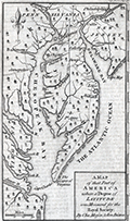 | Details | Mason, Charles and Jeremiah Dixon | 1769 |
| Scarce Chesapeake region map from the survey of Mason and Dixon |
|
Mason, Charles and Jeremiah Dixon |
|
| 1769 |
| LOC:78 |
| $400.00 | Mason--Charles-and-Jeremiah-Dixon | Scarce-Chesapeake-region-map-from-the-survey-of-Mason-and-Dixon | Scarce map of the Chesapeake Bay region with portions of Maryland, Virginia, Delaware, New Jersey and Pennsylvania. The map shows the results of Charles Mason and Jeremiah Dixon's survey of the boundary between the states of Pennsylvania and Maryland. Published in Gentleman's Magazine, 1769.
<br><br>
Surveyors Charles Mason and Jeremiah Dixon spent 58 months establishing the boundaries of Pennsylvania, Maryland, Delaware and West Virginia. The team attained widespread recognition as the creators of the Mason-Dixon Line, the de facto border between the northern and southern United States. Key features include: the Potowmack River, Cape May, Cape Charles, Baltimore, Philadelphia, and Annapolis. Shows several of the key roads in use during the mid 18th-century. |
| 6487 | 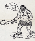 | Details | Anonymous | 1938 |
| Roadside attraction flyer for mythical Hidden City South Dakota |
|
Anonymous |
|
| 1938 |
| LOC:78 |
| $135.00 | Anonymous | Roadside-attraction-flyer-for-mythical-Hidden-City-South-Dakota | Very scarce advertising flyer ca. 1938 with map for the long-forgotten <strong>Hidden City</strong>, a roadside attraction in South Dakota's Black Hills; Admission 25 cents.
<br><br>
<div id="ll" align="center">
<a title="Hidden City, SD"></a>
<img id="ii" src="/ZoomifyImages/SC_6487/SC_6487_DinoSign.jpg" alt="1940s sign for Hidden City Roadside Attraction" width="260"/> <br><small>1940s road sign for Hidden City <br>(not included)</small>
</div><br>
The recto teases "Did Alley Oop ? ? ? ? ? ." "Prehistoric Walls, Cross Walls, Arches and Pavements with Hieroglyphics. Lost City?" and includes a crude drawing of 1930s artist's concept of a caveman, complete with loincloth and club.
<br><br>
</ul>
</div>
<div id="1z" align="center">
<a title="Hidden City, SD"></a>
<img id="3" src="/ZoomifyImages/SC_6487/SC_6487_Detail.jpg" alt="" width="300"/> <br><small>Hidden City, South Dakota Roadside Attraction</small>
</div><br>
Verso with a road map of South Dakota highlighting the location of a number of area attractions, both large and small. The less well-known of these attractions include:
<div class="indenttextblocksingle">
<ul style="list-style-type: circle;"></li>
<li>Black Hills Rock Museum</li>
<li>Black Hills Sugar Factory, Belle Fourche</li>
<li>Stage Barn Caverns</li>
<li>Water Carnival and Race Meet</li>
<li>Nameless Cave</li>
<li>Strato Bowl</li>
</ul>
</div>
Earl Brockelsby, who later started another attraction in 1937, Reptile Gardens, worked as a tour guide at Hidden City. |
| 6393 | 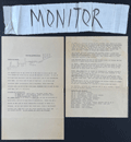 | Details | Anonymous | 1967 |
| San Francisco Protest March map, route instructions and monitors armband. |
|
Anonymous |
|
| 1967 |
| LOC:78 |
| $275.00 | Anonymous | San-Francisco-Protest-March-map--route-instructions-and-monitors-armband- | April 15, 1967 San Francisco, California protest march map, monitor instructions, and a crude cloth armband for a march monitor. Rare.
<br><br>
On April 15, 1967 amidst growing opposition to the U.S. war in Vietnam, large-scale anti-war protests were held in New York, San Francisco, and many other cities.
<br><br>
Numerous "monitor's notes" including:
<br><br>
"So far we have had good relations with the police and we would like to keep it that way".
"Above all -keep cool; <b>the armband as a symbol of authority will handle most situations by itself</b>". |
| 6382 |  | Details | VX9A | 1975 |
| Scarce map of Sable Island, Nova Scotia in the form of a QSL card. |
|
VX9A |
|
| 1975 |
| LOC:78 |
| $150.00 | VX9A | Scarce-map-of-Sable-Island--Nova-Scotia-in-the-form-of-a-QSL-card- | Scarce pictorial map of Sable Island, Nova Scotia, Canada as a QSL card. A QSL card is a written confirmation of two-way radiocommunication between two amateur radio stations, in this case between VX9A on Sable Island and W4UW on the 40 mhz (shortwave band) on November 2, 1975.
<br></br>
On card stock with one vertical and two horizontal folds, as issued. Verso with text and halftone images. |
| 5364 |  | Details | Anonymous | 1909 |
| Pair of manuscript allegorical Maps of the Heart, anatomically correct. |
|
Anonymous |
|
| 1909 |
| LOC:13 |
| $1,100.00 | Anonymous | Pair-of-manuscript-allegorical-Maps-of-the-Heart--anatomically-correct- | Two rare <b>manuscript pen and ink</b> anatomically-correct heart-shaped geographical guides or allegorical maps: "Map of Man's Heart" and "Map of Woman's Heart". Both maps are attributed within circular cartouches reading "Surveyed and Drawn by HUB. Scale 2 miles = 1". 1909." This style of anatomical heart-shaped maps and some of the traits are not found anywhere online.
<br></br>
After similar Victorian-era maps by D.W. Kellogg & Co. of Connecticut ca. 1840. Unlike this manuscript pair of maps, the Kellogg lithographs were based on a stylized and exaggerated bi-lobed conception of the heart- the "Valentine" heart that we know today. Despite the differences in wording of traits, the theme of negative stereotypes for women is the same.
<br></br>
Map of Man's Heart includes large areas devoted to patience, modesty, fidelity (twice), benevolence, humanity, knowledge and love. On the other hand, the Map of Woman's Heart largely features conceit, jealousy, scandal, duplicity, deceit, fickleness and avarice among other traits. The woman's heart is pierced by the "River Tongue" and surrounded on one side by the "kleptomaniac ocean" and on the other side, the "cantankerous ocean".
<br></br>
Seller attributes the provenance to India "it came from a nurses friendship book, she being based in Bangalore India - her name was probably MacDonald." |
| 5351 |  | Details | City of Tarragona | 1833 |
| Very rare antique port pass for Tarragona, Spain wine related with map |
|
City of Tarragona |
|
| 1833 |
| LOC:57 |
| $900.00 | City-of-Tarragona | Very-rare-antique-port-pass-for-Tarragona--Spain-wine-related-with-map | Handsome, finely engraved, signed antique ship's port pass and anchorage plan for the U.S. Brigantine "Hancock" at the port of Tarragona, Spain along the Mediterranean Sea. The port pass, dated within at 1833, includes a large anchorage plan with numerous soundings for the port for Tarragona, with sailing directions in three languages [1] and a description of the ship's cargo of wine and aguardiente. Spanish text.
<br></br>
Rare. No holdings of this item are listed in WorldCat and only one record of a sale of a similar document, from 1820.
<br></br>
Bearing the armorial seal of Tarragona, Spain, the document is topped with a view of the walled city of Tarragona below a Latin scroll touting the safety and health of "Tarraco" [2]. At bottom the signers specify the pass applies specifically to the United States Bergantine (Brig) Hancok (Hancock ?), captained by Ebenezer L. Higgins [3], with a crew of eight sailors. Dated to February 12, 1833 the pass specifies the cargo exported from Tarragona to Brazil consisted of "vino tinto" (red wine), "aguardiente refinado" (brandy) and "aguardiente anisado" (an anise-flavored liqueur popular today in Colombia) [4].
<br></br>
SOURCES:
<br>
[1] "Cape Salou bears from the point of the mole to the So[luth] 5° O. 7 miles distant & Cape Gros or Pointe de la Mora to the east 12° 30' N. 6 1/2 miles distant. The soundings are denoted in Spanish feet of which 35 make 32 English feet." <br>
[2] "Salutem et Sanitatem en Capite insigni Despectans Tarraco Pontum." <br>
[3] Possibly Captain Ebenezer Higgins of Provincetown, Mass. (b. 1807) who died at the helm of the schooner Been Atkins on June 8, 1846 while bound for Norfolk, Virginia. (https://www.findagrave.com/memorial/120392629/ebenezer-higgins) <br>
[4] Colome-Ferrer, Josep and Ferrer, Loren. The importance of the liquor sector in Catalan viticulture in the 18th and 19th centuries. (From Spanish) Journal of Industrial History. No. 79. 2020. |
| 5334 | 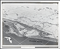 | Details | National Aeronautics and Space Administration | 1966 |
| NASA glossy publicity photo of J . F. K. Space Center map |
|
National Aeronautics and Space Administration |
|
| 1966 |
| LOC:11 |
| $100.00 | National-Aeronautics-and-Space-Administration | NASA-glossy-publicity-photo-of-J---F--K---Space-Center-map | An original NASA unclassified glossy black and white publicity photograph of a NASA birdseye view map of the John F. Kennedy Space Center and the surrounding area in eastern and central Florida. Dated on verso to 8/8/66.
<br></br>
The photograph shows a map, apparently tacked to a bulletin board, ranging in coverage as far as Orlando, Oak Hills, and Eau Galle, Florida. Key points of interest shown include: McCoy Air Force Base, Patrick Air Force Base, Cocoa Beach, the St. Johns River, Indian River, Banana River, and Mosquito Inlet. At the lower left corner is a key or context map showing the location of the map relative to the entire state of Florida.
<br></br>
When the photo was published in August, 1966 NASA was winding down the last two of 19 Gemini program missions to place a capsule with two astronauts into Earth orbit. The final two launches in the Gemini program were:
<br></br>
<div class="indenttextblocksingle">
<ul style="list-style-type: circle;">
<li>Pete Conrad and Richard Gordon. Launched September 12, 1966</li>
<li>Jim Lovell and Buzz Aldrin. Launched November 11, 1966</li>
</ul>
</div> |
| 5300 |  | Details | Liverpool, J. | 1880 |
| Quackery trade card Charlestown map Dr. J. Liverpool, Great Indian Herb Doctor |
|
Liverpool, J. |
|
| 1880 |
| LOC:300 |
| $2,500.00 | Liverpool--J- | Quackery-trade-card-Charlestown-map-Dr--J--Liverpool--Great-Indian-Herb-Doctor | Exceedingly rare and desirable trade card, in the form of a fan, ca. 1880 for Dr. J. Liverpool "The Great Indian Herb Doctor" with a map of Charlestown, Mass. - "Official Plan Battle of Bunker Hill" on verso. An advertisement for quack cures and treatments.
<br></br>
No other example found anywhere on this planet.
<br></br>
Advertising trade card in the form of a octagonal fan, mounted to a handle. <br></br>
Recto: <br></br>
<div class="indenttextblocksingle" style="text-align: center;">
"The Wonder of the World Dr. J. Liverpool Office and Laboratory 81 Green Street Boston, Mass. <br></br>
Where he may be consulted daily free of charge.<br></br>
Office hours 9 a.m. to 9 p.m. <br></br>
Sunday 10 a.m. to 3 p.m. For the benefit of the laboring class. <br></br>
All chronic diseases treated with nature's own remedies, ROOTS, HERBS, BARKS <br>Use no more poisonous drugs.<br></br>
GO AT ONCE AND SEE HIM!<br></br>
Delays are Dangerous.<br></br>
Your disease may be curable to-day - not tomorrow - therefore do not delay. He has cured thousands where others have failed."
<br></br>
</div>
Verso:<br></br>
<div class="indenttextblocksingle" style="text-align: center;">
"Official Plan Battle of Bunker Hill<br></br>
June 17, 1775<br></br>
Manufactured and Printed by L.F. Lawrence & Co.<br></br>
161 & 171 Devonshire and 30 & 32 Arch Streets, BOSTON."
</div>
<br></br>
Note: Dr. Liverpool's address at 81 Green Street, Charlestown, Mass, was one block from Bunker Hill Street and four blocks from the Bunker Hill Monument. Newspaper advertisements in 1882 for Dr. J. Liverpool recorded his address as 833 Tremont Street. |
| 5222 |  | Details | Paine, Howard E. | 1963 |
| Lot of 3 manuscript design options for Round Earth on Flat Paper NGS |
|
Paine, Howard E. |
|
| 1963 |
| LOC:62 |
| $1,200.00 | Paine--Howard-E- | Lot-of-3-manuscript-design-options-for-Round-Earth-on-Flat-Paper-NGS | Three manuscript sketches, design options by Howard Paine (1) for The Round Earth on Flat Paper used on the inside back cover of the National Geographic Society's first Atlas of the World. <i>(National Geographic Society. 1963.)</i>. From the estate of Howard Paine, Art Director at National Geographic until 1990.
<br><br>
Note: The first image of the four displayed, is from the 1963 NGS Atlas and is for comparison only. Not included.
<br><br>
The booklet "The Round Earth on Flat Paper: Map Projections Used by Cartographers" by Wellman Chamberlin was first published by the National Geographic Society in 1947. In 1963 Chamberlin and Paine collaborated on the design of the inside back and front covers for National Geographic's first <b>"Atlas of the World"</b>: <i>The Earth in Space and The Round Earth on Flat Paper</i>. For <i>The Round Earth on Flat Paper</i> Paine sketched several alternate options. The influence of Paine's early designs are evident in the final design selected for the atlas. |
| 5220 |  | Details | Women's Army Corps | 1944 |
| Stand-up Poster for WAC Topographic Draftsman |
|
Women's Army Corps |
|
| 1944 |
| LOC:13 |
| $225.00 | Women-s-Army-Corps | Stand-up-Poster-for-WAC-Topographic-Draftsman | Among the key events impacting the women's movement was World War II. With men away at war, tens of thousands of women entered the workforce to meet the demands of the war for labor. Among the most well-known was "Rosie the Riveter". Here we might have an advertisement to fill the job of "Carrol the Cartographer".
<br></br>
A table-top, stand-up World War II recruitment poster printed on heavy card stock for the Women's Army Corps (WAC) depicting a woman drawing on a map with pencil and protractor. The job specialty promoted is Topographic Draftsman, part of the Army Ground Forces.
<br></br>
With a black ink over-stamp for the U. S. Army Recruiting Station, Room 217 New Post Office Building, Utica N. Y. Illustration is signed but unreadable. |
| 5090 |  | Details | Diamond Match Company | 1942 |
| Galapagos Islands survey by U.S.S. Bowditch match book cover |
|
Diamond Match Company |
|
| 1942 |
| LOC:13 |
| $40.00 | Diamond-Match-Company | Galapagos-Islands-survey-by-U-S-S--Bowditch-match-book-cover | Scarce matchbook cover for the 386-foot U.S. Navy survey vessel U.S.S. Bowditch with an index map for their cruises of 1942-1943 to the Galapagos Islands, a part of Chile. Manufactured by the Diamond Match Company N.Y.C.
<br></br>
The USS Bowditch (AG 30) was first launched in 1929 at Copenhagen, Denmark, as the passenger ship Santa Inez. The Bowditch was outfitted as a surveying vessel and commissioned on 1 July 1940, with Commander E. E. Duval in command.
<br></br>
Departing Norfolk on 9 January 1942, the U.S.S. Bowditch steamed south to conduct surveys of the waters between Panama and Colombia, off the Galápagos Islands, and off the Cocos Islands in Costa Rica.
<br></br>
The following U.S. Navy charts were based on surveys conducted by the U.S.S. Bowditch in 1942 and 1943:
<div class="indenttextblocksingle">
<ul style="list-style-type: circle;">
<li># 5936 Approaches to Bahia Bartago, Archipielago de Colon (Galapagos Islands). 1942.</li>
<li># 5921 Eastern Approaches to Canal de San Salvador, Archipielago Colon (Galapagos Islands). 1943.</li>
<li># 5931 Western approaches to Canal Bolivar, Archipielago de Colon (Galapagos Island). 1942.</li>
<li># 5920 Isle Baltra, Archipielago de Colon (Galapagos Islands). 1942.</li>
<li># 5959: Golfo de Guyaquil. 1943.</li>
</ul>
</div>
The USS Bowditch was decommissioned in January, 1947 |
| 4942 |  | Details | Coronelli, Vincenzo | 1689 |
| Globe Celeste |
|
Coronelli, Vincenzo |
|
| 1689 |
| LOC:62 |
| $650.00 | Coronelli--Vincenzo | Globe-Celeste | A copper-plate engraved view of the Globe Celeste of Vincenzo Maria Coronelli (1650-1718), considered as one of Italy's most famous and greatest cartographers. Coronelli was an Italian Franciscan friar, cartographer, cosmographer and encyclopedist, a trained wood engraver who studied astronomy, Euclidean geometry and ancient philosophy and was named cosmographer for the Republic of Venice.
<br></br>
Coronelli became most famous for his very large globes built in Paris from 1681-1683 at the order of King Louis XIV. His terrestrial and celestial globes measured 3.9 meters in diameter and were not equaled for more than 200 years.
<br></br>
The print, dated within at 1689, celebrates the consecration of the Celestial Globe in 1683 by Cardinal Destrees. Scarce. Only two sales recorded in the AMPR. |
| 4898 |  | Details | International Correspondence Schools | 1949 |
| Radio. Radio. |
|
International Correspondence Schools |
|
| 1949 |
| LOC:41 |
| $100.00 | International-Correspondence-Schools | Radio--Radio- | From "Radio and Electronics: Training for Today's Opportunities". A cover from an early mad-man era brochure that combines the iconography of cartography and of electronics with simple bold graphics to persuade readers to set their lives in a new direction through an electronics training course. Further, the user could fine-tune his education through careful selection of courses. Brochure of 32 pages published by International Correspondence Schools of Scranton, Pennsylvania. Content is careers, benefits, courses and subjects taught. With an inserted application form.
<br></br>
On the face of a what would be a radio dial, the artist has cleverly used familiar compass directions rather than the expected frequency indicators one would see on a radio. Jagged lighting bolts, used instead of rhumb lines, reinforce the impression of the single-word title "Radio". Overall, the message is "Radio and electronics can set your life in a new direction." That is a lot of words to describe what the graphic was intended to convey at a glance.
<br></br>
<div class="indenttextblock">
"... the strength of the ICS system lay in its ability to introduce, in relatively simple language, subjects that its students may have thought were beyond their intellectual reach and then build gradually to mastery of fields like electrical or chemical engineering. In essence, ICS and other correspondence schools attempted to demystify industrial technology and science, to bring them down from their pedestals at the same time that Americans were barraged by and frightened by technological advances and yearned to understand and embrace them."(Watkinson, James D. Education for Success: The International Correspondence Schools of Scranton, Pennsylvania. Penn. Mag of History and Biography. Vol CXX No. 4. October, 1996. P. 364.)
</div> |
| 4870 |  | Details | U.S. Navy Office of Naval Research | 1944 |
| WWII three-dimensional weather map training simulator. |
|
U.S. Navy Office of Naval Research |
|
| 1944 |
| LOC:0 |
| $300.00 | U-S--Navy-Office-of-Naval-Research | WWII-three-dimensional-weather-map-training-simulator- | From the U.S. Navy Office of Naval Research Special Devices Center, a set of three, three-dimensional pilot training weather simulators (Device 12-K-2a) produced during WWII. This device is noteworthy for its connection to Rear Admiral Luis de Florez (1889-1962) who established the Special Devices Desk at the U.S. Navy during WWII.
<br></br>
De Florez, an MIT graduate, was inducted into the Hall of Fame by the National Center for Simulation in 2014.
<div class="indenttextblocksingle">
"As both an active duty and a retired U.S. Navy Admiral, de Florez was influential in the development of early flight simulators, and was a pioneer in the use of virtual reality to simulate flight and combat situations in World War II."
<br></br>
"In 1941 ... Commander de Florez became head of the new Special Devices Desk in the Engineering Division of the Navy’s Bureau of Aeronautics. De Florez championed the use of synthetic training devices and urged the Navy to undertake development of such devices to increase readiness."
<br></br>
During World War II, he was subsequently promoted to captain and then to Flag rank, becoming a rear admiral in 1944.In 1944, de Florez was awarded the Robert J. Collier Trophy for 1943 for his work in training combat pilots and flight crews through the development of inexpensive synthetic devices. (https://www.simulationinformation.com/hall-of-fame/members/luis-de-florez)
</div>
<BR />
Set of 3 folding weather map models on heavy card stock that present a three-dimensional view of typical cyclonic storms:
<div class="indenttextblocksingle">
<ul style="list-style-type: circle;">
<li>Map 1. Early Stage of Development</li>
<li>Map 2. Cold-Front type occlusion</li>
<li>Map 3. Warm front type occlusion</li>
</ul></div>
Each model depicts a single storm through a series of eight slices or sections representing storm development across a front of 800 miles and a depth of 1000 miles at a single point in time. |
| 4862 |  | Details | Foreman, D. H. | 1916 |
| Antique Plans Hidden Treasure Mine Lake City, Colorado |
|
Foreman, D. H. |
|
| 1916 |
| LOC:0 |
| $3,250.00 | Foreman--D--H- | Antique-Plans-Hidden-Treasure-Mine-Lake-City--Colorado | The most interesting set of gold mining plans I have seen!
<br><br>
A very absorbing pair of fine antique presentation plans for the Hidden Treasure Mine at Lake City, in Hinsdale County, Colorado between Crystal Creek and Ute Creek. The Hidden Treasure Mine (1897-1922) was a gold, silver, lead, and copper mine located at an elevation of 10,200 feet.
<br><br>
Both plans are hand-colored blue-line artifacts on architectural vellum.
<b>Plan 1 includes:</b>
<div class="indenttextblocksingle">
<ul style="list-style-type: circle;">
<li>Fig 1. Plan Map of the Hidden Treasure Property</li>
<li>Fig 2. Longitudinal Section of Slope of Vein Looking West.</li>
<li>Fig 3. Plan of Underground Workings.</li>
</ul>
</div>
<b>Plan 2 includes:</b>
<div class="indenttextblocksingle">
<ul style="list-style-type: circle;">
<li>Fig 4. Longitudinal Section Underground Workings. Looking West.</li>
<li>Fig 5. Cross-section Through "X-Y" (Plate 1) Looking S.W.</li>
<li>Sampling data and ore valuation table.</li>
</ul>
</div>
Dated within to 12/20/16. Drawn by D.H. Foreman, Denver, Colorado.
<br></br>
The old Hidden Treasure Dam on Henson Creek, built in the 1890's, made the news in late May, 2019. It was announced that the dam was to be demolished because of the concern for flash floods associated with the potential for sudden heavy snowmelt. (Source: https://www.cpr.org/news/story/historic-hidden-treasure-dam-is-coming-down-to-ease-the-flood-threat-to-lake-city)
<br></br>
On Fig 1. Plan Map of the Hidden Treasure Property two tunnels are shown leading to the Lower Terminal Mill. More than 100 years old, the Hard Tack Mine tunnel was built as an underground transport tunnel for the Hidden Treasure Mining Company's ore production one quarter mile up the mountain (shown here as "proposed"). The Hardtack Mine now (2024) houses a museum designed to preserve area mining history and offers tours June to September. |
| 4853 | 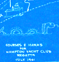 | Details | Hampton Yacht Club | 1941 |
| Hampton Yacht Club Regatta Cyanotype Map |
|
Hampton Yacht Club |
|
| 1941 |
| LOC:13 |
| $250.00 | Hampton-Yacht-Club | Hampton-Yacht-Club-Regatta-Cyanotype-Map | Unusual self-published cyanotype (blueprint) course map of the Hampton Yacht Club 14th Annual Regatta July 5 and 6 at Hampton, Virginia, complete with a sketch of an undulating sea serpent (rarely found on a cyanotype) and another small cartoon at the Hampton Bar. The course chart shows the coast outline with the offshore one-fathom line and the beacons and buoys marking the course.
<br></br>
This pre-war cartographic artifact is sold with two included documents:
<div class="indenttextblocksingle">
<ul style="list-style-type: circle;">
<li>A printed summary of the Regatta's sailing event with notes on prizes, courses, starting signals, rules for resolving protests, and a schedule of sailing events. For a map of the course the summary states: "See chart no. 400 and blueprint copies of part of the same which will be available at the clubhouse."</li>
<li> A one-page type-written set of Racing Rules for Warwick One Design Dinghies.</li>
</ul>
</div>Top left corner "H.K.S. 7/3/41" |
| 4806 |  | Details | Wilcox and Follett Co. | 1944 |
| Advertisement for Octovue Map on Pitner's Projection |
|
Wilcox and Follett Co. |
|
| 1944 |
| LOC:88 |
| $350.00 | Wilcox-and-Follett-Co- | Advertisement-for-Octovue-Map-on-Pitner-s-Projection | Scarce color brochure from 1944 explains and promotes Wilcox and Follet Co's Octovue map, their <b>New Air Age Educational -- Indispensable! WORLD MAP.</b> All on one single folding sheet printed front and back with 8 pages total in color. Folded size 5" x 8".
<br></br>
The Octovue map was one of the few maps to use the Pitner map projection. According to this brochure with the Pitner projection:
<div class="indenttextblock">
"The globe is divided into eight uniform spherical triangular sections: four North and four South of the equator…. each transposed onto a flat surface. … the first map ever made to transpose the round world onto a flat sheet without distortion or exaggeration of shapes, sizes, and distances."
</div>
<br></br>
Last page details what the U.S. Coast and Geodetic Survey in <i>Elements of Map Projections</i> consider to be the "Ideal Map" and provides reasoning for consideration of the Octovue map over all others.
<br></br>
Copyright 1944 by L.E. Pitner. Brochure edited by Harold B. Ward Ph.D. F.R.G.S. |
| 5194 |  | Details | Pitner, L. E. | 1944 |
| Illustrated Octovue Map on Pitner's Projection |
|
Pitner, L. E. |
|
| 1944 |
| LOC:53 |
| $350.00 | Pitner--L--E- | Illustrated-Octovue-Map-on-Pitner-s-Projection | Rare and unusual world map on the Pitner projection. First edition. Illustrated with hundreds of small drawings of flora, fauna, native tribes, buildings, transportation and landmarks. With 5 inset maps on the Mercator and other more common projections. Card covers with map still attached.
<br></br>
The Illustrated World Octovue Projection Edited by Harold B. Ward Ph. D. F.R.G.S. Designed and Published by L.E. Pitner 229 W. Mineral Street, Milwaukee, Wis. Copyright November 3, 1944 by L.E. Pitner
The Octovue map was one of the few maps to use the Pitner map projection. The Pitner projection is explained as:
<div class="indenttextblocksingle">
"The globe is divided into eight uniform spherical triangular sections: four North and four South of the equator…. each transposed onto a flat surface. … the first map ever made to transpose the round world onto a flat sheet without distortion or exaggeration of shapes, sizes, and distances."
</div>
An earlier version of the Pitner projection map was published in 1943 on a single-sided sheet as the "Air Age Octovue Map of the World". Again edited by Ward with a 1943 copyright by Pitner. That version of the map lacks the illustrations and some of the map elements from the verso of our map are on the recto of the 1943 version.
<br></br>
The Pitner projection was similar to the Lambert Azimuthal Equal-area projection.
<br></br> |
| 4706 | 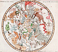 | Details | Fortin, J. | 1775 |
| Antique star chart of the Southern Hemisphere after Lacaille |
|
Fortin, J. |
|
| 1775 |
| LOC:13 |
| $280.00 | Fortin--J- | Antique-star-chart-of-the-Southern-Hemisphere-after-Lacaille | Fine decorative antique hand-colored engraved celestial star chart for the Southern Hemisphere from the Atlas Céleste de Flamstéed, updated and reduced by J. Fortin in 1776. This map of the Southern skies is based on Nicolas Louis de Lacaille’s star chart from 1754 in which Lacaille included 14 new constellations.
<br></br>
Lacaille sailed to South Africa in 1750 where he set up a small observatory at the Cape of Good Hope under the famous Table Mountain, which impressed him so much that he later named a constellation after it, Mensa. At the Cape in 1751 - 52 Lacaille observed the positions of nearly 10,000 stars. On his return to France in 1754, Lacaille presented a map of the southern skies to the French Royal Academy of Sciences which included 14 new constellations of his own invention. An engraved version of his celestial map was published in the Academy’s Mémoires in 1756 and Lacaille’s new constellations were rapidly accepted by other astronomers.
<br></br>
Flamsteed was born into a prosperous family & was largely self taught as he did not attend University due to poor health. He was appointed the first Astronomer Royal by King Charles II, with the Royal Observatory at Greenwich being built for him to continue his astronomical observations. Flamsteed's Celestial Atlas was first published ten years posthumously by his wife in 1729. It set the standard in professional astronomy for almost a century, with the positions of over 3,000 stars given more accurately than ever before.
<br></br>
French text for names of stars and constellations. Page 29. Lettered by Beauble' ; engraved by C.E. Voisard. |
| 1457 | 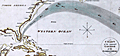 | Details | Gold, Joyce | 1804 |
| Chart of the Supposed Course of the Florida Stream |
|
Gold, Joyce |
|
| 1804 |
| LOC:3 |
| $400.00 | Gold--Joyce | Chart-of-the-Supposed-Course-of-the-Florida-Stream | Graphically arresting thematic chart of the "Florida Stream" or Gulf Stream with its flow northwards up the east coast of the United States, well past Bermuda, and then into the North Atlantic Ocean. Direction of the Gulf Stream current is shown visually by arrows supplemented with written notations indicating the compass direction at several locations across the stream.
<br></br>
The map may be considered to be an example of persuasive cartography. The concept of the Gulf Stream was novel at that time (hence the "supposed"); many mariners had not fully adopted the notion when this map was published. The direction and flow of the Gulf Stream was proposed by Benjamin Franklin in 1770 based on measurements he took during voyages from the U.S. to England and France.
<br></br>
London Published May 31, 1804 by J. Gold, 103 Shoe Lane. |
| 1379 | 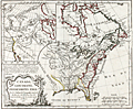 | Details | Vaugondy, Robert de | 1778 |
| Fine Antique Speculative Map of North America |
|
Vaugondy, Robert de |
|
| 1778 |
| LOC:10 |
| $350.00 | Vaugondy--Robert-de | Fine-Antique-Speculative-Map-of-North-America | A good example of Robert de Vaugondy's 1778 map of North America's English Possessions incorporating his speculative geography of the American northwest. The map covers from Hudson Bay to the Gulf of Mexico and from the Atlantic Ocean to Texas, then "Nouveau Mexique".
<br></br>
This map's most interesting features are in the large inset in the upper left quadrant illustrating Vaugondy's speculative geography of the American Northwest. The map features the Sea of the West (Mer de L'Ouest), the discoveries of Admiral de Fonte, the discoveries of Bernarda, the Strait of Anian, and the mythical kingdoms of Quivira and Teguaio.
<br></br>
There is no reliable evidence to authenticate either the existence of Admiral de Fonte himself or of the voyage. The account of de Fonte's voyage, first published in 1708, took the form of a letter by de Fonte in which he described himself as “then Admiral of New Spain and Peru, and now Prince of Chili.” The story is now attributed to the editor of the London Magazine.
<br></br>
Perhaps Vaugondy was attempting a bit of "fake news" and trying to muddy the waters over the English claims to North American territory by including these speculative geographic features into the map.
<br></br>
From Vaugondy's "Nouvel atlas portatif ". Engraved by Dussy. |