| | Thumbnail | | Creator | Date | Title / Author / Date / Location | Price | | | Description |
| 1355 | 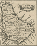 | Details | Popple, Henry | 1742 |
| Antique maps of the islands of Barbados and Antigua. |
|
Popple, Henry |
|
| 1742 |
| LOC:0 |
| $0.00 | Popple--Henry | Antique-maps-of-the-islands-of-Barbados-and-Antigua- | SOLD
<br></br>
Two small scarce antique copper-plate engraved maps of the islands <b>Barbados and Antigua</b> in the Caribbean Sea. These two neat maps, are after Henry Popple (1733). Popple's charts predate the later charts of Bellin and Bowen who based their geography on Durrell. Popple's map was titled: "A Map of the British Empire in America with the French, Spanish and the Dutch Settlements adjacent thereto".
<br></br>
This fragment was originally part of a sheet published by Covens and Mortier in 1742 in "Les Principales Forteresses Ports etc. de L'Amerique Septentrionale"; a larger engraved sheet containing harbor and island maps and plans of the Americas. The maps were trimmed from the larger sheet originally containing the two as shown.
<br></br>
Covens and Mortier published that single sheet of 18 maps and plans of islands and harbors in order to replace Popple's original large map of 20 sheets with a more manageable six-sheet version. |