| | Thumbnail | | Creator | Date | Title / Author / Date / Location | Price | | | Description |
| 1336 | 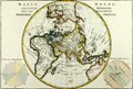 | Details | Bonne, Rigobert | 1787 |
| Eastern Hemisphere - Antique 45 Degree Northern Oblique Projection |
|
Bonne, Rigobert |
|
| 1787 |
| LOC:9 |
| $245.00 | Bonne--Rigobert | Eastern-Hemisphere---Antique-45-Degree-Northern-Oblique-Projection | Early antique projection covering the Eastern Hemisphere taken from 45 degrees north latitude. Includes the North Pole, northern North America with Alaska; Africa, Madagascar, Europe, Japan, western Australia (Nouvelle Hollande"), and New Zealand. A very fine copper-plate engraved map produced by Rigobert Bonne and crisply and finely engraved by Andre to include mountain ranges and numerous place names. Includes two related views on the plate including one colorful view of the "Sphere Oblique" and another obtuse drawing labeled "Effet de Pesanteur".
<br></br>
Rigobert Bonne (1727-1794) was the successor to Jacques Nicolas Bellin as Royal Cartographer to France in the office of the Hydrographer at the Depôt de la Marine. Bonne first came to prominence when he published a number of charts in the Atlas Maritime in 1762, but Bonne is better known for later publications, including the Atlas Encyclopedique, which he collaborated on with Nicholas Desmarest, as well as the maps he produced for Raynal's Atlas de Toutes Les Parties Connues du Globe Terrestre. Published in Paris in 1787. Plate 24. |
| 1414 | 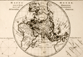 | Details | Bonne, Rigobert | 1787 |
| Northern Oblique Projection of eastern Hemisphere or Hemisphere Oriental. |
|
Bonne, Rigobert |
|
| 1787 |
| LOC:0 |
| $0.00 | Bonne--Rigobert | Northern-Oblique-Projection-of-eastern-Hemisphere-or-Hemisphere-Oriental- | SOLD<br></br>
Early antique projection covering the Eastern Hemisphere or "Hemisphere Oriental" taken from 45 degrees north latitude. Includes the North Pole, northern North America with Alaska; Africa, Madagascar, Europe, Japan, western Australia (Nouvelle Hollande"), and New Zealand. A very fine copper-plate engraved map produced by Rigobert Bonne and crisply and finely engraved by Andre to include mountain ranges and numerous place names. Includes two related views on the plate including one colorful view of the "Sphere Oblique" and another obtuse drawing labeled "Effet de Pesanteur".
<br></br>
Rigobert Bonne (1727-1794) was the successor to Jacques Nicolas Bellin as Royal Cartographer to France in the office of the Hydrographer at the Depôt de la Marine. Bonne first came to prominence when he published a number of charts in the Atlas Maritime in 1762, but Bonne is better known for later publications, including the Atlas Encyclopedique, which he collaborated on with Nicholas Desmarest, as well as the maps he produced for Raynal's Atlas de Toutes Les Parties Connues du Globe Terrestre. Published in Paris in 1787. Plate 24. |
| 738 | 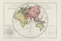 | Details | Bonne, Rigobert | 1787 |
| Antique World Map of the Eastern Hemisphere including Australia |
|
Bonne, Rigobert |
|
| 1787 |
| LOC:0 |
| $0.00 | Bonne--Rigobert | Antique-World-Map-of-the-Eastern-Hemisphere-including-Australia | SOLD<br></br>
Antique French map of the Eastern Hemisphere by cartographer Rigobert Bonne from Paris. Key features include a misshapen, elongated Australian continent, and Africa, China, and Europe. Significantly, no land mass is shown south of the Antarctic circle as the first sighting of land below 60 degrees south latitude did not occur until 1820.
<br></br>
The copper-plate engraving includes a very decorative compass rose: "Rose de Boussole avec les noms des Vents en usage sur le Ocean.", at left with all 32 compass points attributed to their named winds in the Ocean Sea (e.g., Nord, Sud, Est, Ouest, etc.)
<br></br>
Rigobert Bonne was the successor to Jacques Nicolas Bellin as Royal Cartographer to France in the office of the Hydrographer at the Depôt de la Marine. This engraved 18th-century plate was published in 1787 in Bonne's ATLAS ENCYCLOPEDIQUE CONTENANT LA GEOGRAPHIA ANCIENNE, ET QUELQUES CARTES SUR LA GEOGRAPHIE DU MOYEN AGE, LA GEOGRAPHIE MODERNE, ET LES CARTES RELATIVES A LA GEOGRAPHIE PHISIQUE…. . Plate 20. |
| 1409 | 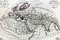 | Details | Lapie, Pierre | 1816 |
| Antique map of Asia |
|
Lapie, Pierre |
|
| 1816 |
| LOC:6 |
| $120.00 | Lapie--Pierre | Antique-map-of-Asia | Very nice antique map of the eastern hemisphere or the entire world as it was known to exist in ancient times. Notations on the map reference Pliny, Ptolemy, Eratosthenes and other very early Greek historians and geographers. Includes north Africa, Mediterranean Sea, India, Europe, Arabia,and western Asia. Upper left corner contains diagram with names of the winds.
<br></br>
Pierre M. Lapie (1779-1850), a Colonel in the French army, was a French cartographer and engraver. Lapie worked in the corps of topographical engineers. Pierre was the father of cartographer Alexandre Emile Lapie. In the first half of the 19th century, the work of the Lapie firm, with its precise engraving and informational density, strongly influenced their German competitors whose maps would eventually dominate the continental European market. |