| | Thumbnail | | Creator | Date | Title / Author / Date / Location | Price | | | Description |
| 4822 | 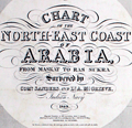 | Details | British Admiralty Hydrographical Office | 1912 |
| Antique nautical chart of Arabia from Muscat to Ras Sukra, Oman |
|
British Admiralty Hydrographical Office |
|
| 1912 |
| LOC:54 |
| $3,750.00 | British-Admiralty-Hydrographical-Office | Antique-nautical-chart-of-Arabia-from-Muscat-to-Ras-Sukra--Oman | Chart of Oman on the eastern Arabian coast by Commander J.P. Sanders and Lieutenant Albany Grieve of the <b>Indian Navy</b> aboard the ship <b>Palinurus</b>. The survey was significant in that it resulted in connecting the surveys of the Persian Gulf to the surveys of the Red Sea.
<div class="indenttextblocksingle">
"… and thus the coastline, from Cape Comorin to Ras Gulwainee on the African continent, had been minutely examined and laid down by the officers of the Indian Navy." [1]
</div>
</br>
Includes 6 inset port and harbor charts from other British surveys as well as surveys of the French Government:
<div class="indenttextblocksingle">
<ul style="list-style-type: circle;">
<li>Bandar Jissa</li>
<li>Sur Anchorage</li>
<li>Bandar Khairan</li>
<li>Madraka Anchorage</li>
<li>Khor Jarama</li>
<li>Dar Sait Anchorage</li>
</ul>
</div>
</div>
[1] Low, Charles Rathbone. History of the Indian Navy (1613-1863). V2. London, 1877. p. 215.
</div> |
| 5080 | 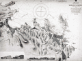 | Details | British Admiralty Hydrographical Office | 1918 |
| Oman Maskat and Al Matrah surveyed by Lieut A.W. Stiffe |
|
British Admiralty Hydrographical Office |
|
| 1918 |
| LOC:66 |
| $2,500.00 | British-Admiralty-Hydrographical-Office | Oman-Maskat-and-Al-Matrah-surveyed-by-Lieut-A-W--Stiffe | Scarce and truly fascinating British Admiralty chart of the coast of Oman showing Matrah (Mutrah) Bay and Maskat Cove with a plan of the town of Maskat, now Muscat the port capital of Oman. Includes two fine inset elevation views: View of Maskat from the Cove and a view of the larger area from Ras Maskat to Doha. Only one sale of the chart is recorded in the Antique Map Price Record- by the esteemed dealer Jonathan Potter in 1985 (those were the days).
<br></br>
Published first by the Admiralty May 27, 1862 under the superintendence of Rear Admiral Washington, Hydrographer. This is the edition of 1917 with last correction in 1918. Engraved by J. & C. Walker.
<br></br>
Just a few of the interesting features captured by this chart include:
<div class="indenttextblocksingle">
<ul style="list-style-type: circle;">
<li>The Sultan's Palace.</li>
<li>"Mass of rugged hills culminating in the Saddle 3 miles to the Southward."</li>
<li>A pass through the rugged terrain "for foot passengers and unloaded animals."</li>
<li>The city gate with an auction bazaar just outside the walls.</li>
<li>Telegraph office.</li>
<li>British Consulate.</li>
</ul>
</div>
Chart number 2869. |