| | Thumbnail | | Creator | Date | Title / Author / Date / Location | Price | | | Description |
| 1332 | 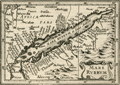 | Details | Bertius, Petrus | 1609 |
| Antique map of the Red Sea and Arabia |
|
Bertius, Petrus |
|
| 1609 |
| LOC:0 |
| $0.00 | Bertius--Petrus | Antique-map-of-the-Red-Sea-and-Arabia | SOLD<br></br>Fine small antique map of the Red Sea, Saudi Arabia, Aden, Yemen,and Egypt. This attractive copperplate engraved map covers numerous islands and villages including Aden, Suez, Mecca (Mecha), and Medina. By Petrus Bertius ca 1609. Text on verso is in French. |
| 1118 | 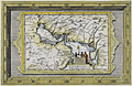 | Details | Aa, Pieter van der | 1713 |
| Antique Dutch Map of the Persian Gulf region |
|
Aa, Pieter van der |
|
| 1713 |
| LOC:0 |
| $0.00 | Aa--Pieter-van-der | Antique-Dutch-Map-of-the-Persian-Gulf-region | SOLD<br></br>
Beautiful intaglio-printed antique map by Peter van der Aa of the Persian Gulf region incorporating portions of present-day Saudi Arabia, Iran, Iraq, India, Bahrain ("Baharem"), Qatar ("Queximi"), Oman, Ormuz, and Kuwait. Key cities va der AA identified by name include: Mecca ("Mecha") , Medina ("Medina t Alnabi"), Basrah ("Bassora"), Muscat ("Mascate"), Ahmedabad ("Hamedebat"), and Khambhat ("Cambaya").
<br></br>
This fine map will make a handsome presentation when framed. An attractive cartouche with European ships in the background shows a local merchant negotiating with two dark, shirtless natives carrying a spear.
<br></br>
Pieter van der Aa (1659 - 1733) was a Dutch publisher working in Leiden during the early eighteenth century. He is best known for publishing maps and atlases, though he also printed pirated editions of foreign bestsellers and illustrated volumes. Van de AA's use of stock mock-frame borders is a characteristic for which he is well known. This map shows evidence of two plate marks, one for the mock-frame and the second interior platemark for the smaller map which was printed inside the mock-frame. From "Le nouveau theatre du monde. ou La geographie royale, composée de nouvelles cartes tres-exactes", published from Leiden in 1713. |
| 5460 | 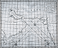 | Details | Cutler and Halley | 1728 |
| A Chart of the East Indian Ocean from Cape Guardefoy to Cochin or the Coast of Malabar |
|
Cutler and Halley |
|
| 1728 |
| LOC:64 |
| $1,650.00 | Cutler-and-Halley | A-Chart-of-the-East-Indian-Ocean-from-Cape-Guardefoy-to-Cochin-or-the-Coast-of-Malabar | Rare antique chart from 1728 of the Persian Gulf and Gulf of Oman on a <b>globular projection</b> by scientists <b>Nathaniel Cutler and Edmund Halley</b> (the latter was the discoverer of Halley's comet). Shows Saudi Arabia, Yemen, West India, Iran, the Indian Ocean, and much more with detailed notations of habitations along the coast.
<br></br>
From "Atlas Maritimus & Commercialis, or a General View of the World, so Far as Relates to Trade and Navigation …". The sea atlas "Atlas Maritimus" was a collaborative effort of a number of the leading cartographic and scientific names of the era, including English astronomer Sir Edmund Halley, John Senex, Nathaniel Cutler, and Daniel Defoe. The atlas was developed by publishers Senex and Harris to compete with Mount & Page’s English Pilot. Published from London: James and John Knapton et al. |
| 3633 | 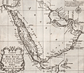 | Details | Bellin, Jacques Nicolas | 1740 |
| Nice French antique map of Saudi Arabia, Red Sea, Persian Gulf |
|
Bellin, Jacques Nicolas |
|
| 1740 |
| LOC:6 |
| $320.00 | Bellin--Jacques-Nicolas | Nice-French-antique-map-of-Saudi-Arabia--Red-Sea--Persian-Gulf | Striking and beautifully engraved map of Arabia, the Red Sea, and the Persian Gulf. Decorative compass rose and scroll-work title cartouche. The area shown on this fine original map is currently territory of these states: Saudi Arabia, Egypt, Israel, Jordan, Iraq, Iran, United Arab Emirates, Yemen, Oman and more.
<br></br>
Published by Jacques Bellin by order of the Count de Maurepas (Jean-Frédéric Phélypeaux 1701-1781) who served as France's Minister of Marine from 1723-1749. By his recommendations to Louis XVI delaying economic and administrative reforms, Maurepas was partially responsible for the governmental crises that led to the French Revolution.
<br></br>
French hydrographer Jacques Nicolas Bellin (1703-1772) was born in Paris and educated as an engineer. In 1741, Bellin became the first Ingénieur de la Marine of the Depot des cartes et plans de la Marine (the French Hydrographical Office) and was named Official Hydrographer of the French King. Bellin's largest and most comprehensive work is the Petit Atlas Maritime that covered the coasts and important port cities of the known world. |
| 1249 | 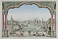 | Details | Anonymous | 1750 |
| Jeddah, Saudi Arabia antique vue d'optique |
|
Anonymous |
|
| 1750 |
| LOC:0 |
| $0.00 | Anonymous | Jeddah--Saudi-Arabia-antique-vue-d-optique | SOLD
<br></br>
Antique optical print or vue d'optique of Jeddah, Saudi Arabia the port for Mecca or Lamekk (la Mecque) ca 1750. This attractive engraved print is one of the earliest available views of Jeddah, an important trading port city on the Red Sea coast of Saudi Arabia.
<br></br>
With a population currently at 4.2 million people, Jeddah is the largest city in Makkah Province, the largest sea port on the Red Sea, and the second-largest city in Saudi Arabia. |
| 5192 | 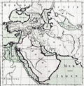 | Details | de Mornas, Buy | 1762 |
| Empire de Cyrus |
|
de Mornas, Buy |
|
| 1762 |
| LOC:66 |
| $325.00 | de-Mornas--Buy | Empire-de-Cyrus | Fine original antique engraved map of the empire of Cyrus the Great of Persia. "Empire de Cyrus", was taken from the <b>Atlas Historique et Géographique</b> by de Mornas. The map encompasses much of western Asia and the Middle East including Saudi Arabia and Iran. Very decorative border. |
| 1207 | 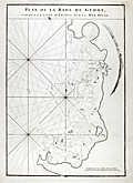 | Details | Mannevillette, d'Apres | 1775 |
| Early chart of Jeddah, Saudi Arabia |
|
Mannevillette, d'Apres |
|
| 1775 |
| LOC:0 |
| $0.00 | Mannevillette--d-Apres | Early-chart-of-Jeddah--Saudi-Arabia | <b>SOLD</b>, but see <a href="https://www.rarecharts.com/ShowDetail/Creator/Mannevillette--d-Apres/Title/Antique-chart-of-Jeddah-Gedda-Saudi-Arabia/4828" target="_blank">another example</a> now in stock.
<br></br>
Early French nautical chart of the anchorage of Jeddah, Saudi Arabia on the Red Sea. Shows the passage into the port of "Gedda" with a defensive wall. Curved elevation view of the coastline near Jeddah, Saudi Arabia. |
| 5336 | 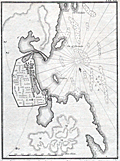 | Details | Niebuhr, Carsten | 1775 |
| Antique plan of the port of Jeddah Saudi Arabia |
|
Niebuhr, Carsten |
|
| 1775 |
| LOC: |
| $375.00 | Niebuhr--Carsten | Antique-plan-of-the-port-of-Jeddah-Saudi-Arabia | Very scarce antique copper engraving of the port and city of <b>Jeddah (Dsjidda), Saudi Arabia.</b> The plan is after the travels to the Middle East and India of German explorer Carsten Niebuhr. Niebuhr himself conducted the survey of Jeddah of which this is a record. The plan of Jeddah has both topographic and hydrographic details with numerous soundings and sandbanks reflecting an extensive, time-consuming survey of the port and harbor of Jeddah. North oriented to bottom right.
<br></br>
With a population currently estimated at 4.2 million persons, Jeddah is the largest city in Makkah Province, the largest sea port on the Red Sea, and the second-largest city in Saudi Arabia.
<br></br>
<b>Carsten Niebuhr</b> (1733-1815), a military surveyor, was the only survivor of the six-member Royal Danish Expedition to Arabia that departed the city of Copenhagen in 1761 at the request of Danish King Frederick V. In addition to Jeddah the expedition visited Istanbul, Cairo, Bombay, Basra, Baghdad, Aleppo, Mokka, Alexandria and other middle eastern sites. Returning alone to Copenhagen in November 1767, Niebuhr spent the next few years writing an extensive account of the expedition's travels in four volumes including <i>Beschreibung von Arabien</i> in 1772.
Plate 18. |
| 4828 | 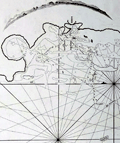 | Details | Mannevillette, d'Apres | 1775 |
| Antique chart of Jeddah Gedda Saudi Arabia |
|
Mannevillette, d'Apres |
|
| 1775 |
| LOC:88 |
| $900.00 | Mannevillette--d-Apres | Antique-chart-of-Jeddah-Gedda-Saudi-Arabia | Rare. Early French nautical chart of the anchorage of Jeddah, Saudi Arabia on the Red Sea. Shows the passage into the port of "Gedda" with a defensive wall. Curved elevation view of the coastline near Jeddah, Saudi Arabia.
<br></br>
From J. B. d'Apres de Mannevillette's sea atlas "Le Neptune Oriental ou routier general des Cotes des Indes orientales et de la Chine." Jean-Baptiste d'Après de Mannevillette (1707 - 1780) was a French sailor, navigator, and hydrographer active in the mid-18th century. Mannevillette studied mathematics and navigation in Paris before winning a commission as an officer on a merchant vessel headed for the West Indies. Mannevillette collected and revised a number of regional nautical charts during numerous voyages around Africa to India and China.
<br></br>
Antique copper-engraving, published in Paris, ca. 1775. No folds. (Jiddah) |
| 6620 | 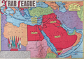 | Details | Sundberg, Edwin L. | 1946 |
| Colorful Scarce Coloroto Map Arab League Nations Middle East |
|
Sundberg, Edwin L. |
|
| 1946 |
| LOC:300 |
| $250.00 | Sundberg--Edwin-L- | Colorful-Scarce-Coloroto-Map-Arab-League-Nations-Middle-East | Colorful "Coloroto" rotogravure (1) map of the Middle East post WWII highlighting the Arab League member nations and prospective nations. Shows the seven nations that comprised the Arab League in July, 1946: Saudi Arabia, Egypt, Syria, Palestine, Iraq, Yemen, and Lebanon.
<br><br>
Formed March, 1945, the Arab League's purpose was "… draw closer the relations between member states and co-ordinate collaboration between them, to safeguard their independence and sovereignty, and to consider in a general way the affairs and interests of the Arab countries". (1)
<br><br>
(1) Coloroto is a trade name for a rotogravure used to print multiple colors. According to Google a rotogravure printing system uses a rotary press with <b>intaglio cylinders</b>, typically running at high speed and used for long print runs of magazines and stamps. (Google Oxford languages dictionary. Online).
<br>
<br>
(2) Pact of the League of Arab States, 22 March 1945. The Avalon Project. Yale Law School. 1998.
<br><br> |