| | Thumbnail | | Creator | Date | Title / Author / Date / Location | Price | | | Description |
| 6350 | 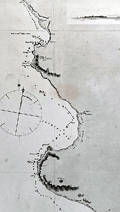 | Details | Fitz Roy, Robert | |
| Admiralty chart from 2nd Beagle Voyage along coastal Peru. |
|
Fitz Roy, Robert |
|
|
| LOC:67 |
| $365.00 | Fitz-Roy--Robert | Admiralty-chart-from-2nd-Beagle-Voyage-along-coastal-Peru- | Scarce original antique nautical chart of a portion of the coast of Peru between the Chicama River and Port Payta (Paita). A copper-plate engraving of a sea chart made under the auspices of Captain Robert Fitz Roy, R.N. (1805-1865) and the Officers of HMS Beagle.
<b>An important artifact from the hydrographic survey of the west coast of Peru made aboard the HMS Beagle on its second voyage, accompanied by Charles Darwin (1809 – 1882) as Naturalist. </b>
<br></br>
Traces of use at sea include manuscript track and bearing lines in pencil below Sechura Bay from the island of Lobos de Tierra to the island of Lobos de Afuera. Five finely engraved attractive inset elevation coastal views as seen from offshore.
<br></br>
Inset map of Point Eten based on an 1870 survey by a group including the H.M.S. Cameleon. A small warning that Eten Point is laid down on the map six miles east of its actual position.
<br></br>
Survey was conducted in 1836. First published by the British Admiralty on January 26, 1841 Last correction in December 1870. Engraved by J&C Walker. Sold by Potter. Chart # 1335. |
| 3672 | 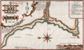 | Details | Frezier, Amedee | 1717 |
| Plan of the anchorage at Ilo, Peru |
|
Frezier, Amedee |
|
| 1717 |
| LOC:77 |
| $325.00 | Frezier--Amedee | Plan-of-the-anchorage-at-Ilo--Peru | Frezier's plan of the Peruvian port city of Ilo (Ylo), the capital of Ylo province. Frezier made a reconnaissance mission to the coast of South America from 1712-1714. Posing as a trader or merchant captain, Frezier sketched harbor defenses and gathered information on the military preparedness of each port visited.
<br></br>
Includes a coastal elevation view and several drawings of a mill probably for sugar cane. Key at top right relates to locations identified on the plan. North is oriented to the left.
<br></br>
Amédée Frézier (1682 – 1773) was an French explorer, military engineer, mathematician, and spy. This plan of Ylo, Peru is from Frezier's 1717 account of his travels published in French in 1717: "Relation du voyage de la mer du Sud, aux côtes du Chili, du Pérou et de Brésil, fait pendant les années 1712, 1713, et 1714". |
| 5151 | 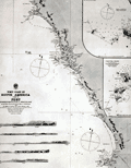 | Details | British Admiralty Hydrographical Office | 1882 |
| Chart of South America West Coast Callao Lima Pisco Bay |
|
British Admiralty Hydrographical Office |
|
| 1882 |
| LOC:0 |
| $350.00 | British-Admiralty-Hydrographical-Office | Chart-of-South-America-West-Coast-Callao-Lima-Pisco-Bay | Antique engraved sea chart of the west coast of Peru based on explorations by the ship Beagle. Coverage includes a wide stretch of coast that includes Callao (the port for Lima, Peru), and Pisco Bay with the Ballestas Islands (Ballista). Last corrections 1882. These charts are increasingly scarce.
<br></br>
This fine chart contains seven engraved inset coastal elevation views with features that include Huacho Head, Hormigas Rocks, Salinas Point, Calavera Head, and Mount Lechuza. Two inset harbors charts: Ancon Bay and Chincha Hills.
<br></br>
Published by the Admiralty September, 15th 1840. Sold by J. D. Potter. Engraved by J. & C. Walker. Chart number 1323.
<br></br>
Faint blue stamped sellers label for Phillip, Son & Nephew, Liverpool. |