| | Thumbnail | | Creator | Date | Title / Author / Date / Location | Price | | | Description |
| 4706 | 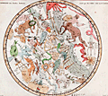 | Details | Fortin, J. | 1775 |
| Antique star chart of the Southern Hemisphere after Lacaille |
|
Fortin, J. |
|
| 1775 |
| LOC:13 |
| $280.00 | Fortin--J- | Antique-star-chart-of-the-Southern-Hemisphere-after-Lacaille | Fine decorative antique hand-colored engraved celestial star chart for the Southern Hemisphere from the Atlas Céleste de Flamstéed, updated and reduced by J. Fortin in 1776. This map of the Southern skies is based on Nicolas Louis de Lacaille’s star chart from 1754 in which Lacaille included 14 new constellations.
<br></br>
Lacaille sailed to South Africa in 1750 where he set up a small observatory at the Cape of Good Hope under the famous Table Mountain, which impressed him so much that he later named a constellation after it, Mensa. At the Cape in 1751 - 52 Lacaille observed the positions of nearly 10,000 stars. On his return to France in 1754, Lacaille presented a map of the southern skies to the French Royal Academy of Sciences which included 14 new constellations of his own invention. An engraved version of his celestial map was published in the Academy’s Mémoires in 1756 and Lacaille’s new constellations were rapidly accepted by other astronomers.
<br></br>
Flamsteed was born into a prosperous family & was largely self taught as he did not attend University due to poor health. He was appointed the first Astronomer Royal by King Charles II, with the Royal Observatory at Greenwich being built for him to continue his astronomical observations. Flamsteed's Celestial Atlas was first published ten years posthumously by his wife in 1729. It set the standard in professional astronomy for almost a century, with the positions of over 3,000 stars given more accurately than ever before.
<br></br>
French text for names of stars and constellations. Page 29. Lettered by Beauble' ; engraved by C.E. Voisard. |
| 1306 | 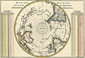 | Details | Bonne, Rigobert | 1787 |
| Antique Pre-Antarctica Southern Polar Projection |
|
Bonne, Rigobert |
|
| 1787 |
| LOC:9 |
| $325.00 | Bonne--Rigobert | Antique-Pre-Antarctica-Southern-Polar-Projection | Early antique South polar projection covering from the South Pole to the Equator. Produced by Bonne before the dimensions of continental Antarctica were known. This colorful antique map includes Australia (Nouvelle Hollande) and New Guinea.
<br></br>
Crisply and finely engraved to include mountain ranges and numerous place names with islands given extra coverage. Surrounded by two tables showing the distance corresponding to one degree at different latitudes. Published in Paris in 1787. Plate 23. |
| 1275 | 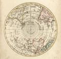 | Details | Walch, Johann | 1803 |
| Antique Southern Hemisphere polar view. |
|
Walch, Johann |
|
| 1803 |
| LOC:1 |
| $135.00 | Walch--Johann | Antique-Southern-Hemisphere-polar-view- | Attractive antique hand-colored <b>polar view</b> of the Southern Hemisphere. Perhaps most surprising about this copper-plate engraved polar map to modern eyes is the lack of an Antarctic Continent with its ice, which was not discovered by Europeans until much later. Published by Johann Walch, in his rare "Allgemeiner Atlas Nach den bewährsten Hülfsmitteln…", Augsburg, Germany, 1803.
<br></br>
Land details of this old map of the Southern Hemisphere include Van Dieman's Land (Tasmania), attached to Australia; Magellan's Land (Patagonia); Cook Strait in New Zealand; and Sandwich Land (not the Hawaiian Islands), discovered by Cook in 1775 and now the South Sandwich Islands. Notes the Amazon River, Congo, Madagascar, Paraguay, New Guinea, Java, and Borneo. |