| | Thumbnail | | Creator | Date | Title / Author / Date / Location | Price | | | Description |
| 7957 | 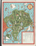 | Details | Page, Peter Hugh | 1941 |
| Rare third edition pictorial map of Stanley Park, Vancouver, British Columbia, Canada |
|
Page, Peter Hugh |
|
| 1941 |
| LOC:41 |
| $350.00 | Page--Peter-Hugh | Rare-third-edition-pictorial-map-of-Stanley-Park--Vancouver--British-Columbia--Canada | Beautiful lithographed pictorial map of Stanley Park, Vancouver, Canada by Peter Hugh Page, ca. 1941. Third Edition of three known editions by Peter Page. Shows Prospect Point, Brockton Point, Deadman's Island, Lost Lagoon, Second Beach, Beaver Lake and many other locations and attractions in Stanley Park.
<br><br>
<div align="center">
<a title="Stanley Park Cover"></a>
<img id="3" src="/ZoomifyImages/SC_6513/SC_6513_detail.jpg" alt="Cover from a brochure on Stanley Park, Vancouver, Canada by Peter Hugh Page in 1940." width="175"/> <br><small>Cover from Page's map of Stanley Park</small>
</div><br>
The third edition of Page's map of Stanley Park differs from the first and second editions in that it includes a label for Siwash Rock; the map shows, for the first time, the Illuminated Fountain built ca. 1936 in Lost Lagoon; and shows the Royal Vancouver Yacht Club site on Deadman's Island. Verso with text about Stanley Park. |
| 6834 | 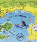 | Details | Melendez, Gilberto | 1955 |
| Fine mid-century pictorial map of Acapulco Mexico |
|
Melendez, Gilberto |
|
| 1955 |
| LOC:86 |
| $395.00 | Melendez--Gilberto | Fine-mid-century-pictorial-map-of-Acapulco-Mexico | Quite attractive touristic pictorial map of Acapulco Bay and surrounding areas. Inset map at top in a larger scale showing the road network between Acapulco and Mexico City. Additional inset map at right of Centro Downtown. Scarce.
<br><br>
Map contains an inset of the main advertiser, Hotel Caleta. Noted features include Isla la Roqueta, Puerto Marquez, el Patal Beach, Playa Suave, and many more. Inset tables identify local nightclubs and beaches. Produced by Gilberto Melendez. |
| 6616 | 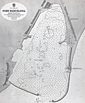 | Details | British Admiralty Hydrographical Office | |
| Original Admiralty harbor chart for Port Barcelona |
|
British Admiralty Hydrographical Office |
|
|
| LOC:57 |
| $900.00 | British-Admiralty-Hydrographical-Office | Original-Admiralty-harbor-chart-for-Port-Barcelona | Original 1873 British Admiralty harbor chart of the Port of Barcelona, Spain, issued as chart no. 1195. Published at the Admiralty in London under the superintendence of Rear Admiral G. H. Richards, Hydrographer, and based on Spanish surveys conducted in 1871. The chart was engraved by Edward Weller and drawn by H. Stafford. As with other Admiralty productions of the period, it reflects standardized hydrographic practices intended for practical navigation rather than decorative presentation.<br><br>
The chart details the harbor and immediate coastal approaches with extensive soundings, shoreline configuration, and port infrastructure as they existed in the early 1870s. Labeled features include Montjuich, the Arsenal, Punta de la Paz, Vista Alegro, Huertas de S. Beltran, and Barceloneta. Harbor works and alterations are shown, including the Old Mole light, noted as scheduled for demolition, documenting changes underway in the port’s configuration. The sheet captures Barcelona at a moment of transition, as the harbor was being adapted to accommodate increased commercial and industrial maritime traffic.<br><br>
British Admiralty charts were produced for active use by naval and commercial mariners and were regularly updated as surveys improved. As a result, early impressions such as this example are increasingly scarce in original form. This chart is of interest for its documentation of 19th century harbor engineering, Mediterranean navigation, and the development of Barcelona as a major port city, and it fits well within collections focused on nautical cartography, port plans, or European maritime history. |
| 6563 |  | Details | Deering, G.G. | 1919 |
| Painting on Gold Leaf Ship Marie Sophie of Falmouth |
|
Deering, G.G. |
|
| 1919 |
| LOC:0 |
| $975.00 | Deering--G-G- | Painting-on-Gold-Leaf-Ship-Marie-Sophie-of-Falmouth | Painting on Gold Leaf of the Schooner Ship Marie Sophie of Falmouth on Masonite and housed in an early frame (painted tan). Original brass hangers. Seller noted: "Unsigned but I believe this was done by Carroll A. Deering son of the owner of the G.G. Deering Shipyard at Bath, Maine (later Bath Iron Works)."
<br></br>
Purchased in 2013 with other Deering memorabilia from 1919.
<br><br>
According to an online article by the National Park Service about the ghost-ship Carroll A. Deering (l. 1919). <div class="indenttextblock"> On January 29, 1921, the ship was making a return trip to Hampton Roads, Virginia from Barbados when she passed the Cape Lookout Lightship. According to the lightship a crewman, who did not look or act like an officer, reported that the ship had lost its anchors.
<br><br>
This was the last report of the ill-fated Deering before she was found run aground and abandoned. At 6:30 am on January 31st, C.P. Brady of the Cape Hatteras Coast Guard Station spotted a five-masted schooner in the morning light, aground and helpless on the shoals…. Upon investigating the ship, it was discovered that all personal belongings, key navigational equipment, certain papers, and the ship’s anchors were missing. Food was laid out as if in preparation for a meal. But there was no sign of the crew.
Source: http://www.nps.gov/caha/historyculture/theghostship.htm</div> |
| 6553 |  | Details | U.S. Coast and Geodetic Survey | 1916 |
| 8 Charts Inside Route New York to Key West or ICWW 1916 |
|
U.S. Coast and Geodetic Survey |
|
| 1916 |
| LOC:300 |
| $585.00 | U-S--Coast-and-Geodetic-Survey | 8-Charts-Inside-Route-New-York-to-Key-West-or-ICWW-1916 | Very scarce and complete set of eight U.S. Coast and Geodetic Survey folding navigational charts for the inside route for maritime traffic on the eastern coast of the United States from New York South. Third edition. These historical charts from 1916 predate the U.S. Government's ownership of the route which later became part of the Intracoastal Waterway (ICWW) . Placed end to end, the charts would extend over 18 feet long.
<br><br>
Includes the 94 page Coast Survey Sailing Directions that once housed the 8 charts in an attached interior envelope. Card cover. Binding intact. Price when issued was 20 cents.
<BR> </BR>
A bit of research shows that in its early history some portions of the inside route were owned and dredged by private entities who charged a toll to vessels for passage, sometimes by stringing a chain across narrow passages to restrict traffic flow. In fact, chart 7 contains manuscript pencil annotations, obviously made during a voyage, of "Toll" and "Toll chain" that reflects that little-known fact. Interestingly, the toll chains are not noted as part of the official chart. After 1919 Congress mandated that the entire passage should be turned over to the Federal government and the tolls were eliminated.<BR> </BR>
Size of each chart when folded is approximately 8" x 5". These 8 lithographed working navigational charts capture the full extent of the eastern U.S. inside route in detail with some manuscript pencil annotations, especially in Florida. Chart sections include roughly these areas and chart sizes: (one dimension is typically 10" and the other dimension is below). <BR>
1. Jersey City to Philadelphia - 10" <BR>
2. Philadelphia to Norfolk - 33" <BR>
3. Norfolk to Cape Lookout - 28" <BR>
4. Cape Lookout to Murphy Island - 31" <BR>
5. Murphy Island to Fernandina - 35" <BR>
6. Fernandina to Cape Canaveral -28" <BR>
7. Cape Canaveral to Miami -32" <BR>
8. Miami to Key West - 24" <BR> |
| 6486 | 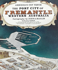 | Details | Maslin, John A. | 1985 |
| America's Cup pictorial bird-eye view of Freemantle, Western Australia |
|
Maslin, John A. |
|
| 1985 |
| LOC:1404 |
| $350.00 | Maslin--John-A- | America-s-Cup-pictorial-bird-eye-view-of-Freemantle--Western-Australia | Attractive oblique pictorial birds-eye view map of the town and harbor of Freemantle, Western Australia. July 1985 edition. Copyrighted and produced by Ausimap, Perth. Cartography by John A. Maslin.
<br><br>
In addition to Cockburn Sound and Freemantle Harbor the expansive birds-eye view shows Success Harbor, the fishing boat harbor, and the America's Cup harbour at Freemantle.
<br><br>
Two years before this map was published, and for the first time in 132 years, the America’s Cup was won by a team from other than the USA. That year, in Rhode Island, Australia II, skippered by John Bertrand defeated Dennis O'Conner on the Liberty. In 1987 the America's Cup race was held in Freemantle, Australia where the Stars & Stripes 87 won the series in a four-race sweep. |
| 775 |  | Details | Hunt and Company | 1886 |
| Hunts Universal Yacht List 1886 |
|
Hunt and Company |
|
| 1886 |
| LOC:0 |
| $425.00 | Hunt-and-Company | Hunts-Universal-Yacht-List-1886 | A great gift for a sailing or yachting enthusiast. Hunts Universal Yacht List for 1886 contains 29 pages of colour printed yacht club flags and colored flags for individual yawls, schooners and cutters, with over 60 pages of interesting trade advertisements (many illustrated). This scarce, compact, antique volume is the 1886 edition in a series that were published annually between 1848 and 1914. Contains a long alphabetical list of specifications for 4800 largely British yachts including the following fields: name of yacht; rig; length; beam; tonnage; depth; owners; a key to the name of one the 61 participating yacht clubs; signal letters; year built; year altered; builder; sailmaker; and distinguishing flag.
<br></br>
Includes signal flags in color along with regatta dates, a list of owners, list of agents, staff and yachts of all the principal yacht clubs of the World, tide tables, prize winners, etc.
<br></br>
Bound in the original blue cloth boards, with gilt lettering and a royal crest to the upper cover. Professionally re-backed in gilt-decorated navy-blue morocco. Publisher: London: Hunt & Co., 119 Church Street, London. 422 pages. |
| 488 |  | Details | Haffenreffer, R.F. | 1940 |
| Yachts by Herreshoff |
|
Haffenreffer, R.F. |
|
| 1940 |
| LOC:0 |
| $150.00 | Haffenreffer--R-F- | Yachts-by-Herreshoff | Promotional book by the Herreshoff Manufacturing Company, Bristol, Rhode Island ca. 1940. Contains eight color reproductions of America's Cup race winners built by Herreshoff, after drawings by R.F. Paterson. These classic vessels designed by Nathanael G. Herreshoff or W. Starling Burgess include the Vigilant, Defender, Columbia (2), Reliance, Resolute, Enterprise and Rainbow. A "Roll of Honor" for these successful America's Cup defenders on page 47 shows that the boats were owned by many of the business leaders of the early 20th century including Cornelius Vanderbilt, Vincent Astor, Alfred Sloan, J.P. Morgan, and Walter Chrysler, among others.
<BR> </BR>
With numerous other black and white photographs of Herreshoff-built boats and manufacturing processes. Contains plans and specifications on glassine paper for eight smaller Herreshoff one-design class offerings from 11 to 31 feet. Table of Contents and Registry of Owners.
<BR> </BR>
Number 8741 presented to J.G. Sheldon. 53 pages as issued. |