| | Thumbnail | | Creator | Date | Title / Author / Date / Location | Price | | | Description |
| 1293 | 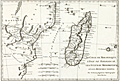 | Details | Bonne, Rigobert | 1774 |
| Antique map of East Africa and Madagascar |
|
Bonne, Rigobert |
|
| 1774 |
| LOC:0 |
| $0.00 | Bonne--Rigobert | Antique-map-of-East-Africa-and-Madagascar | SOLD<br></br>
Antique copper-plate engraved map of East Africa, Madagascar, and the Comoros Islands engraved by Andre' and issued by Rigobert Bonne in 1774. Number 96.
<br></br>
Rigobert Bonne was the successor to Jacques Nicolas Bellin as Royal Cartographer to France in the office of the Hydrographer at the Depôt de la Marine. |
| 6704 | 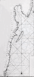 | Details | Mannevillette, d'Apres | 1775 |
| Chart of the east coast of Madagascar |
|
Mannevillette, d'Apres |
|
| 1775 |
| LOC:68 |
| $475.00 | Mannevillette--d-Apres | Chart-of-the-east-coast-of-Madagascar | Original French nautical chart of a portion of the east coast of the island of Madagascar, off the east coast of Africa. From the second edition of Le Neptune Oriental published 1775 in Paris.
<br><br>
The most prominent feature of the chart is Antongil Bay, a large bay located on the northeast coast of Madagascar. The bay is known for its beautiful beaches, rich biodiversity, and important fishing industry. The surrounding area is also home to several protected areas, including the Masoala National Park and the Nosy Mangabe Special Reserve.
<br><br>
Antongil Bay has a rich history dating back to the early days of Madagascar's settlement by humans. The bay was a major center of trade and commerce for the island's indigenous populations, who used it to transport goods and communicate with other communities along the coast.
<br><br>
During the colonial period, Antongil Bay became an important center of trade for the French, who established several ports along its shores. The bay was used to transport goods such as vanilla, cloves, and other spices, which were grown on plantations throughout the region
<br><br>
The chart includes large-scale inset plans for the following bays and anchorages:
<div class="indenttextblocksingle">
<ul style="list-style-type: circle;"></li>
<li>Plan de l'Ance de Tamatave</li>
<li>Plan de l'Anse de Veninguebe</li>
<li>Plan du Port de Teintingue</li>
<li>Plan de la Rade de Fullpointe</li>
</ul>
</div> |