| | Thumbnail | | Creator | Date | Title / Author / Date / Location | Price | | | Description |
| 881 | 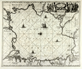 | Details | Dapper, Olfert (Olivier) | 1672 |
| Antique engraved chart or map of the Caspian Sea |
|
Dapper, Olfert (Olivier) |
|
| 1672 |
| LOC:8 |
| $250.00 | Dapper--Olfert-(Olivier) | Antique-engraved-chart-or-map-of-the-Caspian-Sea | Interesting antique chart of the <b>Caspian Sea</b>, considered by many to be the world's largest lake, located between Europe and Asia. This 340 year old copper-plate engraving by Olivier Dapper (d. 1690) is presented in the <b>style of a nautical chart </b>with numerous rhumb lines and a central compass rose at center. No soundings, aids-to-navigation or danger areas are identified, which is consistent with the intended use of the work to inform the general reader, and definitely not intended for navigation of the Caspian Sea.
<br></br>
This old map is filled with images of sailing ships and shows limited detail of the interior areas of the countries along the Caspian coast: Russia, Kazakhstan, Turkmenistan, Iran, and Azerbaijan. Text is in both Cyrillic and Dutch. |
| 1055 | 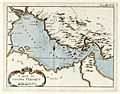 | Details | Bellin, Jacques Nicolas | 1764 |
| Antique French Chart of the Persian Gulf Region |
|
Bellin, Jacques Nicolas |
|
| 1764 |
| LOC:9 |
| $350.00 | Bellin--Jacques-Nicolas | Antique-French-Chart-of-the-Persian-Gulf-Region | Antique French maritime map of the <b>Persian Gulf</b> by the French cartographer Jacques-Nicolas Bellin (1703−72). <b>Qatar</b> is shown as Catura. Cities on both the Arabian and Persian sides of the gulf are indicated, and the map shows a river emptying into the gulf at the port of Julfar (present-day Ra's al-Khaymah, United Arab Emirates). Key features include the islands of "Baharem" (Bahrain), "Ormus" (Hormuz), and "Kimishe" (Qeshm); and the city of Banderabashi (Bandar Abbas, Iran),
<br></br>
From Bellin's "Le Petit Atlas Maritime: Recueil de Cartes et de Plans des Quatre Parties du Monde" (Small maritime atlas: collection of maps and charts of the four parts of the world), in five volumes containing 581 maps in total.
<br></br>
Plate 8, Tome 3. |
| 666 | 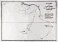 | Details | Dalrymple, Alexander | 1890 |
| Track of the ship Pearl in Persian Gulf 1797 |
|
Dalrymple, Alexander |
|
| 1890 |
| LOC:0 |
| $0.00 | Dalrymple--Alexander | Track-of-the-ship-Pearl-in-Persian-Gulf-1797 | SOLD <br></br>
Scarce copper plate engraved chart from 1797 of a portion of the coast in Hormozgan Province, Iran. Shows the Iranian coast near the island of Jezīrat Sheikh-Shuaib or Lavan Island ( Busheab Island ) and the present-day Nayband Marine-Coastal National Park. Other named features include Shitwa Island, Cape Nabon, Barn Hill, Cape Verdistan, Mongella Island, and Kenn Island. The chart contains soundings recorded by the Pearl during its exploration of the region during May 25 - 27, 1796.
<br></br>
Published by Alexander Dalrymple on May 7, 1797. This plate is a re-issue from the original copper plate bearing the stamp of the British Hydrographic Office; late 19th century or early 20th century.
<br></br>
In his doctoral thesis Cook wrote of Dalrymple that he was: <div class="indenttextblock"> "now generally regarded as the originator of official British hydrography… was cumulatively a private publisher of nautical charts and plans (from 1767), the 'examiner of ships' journals' and chart publisher for the East India Company (from 1779), and Hydrographer to the Admiralty (from 1795)". </div>
<br>
<div class="indenttextblock">Reference: Cook, Andrew S., <b>Alexander Dalrymple (1737 - 1808) Hydrographer to the East India Company and to the Admiralty; as publisher: A Catalogue of Books and Charts. </b> Vol. 3 .Doctoral Thesis, University of St. Andrews. 1992.</div> |