| | Thumbnail | | Creator | Date | Title / Author / Date / Location | Price | | | Description |
| 3577 | 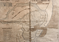 | Details | Anonymous | 1750 |
| MS 18th century hydrographic map of the Fayoum Region - Egypt - Arsinoe - Lake Moeris |
|
Anonymous |
|
| 1750 |
| LOC:0 |
| $17,000.00 | Anonymous | MS-18th-century-hydrographic-map-of-the-Fayoum-Region---Egypt---Arsinoe---Lake-Moeris | Rare detailed, unsigned French manuscript hydrographic map of the Fayoum region of Egypt “the Land of the Lake” with Lake Moeris (Qarun). With an elevation view and floor plan of a building considered to be the "Labyrinthe" mentioned by Herodotus. Ca. 1720 - 1750. Possibly the earliest map to focus on the Fayoum region.
<br></br>
This 18th century MS map locates archaeological sites and features the extensive network of rivers, streams, and canals that emptied into Lake Moeris from the Nile River via the Bahr Yusuf canal. Shows seven smaller canals from the Bahr Yusuf emptying into "Lake Moeris ou de Caron Nomne a presant Lac de la Corne". The hydrography and naming (ex. "Lac de la Corne", "Chateau de Caron") are similar to <a href="https://gallica.bnf.fr/ark:/12148/btv1b531002007/f1.item.zoom" target="_blank">Claude Sicard's map of Egypt</a> copied in MS by Guillaume Delisle in 1726.
<br></br>
The Fayoum (also Fayum, Faioum) region was once the center of the cult of Sobek, an Egyptian deity associated with the crocodile. Medinet el-Faiyum or Shedet was the ancient regional capital. The town was called "Crocodilopolis" by the Greeks (renamed Arsinoë by the Romans). Camels and crocodile are shown near the southwest shore of the lake with several pyramids, grottos, ruins, and Coptic Christian sites.
<br></br>
The map wrongly identifies the Ptolemaic temple at Qasr Qaroun as the Labyrinth described by Herodotus.
<br></br>
French explorers who first vested the Fayoum region include Paul Lucas (1714-17), Jomard (1800), P.D. Martin (1801), and Linant de Bellefonds (1821). By 1800 Edme-Francois Jomard in "Emplacement de l'ancien lac Moaris et du Labyrinthe dans le Fayoum d'après tous les Auteurs" had correctly determined that the site of the Labyrinth lay not at Qasr Qaroun, but rather at a mud-brick temple near Hawara. Our estimated date of this map to the 18th century rests on this timeline and on dates of other maps from the same purchase. |
| 1152 | 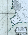 | Details | Bellin, Jacques Nicolas | 1764 |
| Plan du Fort et du Village du Bequier |
|
Bellin, Jacques Nicolas |
|
| 1764 |
| LOC:6 |
| $180.00 | Bellin--Jacques-Nicolas | Plan-du-Fort-et-du-Village-du-Bequier | Shows the village and fort at Aboukir ("Bequier"), Egypt north of Alexandria on the North African coast of the Mediterranean Sea. Aboukir Bay was the site where British Admiral Horatio Nelson fought the naval <b>Battle of the Nile</b> on August 1, 1798 also referred to as the "Battle of Aboukir Bay". From Bellin's <b>Le Petit Atlas Maritime</b> . |
| 1153 | 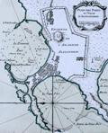 | Details | Bellin, Jacques Nicolas | 1764 |
| Plan des Ports et Ville d'Alexandrie |
|
Bellin, Jacques Nicolas |
|
| 1764 |
| LOC:6 |
| $250.00 | Bellin--Jacques-Nicolas | Plan-des-Ports-et-Ville-d-Alexandrie | This fine maritime chart / plan shows the ancient walled town of <b>Alexandria, Egypt</b> on the North African coast of the Mediterranean Sea. The plan includes both the old port and to the east, the new port.
<br></br>
Includes a representation of <b>Pompey's Pillar</b>. The "Colonne de Pompee" is a 30-meter tall monolithic Roman triumphal column in Alexandria, Egypt, and the largest of its type constructed outside the imperial capitals of Rome and Constantinople. Numerous soundings, hazards, and anchorages attest to the nautical nature of this plan. From Bellin's <b>Le Petit Atlas Maritime</b> .
<br></br>
Tome III No. 86. |
| 1154 | 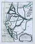 | Details | Bellin, Jacques Nicolas | 1764 |
| Antique chart of the Nile Delta north of Alexandria, Egypt |
|
Bellin, Jacques Nicolas |
|
| 1764 |
| LOC:6 |
| $250.00 | Bellin--Jacques-Nicolas | Antique-chart-of-the-Nile-Delta-north-of-Alexandria--Egypt | Fine antique map of the waterways crisscrossing the Nile delta from Suez west past Alexandria, Egypt. Noted features include: "Lac Mareotis" (Lake Mariout or Maryut); the Isthmus of Suez and upper tip of the Gulf of Suez; "Rosette" (Rosetta, the location of the discovery of the archaeologically important rock stele known as the Rosetta Stone.)
<br></br>
From Bellin's <b>Le Petit Atlas Maritime</b> .Tome III, No. 89. |
| 1158 | 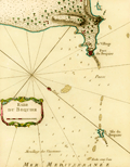 | Details | Bellin, Jacques Nicolas | 1764 |
| Antique engraved chart of the anchorage at Aboukir Bay |
|
Bellin, Jacques Nicolas |
|
| 1764 |
| LOC:6 |
| $265.00 | Bellin--Jacques-Nicolas | Antique-engraved-chart-of-the-anchorage-at-Aboukir-Bay | This colorful antique French chart shows the anchorage ("Mouillage des Vaisseaux") and waters near the "Fort du Bequier" and "Isle du Bequier" at Aboukir ("Bequier"), Egypt. Aboukir lies north of Alexandria on the Mediterranean Sea coast of North Africa.
<br></br>
Aboukir Bay was the site where British Admiral Horatio Nelson fought the naval <b>Battle of the Nile</b> on August 1, 1798 also referred to as the "Battle of Aboukir Bay". Ironically, the French were badly defeated by the British at the battle in part because the British had better information about water depth in the area.
<br></br>
From Bellin's <b>Le Petit Atlas Maritime</b> .
<br></br>Tome III, No 88. |
| 3649 |  | Details | Probst, Georg Balthasar | 1780 |
| Unusual vue d'optique of the Egyptian Pyramids |
|
Probst, Georg Balthasar |
|
| 1780 |
| LOC:88 |
| $400.00 | Probst--Georg-Balthasar | Unusual-vue-d-optique-of-the-Egyptian-Pyramids | The "third wonder of the world". That’s how Probst describes the Egyptian Pyramids in this vue d'optique, made about 1780. This colorful antique view reflects the limited knowledge of a late 18th century European and errs most egregiously in the height to width ratio of the pyramids, of which Probst obviously had no first hand experience. Really quite a theatrical setting. By Georg B. Probst. Folio no. 43.
<br></br>
A vue d'optique is a print was designed to be looked at through a zograscope, a device designed to give an illusion of depth using mirrors and lenses. The image and title at the top of the vue have been transposed left to right. The prints were placed into a view box and for a small price viewers could look through a lens to see the print. Zograscopes were used as entertainment in Georgian times and collections of these prints could be hired for the evening from print sellers.
<br></br>
Georg Balthasar Probst was the most important member of an Augsburg family of artists and publishers. Probst produced about 400 vue's d'optique on varied subject matter. |
| 1034 | 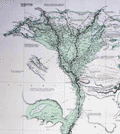 | Details | Leake, William Martin | 1818 |
| Map of Egypt, Nile River |
|
Leake, William Martin |
|
| 1818 |
| LOC:1403 |
| $1,295.00 | Leake--William-Martin | Map-of-Egypt--Nile-River | Very large and impressive <b>full-width example</b> of Leake's map of the Nile river from 1818 (29" x 50" at neatline). Rolled, and <b>NOT dissected.</b> Clean, bright, and strong. Scarce, as the map is not dissected and is in fine condition. Guaranteed original copper-plate engraved map by Sidney Hall for Aaron Arrowsmith. Dated at bottom to 1818. Two sheets well joined.
<br></br>
Published by Aaron Arrowsmith who in his early twenties worked for John Cary, the engraver and William Faden. Aaron Arrowsmith (1750-1823) founded a cartographic dynasty and was a close contemporary of Alexander Dalrymple (Hydrographic Office), Joseph Banks (Naturalist), Flinders and others of the period. Arrowsmith became Geographer to the Prince of Wales in 1810 and ultimately <b>Hydrographer to the King</b> in 1820.
<br></br>
This hand-colored, original map "Course of the Nile" was produced by Lieutenant Colonel W.M. Leake. William Martin Leake, a leading British authority on the region. In 1802, Leake and others were employed to make a general survey of Egypt. Leake's chart was published in 1818 after his retirement, incorporating additional material from Bryce and others. The map provides extensive information on the Nile, archaeological sites, the Sea of Suez, roads and railways. Numerous annotations are included about the areas extensive history and its inhabitants. Note: The Suez Canal is not included in this chart because that waterway was not completed until 1869, more than 50 years after this map was published. |
| 5465 | 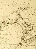 | Details | Smyth, William Henry | 1830 |
| Rare unrecorded chart of Alexandria Egypt after Smyth |
|
Smyth, William Henry |
|
| 1830 |
| LOC: |
| $250.00 | Smyth--William-Henry | Rare-unrecorded-chart-of-Alexandria-Egypt-after-Smyth | Unrecorded French nautical chart of the town, anchorages and environs around Alexandria, Egypt after a chart by Captain William Henry Smyth. Published by Bellue Libraire, Toulon, France in 1830. Lithographed by Moquin & Co., Montpellier.
<br></br>
Based on the survey of William Henry Smith R.N. (1788 - 1865) in 1822 aboard the surveying sloop Adventure, 6 guns.
<br></br>
Manuscript pencil notation and course tracks.
<br></br>
Mid-20th century conservation effort with the chart laid to linen and protected via thin-film lamination process to both recto and verso. |
| 784 | 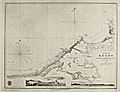 | Details | Smyth, William Henry | 1857 |
| The Coast of Egypt from Alamaid to the Rosetta Branch of the Nile |
|
Smyth, William Henry |
|
| 1857 |
| LOC:0 |
| $550.00 | Smyth--William-Henry | The-Coast-of-Egypt-from-Alamaid-to-the-Rosetta-Branch-of-the-Nile | Fascinating antique nautical chart of the Egyptian coast including Alexandria (Iskanderiah), Egypt, with its old port, and Aboukir Bay, the site of Admiral Horatio Nelson's decisive victory over the French fleet of Napoleon Bonaparte at the Battle of the Nile (Fr. Bataille d'Aboukir). At extreme right of the chart is one of the tributaries of the Nile River with the town of Rosetta ( Raschid ) and to the Northeast Fort Raschid now renamed Fort Julien. Fort Raschid is perhaps best known as the location where the stele known as the "Rosetta Stone" was discovered during a reconstruction in 1799.
<br></br>
This chart is a 1857 copperplate engraved edition of a nautical chart originally published in 1822 by W.H. Smyth of the British Royal Navy. This fine chart was made based on work conducted aboard the ship Adventure in 1821 as part of Smyth's survey of the North coast of Africa from the Strait of Gibraltar to the mouth of the Nile River.
<br></br>
With two inset coastal profiles: "Abukeer Castle from the Eastward", a pretty view of a felucca under full sail passing offshore Aboukir Castle (Taposiris Parva) and "Arab's Tower S.E. 10 miles".
<br></br>
With the oval logo of the British Hydrographical Office. Price when issued was 2 shillings. Number 242.
<br></br> |