| | Thumbnail | | Creator | Date | Title / Author / Date / Location | Price | | | Description |
| 1092 | 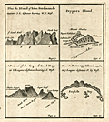 | Details | Moll, Herman | 1699 |
| First printed map of Peypses or Pepys Island. |
|
Moll, Herman |
|
| 1699 |
| LOC:5 |
| $0.00 | Moll--Herman | First-printed-map-of-Peypses-or-Pepys-Island- | SOLD <br></br>Four scarce views on one sheet based on a manuscript maps drawn by <b>William Ambrosia Cowley</b>. The views are of: the Island Of John Ferdinando; the perhaps fictitious Peypses Island; Nutmeg Island; and the Cape of Good Hope, at the southern tip of the African continent.
<br></br>
Cowley was sailing master of a pirate ship captained by John Eaton in 1684 when they made landfall at the Galapagos Islands in the Pacific Ocean. Cowley's narrative of the voyage entitled 'Cowley's Voyage Around the Globe' was published in the 'COLLECTION OF ORIGINAL VOYAGES' by William Hacke from London in 1699.
<br></br>
In Cowley's manuscript journal he recorded his landing at an island he called <b>Pepyes Island</b>:
<div class="indenttextblock">
"We held our Course S. W. till we came into the lat. of 47 deg. where we saw Land; the same being an Island not before known, lying to the Westward of us. It was not inhabited, and I gave it the Name of Pepys Island. We found it a very commodious place for Ships to water at and take in Wood, and it has a very good Harbour, where a thousand sail of Ships may safely ride: Here is great plenty of Fowls, and we judge, abundance of Fish, by reason of the Grounds being nothing but Rocks and Sands. "
</div>
Of John Ferdinando (Isla Juan Fernandez or Más a Tierra) Cowley wrote:
<div class="indenttextblock">
"Capt. Bartholomew Sharpe was here in the Year 1680, and finding no People on it, he called it Queen Catherines Island; and when he sailed away did leave one Man on shoar, which was a Mosquito Indian, who lived here alone near 4 Years. … there being several of our Ships Company who were at the leaving of this Indian there by Capt. Sharpe, and among others Capt. Edmond Cook and Mr. William Dampier". (Cowley, W.A., "Cowley's Voyage Around the Globe" <a href="http://www.galapagos.to/TEXTS/COWLEY.HTM#GalapagosSection" target="_blank">Internet</a>)
</div> |
| 81 |  | Details | Bellin, Jacques Nicolas | 1757 |
| Isles Britanniques, Troisieme Feuille |
|
Bellin, Jacques Nicolas |
|
| 1757 |
| LOC:0 |
| $500.00 | Bellin--Jacques-Nicolas | Isles-Britanniques--Troisieme-Feuille | Impressive antique copperplate nautical chart of Scotland (Edinburgh), Firth of Forth, Aberdeen, Dundee, Glasgow, Firth of Clyde, the Irish Sea and Northern Ireland (Londonderry) on very thick wove paper. Published by J.N. Bellin of the Depot de la Marine in 1757. The antique chart contains a large, decorative, dated title cartouche in upper right. Single vertical fold as issued. |
| 83 |  | Details | Bellin, Jacques Nicolas | 1757 |
| Isles Britanniques, Second Feuille |
|
Bellin, Jacques Nicolas |
|
| 1757 |
| LOC:0 |
| $510.00 | Bellin--Jacques-Nicolas | Isles-Britanniques--Second-Feuille | Impressive, large antique copperplate-engraved nautical chart of Wales (Isle of Anglesey), Northern Britain (Isle of Man, Yarmouth) , Scotland, and Eastern Ireland (Belfast, Dublin) on very thick wove paper. Published by J.N. Bellin of the Depot de la Marine in 1757. Single vertical fold as issued. Heavy impression. (Second sheet also available). |
| 615 |  | Details | Klint, Gustaf | 1803 |
| Scarce Swedish chart of the British Isles by Admiral Gustaf Klint |
|
Klint, Gustaf |
|
| 1803 |
| LOC:0 |
| $1,500.00 | Klint--Gustaf | Scarce-Swedish-chart-of-the-British-Isles-by-Admiral-Gustaf-Klint | Original antique nautical chart of the British Isles from 1803 by Admiral Gustaf Klint (1771 - 1840) of the Swedish Royal Navy. This scarce antique "Karta ofver Brittiske Öarne" covers the Shetland, Faroe, and Orkney Islands, England, Scotland, Wales, and Ireland to Cornwall and the western coast of France below Calais. The engraving on this chart is quite exceptional and with added color could be a startling conversation piece. <br></br>
Charts of the British Isles by Admiral Klint are scarce as most of his hydrographic efforts were spent on his native land, Sweden- principally the Gulf of Bothnia. Klint is also known for his sailing directions of the Baltic Sea, Gulf of Finland, and Gulf of Bothnia, published posthumously. Number 19. <sup>1</sup>
Swedish text.<br></br>
<sup>1</sup> Dawson, L.S. ( Commander ). "Memoirs of Hydrography including brief biographies of the Principal Officers who have served in H.M. Naval Surveying Services between the years 1750 and 1885". Part II. 1885. [ http://books.google.com/books?id=3SwBAAAAQAAJ&dq=gustaf+klint+admiral&source=gbs_navlinks_s ] |
| 5362 | 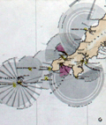 | Details | Corporation of Trinity House | 1863 |
| Rare Chart Lighthouses of Great Britain and Ireland |
|
Corporation of Trinity House |
|
| 1863 |
| LOC: |
| $0.00 | Corporation-of-Trinity-House | Rare-Chart-Lighthouses-of-Great-Britain-and-Ireland | SOLD
<br></br>
A fine, very large chart of Great Britain, Ireland, and the west coast of Europe showing lighthouses and lightships active in 1863. Inset charts. Constructed by Alexander G. Findlay. Published Jan 1, 1863 by R.H. Laurie, no. 53 Fleet Street, London. Other editions of this work were published from 1833 to 1888.
<br></br>
No sales of any edition of this work recorded in AMPR. No copies are found for sale online as of October, 2020. About six institutional copies of the 1863 edition are recorded in WorldCat.
<br></br>
Dissected and mounted on linen. Folded into covers with brass decorative gothic clasps. Boards are covered in cloth with a blind stamped decoration and the title, motto "Trinitas in Unitate", and the coat of arms of Trinity House in gilt.
<br></br>
The Trinity House was originally a guild of shipmen and mariners established by Henry VIII in 1517 to support and expand shipping in England. Later the Trinity House was tasked with maintaining buoys, lighthouses, and aids to navigation on the English coast as well as licensing ship's pilots. (Oxford Companion to Ships and The Sea, Peter Kemp, ed. Oxford University Press. London, 1976, p. 889.)
<br></br>
Note: Due to the large size of the chart, the image is a composite of two photographs and may display some small artifacts of the join at left. |
| 1262 |  | Details | Depot de la Marine | 1868 |
| Antique sea chart of the Falkland Islands or Islas Malvinas |
|
Depot de la Marine |
|
| 1868 |
| LOC:0 |
| $0.00 | Depot-de-la-Marine | Antique-sea-chart-of-the-Falkland-Islands-or-Islas-Malvinas | SOLD<br></br>
Fine and scarce antique French nautical chart of the <b>Falkland Islands</b> after earlier surveys by Fitz-Roy, Robinson, and Sullivan of the British Admiralty. This large mid nineteenth-century navigation chart makes a very attractive presentation with its clean and bright appearance.
<br></br>
Originally published in 1850, this edition contains corrections to 1868. Contains inset elevation views of the Falklands coast. |
| 764 |  | Details | Depot de la Marine | 1878 |
| Antique Nautical Chart of the North Sea and British Isles |
|
Depot de la Marine |
|
| 1878 |
| LOC:0 |
| $250.00 | Depot-de-la-Marine | Antique-Nautical-Chart-of-the-North-Sea-and-British-Isles | Large French antique nautical chart of the North Sea and the British Isles published in 1867 and updated with corrections to 1878. Detailed coverage includes the coasts of France, Belgium, Holland, Denmark, and Norway from Bordeaux, France at the south all the way to Averoy, Norway at the north. Includes the Faroe, Orkney, and Shetland islands, the Skaggerak, English Channel ( la Manche ) , Irish Sea, and North Sea.
<br></br>
Several hundred coastal lighthouses and lighted navigational aids are highlighted with a red dot and a yellow highlight. Three pasted on paper corrections at bottom when issued by the Depot de la Marine. Number 2367. |
| 775 |  | Details | Hunt and Company | 1886 |
| Hunts Universal Yacht List 1886 |
|
Hunt and Company |
|
| 1886 |
| LOC:0 |
| $425.00 | Hunt-and-Company | Hunts-Universal-Yacht-List-1886 | A great gift for a sailing or yachting enthusiast. Hunts Universal Yacht List for 1886 contains 29 pages of colour printed yacht club flags and colored flags for individual yawls, schooners and cutters, with over 60 pages of interesting trade advertisements (many illustrated). This scarce, compact, antique volume is the 1886 edition in a series that were published annually between 1848 and 1914. Contains a long alphabetical list of specifications for 4800 largely British yachts including the following fields: name of yacht; rig; length; beam; tonnage; depth; owners; a key to the name of one the 61 participating yacht clubs; signal letters; year built; year altered; builder; sailmaker; and distinguishing flag.
<br></br>
Includes signal flags in color along with regatta dates, a list of owners, list of agents, staff and yachts of all the principal yacht clubs of the World, tide tables, prize winners, etc.
<br></br>
Bound in the original blue cloth boards, with gilt lettering and a royal crest to the upper cover. Professionally re-backed in gilt-decorated navy-blue morocco. Publisher: London: Hunt & Co., 119 Church Street, London. 422 pages. |
| 6375 |  | Details | Owen, G. Frederick | 1942 |
| Foundational topographic birds eye view of Palestine |
|
Owen, G. Frederick |
|
| 1942 |
| LOC: |
| $1,200.00 | Owen--G--Frederick | Foundational-topographic-birds-eye-view-of-Palestine | Original, scarce <b>first-edition</b> foundational birds-eye view of Palestine from 1942 by author and Middle-East expert G. Frederick Owen (1897-1987). In 1942 a group of Zionists in the United States adopted a set of resolutions titled the <b>Biltmore Program</b>, calling for <b>open immigration to Palestine</b> and the establishment of <b>Palestine as a Jewish Commonwealth</b>. Owen's 1942 small-scale view of Palestine pre-dates by six years the independence of the Jewish state of Israel in 1948.
<br></br>
Owen's 1942 lithographed map of Palestine in Third Dimension was cited by UCLA's Gerry Hale as among 18 of the best Middle-East reference and wall maps available in the West (1972), and was the only map to focus on Palestine in Hale's list [1]. Owen's map was published in six editions (1942, 1942*, 1955, 1955, 1967 and 1981). In 1947 Owen designed and edited a similar but larger-scale bird-eye view "Jerusalem in Third Dimension." Relief is shown pictorially and by shading.
<br></br>
A deep dive into WorldCat confirms only <b>four institutional holdings</b> of the 1942 first edition: LOC, BYU, Amherst, Harvard.
<br></br>
Copyright 1942 by G. Frederic Owen. Published by Beacon Hill Press, Kansas City, Missouri.
<br></br>
Palestine in Third Dimension Designed and Edited by G. Frederick Owen Member of the Palestine Oriental Society and the American School of Oriental Research
<br></br>
Sources:
<br></br>
[1] Hale, Gerry A. International Journal of Middle East Studies, vol. 3, no. 4, Cambridge University Press, 1972, pp. 505–08, http://www.jstor.org/stable/162501. |