| | Thumbnail | | Creator | Date | Title / Author / Date / Location | Price | | | Description |
| 114 |  | Details | Ogilby, John | 1671 |
| Brasilia |
|
Ogilby, John |
|
| 1671 |
| LOC:0 |
| $0.00 | Ogilby--John | Brasilia | SOLD. .<BR> </BR>
Map of Eastern Brazil published after a work by Arnoldus Montanus. West is shown at top of map. |
| 4823 | 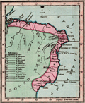 | Details | Luffman, John | 1801 |
| Antique map of Brazil engraved for Luffman's Select Plans |
|
Luffman, John |
|
| 1801 |
| LOC:77 |
| $230.00 | Luffman--John | Antique-map-of-Brazil-engraved-for-Luffman-s-Select-Plans | Fine original copper-plate engraved map of Brazil, on the South American continent, by John Luffman, 1801.
<br></br>
Antique map from Luffman's "<b>Select Plans of the Principal Cities, Harbors, Forts etc. in the World</b>". Engraved and published by John Luffman, No. 28 Little Bell Alley, Coleman Street. London. May 1, 1801. Volume II.
<br></br>
Luffman also provided engravings for J.T. Serres' "The Little Sea Torch: or, True Guide for Coasting Pilots." Serres translated the Little Sea Torch from an earlier illustrated coasting pilot guide, based on Bougard's "Le petit flambeau de la mer", first published in 1684.
<br></br>
<b>John Luffman (1751-1821)</b> began his career as an engraver, producing a very large and fine map of Antigua, where he had resided in 1787 and 1789. That map was published by Luffman to accompany his 'A Brief Account of the Island of Antigua', 1788." Luffman shared the same sad fate as many publishers and was declared bankrupt on 9th March, 1793. Moving forward Luffman was more cautious and produced small format atlases and handy-sized maps of the theatres of war, principal towns and cities and battle-plans relating to the Wars of the French directorate and the subsequent Napoleonic War. |
| 622 | 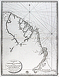 | Details | Depot de la Marine | 1817 |
| Mouth of the Amazon River with Coastal French Guiana and Suriname |
|
Depot de la Marine |
|
| 1817 |
| LOC:67 |
| $1,300.00 | Depot-de-la-Marine | Mouth-of-the-Amazon-River-with-Coastal-French-Guiana-and-Suriname |
Original 1817 French nautical chart titled Carte reduite des cotes de la Guyane comprises entre les bouches de la riviere des Amazones et celles du Maroni, issued by the Depot de la Marine. The chart depicts the mouth of the Amazon River from Rio Araguari southward and extends north along the coasts of Brazil into French Guiana and Suriname as far as the Maroni River. Engraved on thick chain-laid paper, the sheet bears the circular stamp of the French hydrographic service and reflects official early nineteenth century maritime survey work.<br><br>
The map records numerous coastal and riverine features, native villages, missionary sites, and geographic landmarks as known at the time. Place names include Cayenne, Kourou, St. Paul, Cape Orange, and Mt. Tripoupou, with interior village references near the Tumuk Humac mountains. Notation on the chart reflects the limited European penetration of the interior during this period, consistent with contemporary exploration accounts such as those of Alexander von Humboldt. Soundings, offshore islands, and coastal configuration are shown throughout, emphasizing navigational utility.<br><br>
Charts issued by the Depot de la Marine formed the core of French naval hydrography during the early nineteenth century and remain important records of Atlantic coastal surveying. Early examples in original state are increasingly scarce. This sheet offers documentary value for collectors focused on South American exploration, colonial maritime networks, and the technical development of European hydrographic mapping.<br><br> |
| 884 | 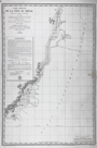 | Details | Depot de la Marine | 1824 |
| Antique chart of Brazilian east coast north of Cabo Frio |
|
Depot de la Marine |
|
| 1824 |
| LOC:67 |
| $500.00 | Depot-de-la-Marine | Antique-chart-of-Brazilian-east-coast-north-of-Cabo-Frio | Antique French sea chart issued in 1824 extends over approximately 800 miles of the east coast of Brazil and incudes portions of the State of Rio de Janeiro and the State of Espirito Santo. Coverage on this old chart starts about 80 miles to the east of Rio de Janeiro near Cabo Frio and trends generally north-northeast past Cabo de São Tomé, Vitoria, Rio Doce and Porto Seguro, ending north of Santo Andre. Little interior details are shown but the chart does identify several mountainous features that may have been visible from sea including the Pic ou Frade de Maccahe, Mt. de Campos, Mt. Mestre Alvaro, and Mont Pascoal.
<br></br>
Tracks are recorded for the two French vessels that conducted explorations and soundings of the area on this chart: the Corvette "la Bayadere" and the Brick "le Favori". Contains an avertissment below the title block with notes, warnings, and observations useful to mariners.
<br></br>
With the circular logo of the Depot Generale de la Marine. All text in French. No. 408. |
| 1036 | 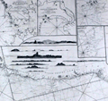 | Details | Norie, J.W. | 1836 |
| Huge 1830 Blueback Chart of the Coast of Brazil |
|
Norie, J.W. |
|
| 1836 |
| LOC:0 |
| $0.00 | Norie--J-W- | Huge-1830-Blueback-Chart-of-the-Coast-of-Brazil | SOLD
<br></br>
Spectacular six foot long antique blueback chart of the Brazilian Coast from 1836 first published in 1830. Updated with significant revisions based on of a chart by Steel & Co. in 1817. Contains nine attractive coastal elevation views and numerous inset harbor charts including:
<div class="indenttextblock">
<ul>
<span style= style="list-style-type: circle;">
<li>The Bay of Maranham</li>
<li>The Harbour of Pernambuco</li>
<li>The Harbour of Rio Grande</li>
<li> A Plan of the Harbour of Rio Janeiro </li>
<li>A Plan of Santos Harbor</li>
<li>The Bay of Espirito Santo</li>
<li> Plan of the ABROLHOS with the Track of Baron Roussin</li>
<li>Plan of Bahia of the Bay of All Saints</li>
<li>The Island of Fernand de Noronha</li>
</span>
</ul>
</div>
Attribution reads: " London, Published as the Act directs by J.W. Norie and Company August 24, 1830 at the Navigation Warehouse and Naval Academy, Number 157 Leadenhall Street. |
| 885 | 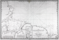 | Details | Depot de la Marine | 1842 |
| Antique chart of Brazilian coast and mouth of the Amazon River |
|
Depot de la Marine |
|
| 1842 |
| LOC:67 |
| $575.00 | Depot-de-la-Marine | Antique-chart-of-Brazilian-coast-and-mouth-of-the-Amazon-River | Antique French sea chart from 1842 covers the mouth of the <b>Amazon River</b> in Brazil. This fine large copper-plate engraved nautical chart begins north of the Amazon River near Isla Maraca and trends south then east to include Rio Araguari ( Araouari ) , Rio Amazonas, Ilha de Marajo, Para River, and the Ile de Maranham. Includes the towns of <b>Belem</b> (Para) , Sao Luis (San Luiz) , Macapa, Chaves, and numerous smaller villages. Includes an inset chart/plan of the Para River with Belem.
<br></br>
Dozens of smaller rivers and tributaries of the Amazon are identified by name along with hundreds of depth soundings in meters. After a lapse of 25 years France had recently re-adopted the metric system in 1837. At bottom left the authors provided a useful depth conversion table from meters to feet (pieds), and to the old measure of depth- brasses (about five feet).
<br></br>
With the circular logo of the <b>Depot Generale de la Marine</b>. All text in French. No. 408. |
| 2559 | 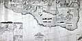 | Details | Laurie, Richard H. | 1870 |
| Huge fine antique blueback General Chart of the Coasts of Brazil |
|
Laurie, Richard H. |
|
| 1870 |
| LOC:1409 |
| $6,800.00 | Laurie--Richard-H- | Huge-fine-antique-blueback-General-Chart-of-the-Coasts-of-Brazil | Huge privately-published blueback chart of Brazil in fine condition. 3' 4" X 6' 4" in total size. Coverage extends from the estuary of the Amazon River in Brazil to the Plate River and Buenos Aires, Argentina. Numerous insets of harbors (eg. Rio de Janeiro, Pernambuco, San Salvador, ...) and elevation coastal views. By Richard H. Laurie. Dated within to 1870 and no later correction or issue dates mean this chart is truly from 1870. Rare, especially in this good condition.
<br></br>
Publishers' attribution at bottom reads: "London, Published by Richd. H. Laurie, No. 53 Fleet Street. January 1st 1870." Engraved by Alex Findlay.
<br></br>
Verso carries labels for both publisher (R.H. Laurie) and seller. Seller is Barber and Bustin, Successors to J.R. Cameron Chronometer, Watch, and Nautical Instrument Maker, 54 South Castle Street, Liverpool.
<br></br>
Note that the image is stitched together from 2 images. Any fuzziness you see near the title center is an artifact of the photo-stitching process. |