| | Thumbnail | | Creator | Date | Title / Author / Date / Location | Price | | | Description |
| 6653 | 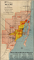 | Details | A.C. Douglass Printing Company | 1926 |
| 1926 Map of the City of Miami and Environs with Estimated Expansion |
|
A.C. Douglass Printing Company |
|
| 1926 |
| LOC:89 |
| $600.00 | A-C--Douglass-Printing-Company | 1926-Map-of-the-City-of-Miami-and-Environs-with-Estimated-Expansion | Interesting and prescient original lithographed map of the City of Miami and the nearby surrounding area made during the Miami land boom. The map shows forecasted expansive development between the period 1925 - 1935. Scarce.
<br><br>
Show Miami's historic growth from 1910 - 1925 and forecasts development to 1935 with projected future boundaries shown. Miami's boundary shows rapid population growth from 5,470 people in 1910, to 29,571 in 1920, and 225,000 in 1926, with the population projected to reach 1,000,000 by 1935.
<br><br>
Compiled and drawn by Sauer and Seghy. Printed by A.C. Douglass Printing Co., (2907 N.W. 12th Ave., Miami) in 1926.
<br><br>
Along with the usual suspects the map captures several lesser known historical features:
<div class="indenttextblocksingle">
<ul style="list-style-type: circle;">
<li>Irons Manor subdivision: The Irons Manor development was platted by developer V. Earl Irons in 1926 following the principles of the City Beautiful movement. </li>
<li>Miami Jockey Club: established in 1924 by James Bright, Glenn Curtis, and Joseph Smoot. </li>
<li>Hanson's avocado grove established by Edgar F. Hanson in 1922 was the largest in the world with over 30,000 avocado trees.</li>
<li>King Cole Hotel, with 60 rooms was completed in 1925.</li>
<li>Future site of the University of Miami, opened in fall 1926.</li>
</ul>
</div> |