| | Thumbnail | | Creator | Date | Title / Author / Date / Location | Price | | | Description |
| 2485 | 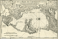 | Details | Anville, Jean Baptiste Bourguignon d' | 1730 |
| Fine antique plan of the Bay of Cartagena, Colombia |
|
Anville, Jean Baptiste Bourguignon d' |
|
| 1730 |
| LOC:5 |
| $700.00 | Anville--Jean-Baptiste-Bourguignon-d- | Fine-antique-plan-of-the-Bay-of-Cartagena--Colombia | Early and very scarce map of the area surrounding Cartagena, Colombia in northern South America. Hilly or mountainous areas are shown in relief. With depth soundings of the channel from Boca Chica into the inner harbor at Cartagena.
<br></br>
From Charlevoix's history of the Caribbean.
Noted features on this copper-plate engraved plan of Cartagena include
<div class="indenttextblock">
<ul style="list-style-type: circle;">
<li>La Cienega de Tesca</li>
<li>Mancanillo</li>
<li>La Madre de Popa ou Nuestra Senora de la Candelaria (a hilltop religious complex dating to 1607).</li>
<li>Boca Chica (entrance to Cartagena Bay)</li>
<li>La Isla de Varu</li>
<li>Paso a Caballos</li>
<li>Isla de Brugas</li>
<li>el Fuerte de Santa Cruz</li>
</ul>
</div> |
| 5462 | 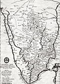 | Details | Anville, Jean Baptiste Bourguignon d' | 1737 |
| Original antique map of southern India and Coromandel Coast after Bouchet |
|
Anville, Jean Baptiste Bourguignon d' |
|
| 1737 |
| LOC: |
| $450.00 | Anville--Jean-Baptiste-Bourguignon-d- | Original-antique-map-of-southern-India-and-Coromandel-Coast-after-Bouchet | Early antique copper-plate engraved map from 1737 of <strong>southern India</strong> and a bit of Sri Lanka (Ceylan) including the <strong>Coromandel Coast</strong> of southeast India.
<br></br>
Created by J.B. d'Anville (1697-1782) after Jesuit cartographer Jean-Venant Bouchet who spent 30 years surveying southern India. Includes the Jesuit "logo" at bottom left, an acknowledgement of its Jesuit sources. Anville would have used the symbol to legitimize and to promote the value of this derivative work.
<br></br>
Engraved by Louis Corne. Apparently scarce. No copy found for sale online nor any sale record in AMPR.
<br></br>
This is one of the earliest maps to accurately detail the interior of Southern India. Legend at lower left identifies locations described in French as:
<div class="indenttextblocksingle">
<ul style="list-style-type: circle;">
<li>Place considerable</li>
<li>Demeure d'un Nabab ou Gouvereur.</li>
<li>Demure d'un Paleagaren ou petit Prince.</li>
<li>Eglise ou Christienti.</li>
<li>Pagode ou Temple de Gentile.</li>
</ul>
</div> |
| 5166 | 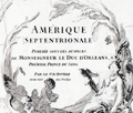 | Details | Anville, Jean Baptiste Bourguignon d' | 1746 |
| Antique French map of North America Amerique Septentrionale |
|
Anville, Jean Baptiste Bourguignon d' |
|
| 1746 |
| LOC:53 |
| $460.00 | Anville--Jean-Baptiste-Bourguignon-d- | Antique-French-map-of-North-America-Amerique-Septentrionale | Two joined sheets of D'Anville's four-sheet map of North America and the West Indies from 1746 (dated within). Much blank space west of the Mississippi River reflects the scarcity of information about the geography of Tecas (Texas) and most of the west United States save for that of the Spanish territories around New Mexico. D'Anville names and locates many native American tribes including the Chicachas, Canoatinos, the Cherakis, Iroquois, and Chetimachas (around Bayou Lafourche, Louisiana).
<br></br>
At upper left is an inset of Hudson Bay, Baffin Bay, Labrador, Baffin Bay, and Greenland.
<br></br>
Designed by Gravelot; engraved by Major. |
| 3631 | 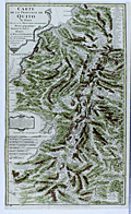 | Details | Anville, Jean Baptiste Bourguignon d' | 1751 |
| Mid eighteenth-century French map of the Province of Quito |
|
Anville, Jean Baptiste Bourguignon d' |
|
| 1751 |
| LOC:88 |
| $350.00 | Anville--Jean-Baptiste-Bourguignon-d- | Mid-eighteenth-century-French-map-of-the-Province-of-Quito | Fine example of the single sheet version of Pedro Vicente Maldonado's map of the Province of Quito, one of the most important regional maps of South America published in the 18th Century. Includes the triangular network of survey lines la Condamine utilized in his survey.
<br></br>
The map is a reduced version of Maldonado's 4 sheet map published in Paris in 1750. This single sheet version was incorporated in La Condamine's authoritative account of the Spanish-French Geodesic Mission to the area, often referred to as the "la Condamine expedition".
<br></br>
This map was drawn by Jean-Baptiste Bourguinon d'Anville, one of the most celebrated French cartographers, and engraved by Guillaume Delahaye. This map was commissioned by Mr. de la Condamine to be included in his Journal du voyage fait par ordre du roi à l'équateur, servant d'introduction historique à la 'Mesure des trois premiers degrés du méridien', which was published in Paris by l'Imprimerie Royale in 1751.
<br></br>
Focused on what is today Ecuador, the map extends from Jaen on the Rio Maranon in what is now northern Peru, all the way northwards to Popayan (Colombia), and runs from the Pacific coast over the Andes to include the upper reaches of the Amazon Basin. Includes important cities such as Quito, Guayaquil, Cuenca, Popayan and Esmereldas. This vast area was one of the most challenging in the world to map, as it included thousands of square miles of coastal plains, volcanic peaks, and swamps. |
| 4694 | 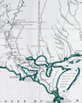 | Details | Anville, Jean Baptiste Bourguignon d' | 1752 |
| Carte De La Louisiane |
|
Anville, Jean Baptiste Bourguignon d' |
|
| 1752 |
| LOC:53 |
| $1,250.00 | Anville--Jean-Baptiste-Bourguignon-d- | Carte-De-La-Louisiane | Large, scarce antique map by d'Anville of the lower Mississippi, the Arkansas, the Red, the Osage, and lower Missouri rivers as well as much of the coast bordering on the Gulf of Mexico. States included in this copperplate-engraved French antique map are Texas, Louisiana, Mississippi, Alabama and Florida.
<br></br>
Large inset map of the Mississippi River system including the Illinois and Missouri Rivers with several French forts. Identifies locations of numerous native American Indian settlements including the Metchigamias, Caskakias, Osage, Kansez, Tapouchas, Chacchoumas, and Petits Akansas. The town of St. Louis, Missouri, not founded until 1763, is not shown but two references to the Cahokia Indians including an "Ancien Village des Caho." are identified.
<br></br>
This two-sheet map is sometimes found in separate sheets but here both sheets are joined together resulting in a large 37" wide image.
<br></br>
Points of interest include New Orleans, Pascagoula, Mobile, and Pensacola Bay (Baye de Ste. Marie de Galbes), and St. Josephs Bay. |
| 1109 | 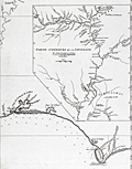 | Details | Anville, Jean Baptiste Bourguignon d' | 1752 |
| Partie Superieur de la Louisiane |
|
Anville, Jean Baptiste Bourguignon d' |
|
| 1752 |
| LOC:10 |
| $315.00 | Anville--Jean-Baptiste-Bourguignon-d- | Partie-Superieur-de-la-Louisiane | The east-most sheet of d'Anville's two-sheet map of the Texas, Louisiana, and Florida Gulf Coast. This sheet would have been joined to the western sheet to provide a complete map- "Carte de la Louisiane".
<br></br>
Coverage on this sheet extends from the Perdido River past Pensacola, Pensacola Bay ( Baye de St, Marie de Galbes ) Santa Rosa ( Sainte-Rose ) Island, St. Andrew Bay ( Baye de St. Andre ) and terminates just past Cape San Blas ( Cabo Escondido ) at the Appalachicola River. Includes part of the Alabama River ( Rio des Alibamons ) with Fort Toulouse (North of Montgomery, Alabama).
<br></br>
Large inset map of the Mississippi River system including the Illinois and Missouri Rivers with several french forts. Identifies locations of numerous native American Indian settlements including the Metchigamias, Caskakias, Osage, Kansez, Tapouchas, Chacchoumas, and Petits Akansas. The town of St. Louis, Missouri, not founded until 1763, is not shown but two references to the Cahokia Indians including an "Ancien Village des Caho." are identified. |
| 1173 | 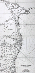 | Details | Anville, Jean Baptiste Bourguignon d' | 1753 |
| Antique Chart of The Coromandel Coast of India |
|
Anville, Jean Baptiste Bourguignon d' |
|
| 1753 |
| LOC:0 |
| $300.00 | Anville--Jean-Baptiste-Bourguignon-d- | Antique-Chart-of-The-Coromandel-Coast-of-India | Fine large antique French sea chart of India's Coromandel coast, the southeastern coastal region of the Indian Subcontinent, between the Eastern Ghats and the Bay of Bengal of the Indian Ocean. |