| | Thumbnail | | Creator | Date | Title / Author / Date / Location | Price | | | Description |
| 1131 | 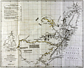 | Details | Arrrowsmith, John | 1832 |
| Antique map of southeast Australia with discoveries |
|
Arrrowsmith, John |
|
| 1832 |
| LOC:9 |
| $560.00 | Arrrowsmith--John | Antique-map-of-southeast-Australia-with-discoveries | SOLD
<br></br>
Scarce antique map by John Arrowsmith (1790-1873) is an early record of Australian history. The old map documented recent discoveries (as of 1832) in the interior of the southeastern portion of the continent of Australia. Coverage includes the Australian coastline from Brisbane to Adelaide (not named as it was not founded until 1836, 4 years after publication of this map).
<br></br>
Contains light outline color denoting tracks of exploration in the region between 1817 and 1829, and the miles explored by each. The explorers include: General Oxley, Lieutenant Currie, Mr. Hume, Mr. Allan Cunningham, and Captain Stuart.
<br></br>
Portions of the coast are denoted with dashed lines indicating that even by 1832 there were parts of the coast that were still poorly explored. Numerous notes about the character of the geography geology, and fauna of the region. For example Lake Alexandrina is described:
<div class="indenttextblock">
"The Lake is 50 miles long and 40 broad very shallow in some places, has several fine Bays, its water brackish it communications with Encounter Bay by a passage impracticable even for the smallest boats...The rise of the Tide does not exceed 8 inches."
</div>
<br />
Published in 1832 from London in Vol. 2 of the Journal of the Royal Geographical Society.
<br></br>
John Arrowsmith was a cartographer to both the Royal Geographical Society and the Parliamentary Reports. Those roles gave Arrowsmith access to information on the latest discoveries and he created numerous maps of Australia and other areas, revising the maps with results of later information. Published by John Murray, Albemarle Street. London. |
| 1122 | 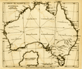 | Details | Arrrowsmith, John | 1838 |
| Australia according to the proposed divisions |
|
Arrrowsmith, John |
|
| 1838 |
| LOC:0 |
| $0.00 | Arrrowsmith--John | Australia-according-to-the-proposed-divisions | SOLD <br></br>
This small antique map by John Arrowsmith (1790-1873) is an early record of Australian history as it documents a proposed naming convention and geographical boundaries for states in the continent of Australia.
<br></br>
Published for the Journal of the Royal Geographical Society to accompany an article "Considerations on the Political Geography and Geographical Nomenclature of Australia".
<br></br>
These proposed states were geometric divisions of the continent, and did not take into account soil fertility, aridity or population. This meant that central and western Australia were divided into several states, despite their low populations both then and now.
<br></br>
<h3>Proposed Divisions of Australia</h3>
<br />
<div class="indenttextblock" style="list-style-type: circle;">
<ul>
<li>Dampiera</li>
<li>Victoria</li>
<li>Tasmania (not to be confused with the modern Tasmania).</li>
<li>Nuytsland</li>
<li>Carpentaria</li>
<li>Flindersland</li>
<li>Torresia</li>
<li>Cooksland</li>
<li>Guelphia</li>
<li>Vam Dieman's Land (modern-day Tasmania)</li>
</ul>
</div>
John Arrowsmith was a cartographer to both the Royal Geographical Society and the Parliamentary Reports. Those roles gave Arrowsmith access to information on the latest discoveries and he created numerous maps of Australia and other areas, revising the maps with results of later information. Published by John Murray, Albemarle Street. London. |