| | Thumbnail | | Creator | Date | Title / Author / Date / Location | Price | | | Description |
| 504 | 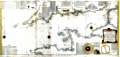 | Details | Beaurain, Jean | 1760 |
| Carte de la Manche |
|
Beaurain, Jean |
|
| 1760 |
| LOC:0 |
| $0.00 | Beaurain--Jean | Carte-de-la-Manche | SOLD<br></br>
Highly decorative chart of the English Channel by Jean Chevalier de Beaurain after the observations of Edmund Halley. Coverage includes from the Scilly Islands off the tip of Cornwall to past the Pas du Calais and Gravelines. At 42" in width this two sheet chart is an impressive artifact of a time when Britain ruled the waves. With three colored compass roses, rhumb lines, numerous soundings, and eight diagrams of maritime and navigational subjects.<BR> </BR>
Locates hundreds of towns and geographical landmarks on the South Coast of England and West Coast of France including Southampton, Poole, Cape Lizard, the Isle of Wight, Beachy Head, Plymouth, Brest; the Isles of Jersey, Guernsey, and Sark; Rouen, and Amiens. Dated 1760 in a decorative cartouche covered in roses.<BR> </BR>
Clockwise from the top left are a number of insets containing nautical definitions and drawings including: <BR>
-The offshore and tidal currents and their visual representation on the chart with arrows.<BR>
-Ancient and modern nautical logs (used to approximate the speed of a vessel over water).<BR>
-The use of the mariner's cross staff (l'Arbalestre) for measuring the altitude of the sun.<BR>
-The ship's wake or 'sillage'.<BR>
-The sounding lead (la sonde) for measuring water depth and the composition of the sea floor.<BR>
-The planisphere and a description of the earth's rotation.<BR>
-A simple astrolabe.<BR>
-The compass and compass card.<BR>
Martinet Inv; Vallet Script. |