| | Thumbnail | | Creator | Date | Title / Author / Date / Location | Price | | | Description |
| 757 | 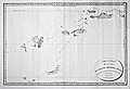 | Details | Beautemps-Beaupre, Charles-Francois | 1793 |
| Carte Generale de la Partie du Grand Archipel d'Asie |
|
Beautemps-Beaupre, Charles-Francois |
|
| 1793 |
| LOC:59 |
| $2,550.00 | Beautemps-Beaupre--Charles-Francois | Carte-Generale-de-la-Partie-du-Grand-Archipel-d-Asie | The Singapore Library web site sums up the significance of this scarce map of Asia: "Map of Indonesia showing tracks of Recherche and Esperance in 1792-1793. This map is part of the great archipelago of Asia, recognized by Rear Admiral Bruny-Dentrecasteaux, in 1792 and 1793" (1). This very scarce copper-plate engraved map is by Charles-François Beautemps-Beaupré (1766-1854). Charts by Beautemps-Beaupre are scarce. Only one other instance of this map is found in the AMPR.
<br></br>
On thick wove paper.
<br></br>
Chart of the waters and islands lying to the north of Australia including portions of the Ceram Sea, Arafura Sea, Banda Sea, and Molucca Sea, Key geographical features include a passage labeled "Dampier Strait", Waigeo ( Waigiou ), Batanta, Ceram, Ambon, Northern New Guinea, and Sulawesi ( Celebes ) and Timor. Much of the coastline of these islands is left blank because as of 1793 they were still uncharted and unexplored.
<br></br>
The map shows the track of two ships, the Recherche and Espérance , as they conducted an expedition (1791 - 1793) led by French Rear-Admiral Antoine Raymond Joseph de Bruni d'Entrecasteaux to find the missing ships of Jean-François de La Pérouse of whom nothing had been heard since March 1788.
<br></br>
C.F. Beautemps-Beaupre was one of the earliest hydrographers to use isobaths to represent water depth. Beautemp-Beaupres' many contributions to hydrography and his dedication to his profession is the reason he is sometimes referred to as the 'father of French hydrography'.
<br></br>
(1) Source online: http://eresources.nlb.gov.sg/printheritage/detail/61fb49ca-26e8-49cb-8e93-5f3558b123d2.aspx |
| 34 |  | Details | Beautemps-Beaupre, Charles-Francois | 1820 |
| Reconnoissance Hydrographique de la Cote Nord de France, Dunkerque |
|
Beautemps-Beaupre, Charles-Francois |
|
| 1820 |
| LOC:0 |
| $575.00 | Beautemps-Beaupre--Charles-Francois | Reconnoissance-Hydrographique-de-la-Cote-Nord-de-France--Dunkerque | This large-scale antique hydrographic chart of the town and environs of Gravelines is a fine example of the work of Charles-François Beautemps-Beaupré (1766-1854). Beautemps-Beaupre was one of the earliest hydrographers to use isobaths to represent water depth. In this chart he uses differently colored isobaths to represent three depth categories : less than 10 feet ; between 10 and 16 feet; and between 17 and 24 feet. This detail along with numerous soundings demonstrates Beautemp-Beaupre's dedication to his profession, and is the reason he is sometimes referred to as the 'father of French hydrography'.
<br><br/>
Date of 1802 is consistent with a dedication to vice-admiral F.E. de Rosily who served as Directeur of the Depot Generale de la Marine from 1795-1805. |
| 35 |  | Details | Beautemps-Beaupre, Charles-Francois | 1820 |
| Dunkerque |
|
Beautemps-Beaupre, Charles-Francois |
|
| 1820 |
| LOC:0 |
| $975.00 | Beautemps-Beaupre--Charles-Francois | Dunkerque | This scarce large-scale antique hydrographic chart of the town and environs of Dunkirk is a fine example of the work of Charles-François Beautemps-Beaupré, often referred to as the "Father of French Hydrography". Covering a stretch of coast from Mardick to Zuycoote the chart is focused almost entirely on the offshore areas.
<BR> </BR>
Beautemps-Beaupré (1766-1854), considered to be the father of modern French hydrography, was one of the earliest hydrographers to use colored isobaths to represent water depth. In this carefully colored chart he uses differently colored isobaths (light orange tones) to represent three depth categories : less than 10 feet ; between 10 and 16 feet; and between 17 and 24 feet. This detail along with hundreds of soundings demonstrates Beautemp-Beaupres' dedication to his profession.
<BR> </BR>
Not dated but another example from same series is dated to 1802. This fine example was likely published ca 1820 as part of "Le Pilote Francais", Beautemps-Beaupre's six folio-volume atlas comprised of 613 sheets of charts and plans. With the logo of the French Depot de la Marine. |
| 36 | 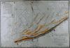 | Details | Beautemps-Beaupre, Charles-Francois | 1820 |
| Reconnoissance Hydrographique de la Cote Nord de France |
|
Beautemps-Beaupre, Charles-Francois |
|
| 1820 |
| LOC:0 |
| $0.00 | Beautemps-Beaupre--Charles-Francois | Reconnoissance-Hydrographique-de-la-Cote-Nord-de-France | SOLD<br></br>
Attractive large-scale antique copper-plate hydrographic chart of the French coast from Gravelines to Ostende by Charles-François Beautemps-Beaupré. Oriented with North at top of page indicated by a large compass circle (with shadow); surveyors lines and several sets of rhumb lines.
<BR> </BR>
Beautemps-Beaupre (1766-1854) was one of the earliest hydrographers to use isobaths to represent water depth. In this carefully colored chart he uses differently colored isobaths (light orange tones) to represent three depth categories : less than 10 feet ; between 10 and 16 feet; and between 17 and 24 feet. This detail along with hundreds of soundings demonstrates Beautemp-Beaupres' dedication to his profession, and suggests why he is considered by some to be the father of French hydrography.
<BR> </BR> |