| | Thumbnail | | Creator | Date | Title / Author / Date / Location | Price | | | Description |
| 4750 | 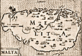 | Details | Bertius, Petrus | 1603 |
| 16th century map of Malta |
|
Bertius, Petrus |
|
| 1603 |
| LOC:77 |
| $380.00 | Bertius--Petrus | 16th-century-map-of-Malta | Attractive antique copper engraved map of the island of Malta (Melita), by Petrus Bertius. Contains a small vignette of St. Paul's shipwreck on the north of the island.
<br></br>
From "Tabularum Geographicarum Contractarum Libri Quinque", the finest and most important edition of the "Caert Thresoor", the famous miniature atlas of Barent Langenes, 1598.
<br></br>
The map is engraved by Petrus Koerius , or Pieter Van Den Keere (1571-1646). Amsterdam: Cornelium Nicolai; Latin edition of 1603. |
| 1332 | 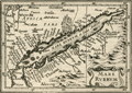 | Details | Bertius, Petrus | 1609 |
| Antique map of the Red Sea and Arabia |
|
Bertius, Petrus |
|
| 1609 |
| LOC:0 |
| $0.00 | Bertius--Petrus | Antique-map-of-the-Red-Sea-and-Arabia | SOLD<br></br>Fine small antique map of the Red Sea, Saudi Arabia, Aden, Yemen,and Egypt. This attractive copperplate engraved map covers numerous islands and villages including Aden, Suez, Mecca (Mecha), and Medina. By Petrus Bertius ca 1609. Text on verso is in French. |
| 5237 | 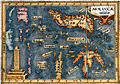 | Details | Bertius, Petrus | 1609 |
| Antique map of the East Indies or Moluccas |
|
Bertius, Petrus |
|
| 1609 |
| LOC:6 |
| $190.00 | Bertius--Petrus | Antique-map-of-the-East-Indies-or-Moluccas | Interesting original miniature antique map of the Maluku Archipelago or Moluccas near the Banda Sea ca. 1609 by Petrus Bertius. Includes Sulawesi, Timor, Seram and numerous other islands in the Malaku province of Indonesia. |
| 6515 | 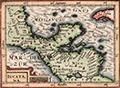 | Details | Bertius, Petrus | 1616 |
| Fine 1616 map of Mexico, Yucatan, Nicaragua and offshore islands |
|
Bertius, Petrus |
|
| 1616 |
| LOC:78 |
| $275.00 | Bertius--Petrus | Fine-1616-map-of-Mexico--Yucatan--Nicaragua-and-offshore-islands | Attractive original engraved map of the Yucatan Peninsula (Iucatana), Southern Mexico and Nicaragua by Petrus Bertius.
<br><br>
Petrus Bertius' 1616 map of the Yucatan Peninsula (Iucatana) and a portion of Central America is hand colored with attractive hachuring in the oceans that provides an interesting dimensionality to this scarce artifact.
<br><br>
Very scarce original reduced-size version created by Bertius in 1616 to meet the demands of a growing and cost conscious market. This very fine map covers a wide area that includes the western portion of Cuba, northern Nicaragua, Honduras, the Yucatan Peninsula and southern Mexico (Nova Hispanie Pars). |
| 650 | 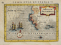 | Details | Bertius, Petrus | 1616 |
| Spitsbergen, Norway |
|
Bertius, Petrus |
|
| 1616 |
| LOC:0 |
| $0.00 | Bertius--Petrus | Spitsbergen--Norway | <br></br>
SOLD
<br></br>
Small decorative antique copperplate map of Spitsbergen, Norway by Petrus Bertius (1565-1629), a professor of mathematics and librarian from Holland. With two sailing vessels underway and penguins cavorting offshore in 'Oceanus Septentrionalis' (Northern Ocean) .
<br></br>
Probably from ''Tabularum geographicarum contractarum...' published by Jodocus Hondius in 1616. Latin text on verso. Page 60. |
| 4696 | 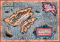 | Details | Bertius, Petrus | 1616 |
| Descriptio Maioricae et Minoricae |
|
Bertius, Petrus |
|
| 1616 |
| LOC:13 |
| $350.00 | Bertius--Petrus | Descriptio-Maioricae-et-Minoricae | Colorful miniature antique map of the <b>Balearic Islands</b> (Baleares) of Majorca and Minorca, Spain in the Mediterranean Sea. This lovely copper-plate engraved map is from a Latin edition of Petrus Bertius' <b>Tabularum Geographicarum Contractarum</b>. The basis of the "Tabularum" was the atlas Caert Thresoor by Barent Langenes, first published in 1598. Key named features include Porto Pin, Calafigur, Calalonga, Menacor, Cabo Formentelli, Porto Fornelle, and San Catharina.
<br></br>
Sea monsters and a lateen-rigged sailing ship beautifully decorate the map while filling empty areas in the sea. In the crow's nest high above the deck a sailor is depicted throwing objects overboard, a detail perhaps related to a ritual of good fortune.
<br></br>
Latin text on verso. |
| 5196 | 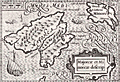 | Details | Bertius, Petrus | 1616 |
| Majorcae Et Minorcae Descrip |
|
Bertius, Petrus |
|
| 1616 |
| LOC:77 |
| $325.00 | Bertius--Petrus | Majorcae-Et-Minorcae-Descrip | Uncolored miniature antique map of the <b>Balearic Islands</b> (Baleares) of Majorca and Minorca, Spain in the Mediterranean Sea. Key named features include Porto Pin, Calafigur, Calalonga, Menacor, Cabo Formentelli, Porto Fornelle, and San Catharina. Sea monsters and a lateen-rigged sailing ship beautifully decorate the map while filling empty areas in the sea. In the crow's nest high above the deck a sailor is depicted throwing objects overboard, a detail perhaps related to a ritual of good fortune.
<br></br>
This fine copper-plate engraved map of Mallorca from a <b>French edition</b> of Petrus Bertius' <b>Tabularum Geographicarum Contractarum</b>. The basis of the "Tabularum" was the atlas Caert Thresoor by Barent Langenes, first published in 1598.
<br></br>
French text on verso.
<br></br>
[ Mallorca, Majorca, Majorcae, Minorca, Menorca, Minorcae ] |
| 4700 | 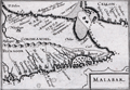 | Details | Bertius, Petrus | 1616 |
| Malabar |
|
Bertius, Petrus |
|
| 1616 |
| LOC:13 |
| $225.00 | Bertius--Petrus | Malabar | Very beautiful early antique miniature map of southern India and a part of Sri Lanka (Ceilon or Ceylon) by Bertius. Numerous towns and villages in India are identified. Important locations within India that are noted by Bertius include: Coromandel, Bisnagor, Goa, Negapatam, Cananor, Calicut (Kozhikode), and Mangalor (Mangaluru),
<br></br>
This lovely copper-plate engraved map is from a Latin edition of Petrus Bertius' <b>Tabularum Geographicarum Contractarum</b>. The basis of the "Tabularum" was the atlas Caert Thresoor by Barent Langenes, first published in 1598.
<br></br>
Latin text on verso. Plate 586. |
| 1074 | 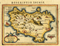 | Details | Bertius, Petrus | 1616 |
| Antique map of the island of Ischia in the Bay of Naples |
|
Bertius, Petrus |
|
| 1616 |
| LOC:4 |
| $150.00 | Bertius--Petrus | Antique-map-of-the-island-of-Ischia-in-the-Bay-of-Naples | Small detailed, 400 year-old map of the volcanic island of Ischia which lies off the coast of Naples, Italy. Ischia is the largest of three islands that lie in or near the Gulf of Naples: Ischia, Capri, and Procida. At the east end of the island is shown the Aragonese Castle built in the year 474.
<br></br>
From the Latin edition of Bertius' 'Tabularum geographicarum contractarum..' |