| | Thumbnail | | Creator | Date | Title / Author / Date / Location | Price | | | Description |
| 6701 | 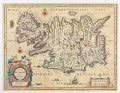 | Details | Blaeu, William Janszoon | 1650 |
| Tabula Islandiae Auctore Georgio Carolo Flandro |
|
Blaeu, William Janszoon |
|
| 1650 |
| LOC:86 |
| $700.00 | Blaeu--William-Janszoon | Tabula-Islandiae-Auctore-Georgio-Carolo-Flandro | A fine 17th century map of Iceland priced to sell.
<br><br>
This map of Iceland, "Tabula Islandiae Auctore Georgio Carolo Flandro", was engraved for William Janszoon Blaeu and first published in his firm’s Atlas Novus. The plate is based on surveys by the Dutch navigator Georgius Carolus Flandrus (Joris Carolus), one of the few early European seafarers to chart northern waters. The map depicts Iceland with stylized mountain ranges, rivers, and settlements identified in Latin and Icelandic. Surrounding seas are filled with ships and sea creatures, and a large title cartouche occupies the lower right. The imprint “Guiljelmus Blaeuw” identifies the plate as one originally engraved for Willem before his death in 1638.
<br><br>
The verso text, printed in Dutch, places this example within the early Dutch-language edition of the Toonneel des Aerdrycks issued in Amsterdam around 1648–1650, when the Blaeu firm was transitioning from William to his son Joan. Printed from the original copperplate, this state retains the strong, clean impression of the earliest issues and represents one of the most well known mid seventeenth-century maps of Iceland. The map’s enduring design remained in use for more than two decades and set the cartographic standard for the island until the late eighteenth century.
<br><br> |
| 755 | 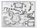 | Details | Blaeu, William Janszoon | 1650 |
| Venezuela cum parte Australi Novae Andalusiae |
|
Blaeu, William Janszoon |
|
| 1650 |
| LOC:200 |
| $695.00 | Blaeu--William-Janszoon | Venezuela-cum-parte-Australi-Novae-Andalusiae | Antique map of Venezuela with the Leeward Antilles and the Windward Islands from the Latin edition of William Blaeu's "Le theatre du monde, ou Nouvel atlas" published in Amsterdam ca. 1650. Islands (not engraved to scale, apparently) include from west to east: Aruba, Curacao, Bonaire, los Rocques, las Aves, la Orchilla, Tortuga, la Blanquilla, Margarita, Grenada, Trinidad, Tobago, , St. Vincent , St. Lucia, Martinique, and Dominica.
<br></br>
Geographic coverage includes the Gulf of Paria, Nuestra Senora de los Remedios, Provincia de los Caracas, Nueva Valencia, Portilla de Carara, Maracapana, Nuestra Senora de Carvalleda, St. Iago de Leon, Nueva Segovia, and the settlement of St. Thomas along the lower Orinoco River.
<br></br>
Cartographic elements include mountains, forests, locations of settlements, bays, and rivers, degrees of latitude and longitude, two compass roses oriented with North at top of plate, and numerous topographical details. Decorative elements include birds, ship, sheep, angels, and monkeys. With two decorative scrollwork cartouches.
<br></br>
This map is one of five maps of South America in Blaeu's atlas which are taken from other Dutch sources. The plates for this map were originally made by the younger Jodocus Hondius sometime before his death in 1629. Hondius' plates were bought by Willem Janszoon Blaeu who replaced Hondius' name with his own. Single vertical fold, as issued. |