| | Thumbnail | | Creator | Date | Title / Author / Date / Location | Price | | | Description |
| 30 |  | Details | Blondeau, Alexandre | 1820 |
| Carte de la partie de la Cote Nord-Ouest de L'Amerique |
|
Blondeau, Alexandre |
|
| 1820 |
| LOC:63 |
| $400.00 | Blondeau--Alexandre | Carte-de-la-partie-de-la-Cote-Nord-Ouest-de-L-Amerique | French copy of Vancouver's nautical chart of West North American coast from Alaska to Mexico. By Blondeau. Elsewhere attributed to Depot de la Marine but that is doubtful. Tracks of Vancouver's vessels, mountain ranges, missions, anchorages and a few soundings are clearly delineated.<BR> </BR>
Highly detailed (get a magnifier and enjoy) antique chart coverage extends down the coast from Kodiak Island, Alaska though Prince William sound, Port San Francisco and St. Diego California, into Mexico- Baie do Todos Santos, Baie de las Virgines, and ends near a marked anchorage near a mission 'St. Domingo'. California is described as "Nouvelle Albion".<BR> </BR> <BR> </BR>
Engraved and lettered by Blondeau: "Ecrit par M. Blondeau. Grave par Blondeau Rue et Porte St Jacques No 85." |
| 718 | 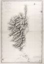 | Details | Blondeau, Alexandre | 1831 |
| Antique French Sea Chart of Corsica |
|
Blondeau, Alexandre |
|
| 1831 |
| LOC:66 |
| $850.00 | Blondeau--Alexandre | Antique-French-Sea-Chart-of-Corsica | Large antique copper-plate engraved nautical chart of the French island of Corsica ( Corse )and nearby islands: Isle of Asinara, Bonifacio Strait, Capraia Island, Elba ( Elbe ), and northern Sardinia ( Sardaigne ). Coverage includes the towns of Bonifacio, Ajaccio ( the birthplace of Napoleon Bonaparte ), Calvi, Ile Rousse, St Florent, Port Vecchio, and many more.
<br></br>
This splendid original French sea chart is a fine example of mid eighteenth-century nautical cartography. A heavy impression and admirable detailed engraving of the mountainous relief of the island are accompanied by a wealth of detail not only of the coastal regions but inland as well.
<br></br>
Issued by the French Depot Generale de la Marine in 1831 (dated within) after surveys by the Depot de la Guerre in 1824, and by Captain Hell in 1822, 1823, and 1824. Engraved by Alexandre Blondeau of France's Depot de la Guerre. At bottom right is the circular logo with anchor of the Depot General de la Marine. Number 232. Price when issued two Francs. |
| 751 | 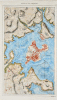 | Details | Blondeau, Alexandre | 1837 |
| Boston and Vicinity |
|
Blondeau, Alexandre |
|
| 1837 |
| LOC:0 |
| $0.00 | Blondeau--Alexandre | Boston-and-Vicinity | SOLD<br></br>
Antique steel engraving titled "Boston et ses Environs" - Boston and vicinity. Includes outlying towns of Roxbury, Dorchester, Cambridge and Charles Town. This early hand-colored map of the city, at that time largely located on only the Shawmut Peninsula, makes it clear just how much of Boston's current land area is the result of landfill and reclamation. It is said that upwards of 65% of Boston's land area did not exist when the city was founded around 1630.
<br></br>
From 1st edition of Jean B.G. Roux de Rochelle's Etats-Unis d'Amérique. Paris: Firmin Didot Freres. Plate number 45. |