| | Thumbnail | | Creator | Date | Title / Author / Date / Location | Price | | | Description |
| 1293 | 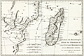 | Details | Bonne, Rigobert | 1774 |
| Antique map of East Africa and Madagascar |
|
Bonne, Rigobert |
|
| 1774 |
| LOC:0 |
| $0.00 | Bonne--Rigobert | Antique-map-of-East-Africa-and-Madagascar | SOLD<br></br>
Antique copper-plate engraved map of East Africa, Madagascar, and the Comoros Islands engraved by Andre' and issued by Rigobert Bonne in 1774. Number 96.
<br></br>
Rigobert Bonne was the successor to Jacques Nicolas Bellin as Royal Cartographer to France in the office of the Hydrographer at the Depôt de la Marine. |
| 1242 | 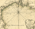 | Details | Bonne, Rigobert | 1778 |
| Miniature antique nautical chart of the Gulf of Lyon |
|
Bonne, Rigobert |
|
| 1778 |
| LOC:7 |
| $135.00 | Bonne--Rigobert | Miniature-antique-nautical-chart-of-the-Gulf-of-Lyon | Fine miniature antique nautical chart of the Gulf of Lyon and the French coast of the regions of <b>Provence and Languedoc-Roussillon</b>. Numerous towns and villages are identified by name, including Perpignan, Narbonne, Beziers, Agde, Sete (Cette), Montpellier, Arles, Aix, la Ciotat, Cassis, and Marseilles. The chart ends to the east near the resort town of Six Fours les Plages. Small coverage of Spain includes Roses.
<br></br>
Despite its small size this scarce miniature engraving contains most features that appear on larger sea charts- numerous depth soundings are provided; navigational hazards and sand banks are clearly identified; and rhumb lines are provided with a 18 degree compass adjustment for magnetic variation. Bonne provides very little detail about the interior topography.
<br></br>
From Rigobert Bonne's miniature nautical atlas "Atlas maritime ou Cartes réduites de toutes les Côtes de France avec des cartes particulières des isles voisines les plus considérables, suivies des plans des principales villes maritimes de ce royaume." One of 12 charts of France published in the Atlas Maritime which are considered to among the very few miniature nautical charts published during the golden age of miniature maps . Published by Lattre from Paris. With the royal privilege. No. 2.
<br></br>
Rigobert Bonne (1727-1794) was the successor to Jacques Nicolas Bellin as Royal Cartographer to France in the office of the Hydrographer at the Depôt de la Marine. Bonne first came to prominence when he published a number of charts in the Atlas Maritime in 1762. |
| 1252 | 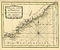 | Details | Bonne, Rigobert | 1778 |
| Antique miniature chart of the coast near Provence, France |
|
Bonne, Rigobert |
|
| 1778 |
| LOC:7 |
| $185.00 | Bonne--Rigobert | Antique-miniature-chart-of-the-coast-near-Provence--France | Fine antique miniature nautical chart of the <b>Provencal Coast</b> of France on the Mediterranean Sea. Coverage includes the villages of Toulon, St. Tropez, Cannes, Antibes, Ventimille, Oneille, Albinga, Genes, and the Principality of Monaco.
<br></br>
From Rigobert Bonne's miniature nautical atlas "Atlas maritime ou Cartes réduites de toutes les Côtes de France avec des cartes particulières des isles voisines les plus considérables, suivies des plans des principales villes maritimes de ce royaume." One of 12 charts published in the Atlas Maritime which are considered to among the very few miniature nautical charts published during the golden age of miniature maps . Published by Lattre from Paris. With the royal privilege. No. 9.
<br></br>
This scarce miniature copper-plate engraving contains much of the same information found on larger charts- rhumb lines; an adjustment for magnetic variation; depth soundings that are numerous; headlands, capes, navigation hazards and sand banks that are clearly identified.
<br></br>
Rigobert Bonne (1727-1794) was the successor to Jacques Nicolas Bellin as Royal Cartographer to France in the office of the Hydrographer at the Depôt de la Marine. Bonne first came to prominence when he published a number of charts in the Atlas Maritime in 1762. He is better known for later publications, including the Atlas Encyclopedique, which he collaborated on with Nicholas Desmarest, as well as the maps he produced for Raynal's Atlas de Toutes Les Parties Connues du Globe Terrestre, which was published in 1780. |
| 1233 | 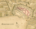 | Details | Bonne, Rigobert | 1778 |
| Scarce antique miniature plan of Toulon, France |
|
Bonne, Rigobert |
|
| 1778 |
| LOC:7 |
| $90.00 | Bonne--Rigobert | Scarce-antique-miniature-plan-of-Toulon--France | Scarce miniature plan of the fortified port city of Toulon, France, the chief base for France's large naval fleet the Vaisseaux de Guerre. Toulon lies along the Mediterranean coast in the Provence region of southern France. This small (4 1/2 " x 3 1/2 ") antique engraved plan of Toulon shows Vauban-style defensive walls around the city as well as the old harbor "vieille darce" (built 1604 - 1610) and the new harbor or "nouvelle darce". Maps the roads connecting to Toulon.
<br></br>
In a brief description of Toulon at the end of the atlas Bonne wrote:
<div class="indenttextblock">
Toulon, assez grande Ville et Port de Mer en Provence, est dans une situation admirable. Des Montagnes eleves jusquaux nues la couvrent au Septentrion et rendent son Port, qui est fort grand, une des plus sur de la Mediterranee. Ce Port, destine aux Vaisseaux de guerre, est une des plus connus de l'Europe; le entre est defendue par nombre de batteries et par plusieurs forts…"
</div>
<br />
From Rigobert Bonne's miniature nautical atlas "Atlas maritime ou Cartes réduites de toutes les Côtes de France avec des cartes particulières des isles voisines les plus considérables, suivies des plans des principales villes maritimes de ce royaume." Published by Lattre from Paris. With the royal privilege. No. 30.
<br></br>
Bonne attributes the source the of plans to three others: "… des belles Vues de nos Ports, que donnent M.M. Cochin et Les Bas, d'apres les excellens Tableaux de M. Vernet." |
| 1271 | 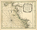 | Details | Bonne, Rigobert | 1778 |
| Antique miniature chart of the French coast at the Bay of Biscay |
|
Bonne, Rigobert |
|
| 1778 |
| LOC:0 |
| $0.00 | Bonne--Rigobert | Antique-miniature-chart-of-the-French-coast-at-the-Bay-of-Biscay | SOLD
<br></br>
Fine antique French miniature nautical chart of the French coast on the <b>Bay of Biscay</b> or Golfe de Gascogne (Fr.) (also Golfo de Biscaia or Gollfo de Vizcaya (Sp.)) in the provinces of Poitou, Aunis, and Brittany (Bretagne). Coverage includes the Quiberon Peninsula, Belle Isle, Nantes, Ile de Re, la Rochelle, Rochefort, mouth of the Loire River, and the Ile de Oleron.
<br></br>
From Rigobert Bonne's miniature nautical atlas "Atlas maritime ou Cartes réduites de toutes les Côtes de France avec des cartes particulières des isles voisines les plus considérables, suivies des plans des principales villes maritimes de ce royaume." One of 12 charts published in the Atlas Maritime which are considered to among the very few miniature nautical charts published during the golden age of miniature maps . Published by Lattre from Paris. With the royal privilege. No. 5.
<br></br>
This scarce miniature copper-plate engraving contains much of the same information found on larger nautical charts- rhumb lines; an adjustment for magnetic variation; numerous depth soundings; anchorages, headlands, capes, navigation hazards and sand banks that are clearly identified.
<br></br>
Rigobert Bonne (1727-1794) was the successor to Jacques Nicolas Bellin as Royal Cartographer to France in the office of the Hydrographer at the Depôt de la Marine. Bonne first came to prominence when he published a number of charts in the Atlas Maritime in 1762. He is better known for later publications, including the Atlas Encyclopedique, which he collaborated on with Nicholas Desmarest, as well as the maps he produced for Raynal's Atlas de Toutes Les Parties Connues du Globe Terrestre, which was published in 1780. |
| 1238 | 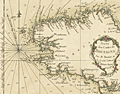 | Details | Bonne, Rigobert | 1778 |
| Antique miniature nautical chart of Brittany, France |
|
Bonne, Rigobert |
|
| 1778 |
| LOC:0 |
| $0.00 | Bonne--Rigobert | Antique-miniature-nautical-chart-of-Brittany--France | SOLD
<br></br>
Fine antique miniature nautical chart of the coast of <b>Brittany, France</b> (Bretagne) in the northwest of that country. Coverage on this attractive miniature sea chart includes Île-de-Bréhat, Morlaix, Ushant, Brest, l'Orient, Port Louis, and Quiberon.
<br></br>
Despite its small size this scarce copper-plate engraving contains much of what is found on larger charts- numerous headlands are noted; depth soundings are provided; hazards and sand banks are clearly identified; and rhumb lines are provided with a 19 degree compass adjustment for magnetic variation. Unlike other charts in the series, on this particular miniature chart Bonne provides very little detail about the interior topography and geography of Brittany.
<br></br>
From Rigobert Bonne's miniature nautical atlas "Atlas maritime ou Cartes réduites de toutes les Côtes de France avec des cartes particulières des isles voisines les plus considérables, suivies des plans des principales villes maritimes de ce royaume." One of 12 charts published in the Atlas Maritime which are considered to among the very few miniature nautical charts published during the golden age of miniature maps . Published by Lattre from Paris. With the royal privilege. No. 4.
<br></br>
Rigobert Bonne (1727-1794) was the successor to Jacques Nicolas Bellin as Royal Cartographer to France in the office of the Hydrographer at the Depôt de la Marine. Bonne first came to prominence when he published a number of charts in the Atlas Maritime in 1762. He is better known for later publications, including the Atlas Encyclopedique, which he collaborated on with Nicholas Desmarest, as well as the maps he produced for Raynal's Atlas de Toutes Les Parties Connues du Globe Terrestre, which was published in 1780. |
| 1234 | 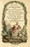 | Details | Bonne, Rigobert | 1778 |
| Antique title page to the miniature Atlas Maritime |
|
Bonne, Rigobert |
|
| 1778 |
| LOC:7 |
| $200.00 | Bonne--Rigobert | Antique-title-page-to-the-miniature-Atlas-Maritime | Scarce antique miniature title page to Rigobert Bonne's miniature sea atlas of coastal France. Bonne's scarce atlas contained 12 miniature nautical charts of coastal France and 18 miniature plates of port and harbor plans. With Table of Contents, colored attractive frontispiecce, and end notes.
<br></br>
From Rigobert Bonne's miniature nautical atlas "Atlas maritime ou Cartes réduites de toutes les Côtes de France avec des cartes particulières des isles voisines les plus considérables, suivies des plans des principales villes maritimes de ce royaume." Published by Lattre from Paris. With the royal privilege. Engraved by Monnet after a design by L. Legrand.
<br></br>
Rigobert Bonne was the successor to Jacques Nicolas Bellin as Royal Cartographer to France in the office of the Hydrographer at the Depôt de la Marine. |
| 3677 | 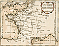 | Details | Bonne, Rigobert | 1778 |
| Antique master or key chart to the Petit Atlas Maritime |
|
Bonne, Rigobert |
|
| 1778 |
| LOC:7 |
| $160.00 | Bonne--Rigobert | Antique-master-or-key-chart-to-the-Petit-Atlas-Maritime | Scarce antique miniature master page to Rigobert Bonne's miniature sea atlas of coastal France. Bonne's scarce atlas contained 12 miniature nautical charts of coastal France and 18 miniature plates of port and harbor plans. On this master map nine rectangles show the viewer the area encompassed by each of Bonne's nine charts as shown in our inventory.
<br></br>
From Rigobert Bonne's miniature nautical atlas "Atlas maritime ou Cartes réduites de toutes les Côtes de France avec des cartes particulières des isles voisines les plus considérables, suivies des plans des principales villes maritimes de ce royaume." Published by Lattre from Paris. With the royal privilege. Engraved by Monnet after a design by L. Legrand.
<br></br>
Rigobert Bonne was the successor to Jacques Nicolas Bellin as Royal Cartographer to France in the office of the Hydrographer at the Depôt de la Marine. |
| 1237 | 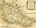 | Details | Bonne, Rigobert | 1778 |
| Antique miniature nautical chart of Belle Ile, France |
|
Bonne, Rigobert |
|
| 1778 |
| LOC:0 |
| $0.00 | Bonne--Rigobert | Antique-miniature-nautical-chart-of-Belle-Ile--France | SOLD
<br></br>
Fine antique miniature nautical chart of <b>Belle Île</b> (Belle-Isle), France in the English Channel off the French coast of Brittany. Coverage on this attractive miniature sea chart includes geographical and topographical detail within the four communes of Sauzon, Bangor, Le Palais, and Locmaria (Lomaria).
<br></br>
Despite its small size this scarce copper-plate engraving contains much of what is found on larger charts- numerous headlands are noted; depth soundings are numerous; hazards and sand banks are clearly identified; and rhumb lines are provided with a compass adjustment for magnetic variation.
<br></br>
From Rigobert Bonne's miniature nautical atlas "Atlas maritime ou Cartes réduites de toutes les Côtes de France avec des cartes particulières des isles voisines les plus considérables, suivies des plans des principales villes maritimes de ce royaume." One of 12 charts published in the Atlas Maritime which are considered to among the very few miniature nautical charts published during the golden age of miniature maps . Published by Lattre from Paris. With the royal privilege. No. 11.
<br></br>
Rigobert Bonne (1727-1794) was the successor to Jacques Nicolas Bellin as Royal Cartographer to France in the office of the Hydrographer at the Depôt de la Marine. Bonne first came to prominence when he published a number of charts in the Atlas Maritime in 1762. He is better known for later publications, including the Atlas Encyclopedique, which he collaborated on with Nicholas Desmarest, as well as the maps for Raynal's Atlas de Toutes Les Parties Connues du Globe Terrestre, published in 1780. |
| 1266 | 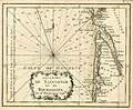 | Details | Bonne, Rigobert | 1778 |
| Antique miniature chart of the Biscayan coast near Bordeaux, France |
|
Bonne, Rigobert |
|
| 1778 |
| LOC:7 |
| $120.00 | Bonne--Rigobert | Antique-miniature-chart-of-the-Biscayan-coast-near-Bordeaux--France | Fine antique French miniature nautical chart of the <b>Bourdelois Coast</b> of France near Bourdeaux, France, Cape Ferret, Blaye and the Gironde River.
<br></br>
From Rigobert Bonne's miniature nautical atlas "Atlas maritime ou Cartes réduites de toutes les Côtes de France avec des cartes particulières des isles voisines les plus considérables, suivies des plans des principales villes maritimes de ce royaume." One of 12 charts published in the Atlas Maritime which are considered to among the very few miniature nautical charts published during the golden age of miniature maps . Published by Lattre from Paris. With the royal privilege. No. 6.
<br></br>
This scarce miniature copper-plate engraving contains much of the same information found on larger charts- rhumb lines; an adjustment for magnetic variation; numerous depth soundings; headlands, capes, navigation hazards and sand banks that are clearly identified.
<br></br>
Rigobert Bonne (1727-1794) was the successor to Jacques Nicolas Bellin as Royal Cartographer to France in the office of the Hydrographer at the Depôt de la Marine. Bonne first came to prominence when he published a number of charts in the Atlas Maritime in 1762. He is better known for later publications, including the Atlas Encyclopedique, which he collaborated on with Nicholas Desmarest, as well as the maps he produced for Raynal's Atlas de Toutes Les Parties Connues du Globe Terrestre, which was published in 1780. |
| 1267 | 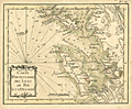 | Details | Bonne, Rigobert | 1778 |
| Isle de Re and Isle d'Oleron, France |
|
Bonne, Rigobert |
|
| 1778 |
| LOC:0 |
| $0.00 | Bonne--Rigobert | Isle-de-Re-and-Isle-d-Oleron--France | SOLD
<br></br>
Antique miniature nautical chart of the Atlantic west coast of France near Rochefort and la Rochelle. Includes the <b>Isle de Re</b> and the <b>Isle d'Oleron</b>. The Pertuis d'Antioche, a strait on the western coast of France lies between the two islands.
<br></br>
From Rigobert Bonne's miniature nautical atlas "Atlas maritime ou Cartes réduites de toutes les Côtes de France avec des cartes particulières des isles voisines les plus considérables, suivies des plans des principales villes maritimes de ce royaume." One of 12 charts published in the Atlas Maritime which are considered to among the very few miniature nautical charts published during the golden age of miniature maps .
<br></br>
Published by Lattre from Paris. With the royal privilege. No. 12.
<br></br>
This scarce miniature copper-plate engraving contains much of the same information found on larger charts- rhumb lines; an adjustment for magnetic variation; numerous depth soundings; headlands, capes, navigation hazards and sand banks that are clearly identified.
<br></br>
Rigobert Bonne (1727-1794) was the successor to Jacques Nicolas Bellin as Royal Cartographer to France in the office of the Hydrographer at the Depôt de la Marine. Bonne first came to prominence when he published a number of charts in the Atlas Maritime in 1762. He is better known for later publications, including the Atlas Encyclopedique, which he collaborated on with Nicholas Desmarest, as well as the maps he produced for Raynal's Atlas de Toutes Les Parties Connues du Globe Terrestre, which was published in 1780. |
| 1253 | 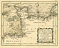 | Details | Bonne, Rigobert | 1778 |
| Antique miniature chart of the coasts of Normandy and Brittany |
|
Bonne, Rigobert |
|
| 1778 |
| LOC:0 |
| $0.00 | Bonne--Rigobert | Antique-miniature-chart-of-the-coasts-of-Normandy-and-Brittany | SOLD
<br></br>
Fine antique miniature nautical chart from 1778 of France's <b>Normandy and Brittany coastline</b> along the English Channel. Coverage at sea includes the Channel Islands of Guernsey, Jersey, and Alderney. Ports and towns shown include St. Malo, Avranche, Cherbourg, Barfleur, Bayeux, Caen, Havre du Grace (La Havre). This scarce chart was published during the golden age for miniature maps and is one of the few miniature charts printed during that period.
<br></br>
From Rigobert Bonne's miniature nautical atlas "Atlas maritime ou Cartes réduites de toutes les Côtes de France avec des cartes particulières des isles voisines les plus considérables, suivies des plans des principales villes maritimes de ce royaume." One of 12 miniature charts published in the Atlas Maritime. Published by Lattre from Paris. With the royal privilege. No. 3.
<br></br>
This scarce miniature copper-plate engraving contains much of the same information found on larger charts- rhumb lines; an adjustment for magnetic variation; numerous depth soundings; headlands, capes, navigation hazards and sand banks that are clearly identified.
<br></br>
Rigobert Bonne (1727-1794) was the successor to Jacques Nicolas Bellin as Royal Cartographer to France in the office of the Hydrographer at the Depôt de la Marine. Bonne first came to prominence when he published a number of charts in the Atlas Maritime in 1762. He is better known for later publications, including the Atlas Encyclopedique, which he collaborated on with Nicholas Desmarest, as well as the maps he produced for Raynal's Atlas de Toutes Les Parties Connues du Globe Terrestre, which was published in 1780. |
| 1236 | 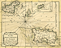 | Details | Bonne, Rigobert | 1778 |
| Antique miniature chart of Channel Islands Jersey Guernsey and Alderney |
|
Bonne, Rigobert |
|
| 1778 |
| LOC:0 |
| $0.00 | Bonne--Rigobert | Antique-miniature-chart-of-Channel-Islands-Jersey-Guernsey-and-Alderney | SOLD<br></br>
Fine antique miniature nautical chart of the <b>Channel Islands</b> (Îles de la Manche) in the English Channel off the French coast of Normandy. Coverage on this attractive miniature sea chart includes the islands of Jersey, Guernsey (Grenesey) , Alderney (Aurigni), Sark (Cers), Herm (Herms), Jethou (Gethou) and Brecqhou.
<br></br>
Despite its small size this scarce copper-plate engraving contains much of what is found on larger charts- anchorages are clearly marked; depth soundings are numerous; hazards and sand banks are clearly identified. In addition Bonne provides a great amount of detail about the interior topography and geography of the Channel Islands.
<br></br>
From Rigobert Bonne's miniature nautical atlas "Atlas maritime ou Cartes réduites de toutes les Côtes de France avec des cartes particulières des isles voisines les plus considérables, suivies des plans des principales villes maritimes de ce royaume." One of 12 charts published in the Atlas Maritime which are considered to among the very few miniature nautical charts published during the golden age of miniature maps . Published by Lattre from Paris. With the royal privilege. No. 10.
<br></br>
Rigobert Bonne (1727-1794) was the successor to Jacques Nicolas Bellin as Royal Cartographer to France in the office of the Hydrographer at the Depôt de la Marine. Bonne first came to prominence when he published a number of charts in the Atlas Maritime in 1762. He is better known for later publications, including the Atlas Encyclopedique, which he collaborated on with Nicholas Desmarest, as well as the maps he produced for Raynal's Atlas de Toutes Les Parties Connues du Globe Terrestre, which was published in 1780. |
| 1241 | 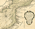 | Details | Bonne, Rigobert | 1778 |
| Miniature antique nautical chart of the Strait of Dover |
|
Bonne, Rigobert |
|
| 1778 |
| LOC:7 |
| $160.00 | Bonne--Rigobert | Miniature-antique-nautical-chart-of-the-Strait-of-Dover | Fine miniature antique nautical chart of the coasts near the <b>Strait of Dover</b> (Pas de Calais), the narrowest part of the English Channel. Coverage on this attractive miniature sea chart includes coastal France and England. Bonne shows a few towns on the English side of the channel including Hastings, Rye, Dover (Douvres) , Romney and Sandwich. On the French and Belgian side of the English channel Bonne locates numerous towns and villages including Ostend, Dunkirk, Calais, Boulogne, Etaples, Montreuil, Abbeville, Dieppe, and Fecamp.
<br></br>
Despite its small size this scarce miniature engraving contains most features found on larger sea charts- numerous headlands are noted; depth soundings are provided; anchorages, hazards and sand banks are clearly identified; and rhumb lines are provided with a 18 3/4 degree compass adjustment for magnetic variation. Unlike several other charts in the series, on this particular miniature chart Bonne provides very little detail about the interior topography of either England or France.
<br></br>
From Rigobert Bonne's miniature nautical atlas "Atlas maritime ou Cartes réduites de toutes les Côtes de France avec des cartes particulières des isles voisines les plus considérables, suivies des plans des principales villes maritimes de ce royaume." One of 12 charts published in the Atlas Maritime which are considered to among the very few miniature nautical charts published during the golden age of miniature maps . Published by Lattre from Paris. With the royal privilege. No. 2.
<br></br>
Rigobert Bonne (1727-1794) was the successor to Jacques Nicolas Bellin as Royal Cartographer to France in the office of the Hydrographer at the Depôt de la Marine. Bonne first came to prominence when he published a number of charts in the Atlas Maritime in 1762. |
| 71 | 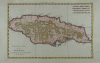 | Details | Bonne, Rigobert | 1780 |
| Carte de l'Isle de la Jamaique |
|
Bonne, Rigobert |
|
| 1780 |
| LOC:5 |
| $150.00 | Bonne--Rigobert | Carte-de-l-Isle-de-la-Jamaique | Attractive hand-colored antique chart by Bonne ca. 1780. Horizontal format of the island of Jamaica showing extensive mountain ranges. Spanish Town, Fort "Ahgusta", and Port Royal Harbor clearly identified. |
| 1270 | 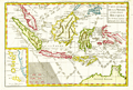 | Details | Bonne, Rigobert | 1780 |
| Attractive antique map of the East Indies and north Australia |
|
Bonne, Rigobert |
|
| 1780 |
| LOC:0 |
| $0.00 | Bonne--Rigobert | Attractive-antique-map-of-the-East-Indies-and-north-Australia | SALE PENDING <br></br>
Attractive antique copperplate-engraved map of the islands of Java, Sumatra, Celebes, Malaca, Borneo, New Guinea (shown only partially due to incomplete exploration in the late 18th century) as well as the tip of Australia's northern coast(s) with each side of the Cape York Peninsula or "Terre du Sud" named: Terre de Diemen (west) and Terre d'Arnheim (east).
<br></br>
Arrow notations depict the directions of the winds during the various months of the year. Includes an inset map of the Moluccan Islands - the Spice Islands.
<br></br>
From "Atlas de toutes les parties connues du Globe Terrestre, dressé pour l’histoire philosophique et politique des établissemens et du commerce des européens dans les deux Indes. "
<br></br>
Rigobert Bonne (1727-1794) was the successor to Jacques Nicolas Bellin as Royal Cartographer to France in the office of the Hydrographer at the Depôt de la Marine. Bonne first came to prominence when he published a number of charts in the Atlas Maritime in 1762. He is better known for later publications, including the Atlas Encyclopedique, which he collaborated on with Nicholas Desmarest, as well as the maps he produced for Raynal's Atlas de Toutes Les Parties Connues du Globe Terrestre, which was published in 1780. |
| 1406 | 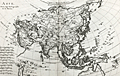 | Details | Bonne, Rigobert | 1780 |
| Nice antique map of Asia with Australia |
|
Bonne, Rigobert |
|
| 1780 |
| LOC:9 |
| $160.00 | Bonne--Rigobert | Nice-antique-map-of-Asia-with-Australia | Antique map of Asia by French hydrographer Rigobert Bonne. Coverage on this copper-plate engraved map includes Saudi Arabia, India, China, New Guinea, northern Australia ("Nouvelle Hollande"), New Zealand., Japan, Korea, and much more. Coverage extends far to the east to include Alaska with the Bering Strait and the Alaska Peninsula. No. 28.
<br></br>
Rigobert Bonne (1727-1794) was the successor to Jacques Nicolas Bellin as Royal Cartographer to France in the office of the Hydrographer at the Depôt de la Marine. Bonne first came to prominence when he published a number of charts in the Atlas Maritime in 1762. He is better known for later publications, including the Atlas Encyclopedique, which he collaborated on with Nicholas Desmarest, as well as the maps he produced for Raynal's Atlas de Toutes Les Parties Connues du Globe Terrestre, which was published in 1780. This map is from Raynal's atlas. |
| 1331 | 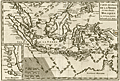 | Details | Bonne, Rigobert | 1780 |
| Fine antique map of the Moluccas and North Australia |
|
Bonne, Rigobert |
|
| 1780 |
| LOC:6 |
| $240.00 | Bonne--Rigobert | Fine-antique-map-of-the-Moluccas-and-North-Australia | Attractive antique uncolored copperplate-engraved map of the islands of Java, Sumatra, Celebes, Malaca, Borneo, New Guinea (shown only partially due to incomplete exploration in the late 18th century) as well as the tip of Australia's northern coast(s) with each side of the Cape York Peninsula or "Terre du Sud" named: Terre de Diemen (west) and Terre d'Arnheim (east).
<br></br>
Arrow notations depict the directions of the winds during the various months of the year. Includes an inset map of the Moluccan Islands - the Spice Islands.
<br></br>
From "Atlas de toutes les parties connues du Globe Terrestre, dressé pour l’histoire philosophique et politique des établissemens et du commerce des européens dans les deux Indes. "
<br></br>
Rigobert Bonne (1727-1794) was the successor to Jacques Nicolas Bellin as Royal Cartographer to France in the office of the Hydrographer at the Depôt de la Marine. Bonne first came to prominence when he published a number of charts in the Atlas Maritime in 1762. He is better known for later publications, including the Atlas Encyclopedique, which he collaborated on with Nicholas Desmarest, as well as the maps he produced for Raynal's Atlas de Toutes Les Parties Connues du Globe Terrestre, which was published in 1780. |
| 1335 | 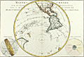 | Details | Bonne, Rigobert | 1787 |
| Western Hemisphere - Antique 45 Degree Southern Oblique Projection |
|
Bonne, Rigobert |
|
| 1787 |
| LOC:0 |
| $0.00 | Bonne--Rigobert | Western-Hemisphere---Antique-45-Degree-Southern-Oblique-Projection | SOLD
<br></br>
Early antique projection covering the Western Hemisphere taken from 45 degrees south latitude. Includes North America, South America, eastern Australia, New Zealand and the South Pacific Islands. The Hawaiian Islands are named the "Iles Sandwich."
<br></br>
An attractive copper-plate engraved map produced by Rigobert Bonne and crisply and finely engraved by Andre to include mountain ranges and numerous place names. Includes two related views on the plate including one colorful view of the "Sphere Oblique."
<br></br>
Rigobert Bonne (1727-1794) was the successor to Jacques Nicolas Bellin as Royal Cartographer to France in the office of the Hydrographer at the Depôt de la Marine. Bonne first came to prominence when he published a number of charts in the Atlas Maritime in 1762, but Bonne is better known for later publications, including the Atlas Encyclopedique, which he collaborated on with Nicholas Desmarest, as well as the maps he produced for Raynal's Atlas de Toutes Les Parties Connues du Globe Terrestre. Published in Paris in 1787. Plate 25. |
| 1336 | 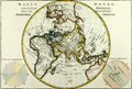 | Details | Bonne, Rigobert | 1787 |
| Eastern Hemisphere - Antique 45 Degree Northern Oblique Projection |
|
Bonne, Rigobert |
|
| 1787 |
| LOC:9 |
| $245.00 | Bonne--Rigobert | Eastern-Hemisphere---Antique-45-Degree-Northern-Oblique-Projection | Early antique projection covering the Eastern Hemisphere taken from 45 degrees north latitude. Includes the North Pole, northern North America with Alaska; Africa, Madagascar, Europe, Japan, western Australia (Nouvelle Hollande"), and New Zealand. A very fine copper-plate engraved map produced by Rigobert Bonne and crisply and finely engraved by Andre to include mountain ranges and numerous place names. Includes two related views on the plate including one colorful view of the "Sphere Oblique" and another obtuse drawing labeled "Effet de Pesanteur".
<br></br>
Rigobert Bonne (1727-1794) was the successor to Jacques Nicolas Bellin as Royal Cartographer to France in the office of the Hydrographer at the Depôt de la Marine. Bonne first came to prominence when he published a number of charts in the Atlas Maritime in 1762, but Bonne is better known for later publications, including the Atlas Encyclopedique, which he collaborated on with Nicholas Desmarest, as well as the maps he produced for Raynal's Atlas de Toutes Les Parties Connues du Globe Terrestre. Published in Paris in 1787. Plate 24. |
| 1306 | 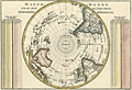 | Details | Bonne, Rigobert | 1787 |
| Antique Pre-Antarctica Southern Polar Projection |
|
Bonne, Rigobert |
|
| 1787 |
| LOC:9 |
| $325.00 | Bonne--Rigobert | Antique-Pre-Antarctica-Southern-Polar-Projection | Early antique South polar projection covering from the South Pole to the Equator. Produced by Bonne before the dimensions of continental Antarctica were known. This colorful antique map includes Australia (Nouvelle Hollande) and New Guinea.
<br></br>
Crisply and finely engraved to include mountain ranges and numerous place names with islands given extra coverage. Surrounded by two tables showing the distance corresponding to one degree at different latitudes. Published in Paris in 1787. Plate 23. |
| 1308 | 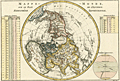 | Details | Bonne, Rigobert | 1787 |
| Antique Northern Polar Projection |
|
Bonne, Rigobert |
|
| 1787 |
| LOC:0 |
| $0.00 | Bonne--Rigobert | Antique-Northern-Polar-Projection | SOLD
<br><br/>
Early antique North polar projection covering the Northern Hemisphere from the North Pole to the Equator. |
| 1413 | 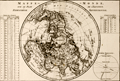 | Details | Bonne, Rigobert | 1787 |
| Antique Northern Polar Projection or Hemisphere Septentrional |
|
Bonne, Rigobert |
|
| 1787 |
| LOC:9 |
| $180.00 | Bonne--Rigobert | Antique-Northern-Polar-Projection-or-Hemisphere-Septentrional | Attractive North polar projection covering the Northern Hemisphere or "Hemisphere Septentrional" from the North Pole to the Equator. Early French copper-plate engraved map produced by Rigobert Bonne and crisply and finely engraved by Andre' to include mountain ranges and numerous place names. Surrounded by two tables of climatological data and a view of the "Sphere Parallele." Published in Paris in 1787. Plate 22.
<br></br>
Rigobert Bonne (1727-1794) was the successor to Jacques Nicolas Bellin as Royal Cartographer to France in the office of the Hydrographer at the Depôt de la Marine. Bonne first came to prominence when he published a number of charts in the Atlas Maritime in 1762, but Bonne is better known for later publications, including the Atlas Encyclopedique, which he collaborated on with Nicholas Desmarest, as well as the maps he produced for Raynal's Atlas de Toutes Les Parties Connues du Globe Terrestre. |
| 1414 | 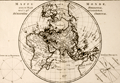 | Details | Bonne, Rigobert | 1787 |
| Northern Oblique Projection of eastern Hemisphere or Hemisphere Oriental. |
|
Bonne, Rigobert |
|
| 1787 |
| LOC:0 |
| $0.00 | Bonne--Rigobert | Northern-Oblique-Projection-of-eastern-Hemisphere-or-Hemisphere-Oriental- | SOLD<br></br>
Early antique projection covering the Eastern Hemisphere or "Hemisphere Oriental" taken from 45 degrees north latitude. Includes the North Pole, northern North America with Alaska; Africa, Madagascar, Europe, Japan, western Australia (Nouvelle Hollande"), and New Zealand. A very fine copper-plate engraved map produced by Rigobert Bonne and crisply and finely engraved by Andre to include mountain ranges and numerous place names. Includes two related views on the plate including one colorful view of the "Sphere Oblique" and another obtuse drawing labeled "Effet de Pesanteur".
<br></br>
Rigobert Bonne (1727-1794) was the successor to Jacques Nicolas Bellin as Royal Cartographer to France in the office of the Hydrographer at the Depôt de la Marine. Bonne first came to prominence when he published a number of charts in the Atlas Maritime in 1762, but Bonne is better known for later publications, including the Atlas Encyclopedique, which he collaborated on with Nicholas Desmarest, as well as the maps he produced for Raynal's Atlas de Toutes Les Parties Connues du Globe Terrestre. Published in Paris in 1787. Plate 24. |
| 3632 | 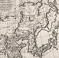 | Details | Bonne, Rigobert | 1787 |
| Fine antique map of China, Korea and Japan |
|
Bonne, Rigobert |
|
| 1787 |
| LOC:9 |
| $265.00 | Bonne--Rigobert | Fine-antique-map-of-China--Korea-and-Japan | Map of China, Korea and Japan includes only northern China, extending south as far as Nanjing. Numerous cities are shown spread throughout China, however fewer are shown in Korea and Japan reflecting the lack of knowledge of these regions in the late 18th century. The Great Wall of China is also depicted.
<br></br>
Rigobert Bonne (1727-1794) was the successor to Jacques Nicolas Bellin as Royal Cartographer to France in the office of the Hydrographer at the Depôt de la Marine. Bonne first came to prominence when he published a number of charts in the Atlas Maritime in 1762. He is better known for later publications, including the Atlas Encyclopedique, which he collaborated on with Nicholas Desmarest, as well as the maps he produced for Raynal's Atlas de Toutes Les Parties Connues du Globe Terrestre, which was published in 1780. |
| 1428 | 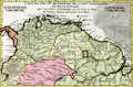 | Details | Bonne, Rigobert | 1787 |
| Antique map of northern South America |
|
Bonne, Rigobert |
|
| 1787 |
| LOC:50 |
| $99.00 | Bonne--Rigobert | Antique-map-of-northern-South-America | Fine hand-colored antique map of northern South America with portions of Colombia, Venezuela, Brazil and Chile and neighboring countries to the south. Includes the Amazon River basin. By R. Bonne a cartographer and hydrographer who produced maps of both land and sea, although his work leaned more toward the sea for reasons expressed below. Number 31.
<br></br>
Rigobert Bonne (1727-1794) was the successor to Jacques Nicolas Bellin as Royal Cartographer to France in the office of the Hydrographer at the Depôt de la Marine. Bonne first came to prominence when he published a number of charts in the Atlas Maritime in 1762, but Bonne is better known for later publications, including the Atlas Encyclopedique, which he collaborated on with Nicholas Desmarest, as well as the maps he produced for Raynal's Atlas de Toutes Les Parties Connues du Globe Terrestre. Published in Paris in 1787.
<br></br>
This site offers several charts from Bonne's miniature nautical atlas "Atlas maritime ou Cartes réduites de toutes les Côtes de France ..." The 12 small charts of coastal France in the Atlas Maritime are considered to be among the very few miniature nautical charts published during the golden age of miniature maps. |
| 737 | 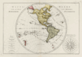 | Details | Bonne, Rigobert | 1787 |
| 18th Century Antique World Map of the Western Hemisphere |
|
Bonne, Rigobert |
|
| 1787 |
| LOC:0 |
| $0.00 | Bonne--Rigobert | 18th-Century-Antique-World-Map-of-the-Western-Hemisphere | SOLD <br></br>
Antique French map of the Western Hemisphere by cartographer Rigobert Bonne from Paris. The copper-plate engraving includes a very decorative compass rose, "Rose de Boussole", at right with all 32 compass points attributed to their named winds in the Mediterranean Sea (e.g., Levante, Syroco, Greco, Ostro, Ponente, Tramontana, etc.) At left is a representation of the globe divided into imaginary climatic zones by the Equator, Tropic of Cancer, Tropic of Capricorn and the Arctic and Antarctic polar circles. Key features include New Zealand, North America, Bering Strait, South America, the Sandwich Islands (Hawaii), numerous islands in the Pacific Ocean, and the Azores Islands. The southernmost point depicted consists of the South Sandwich island group including South Georgia Island.
<br></br>
Rigobert Bonne was the successor to Jacques Nicolas Bellin as Royal Cartographer to France in the office of the Hydrographer at the Depôt de la Marine. This engraved 18th-century plate was published in 1787 in Bonne's ATLAS ENCYCLOPEDIQUE CONTENANT LA GEOGRAPHIA ANCIENNE, ET QUELQUES CARTES SUR LA GEOGRAPHIE DU MOYEN AGE, LA GEOGRAPHIE MODERNE, ET LES CARTES RELATIVES A LA GEOGRAPHIE PHISIQUE…. . Plate 21. |
| 738 | 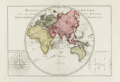 | Details | Bonne, Rigobert | 1787 |
| Antique World Map of the Eastern Hemisphere including Australia |
|
Bonne, Rigobert |
|
| 1787 |
| LOC:0 |
| $0.00 | Bonne--Rigobert | Antique-World-Map-of-the-Eastern-Hemisphere-including-Australia | SOLD<br></br>
Antique French map of the Eastern Hemisphere by cartographer Rigobert Bonne from Paris. Key features include a misshapen, elongated Australian continent, and Africa, China, and Europe. Significantly, no land mass is shown south of the Antarctic circle as the first sighting of land below 60 degrees south latitude did not occur until 1820.
<br></br>
The copper-plate engraving includes a very decorative compass rose: "Rose de Boussole avec les noms des Vents en usage sur le Ocean.", at left with all 32 compass points attributed to their named winds in the Ocean Sea (e.g., Nord, Sud, Est, Ouest, etc.)
<br></br>
Rigobert Bonne was the successor to Jacques Nicolas Bellin as Royal Cartographer to France in the office of the Hydrographer at the Depôt de la Marine. This engraved 18th-century plate was published in 1787 in Bonne's ATLAS ENCYCLOPEDIQUE CONTENANT LA GEOGRAPHIA ANCIENNE, ET QUELQUES CARTES SUR LA GEOGRAPHIE DU MOYEN AGE, LA GEOGRAPHIE MODERNE, ET LES CARTES RELATIVES A LA GEOGRAPHIE PHISIQUE…. . Plate 20. |