| | Thumbnail | | Creator | Date | Title / Author / Date / Location | Price | | | Description |
| 5279 | 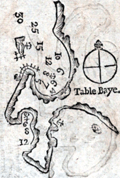 | Details | Bougard, Rene | 1785 |
| Rare woodcut chart Table Bay Saldanha Bay South Africa |
|
Bougard, Rene |
|
| 1785 |
| LOC: |
| $350.00 | Bougard--Rene | Rare-woodcut-chart-Table-Bay-Saldanha-Bay-South-Africa | Two scarce 18th-century woodcut harbor charts for South Africa on a single sheet. This fine antique harbor chart covers Table Bay, near Cape Town, South Africa and the Cape of Good Hope (Cap de Bonne Esperance). Verso contains another woodcut harbor chart of the Bay of Saldanha, on Africa's west coast about 70 statute miles northwest of Cape Town.
<br><br/>
From the atlas "Petit Flambeau de la Mer", published in more than 12 editions beginning in 1683 [1785] from le Havre, France by Rene Bougard. Printed area measures 4" x 6" on a larger sheet of laid paper. On the title page Bougard is listed as a Lieutenant of France's Vaisseau du Roi or the French sailing navy. The French navy was headquartered in Toulon while the French galley corps was at that time considered a separate entity and was based mainly at Marseille, France. French text.
<br><br/>
Copies of Bougard's harbor charts are rare and seldom found available for sale.
<br><br/>
Full title of Bougard's atlas is: "Le Petit Flambeau de la mer ou le veritable guide des pilotes cotiers ; Où il est clairement enseigné la maniere de naviguer le long de toutes les Cotes de France, d’Angleterre, d’Irlande, d’Espagne, de Portugal, d’Italie, de Sicile, de Malte, de Corse & de Sardaigne, & autres isles du Detroit; & des Cotes de Barbarie . . . " |