| | Thumbnail | | Creator | Date | Title / Author / Date / Location | Price | | | Description |
| 1309 | 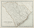 | Details | Bradford, Thomas G. | 1838 |
| 1838 Map of South Carolina by Thomas Bradford |
|
Bradford, Thomas G. |
|
| 1838 |
| LOC:10 |
| | Bradford--Thomas-G- | 1838-Map-of-South-Carolina-by-Thomas-Bradford | SOLD
<br></br>
A fine ante-bellum engraved map of the state of South Carolina with 32 districts ( counties ). Includes hundreds of named geographic features like Kiawah Island, Hilton Head, Folly Island, Charleston, Waccamaw River, Edisto River, Port Beaufort, and more.
<br></br>
A very early map of South Carolina with only one interior railway line, from Charleston to Columbia and Augusta. Displays rivers, Post Offices (e.g. Harley's P.O.; Fulton's P.O.; Beckhamville P.O.) , and numerous swamps (e.g. Hell Hole Swamp; Buck Swamp; Cedar Swamp ... ). Clearly shows the now flooded Santee Canal, opened in 1800, an inland canal linking the Cooper River near Charleston with the Santee River.
<br></br>
Attribution at bottom left reads: "Entered according to Act of Congress in the year 1838 by T.G. Bradford, in the Clerk's office of the District Court of Massachusetts. inland canal linking the Cooper River near Charleston, with the Santee River. Engraved by G.W. Boynton |