| | Thumbnail | | Creator | Date | Title / Author / Date / Location | Price | | | Description |
| 1427 | 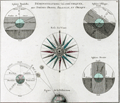 | Details | Brion, Louis, de la Tour | 1766 |
| 18th-century astronomical engraving of spherical orientations |
|
Brion, Louis, de la Tour |
|
| 1766 |
| LOC:9 |
| $250.00 | Brion--Louis--de-la-Tour | 18th-century-astronomical-engraving--of-spherical-orientations | Attractive antique engraving ca. 1766 related to astronomy and in particular to the viewer's perception of various two-dimensional orientations of the earth including the oblique and parallel projections.
<br></br>
Brion's diagrams are organized around a large, attractive, and very decorative compass rose. Additionally, a large and decorative border surrounds the entire print. Two plates were used in the production of this print, one plate for the border, evidenced by the nesting platemarks plainly visible to the viewer. Number 4.
<br></br>
From the "Atlas général civil et ecclésiastique" by Louis Brion de la Tour, Ingénieur-géographe du Roi. |
| 1471 | 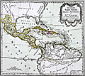 | Details | Brion, Louis, de la Tour | 1790 |
| Guyane, Terre Ferme. Isles Antilles et Nouvelle Espagne |
|
Brion, Louis, de la Tour |
|
| 1790 |
| LOC:10 |
| $130.00 | Brion--Louis--de-la-Tour | Guyane--Terre-Ferme--Isles-Antilles-et-Nouvelle-Espagne | Antique map of the Caribbean Archipelago, Mexico, and the southeast United States. Map is set within a page of French text related to the map. |