| | Thumbnail | | Creator | Date | Title / Author / Date / Location | Price | | | Description |
| 4994 | 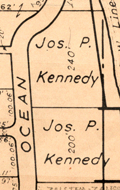 | Details | Brockway, George S. | 1936 |
| Lot of 3 maps Palm Beach Atlas Florida MS notes |
|
Brockway, George S. |
|
| 1936 |
| LOC:11 |
| $525.00 | Brockway--George-S- | Lot-of-3-maps-Palm-Beach-Atlas-Florida-MS-notes | Lot of three (3) scarce cadastral maps from the Palm Beach, Florida Atlas ca. 1936 by Civil Engineer George S. Brockway. Data printed on each sheet include tract/development name, deed reference location, lot dimensions, street names and lot number.
<br></br>
Sheets may contain manuscript pencil notations (ca. 1947 / 1948) with additional property owner names, property prices and indications of whether there was a structure on the property. Verso of each sheet contains Brockway's ink-stamped disclaimer of legal responsibility.<br></br>
<b>Details for the three atlas plates include</b>
<div class="indenttextblocksingle">
<ul style="list-style-type: circle;">
<li>Sheet 5: Covers an area bounded by Merrain Road (N), La Puerta Way (S), Lake Worth (W), Atlantic Ocean (E). Developments include the Bello Lido, Alto Lido and Mockingbird Trail tracts. </li>
<li>Sheet 6: Covers and area bounded by La Puerta Way (N), Orange Grove Road (S) - Lake Worth (W) Atlantic Ocean (E). Includes developments of Palm Beach Shores, Gregory Addition and the New Siears tracts. Shows the former <b>Kennedy Estate with two lots owned by Joseph P. Kennedy</b> totaling 440 feet of ocean frontage.</li>
<li>Sheet 15-A: Bounded by Seminole Ave (N), Royal Poinciana Way (S), Lake Worth (W), North County Road (E) Includes the Flagler Memorial Bridge, old <b>Biltmore Hotel and the Beach Club</b>. Developments include Ocean Park, Floral Park, and Bungalow Park.</li>
</ul>
</div> |
| 5293 | 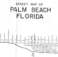 | Details | Brockway, George S. | 1940 |
| Promotional street map of Palm Beach Florida |
|
Brockway, George S. |
|
| 1940 |
| LOC:87 |
| $325.00 | Brockway--George-S- | Promotional-street-map-of-Palm-Beach-Florida | Promotional street map of Palm Beach, Florida from the Chamber of Commerce ca. 1940. A simplified map for visitors; limited in scope, this edition lacks detailed coverage of West Palm Beach and does not include either a key to street names or names of the inhabitants found in other similar maps by Brockway. Dated with reference to "Island no. 17" which is labeled "Pinner's Island" in Brockway's 1942 edition.
<br></br>
Verso is blank but with a blue ink stamp: "Courtesy of the Palm Beach Chamber of Commerce."
<br></br>
The map spans an area of southern Palm Beach from the Southern Boulevard Bridge (now Bingham Island Bridge) at north, past the Lake Worth Bridge, and terminating past the Lantana Bridge near the north corporate limits of Manalapan. By George S. Brockway, Engineer.
<br></br>
Features on the map include:
<div class="indenttextblocksingle">
<ul style="list-style-type: circle;">
<li>Lake Worth Municipal Golf Course</li>
<li>Phipps Ocean Park</li>
<li>Ibis Isle</br>
<li>Lake Worth Municipal Casino and Pool</li>
<li>South Ocean Club</li>
<li>WWPG radio broadcasting station</li>
<li>Island 17 and Island 18</li>
<li>Ambassador Hotel Villas</li>
<li>Hypoluxo Island</br>
</ul>
</div>
<br>
Two manuscript notations in pencil apparently for additions of Clifton and Corley Streets.
<br></br>
North oriented to right. Scale 1 inch = 1 mile. |