| | Thumbnail | | Creator | Date | Title / Author / Date / Location | Price | | | Description |
| 3634 | 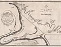 | Details | Buache, Philippe | 1753 |
| Antique maps of the Seine River |
|
Buache, Philippe |
|
| 1753 |
| LOC:77 |
| $325.00 | Buache--Philippe | Antique-maps-of-the-Seine-River | Two informative mid eighteenth-century maps of the Seine River on one sheet. The smaller-scale main map covers the Seine's course from Paris, past numerous tributaries, past Pistres (modern Pîtres), to Pont de l'Arche. The bridge at Pont de l'Arche was erected in the 9th century by Charles the Bald who believed that a fortified bridge in that location would prevent Viking longships from sailing upriver.
<br></br>
A larger inset map at larger scale shows the river flowing from Pistres, with a "Palais Royal" to Rouen with greater detail given to the topography and to depictions of the many islands inhabiting the river. Of particular interest is L'île aux Boeufs (then Isle de Oissel).
<br></br>
Verso is blank. From Memoire de l'Academy Vol 20. Page 109. By Philippe Buache, Member of the Academy of Sciences and "Premier Geographe du Roi".<br> |